NEW ADVANCED HURRICANE MODEL AIDS NOAA FORECASTERS
"June 27, 2007 NOAA’s National Centers for Environmental Prediction and its National Hurricane Center forecasters will now use the Hurricane Weather and Research Forecast Model to predict the track and strength of storms this hurricane season."
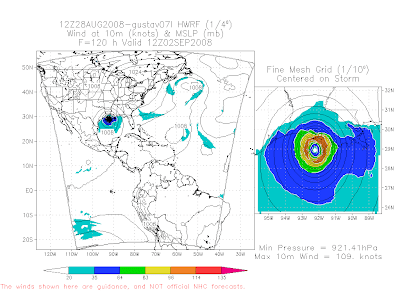
Note the HWRF is projecting a strong Cat 3 with maximum sustained winds of 125 miles per hour making landfall in the marshes of the Central Louisiana Coast.
---


2 comments:
Mike...
Be sure to check out Brian Peter's post on the 33/40 blog on what the European model is spitting out. Almost unthinkable, likely won't happen...but not entirely impossible either especially in 2008.
- J.P.
Thanks James. I was busy with the boys last night but I saw that very ealy this morning.
Post a Comment