Thursday, January 31, 2008

Storm Alert 2008

Tonight the boys and I are attending ABC 33/40's Storm Alert 2008 in Oak Grove, Alabama. Oak Grove is in western Jefferson County and was the site of an F5 tornado on April 8, 1998 which killed 32 people in Jefferson County, AL. The twister traveled east-northeast impacting Oak Grove, Concord, Pleasant Grove, Edgewater, McDonald's Chapel, and Pratt City. F5 damage was in the Concord, McDonalds Chapel, and Edgewater areas. I recently posted a seven minute video on YouTube of the damage I captured on video one month after the tornado. That was a very sad day in Alabama history. The Birmingham NWS and James Spann did an excellent job that day and probably saved numerous lives.

I will post more on this later...


Wednesday, January 30, 2008

Sunsets from one end of Alabama to another...

These are sunset pictures captured by the ABC 33/40 Skycams this evening at 5:05.


Gadsden, Alabama


Mount Cheaha, Alabama


Demopolis, Alabama


Selma, Alabama


Gulf Shores, AL

Last night's winds

At least two injuries were reported from last night's non-thunderstorm wind event in North Alabama

Last night's storms were not severe. However, as expected we had some very nice rainfall totals and lots of non-thunderstorm high winds. Rainfall at my location totaled .86". Between 8:40 and 8:55 p.m., a few hours after the storms rolled through, very high winds blew across my location in North Alabama.

The winds gusted between 40 and 60 miles per hour in most areas. The highest wind gust I could find was atop the Daniel Building in downtown Birmingham where the ABC 33/40 Skycam recorded a 65 mph gust. Based on the elevation of that anemometer, I have no doubt that was an accurate reading. Power was knocked out in many areas and many trees were blown down across the state. No trees were down in my community to my knowledge but the Culman County EMA did report trees down in parts of the county. My power flickered several times but never was out. My good friend Mike Heflin who lives in the Wren community, just south of Moulton in Lawrence County said his power went out several times, the longest being 10 minutes. He said some trees were down in his community but fortunately for him his fence was unaffected and his cattle did not escape.

Meteorologist Wes Wyatt of WVUA in Tuscaloosa said, "
Last night turned out to be quite busy for us due to numerous reports of wind related damage across our area. More interestingly, this was non-thunderstorm related wind damage as gusts between 40-50 mph accompanied a strong cold front. There were power outages and downed tress all over the area."

The Huntsville NWS reported numerous non-thunderstorm wind damage reports. They reported trees down in the following locations (and other areas not listed here):

Lauderdale County: Florence, Cloverdale, Underwood, Petersville, Rogersville, Zip City, and Waterloo

Colbert County: Cherokee, Muscle Shoals, Tuscumbia

Franklin County: Red Bay, Phil Campbell, Russelville

Lawrence: Courtland, Hatton, Town Creek, Moulton

Limestone: Capshaw, Mooresville, Coxey

Madison: Harvest, Madison, Huntsville, Madison, Meridianville, Moore's Mill

Morgan: Decatur, Trinity

Cullman: Bremen, Dodge City, Cullman, Battleground

---

Some reported wind gusts from the NWS Huntsville include:

Muscle Shoals Airport (Colbert) 55 mph
Harvest (Madison) 54 mph
Decatur (Morgan) 53 mph
Huntsville Airport (Madison) 52 mph
Albertville Airport (Marshall) 52 mph
Madison County 911 Office 51 mph
UAH (Alabama Huntsville) 51 mph
Courtland Airport (Lawrence) 50 mph

---

Dangerously Windy Cold Air by Tim Coleman - Research meteorologist Tim Coleman explains the reasons behind this wind event.

Fast Incoming Reports - J.B. Elliott give a 10 p.m. update of reports from this event.

Wind Damage Jefferson County - James Spann posts some photos of wind damage

Damage from last night - more viewer photos posted by ABC 33/40 Chief Meteorologist James Spann

---

Thousands of Alabama Power Customers without Electricity
Posted by Birmingham News staff January 30, 2008 9:14 AM

"Alabama Power Co. crews are working across the state this morning to restore lines that were blown down in high winds from a cold front that moved across the area Tuesday night. More than 53,000 Alabama Power customers were without service shortly before midnight, but that number was down to under 20,000 by 9 a.m. today, said spokeswoman Carrie Kurlander. Kurlander said the outages included a peak of about 27,000 in the Birmingham area and 21,000 in the Tuscaloosa area. She said less than 8,000 remain without power in the Birmingham area. The National Weather Service reports a peak wind gust of 55 mph at the Birmingham International Airport about 9:27 Tuesday night. Crews will be working through the day to restore service, and Kurlander said all customers shoudl have power by this evening."

Tuesday, January 29, 2008

Strong storm rolled through...


A strong band of storms blew through here between 5:50-5:55. We experienced very heavy rain and estimated winds of 40-45 miles per hour. Nothing severe but some much needed rain, indeed. Rain is still falling at 6:34 and the total is now .74".

Strong storms approaching...


As of 5 p.m. I have received .38" of much needed rain here in Vinemont. The strongest storm in the region is still to my west. As I have felt all along, I do not believe that we will see any true severe weather from this. Earlier a severe thunderstorm warning was issued for Lamar County in West alabama but no damage reports have been received.

Moderate risk to our northwest


PUBLIC SEVERE WEATHER OUTLOOK NWS STORM PREDICTION CENTER NORMAN OK 1041 AM CST TUE JAN 29 2008

...SEVERE THUNDERSTORMS EXPECTED OVER PARTS OF THE LOWER OH AND MISSISSIPPI VALLEYS THIS AFTERNOON AND TONIGHT...

THE NWS STORM PREDICTION CENTER IN NORMAN OK IS FORECASTING THE DEVELOPMENT OF WIDESPREAD DAMAGING WINDS OVER PARTS OF THE LOWER OH AND MISSISSIPPI VALLEYS THIS AFTERNOON AND TONIGHT.

SURROUNDING THE MODERATE RISK AREA...THERE IS A SLIGHT RISK OF SEVERE THUNDERSTORMS FROM NORTHERN LOUISIANA AND MISSISSIPPI NORTHEASTWARD TO THE UPPER OHIO VALLEY.

AN INTENSE UPPER LEVEL STORM SYSTEM IS MOVING EASTWARD FROM KANSAS AND OKLAHOMA TOWARD THE MISSISSIPPI AND OHIO VALLEY REGION. A STRENGTHENING SURFACE LOW PRESSURE AREA WILL MOVE NORTHEASTWARD FROM ILLINOIS TO MICHIGAN IN ADVANCE OF THE UPPER LEVEL SYSTEM...AND AN INTENSE COLD FRONT WILL SWEEP ACROSS THE MISSISSIPPI AND OHIO VALLEYS TO THE SOUTH OF THE LOW PRESSURE AREA.
LOW-LEVEL MOISTURE IS SPREADING NORTHEASTWARD FROM TEXAS AND LOUISIANA TO ARKANSAS AND MISSOURI AS OF LATE MORNING...AND WILL CONTINUE NORTHEASTWARD TO THE LOWER OHIO VALLEY BY LATE AFTERNOON IN ADVANCE OF THE COLD FRONT. INSTABILITY IN ADVANCE OF THE FRONT WILL BE RELATIVELY WEAK COMPARED TO MANY SPRING STORM SYSTEMS...BUT IT WILL BE SUFFICIENT FOR SEVERE STORMS IN A BAND ALONG THE COLD FRONT.

VERY STRONG WINDS IN THE LOWER ATMOSPHERE AND STORM MOTIONS EXCEEDING 50 MPH THIS AFTERNOON SUGGEST THAT WIDESPREAD DAMAGING WINDS WILL BE POSSIBLE ACROSS THE MODERATE RISK AREA THIS AFTERNOON INTO THIS EVENING. EVEN THOUGH INSTABILITY WILL BECOME QUITE WEAK BY EARLY TONIGHT...THE THREAT FOR AT LEAST ISOLATED DAMAGING WINDS MAY PERSIST WELL INTO THE OVERNIGHT HOURS ALONG THE INTENSE COLD FRONT.

Storms today

There is a very good chance that North Alabama will receive some much needed rain today. Also in the mix is the possibility of a few strong thunderstorms. The Storm Prediction Center has placed a good portion of the area under a slight risk area for today.

I think the main threat will be strong straight line winds today. Instability is very limited with this storm system. This morning temperatures are in the low 50’s under overcast skies. I will be surprised if we have enough warm air advection to supply the needed moisture for a classic severe weather outbreak. Having said that, I would not be surprised if we are placed under a tornado watch this afternoon for the possibility of a few isolated small tornadoes.

The most impressive thing about this storm system is the wind fields. As I write, mid-level clouds are rapidly streaming from south to north ahead of this system. We have been placed under a high wind advisory. Today will be windy all day but the highest winds might exceed 50 miles per hour as the main line of storms passes through this afternoon and evening.

I will update later if necessary.

Sunday, January 27, 2008

Upcoming this week...

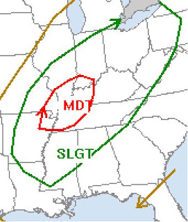
GFS model places a storm midnight Thursday night-Friday morning to our northwest...

On Tuesday we may have strong storms and over one-half inch of rainfall. Severe weather does not seem likely. Later in the week a stronger trough, possibly negatively tilted, will approach Alabama along with deep moisture and a strong jet stream. If all of these factors phase up, we may be in for a round of severe weather Friday.

---

Excerpt from Huntsville AFD this morning...

AS MENTIONED IN PREVIOUS DISCUSSIONS...DEEPENING UPR TROUGH DIGGING
FROM THE PACIFIC NORTHWEST TO THE FOUR CORNERS...WILL SWING ACROSS
THE SOUTHERN PLAINS BY THU AFTN. THE 00Z/27 GFS IS NOT AS AMPLIFIED
AS IT WAS 24 HOURS AGO BUT THE 00Z ECMWF CONTINUES TO SHOW A NEARLY
CLOSED UPR LOW COMING OUT OF THE RED RIVER VALLEY LATE THU. IN
EITHER CASE...A SFC WAVE COMING UP FROM THE GULF IS EXPECTED TO
INTENSIFY AHEAD OF THE UPR LOW AND TRACK NORTHEAST FROM THE LWR MS
VLY TO THE OHIO VALLEY THURSDAY NIGHT INTO FRIDAY. AS THIS OCCURS...
THE THREAT OF WIDESPREAD SHOWERS AND THUNDERSTORMS WILL DEVELOP
ACROSS THE TENNESSEE VALLEY. AT THIS TIME...ITS STILL TOO EARLY TO
DETERMINE THE POTENTIAL STRENGTH OF THIS SYSTEM...BUT MUCH OF THE
AREA REMAINS IN AN ELEVATED RISK OF SEVERE WEATHER FOR THURSDAY
NIGHT AND FRIDAY. IT SHOULD BE NOTED THAT THE POTENTIAL INTENSITY
AND TRACK OF THIS STORM SYSTEM FAVORS SEVERE /POSSIBLE TORNADIC/
WEATHER ACROSS THE TENNESSEE VALLEY.

Friday, January 25, 2008

6:35 update


32.4....just received a call ... sleet and freezing rain on AL HWY 157 near Cullman regional medical Center

a little sleet here in Vinemont currently

Weather update 6 p.m.


The temperature here in Vinemont at 6:00 p.m. is 32.0. Precipitation is approaching according to radar. Some of that precip is probably not reaching the ground.

On a personal note, I have been extremely sick over the past 28 hours. I do feel slightly better as I write. As I feel able I will be posting more on this winter weather situation.

From the NWS Huntsville...


236 PM CST FRI JAN 25 2008

...WINTER WEATHER ADVISORY IN EFFECT FROM 9 PM THIS EVENING TO
8 AM CST SATURDAY...

THE NATIONAL WEATHER SERVICE IN HUNTSVILLE HAS ISSUED A WINTER
WEATHER ADVISORY...WHICH IS IN EFFECT FROM 9 PM THIS EVENING TO
8 AM CST SATURDAY.

PRECIPITATION IN THE FORM OF SLEET AND SNOW IS EXPECTED TO BEGIN
TO ACCUMULATE AROUND 9 PM ACROSS NORTHEAST ALABAMA AND SOUTHERN
MIDDLE TENNESSEE. ACCUMULATIONS WILL BE GREATEST SOUTH OF THE
TENNESSEE RIVER...MAINLY IN CULLMAN...MARSHALL AND SOUTHERN DEKALB
COUNTIES WHERE 1 TO 2 INCHES ARE EXPECTED. FURTHER NORTH...TRACE
TO LESS THAN AN INCH OF ACCUMULATION IS ANTICIPATED. HOWEVER...DUE
TO THE TEMPERATURE REMAINING AROUND FREEZING...ANY ACCUMULATION
WILL REMAIN ON THE GROUND THROUGHOUT THE NIGHT.

AFTER THE SNOW AND SLEET ENDS BY 3 OR 4 AM...A PERIOD OF FREEZING DRIZZLE
WILL LEAVE A LIGHT GLAZE OF ICE...ESPECIALLY AT ELEVATIONS ABOVE
1000 FEET. ALL PRECIPITATION WILL THEN END BY AROUND 8 AM TOMORROW
MORNING...FOLLOWED BY TEMPERATURES RISING ABOVE FREEZING.

A WINTER WEATHER ADVISORY MEANS THAT PERIODS OF SNOW...SLEET...OR
FREEZING RAIN WILL CAUSE TRAVEL DIFFICULTIES. BE PREPARED FOR
SLIPPERY ROADS AND LIMITED VISIBILITIES...AND USE CAUTION WHILE
DRIVING.
---

A WINTRY MIX OF PRECIPITATION IS ANTICIPATED TONIGHT. SNOW AND SLEET WILL ARRIVE EARLY THIS EVENING IN NORTHWEST ALABAMA…SPREADING EAST OF THE INTERSTATE 65 CORRIDOR BETWEEN 9 PM AND MIDNIGHT. ACCUMULATION OF SNOW AND SLEET…ON THE ORDER OF ONE HALF TO ONE INCH IS ANTICIPATED SOUTH OF THE TENNESSEE RIVER…ESPECIALLY ACROSS FRANKLIN…LAWRENCE…AND CULLMAN COUNTIES. ISOLATED SPOTS COULD SEE MORE SNOWFALL THAN SLEET…INCREASING TOTALS TO AS HIGH AS 2 TO 3 INCHES. FURTHER NORTH…A HALF INCH OR LESS OF ACCUMULATION OF SLEET AND SNOW IS EXPECTED. AFTER THE SLEET AND SNOW MIXTURE EXITS LATE TONIGHT…A PERIOD OF FREEZING DRIZZLE IS POSSIBLE…PRODUCING A LIGHT COATING OF ICE.

Thursday, January 24, 2008

1/10/08 Tornadoes in Alabama

Birmingham NWS links to storm surveys:

Windham Springs Tornado (EF3), Tuscaloosa County

Lamar County Tornado (EF3)

Gordo Tornado (EF1), Pickens/Tuscaloosa County

Pickensville Tornado (EF0), Pickens County

Dixon Mills Tornado (EF0), Marengo County

1/10/08 Tornadoes in Mississippi


2:16 pm velocity image from the Columbus, MS Nexrad as an EF3 tornado was in Caledonia, MS

Jackson, MS NWS links to tornado surveys in Mississippi:
Holmes and Attala Counties Tornado EF3
Atalla and Choctaw Counties Tornado EF3
Lowndes County Tornado EF3
Other Notable Tornadoes/Damage Across Central Mississippi

1/16/08 North and Central, AL Wintry Precipitation


Wintry Precipitation January 16, 2008 from the NWS Birmingham. (I must say that I had every bit of 1 1/2 inches of snow in North Cullman County (where the map shows "1/2" at the top). I measured anywhere from 1 1/4" to 1 3/4".

Here is a list of snowfall reports from the NWS Huntsville.

1/18/08 Central Alabama Snow


Click above to read NWS Birmingham accumulation summary.


Snow accumulations were seen on satellite the next morning.


On Saturday January 19, 2008 Central Alabama enjoyed a rare snowfall. I have posted some of my photos from Coosa and Chilton counties below. There are also links to a video of ABC 33/40's coverage of the event and slideshows of images compiled by ABC 33/40 Chief meteorologist James Spann.

The white line on the snowfall accumulation map is the route my boys and I took to see snow.


The Birmingham NWS has put together a page about the event.

Wednesday, January 23, 2008

All time record drought


I recently posted a poll here asking readers what was the biggest weather story in the United States in 2007. The results came in this order:

Southeastern Drought - 38%
Greensburg, KS Tornado - May 4 - 30%
Enterprise, AL Tornado - March 1 - 30%
Central FL Tornadoes - Feb 2 - 15%
Georgia Wildfires - May - 7%

I think that its remarkable that a drought topped the list. It was deserved, though. Birmingham NWS records go back to 1895 and this was the driest year on record in Birmingham in 112 years.
I took the above photos where Old Highway 69 runs into Smith Lake southwest of Good Hope, AL on January 6th.

Monday, January 21, 2008

ABC 33-40 coverage of 1-19-08 snow event


James Spann, Jason Simpson, Brian Peters and others covered the event for ABC 33-40 in the early morning hours Saturday 1-19-08. These are some of the funniest clips from the coverage just before the heaviest snow began. Look for the hat and the fried chicken stories. Besides great weather coverage, they have a lot of fun with it.

From James Spann

James Spann created this really cool slideshow from photos sent to him by viewers in Central Alabama, including a few I sent him that were taken in Chilton and Coosa counties.


More pics below


Sunday, January 20, 2008

Coosa County, Alabama snow


Saturday, January 19, 2008

David attempting a snowman in Clanton today

Chilton County, AL

We took a really fun trip down to snow country today. That would be Chilton and Coosa counties of central Alabama. These are some of our pictures from Chilton County, which is the geographic center of the state.


From peach country
Newer Posts Older Posts Home