Friday, May 18, 2018

Anderson Hills F4 Tornado - 5/18/1995

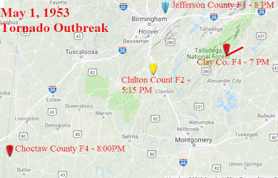
Photo by Crandall McKey, via NWS Huntsville
On May 18, 1995, an F4 tornado struck Limestone and Madison counties in the Tennessee Valley of North Alabama.

To see storm survey data, photos, storm reports, maps, and other data from this event, vistit the NWS Huntsville page here: National Weather Service Huntsville Storm Survey

In 1995, I followed the Anderson Hills tornado through Limestone County. I was one of the first on the scene of a major disaster at a trailer park northeast of Athens. I remember carrying a man out on a door who was bleeding from his neck and chest as I left the scene.

The Anderson Hills Tornado struck Huntsville, Alabama on May 18, 1995, killing one person and causing extensive damage and devastation, including the destruction of the Anderson Hills subdivision. It was rated an F4 when it made a direct hit on the subdivision. The tornado touched down just northwest of Athens. It tracked from that point through eastern Limestone County, through Harvest, Meridianville, and New Market in northern Madison County, Alabama, and ended near Princeton in northwest Jackson County, Alabama. The strongest portion of the tornado's path was near Harvest in northwest Madison County around the Anderson Hills subdivision and the Huntsville Dragway, which is the reason it is usually referred to as the "Anderson Hills Tornado".

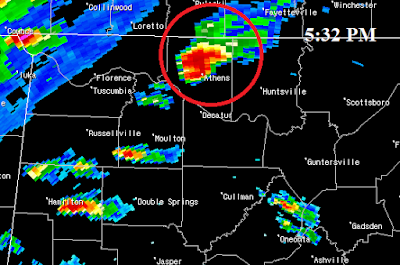
Birmingham NEXRAD, 5:32 p.m., one minute before touch down.
The tornado first touched down at 5:33 p.m. approximately three miles northwest of Athens, just east of Alabama Highway 99. The tornado moved across Alabama Highway 127, then across I-65 near the interchange with U.S. Highway 31. From there, the tornado strengthened as it continued east, crossing Alabama Highway 251, where it destroyed 13 mobile homes at the Oakdale Mobile Home Park. At this point of devastation, one person received major injuries from the tornado and died two days later; Chuck Dale, 30 years of age, was the one fatality of the tornado. Around this time, a Tornado Warning was issued for Madison County to give residents on the northwest side of the county an opportunity to take cover; tornado sirens were activated at 5:43 p.m., one minute after the warning was issued. Meanwhile, the tornado began to move slightly north of east, moving across Mooresville Road and crossing through the Copeland community near the intersection of Copeland Road and East Limestone Road. It continued to strengthen as it crossed over Limestone Creek and approached the Madison County line. Overall in Limestone County, 35 buildings were damaged or destroyed, and 26 mobile homes were destroyed. Around 9,500 customers lost electricity in the county, where damage was estimated to be $1.5 million.

Birmingham NEXRAD, 5:42 p.m., when Madison County Warning was issued
At 5:42 p.m., the NWS Huntsville issued the following warning:

WFUS1 KHSV 182241
TORHSV
ALC089-182345-
BULLETIN - EBS ACTIVATION REQUESTED
TORNADO WARNING
NATIONAL WEATHER SERVICE HUNTSVILLE AL
542 PM CDT THU MAY 18 1995

THE NATIONAL WEATHER SERVICE IN HUNTSVILLE HAS ISSUED A
TORNADO WARNING EFFECTIVE UNTIL 645 PM CDT
FOR PEOPLE IN THE FOLLOWING LOCATIONS...

IN NORTH ALABAMA

...MADISON COUNTY

AT 535 PM CDT RADAR AT THE NATIONAL WEATHER SERVICE OFFICE IN HUNSVILLE
INDICATED A SEVERE THUNDERSTORM OVER WESTERN LIMESTONE COUNTY NEAR ELKMONT.

THIS STORM IS MOVING TO THE EAST AT AROUND 40 MILES PER HOUR.

...POSSIBLE FUNNEL CLOUDS SITED NORTH OF ATHENS IN LIMESTONE COUNTY.

The tornado crossed into Madison County around 5:50 p.m. on Love Branch Road, just north of the Yarborough Road intersection. It continued an east-northeasterly path across Carroll Road, Old Railroad Bed Road, and Wall Triana Highway, crossing just south of Harvest Elementary School. At 5:52 p.m., Madison County Fire dispatch reported that the tornado was on the ground near Harvest. It crossed Fords Chapel Road before taking a direct hit on the Anderson Hills subdivision along Alabama Highway 53. At this point, the tornado was at F4 intensity and the subsequent survey would also reveal evidence of it having multiple vortices. A total of 39 well-constructed houses in the subdivision sustained major damage, and 21 were destroyed. The Piggly Wiggly along Highway 53 also received damage. At 5:54 p.m., the Madison County Sheriff's Department confirmed the tornado had crossed Old Railroad Bed Road and Alabama Highway 53. As a result of these reports, tornado sirens were reactivated in Madison County one minute later. The tornado continued east-northeast making a glancing blow to the Huntsville Dragway before crossing Quarter Mountain Road and Bollweevil Lane on the northern face of Quarter Mountain. Next it crossed Hammond Lane (where is caused major damage to a few two story brick homes), Beaver Dam Road, Beaverdam Creek, and Pulaski Pike. It moved over Beaverdam Creek a second time at Mount Lebanon Road as it moved into the Meridianville area, then across Patterson Lane. Shortly after 6:00 p.m., the tornado crossed U.S. Highway 231/431 at Steger Curve - around Brier Fork bridge. Here, substantial damage was done to a cotton gin and a large farm house was spun off its foundation.

Video showing regional radar loop:


WHNT News 19 Huntsville report on how one family survived:


Sources:
NWS Huntsville
WHNT News 19
Wikipedia
First-hand account

Tuesday, May 01, 2018

May Day Tornado Outbreak - 5/1/1953

1953 was a bad year for killer tornadoes in the United States and Alabama was not immune. The nationwide death toll in 1953 was 519 and in Alabama it was 24. Tornadoes killed one Alabamian on February 20, 1953 and fourteen on April 18, 1953.  The spring tornado season was not over, though, and nine were killed and seventeen injured in the state on Friday May 1, 1953.


May 2, 1953 Florence Times

The May 1, 1953 outbreak included two tornadoes which were considered to be F4 intensity. Officially there were four documented tornadoes in the state that day.  But without the ability to detect and confirm smaller tornadoes especially in rural areas that we have today, it would not be surprising if there were additional tornadoes which were not documented. 

Map of 5/1/1953 Tornadoes

Tornado #1 - Chilton County F2 - 5:15 p.m.
This tornado was on the ground for 1 1/2 miles and was about 100 yards wide in the Minooka community, five miles south of Calera and six miles north of Jemison, in northern Chilton County.  One person was injured, five homes were damaged, and six barns were destroyed.  Fortunately there were no fatalities.

According to the May 2, 1953 Florence (Alabama) Times, "Two awed Highway Patrol officers saw a tornado appear near Calera, 33 miles south of Birmingham. 'We watched it form and begin to pick things up, related W.L. Allen. When it got too close to us, we ran like hell.'  A negro mother and child were injured and four or five homes were leveled in this section before the raging winds bounded toward the east....Old highway 31 south of Calera was blocked for a time by fallen trees and power lines. Traffic was halted until the road could be cleared."  


Tornado #2 - Clay County F4 - 7:30 p.m.
This tornado was on the ground for 12.1 miles and was 440 yards wide in the Millerville-Lineville area. Seven people died and twelve were injured in this storm.  According to the NWS Birmingham tornado database, 19 homes were destroyed, 50 homes were damaged, 36 other buildings were destroyed, and 57 other buildings were damaged. "Numerous chickens were killed and stripped of their feathers," according to the NWS report. 


A user on the Tornado History Project website made this comment about the tornado, "Although it occurred three years before my birth, I often heard my parents speak of this storm. Late in the evening at dark while frying fish with another couple, my mother (who was pregnant with my older brother) heard an all too familiar roar much like she heard on March 21, 1932 as her home was destroyed in Paint Rock, Alabama. The others insisted that it was a train, but Mom insisted that it was a tornado. "Once you hear that sound, you never forget it." They stepped outside to look around and the funnel was less that two blocks away. Dad described it as a slender wedge with much debris aloft, the base of the funnel gyrating in a looping fashion. They jumped into the car to outrun it, but noticed it was moving away from them. Their perspective would have been on State Highway 49 just south of Lineville but north of the tornado's path. Dad was the local dentist and spent that night at the hospital in nearby Ashland helping treat victims of the storm. I am very thankful they didn't pursue outrunning the tornado, especially at dark! Strangly, this storm occurred at the same time as the Paint Rock Tornado."

According to the May 2, 1953 Florence (Alabama) Times, "The storm smashed upon a cluster of homes near Ashland just as night fell, killing seven persons in three family groups. The blasting winds and accompanying lightning storm knocked out all electric power at Ashland. The first injured brought to the tiny Clay County Hospital were treated by candlelight....the Clay County Hospital reported treating 10 persons."


Tornado #3 - Jefferson County F1 - 8:00 p.m.
This small tornado briefly touched down in Trussville and was only on the ground for 1/10th of a mile and was reportedly only 10 yards wide.  No one was injured or killed, but according to the NWS tornado database five homes and one other building were destroyed and one other building was damaged.

Tornado #4 - Choctaw County F4 - 8:00 p.m.
On the ground for 10 miles and 200 yards wide, this tornado was responsible for the deaths of two people and injuries to three others in the Riderwood, Lisman, and Yantley communities.  According to the NWS Birmingham, two homes were "disintegrated" at Yantley and the debris was thrown over a half mile.

Sources:

NWS Birmingham - Alabama Tornado Database - 1953
"The Deadly Tornado Year of 1953" - Alabamawx.com, by Bill Murray
Tornado History Project
Florence Times - May 2, 1953

---
Newer Posts Older Posts Home