I was invited, along with several ABC 33/40 Skywatchers, to attend a radar seminar at the National Weather Service in Birmingham on Saturday June 23, 2012. Meteorologist Kevin Laws, Science Operations Officer for the NWS Birmingham, conducted the training.
Below are my notes from the seminar.
---
Radar is a very complex machine from a mechanical and engineering standpoint. Radar is an “active sensor” of energy. By “active sensor” we mean that it sends out a signal and waits for a return.
There are categories of weather radars. There is no such thing as a “best” radar, they all just have different applications.
1. S-Band (10 cm) radar. Example: (NWS Nexrad Doppler Radar)
2. C-Band (5 cm) radar. Example: (Terminal doppler radars)
3. X-Band (3 cm) radar. Example: (DOW, mobile Doppler radars).
NWS Doppler (WSR) radar objective is to survey and cover broad areas up to 250 nautical miles. WSR stands for “Weather Surveillance Radar”.
C-Band has better resolution that S-Band radars but the surveillance range is much less.
X-Band has the highest resolution but range is the lowest. These 10 mm radars can “see” targets that are 1 mm in size. Some radiation returns from the target, some scatters, some is absorbed, and some goes through the target. S-bands have less attenuation than X and C bands.
Radar equation:
is received power, is transmitted power, is the gain of the transmitting antenna, is radar wavelength, is the radar cross section of the target and is the distance from transmitter to target.
Power of the return is measured in decibels (dBZ).
Doppler radar was introduced in 1942. Wind speed is measured by comparing the angles on the wavelength that the returns are coming back from on consecutive pulses. For example, if the first pulse came back at 0 degrees and the second pulse came back at 90 degrees, the radar “sees” that the target has moved from 0 to 90. Radars can only measure angles between 0 and 180 degrees, limiting the maximum “measureable” wind speed to 58 knots at 180 degree differences. Once wind speed exceeds 58 knots, the angle measurement starts going down from 180. This maximum velocity that can be correctly displayed by a Doppler radar is known as the Nyquist velocity.
By sending out more frequent pulses, the ability to measure higher velocities is possible. However, due to the decreased “listening” time between the more frequent pulses, the effective range is reduced significantly. This is known as the “Doppler Dilemma”.
In order to suit the needs of the meteorologist during different weather conditions, NWS WSR-88 Doppler radars have nine available Volume Coverage Patterns (VCP). Each VCP has a predefined set of instructions given to the antenna that control the rotation speed, pulse and listening time, and elevation angles. The longer listening time is better for reflectivity, but worse for accuracy. Some of these VCP’s enhance the measurement of velocity (VCP 212). Clear air mode VCPs of 31 and 32 are used when velocity is not a concern.
Dual Pol. Single pol radar cannot distinguish between the size of objects within the target area. For example, a target area may contain 700 1 mm raindrops (drizzle) or one 300 mm raindrop. Since those reflectivities are equal, they appear the same on the radar display. Dual pol radar can help distinguish between these targets. Single pol radar looks horizontally only. As a result it doesn’t distinguish well between the size of the objects causing reflectivity. Dual pol, looks at a vertical cross section in addition to the horizontal. This additional data can be compared. As a result, meteorologists can obtain a good idea of the size of the objects being reflected. This, in turn, enhances the ability to distinguish between precipitation types.
One of the dual pol products is ZDR, or differential reflectivity. Hail has a differential reflectivity of around zero. This is measured by subtracting the horizontal dBZ value from the vertical dBZ. When looking at radar products, if you see an area of high dBZ (i.e. 61)on reflectivity and a corresponding low (0) ZDR, the precipitation is hail.
Correlation coefficient (CC) indicates how similarly sized the objects in the target are. This helps indicate where there are areas of mixed precipitation or hail.
“Three body scattered spike” or 3BSS. This refers to an “artifact” that can occur on radar that is caused by large hail. When the wave intersects hail, it is reflected back and also reflected down to the ground. If the ground is wet it is sometimes reflected back to the hail and back again to the radar. This is displayed as a weak echo region that resembles a “spike” protruding from the part of the thunderstorm producing large hail. While many “artifacts” or anomalies on radar are problematic, some, such as the 3BSS can actually be beneficial to the meteorologist.
Future of radar will be phased array radar. The phased array radar is able to scan a variety of pre determined targets which will provide a real time “movie” of a storm system.
GR data: Level 2 vs. Level 3 – Level 2 data is raw data (reflectivity, velocity, spectrum width).
Level 3 data includes processed data from the NWS. In addition to the raw data, it includes SRV, VIL, Mesos, and TVS. Level two radar software from weather vendors may include processed data, it is not the same processed data as the Level 3 NWS data.
Velocity aliasing and folding can be a problem in data provided by level two images provided by vendors. Since the max velocity is 58, the doppler display sometimes shows “couplets” that are nor “real” It also may mask real couplets. Kevin Laws showed examples of various broadcast meteorologists using bad images from their vendor data and compared it to the valid NWS data.
Changes to Gibson Ridge GR3 version 2…
There is a button to pres too “de-alias” velocity data but the three main changes were the Google Earth map background option, Dual pol data (ZDR, CC, HCA, and KDP), and changes to the color scale.
An excellent site to get additional training online is the Warning Decision Training Branch website… http://www.wdtb.noaa.gov/courses/dualpol/
The NCDC archives level 2 data from previous weather events.
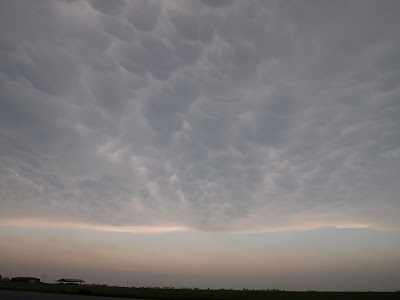
 To some, that title is an oxymoron. But it doesn’t have to be that way. News reports from the Plains since Saturday’s tornado outbreak indicate that in some areas at least, storm chasing has gotten out of hand. In an article in the Salina, KS Journal, Dickenson County, Kansas EMA Director Chancy Smith said that chasers were clogging roads, failing to yield to emergency vehicles, and driving over downed power lines. Over the past twenty years or so, storm chasing has evolved from a relatively small tight-knit group of scientists and spotters to a virtual free-for-all which includes thrill-seekers, adrenaline junkies, publicity hounds, and people wanting to make a quick buck. A “perfect-storm” of events has contributed to this phenomenon. I think the movie “Twister” started the ball rolling. Then, with the proliferation of home video cameras, smart phones, and social media, over time the face of “storm chasing” has changed. Sadly, the change has been for the worse in many ways.


 I spoke with chase partner John Brown about his plans and what he was seeing in the model output. I also spoke to Meteorologist Barry Britnell, Jennifer New, and Carrie Rumbo about posting on my Facebook weather page and communication while I was in the field. Earlier in the week I had spoken with Sarah Vines about chasing with me. It became apparent that there could be two waves of severe weather, one in the morning and one in the afternoon. I actually only got one or two hours of sleep overnight Thursday.
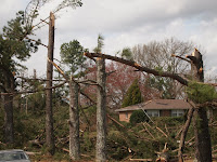 We decided to drive to Buckhorn High School to look at the damage there. We parked there and walked around. There was significant damage to two homes near the school, numerous large trees uprooted and snapped, and a large concrete power pole was blown over. Amazingly, a mobile home was virtually untouched despite the fact it was surrounded by all of this other damage. After walking around the area, we got back in the car to prepare for the rest of the day. I posted some damage photos on my blog and sent live video out of the damage. I saw Andy Kula, Meteorologist with the NWS Huntsville arrive on the scene. He and another NWS employee were already out doing a storm survey. Those folks at the NWS Huntsville are really on top of things! We also had a chance to speak with WHNT 19 Chief Meteorologist Jason Simpson about the afternoon weather and chase plans. At this time there were only a few showers developing in West Alabama. Temperatures had risen to near 80 degrees. Our thoughts at that time were to head back toward the area where I-65 and I-565 intersect. I also spoke to John Brown who was now on I-65 driving north. He decided to stop in Cullman. After spending a little more time at Buckhorn High School, we drove west on Winchester Road back toward U.S. 231 (Memorial Parkway).
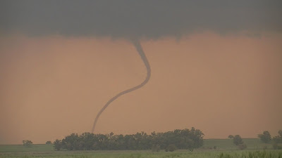
 By the time we got to the Parkway, storms were rapidly intensifying in Northwest Alabama. Instead of driving southwest toward I-65 and I-565, I decided that we should drive north on US 231 toward the Alabama – Tennessee state line so that we could intercept storms that would be moving in that direction. That was a good call, because we would see three separate tornado-warned storms between 2 and 4 p.m. in southern Lincoln County Tennessee and northern Madison County. The first storm we witnessed from U.S. 231, just north of the state line in Tennessee. This storm produced some amazing features, including a rotating wall cloud, cloud to ground lightning from the wall cloud, a possible funnel cloud, and a very large and well-defined “beaver tail”. As we followed this storm east on highway 275 in southern Lincoln County, we were able to see a second tornado-warned storm follow on the heels of the first one. The wall cloud was not as impressive from our vantage point on the second one. Sarah did an excellent job relaying these reports via ham radio and to various sources back at WHNT. WHNT meteorologists Jason Simpson, Ben Smith, and Brandon Chambers provided extensive coverage of these storms. They frequently used our live stream along with radar to describe what was happening in the storms. I also did a phone interview with Jason, describing what we were seeing.
 Meanwhile, storms continued to develop in some of the same areas in Northwest Alabama. A severe storm moved out of Colbert and Lauderdale counties and was moving into Limestone. This storm showed signs of rotation and large hail. We decided to drive a little south on U.S. 231 near Hazel Green to cover this storm. I think I was initially a little too far north. We had a good view, though, of a wall cloud. As it approached, it had the appearance that it was possibly producing a rain-wrapped tornado. We reported it as such; “possible” being the key word. I decided we needed to play it safe and drive south. As we were doing that we experienced quarter-sized hail. It was a good decision to drive south. If the storm had produced a tornado, our original position would have not been safe at all. That is why it is always good to keep watching the sky and always have an escape route. Of course, ideally, it would have been better if we had been further south all along. After the storm passed we drove up and down 231 and saw no damage. Other than snacks and doughnuts, we still had not had a chance to eat. We had even stopped at the McDonald’s drive thru twice in Hazel Green. Both times we gave up on them because the line was long and the service was slow.
 access in time to see storms. We considered going further north to intercept a storm in Tennessee. Then we considered intercepting a storm near Arab. Stopping to eat, traffic, and a train in Huntsville made that impossible. We finally decided to drive to Falkville in Morgan County. There we saw several strong thunderstorms move through which produced an amazing lightning show after the sunset. Photographing lightning after dark is always a great way to end a successful day of chasing. I drove back to Huntsville to take Sarah to her car.
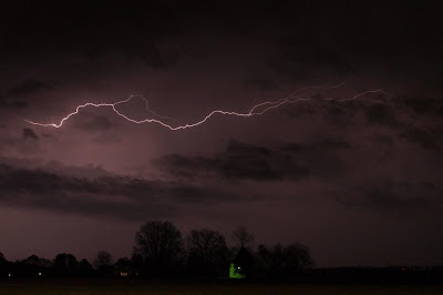


Showers End This Morning; Great Weather on Sunday to End the Weekend - Showers end this morning which will leave us with nice weather for Sunday through Tuesday. We'll get a brief cool down on Wednesday before temperatures war...
5 hours ago


