Significant Tornado Parameter, NAM, Valid 9 p.m. Thursday
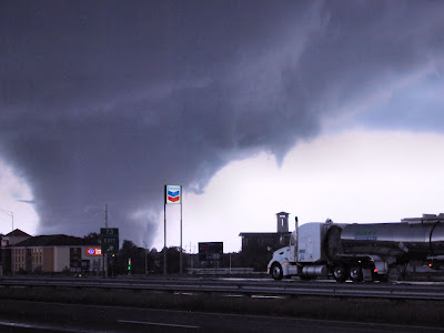
During the past 24 hours there has been quite a bit of talk about the "Significant Tornado Parameter" (STP) index. Understandably, ever since the tragedy of April 27, 2011, residents of Alabama are as concerned about severe weather as they have ever been. Many meteorologists, weather geeks, and friends who are not usually interested in the weather have been posing and reposting a graphic on Facebook showing the NAM computer model output for the STP values for Thursday night and Friday. I think this is a good time to talk about what the Significant Tornado Parameter (STP) represents.
Before attempting to define the STP, we need to start with the broader subject of computer models. There are a variety of computer models that are used by meteorologists to aid in the making of forecasts. The computer models are based on the idea that mathematical equations can describe the changes that govern the weather. As the amount of weather data has increased and as computer technology has advanced, models have become more accurate, sophisticated, and detailed over time.
Computer models have been used to help us gain insight into numerous weather variables. These include the obvious (temperature and precipitation) and many which are less understood by the general public (instability and shear). Meteorologists have learned that there are many variables that play a role bringing about severe weather. When all (or most) of these variables come together, experience has shown that severe weather is more likely.
There are several very specific things that need to happen in the atmosphere for the most violent form of severe weather, the tornado, to be possible. Some of these include: a strong low pressure system, a boundary between air masses, wind shear, a strong jet stream, divergent winds aloft which help provide lifting necessary for updrafts, and instability. Just because these things occur does not guarantee a tornado will form. But meteorologists have a good general idea of the atmospheric conditions that make the formation of tornadoes more likely. This knowledge, along with the ability of computer models to project these conditions several days in advance, aids in our ability to plan and prepare for severe weather events.
While models project each of these ingredients individually, there have been several "composite indices" developed which group these ingredients together. One of these indices is "Significant Tornado Parameter" (STP). The STP is calculated including five ingredients: shear, storm-relative helicity, CAPE, LCL height, and CIN. These terms do not mean anything to over 99 percent of the population. For a more detailed explanation of what these parameters mean, there are several sites online that can help. A technical explanation of the STP can be found here. A very good site that I think puts these terms into language most of us lay people can understand can be found here.
The thing to remember is that models are not infallible, by any means. Models have been created to provide meteorologists with guidance in creating forecasts. Meteorologists determine over time which models perform better in certain circumstances. All models do not provide the same guidance. When using models, forecasters look for consistency over time, consistency between models, historical performance of models, resolution of the model, and how far into the future they are looking. When consistency has been high and the forecast is in the short-term, the forecaster can place a higher level of confidence in the model output. When there is inconsistency and the forecast is long-term, it is unwise to put as much faith in model output.
That brings us back to the severe weather outlook for Thursday night and Friday here in Alabama. Yesterday (Monday) afternoon, the NAM model's STP showed some very high values over North Alabama. This was the first model run where this appeared. It was also about three and one-half days before the potential event. Other models were not showing the same high STP values. So, what should we take from this? What I take from it is that we need to watch model output closely between now and Friday. We need to see if models are consistent with this. What we do not need to do is panic or assume that a major tornado outbreak is a given. A lot can happen in the atmosphere between now and Friday. As it does, the models will adjust accordingly. Even though the NAM is getting a lot of attention, as of Tuesday evening the GFS is still not showing nearly as much potential for a tornado outbreak. I always look for limiting factors as well. I see several factors that could limit this event. The surface low is projected to be way up in the Great Lakes, surface dewpoints are projected to only get as high as the upper 50's in the Tennessee Valley, storms and rain on Wednesday may limit instability, and the surface winds are projected to be out of the southwest, not the southeast, as you would expect to see for a major tornado outbreak. Does that mean we will not see severe weather? No! But unless the trends change, I'm seeing this more as a squall line or QLCS-type event with possibly a few isolated tornadoes. Regardless, this is a situation that needs to be monitored.
I highly recommend that you find a trusted source of weather information as the week goes along. Visit the NWS Huntsville and NWS Birmingham web sites. Read the forecast "discussions" where meteorologists go into a bit more detail about their forecasts. Read the Hazardous Weather Outlooks. Alabama is also blessed to have some excellent broadcast meteorologists. I listen closely to chief meteorologists James Spann (ABC 33/40 in Birmingham) and Jason Simpson (WHNT 19 in Huntsville). The blog
Alabamawx.com is a great source.
This is Severe Weather Awareness Week in Alabama. Please make sure your family, school, business, and church have an action plan should a warning be issued.
...