To some, that title is an oxymoron. But it doesn’t have to be that way. News reports from the Plains since Saturday’s tornado outbreak indicate that in some areas at least, storm chasing has gotten out of hand. In an article in the Salina, KS Journal, Dickenson County, Kansas EMA Director Chancy Smith said that chasers were clogging roads, failing to yield to emergency vehicles, and driving over downed power lines. Over the past twenty years or so, storm chasing has evolved from a relatively small tight-knit group of scientists and spotters to a virtual free-for-all which includes thrill-seekers, adrenaline junkies, publicity hounds, and people wanting to make a quick buck. A “perfect-storm” of events has contributed to this phenomenon. I think the movie “Twister” started the ball rolling. Then, with the proliferation of home video cameras, smart phones, and social media, over time the face of “storm chasing” has changed. Sadly, the change has been for the worse in many ways.
This is not to question the motives of all storm chasers by any means. I have friends in the chaser community who seem to be in it for the right reasons, such as to serve the interests of public safety and science. There is certainly nothing wrong with chasing for the opportunity to learn about and witness nature or to shoot amazing photos or videos to document storms. Few will ever make money by chasing. The expenses outweigh the earning potential. I don’t even have a problem with someone trying to make a few dollars to help defray costs. I think the problems arise when the motive of 15 minutes of “fame” outweighs the interest of serving the public and doing so in a safe way.
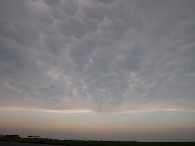
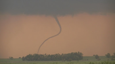
There is an inherent risk involved in storm “chasing”. There is no way around that fact. Driving carries its own risks, even under ideal conditions. Throw in wet roads and high wind and it becomes more dangerous. Obviously the safest scenario is to be as far away from tornadoes, thunderstorms, and flooding as possible. Frankly, I am more concerned about the possibility of being struck by lightning than by a tornado.
These risks can certainly be minimized by following some basic rules. Chuck Doswell has authored the best paper I have read on chaser safety, courtesy, and responsibility. He outlines three primary risks to chasers: driving, lightning, and the actual storm itself. I have read this at least once a year for the past few years and I wish everyone who considers chasing in any way would do likewise. He talks about the importance of driving safely, having a partner, looking out for standing water in the road, pulling far enough off the road, avoiding cities, and many other factors related to driving. He also talks about lightning safety which is the second greatest threat. Finally he talks about the storm itself; tornadoes, high winds, hail, and flooding. For those who are trained storm spotters, the storm should be the least dangerous aspect of chasing.
Safe chasing means you are well prepared, you have an escape route, you do not take unnecessary chances, and you drive carefully. Pull off main roads or at least off the shoulder if the terrain allows or in a parking lot. Learn all you can about storms before you begin chasing. Avoid core-punching! It is better not to chase alone.
If you are new to storm spotting and chasing I highly recommend that you start with storm spotter training with the National Weather Service. I also recommend that you find an experienced chaser to ride along with before you consider going out on your own. Remember, even those of us who have done this for many years can, and have made mistakes. Even though I have attended NWS storm spotter training and numerous other weather conferences, along with a great deal of reading, I still am not above going back to basic training every year. This February I attended NWS storm spotter training provided by the NWS Huntsville. There is always more to learn and be reminded about every time I attend.