Sunday, August 31, 2008

Where will Gustav make landfall?


This is my own map showing projected landfall and greatest risk of storm surge.

It is now getting close enough to the time that Gustav will make landfall to take the models more seriously as far as pinpointing a location.

The NHC is expecting landfall tomorrow around midday.

I should emphasize that the exact point of landfall is still uncertain and people outside that point will still experience hazardous weather conditions.

Below is what the models and the NHC are saying.


NHC forecast as of 7 p.m.


Model "spaghetti plot" as of 7 p.m. I added the bold red lines.


The areas in purple have the greatest likelihood of storm surge,
according to the NHC.


10:16 p.m. NOLA Nexrad


Webcam from Houma, Louisiana:

7 p.m. update....more to come...


Position: 175 SSE of the Mouth of the Mississippi River
Movement: NW at 17 MPH
Winds: 115 MPH
Category: 3
Pressure: 952 MB

Excerpts from the NHC 4 p.m. discussion

GUSTAV IS GETTING A LITTLE BETTER ORGANIZED...WITH A HINT OF
AN EYE RETURNING.

GUSTAV REMAINS IN ABOUT 20 KT OF SOUTHERLY SHEAR...WITH A LOT OF
MID/UPPER-LEVEL DRY AIR SEEN IN WATER VAPOR IMAGERY SOUTH AND WEST
OF THE CYCLONE.

THE INTENSITY FORECAST CALLS FOR WINDS TO INCREASE TO 110 KT
BEFORE LANDFALL...WITH GUSTAV MAKING LANDFALL AS A MAJOR HURRICANE.


4 p.m. CT update on Gustav

MOVEMENT TOWARD NORTHWEST NEAR 18 MPH. MAXIMUM
SUSTAINED WINDS…115 MPH. MINIMUM CENTRAL PRESSURE
…957 MB.
SOME RE-INTENSIFICATION IS POSSIBLE TONIGHT.


I have zoomed in on the model ouput graphics.
There is a strong consensus that landfall will be
on the Louisiana coast, probably west of New
Orleans.

God bless the people of Louisiana

I am really glad to hear that this time around the governing officials and people of Louisiana seem to be taking Gustav seriously and evacuating rapidly.

Let us keep them in our thoughts and prayers.

This is not weather-related, but I dedicate this song to our friends from Louisiana.

From NWS Mobile / NHC


HURRICANE GUSTAV LOCAL STATEMENT
NATIONAL WEATHER SERVICE MOBILE AL
219 PM CDT SUN AUG 31 2008

...GUSTAV WEAKENS A LITTLE MORE...BUT STILL A MAJOR HURRICANE...

...HURRICANE WARNING IN EFFECT FOR MOBILE AND BALDWIN COUNTIES AS
WELL AS THE ADJACENT GULF COASTAL WATERS OF ALABAMA...

...TROPICAL STORM WARNING IN EFFECT FOR THE WESTERN FLORIDA
PANHANDLE AS WELL AS THE ADJACENT GULF COASTAL WATERS OF
NORTHWEST FLORIDA...

...TROPICAL STORM WIND WARNING REMAINS IN EFFECT FOR STONE...
GEORGE... GREENE...PERRY AND WAYNE COUNTIES OF SOUTHEAST
MISSISSIPPI AND WASHINGTON COUNTY OF SOUTHWEST ALABAMA...

...A FLASH FLOOD WATCH IS IN EFFECT ON MONDAY AND TUESDAY FOR EXPECTED
HEAVY RAINS OVER PORTIONS OF SOUTHEAST MISSISSIPPI AND SOUTHWEST
ALABAMA...

AT 100 PM CDT...THE CENTER OF HURRICANE GUSTAV WAS LOCATED ABOUT 270 MILES
SOUTHEAST OF THE MOUTH OF THE MISSISSIPPI RIVER.

GUSTAV IS MOVING TOWARD THE NORTHWEST NEAR 17 MPH. THIS GENERAL
MOTION IS EXPECTED TO CONTINUE WITH A DECREASE IN FORWARD SPEED
DURING THE NEXT COUPLE OF DAYS. ON THIS TRACK...GUSTAV SHOULD MAKE
LANDFALL ON THE NORTHERN GULF COAST ON MONDAY.

REPORTS FROM AN AIR FORCE RESERVE HURRICANE HUNTER AIRCRAFT INDICATE
MAXIMUM SUSTAINED WINDS HAVE TO DECREASED TO NEAR 115 MPH...WITH
HIGHER GUSTS. GUSTAV REMAINS A CATEGORY THREE HURRICANE ON THE
SAFFIR-SIMPSON SCALE. SOME RE-INTENSIFICATION IS FORECAST DURING THE
NEXT 12 TO 24 HOURS...AND GUSTAV COULD REGAIN CATEGORY FOUR STRENGTH
LATER TODAY OR TONIGHT. FLUCTUATIONS IN STRENGTH ARE LIKELY
THEREAFTER...BUT GUSTAV IS FORECAST TO REMAIN A MAJOR HURRICANE UNTIL
LANDFALL.

GUSTAV IS A LARGE TROPICAL CYCLONE. HURRICANE FORCE WINDS EXTEND
OUTWARD UP TO 50 MILES FROM THE CENTER...AND TROPICAL STORM FORCE
WINDS EXTEND OUTWARD UP TO 200 MILES. NOAA BUOY 42003 RECENTLY
REPORTED 8-MINUTE AVERAGE WINDS OF 60 MPH...WITH A GUST TO 78 MPH.

THE MINIMUM CENTRAL PRESSURE REPORTED BY AN AIR FORCE RESERVE
HURRICANE HUNTER AIRCRAFT IS 960 MB...28.35 INCHES.

Two very good links...

This is the one of best links to Gustav information that I have seen. J.B. Elliott of Alabamawx.com found it. It includes links to several maps and NOLA area traffic cameras. There is another link to a wide variety of information at the bottom of the page.

Another great link is this one which shows all four NOLA television live streams on one page.

A look at sea surface temperatures (SST)


Sea surface temperature and buoy data from Weather Underground

Notice that there is a strip of temperatures in the 85-87 degree range between southwestern Florida and Louisiana. Once Gustav reaches this point of the Gulf, there will be more than enough latent heat energy for him to maintain or even increase in intensity. The only possible inhibiting factors would be if wind shear comes into play or possibly some drier air gets entrained into the circulation. The problem is that if Gustav strengthens at all in the mean time, he will take on greater momentum. Sometimes when hurricanes reach that point they "create" their own environment enough that the effects of low shearing environments are not felt as much as you would normally expect.

Hurricane Warning Cameron, LA to Flora-Bama


Hurricane warnings are in effect from Cameron, LA to the Alabama-Florida border. Winds in Gustav were 125 mph in the most recent advisory from the NHC. They noted that the western tip of Cuba caused Gustav to lose strength more than originally thought.

Some strengthening is possible in the short term. In the longer term, models are in fairly good agreement that Gustav will weaken some due to wind shear and slightly cooler water over the northern Gulf. Confidence in the weakening projection is not high as the models traditionally struggle with intensity forecasts. Confidence has increased that Gustav will continue moving to the northwest and then possibly make a slight turn more to the west.

Gustav will be a dangerous and powerful hurricane as it approaches the northern Gulf Coast.

---
HURRICANE GUSTAV LOCAL STATEMENT
NATIONAL WEATHER SERVICE MOBILE AL
654 AM CDT SUN AUG 31 2008

...HURRICANE WARNING IN EFFECT FOR MOBILE AND BALDWIN COUNTIES AS
WELL AS THE ADJACENT GULF COASTAL WATERS OF ALABAMA...
AT 600 AM CDT...THE CENTER OF HURRICANE GUSTAV WAS LOCATED 
ABOUT 375 MILES SOUTHEAST OF THE MOUTH OF THE MISSISSIPPI RIVER.

GUSTAV IS MOVING TOWARD THE NORTHWEST NEAR 16 MPH...AND THIS MOTION
IS EXPECTED TO CONTINUE FOR THE NEXT COUPLE OF DAYS WITH SOME
DECREASE IN FORWARD SPEED EXPECTED ON MONDAY. ON THIS TRACK...GUSTAV
WILL BE MOVING ACROSS THE CENTRAL GULF OF MEXICO TODAY...AND MAKE
LANDFALL ON THE NORTHERN GULF COAST ON MONDAY.

REPORTS FROM AIR FORCE RESERVE AND NOAA HURRICANE HUNTER AIRCRAFT
INDICATE THAT MAXIMUM SUSTAINED WINDS HAVE DECREASED TO NEAR 120
MPH WITH HIGHER GUSTS. GUSTAV IS A CATEGORY THREE HURRICANE ON THE
SAFFIR-SIMPSON SCALE. SOME RESTRENGTHENING IS FORECAST DURING THE
NEXT 24 HOURS...AND GUSTAV COULD REGAIN CATEGORY FOUR STRENGTH LATER
TODAY OR TONIGHT.


Saturday, August 30, 2008

Update at 7 p.m. - Excerpt from the NHC

BULLETIN
HURRICANE GUSTAV INTERMEDIATE ADVISORY NUMBER 25A
NWS TPC/NATIONAL HURRICANE CENTER MIAMI FL AL072008
800 PM EDT SAT AUG 30 2008

...GUSTAV MAKES LANDFALL IN WESTERN MAINLAND CUBA...

A HURRICANE WATCH REMAINS IN EFFECT FOR THE NORTHERN GULF COAST FROM
EAST OF HIGH ISLAND TEXAS EASTWARD TO THE ALABAMA-FLORIDA BORDER...
INCLUDING THE CITY OF NEW ORLEANS AND LAKE PONTCHARTRAIN. A
HURRICANE WATCH MEANS THAT HURRICANE CONDITIONS ARE POSSIBLE WITHIN
THE WATCH AREA...GENERALLY WITHIN 36 HOURS.

A TROPICAL STORM WATCH REMAINS IN EFFECT ALONG THE PANHANDLE COAST
OF FLORIDA FROM EAST OF THE ALABAMA-FLORIDA BORDER EASTWARD TO THE
OCHLOCKONEE RIVER. A TROPICAL STORM WATCH MEANS THAT TROPICAL
STORM CONDITIONS ARE POSSIBLE WITHIN THE WATCH AREA...GENERALLY
WITHIN 36 HOURS.

AT 800 PM EDT...0000Z...THE EYE OF HURRICANE GUSTAV WAS LOCATED
NEAR LATITUDE 22.7 NORTH...LONGITUDE 83.4 WEST. THIS POSITION IS
OVER WESTERN CUBA NEAR LOS PALACIOS AND ABOUT 65 MILES...105 KM...
WEST-SOUTHWEST OF HAVANA. DO NOT VENTURE OUTSIDE DURING THE
PASSAGE OF THE EYE...SINCE WINDS WILL SOON RAPIDLY INCREASE AS
EYEWALL AGAIN PASSES. THE EYE IS ALSO CURRENTLY CENTERED ABOUT 570
MILES...915 KM...SOUTHEAST OF THE NORTH-CENTRAL
GULF OF MEXICO COAST.

GUSTAV IS MOVING TOWARD THE NORTHWEST NEAR 15 MPH...24 KM/HR...AND
THIS GENERAL MOTION IS EXPECTED TO CONTINUE DURING THE NEXT COUPLE
OF DAYS. ON THIS TRACK...THE CENTER OF GUSTAV WILL EMERGE INTO THE
SOUTHEASTERN GULF OF MEXICO DURING THE NEXT FEW HOURS...AND REACH
THE NORTHERN GULF ON MONDAY.

MAXIMUM SUSTAINED WINDS REMAIN NEAR 150 MPH...240 KM/HR...WITH
HIGHER GUSTS. GUSTAV IS AN EXTREMELY DANGEROUS CATEGORY FOUR
HURRICANE ON THE SAFFIR-SIMPSON HURRICANE SCALE. THERE ARE
UNOFFICIAL REPORTS FROM PINAR DEL RIO PROVINCE OF WINDS NEAR THESE
ESTIMATES. SOME FLUCTUATIONS WITH AN OVERALL SLIGHT STRENGTHENING
IS FORECAST DURING THE NEXT 24 HOURS...AND GUSTAV COULD REACH
CATEGORY FIVE INTENSITY DURING THIS PERIOD. GUSTAV IS FORECAST TO
REMAIN A MAJOR HURRICANE THROUGH LANDFALL ALONG THE NORTHERN GULF
COAST.

HURRICANE FORCE WINDS EXTEND OUTWARD UP TO 70 MILES...110 KM...FROM
THE CENTER...AND TROPICAL STORM FORCE WINDS EXTEND OUTWARD UP TO 175
MILES...280 KM.

THE MINIMUM CENTRAL PRESSURE REPORTED BY AN AIR FORCE RESERVE
HURRICANE HUNTER AIRCRAFT AS GUSTAV WAS MAKING LANDFALL WAS 941
MB...27.79 INCHES.

FORECASTER BEVEN

-------------------------

Gustav continues to strengthen...


Latest stats as of 5 p.m. ET: WINDS 150 MPH PRESSURE: 942 MB

Note: An increase of 5 miles per hour will make Gustav a Category 5 hurricane.

---

Gustav approaching Western Cuba


4:15 p.m. ET

Gustav on verge of Cat 5 status


3:15 ET

FEMA: Gustav Soon to Be Category 5

"FEMA officials said Bill Read, the director of the National Hurricane Center, interrupted an afternoon teleconference involving the agency, Gulf Coast states and the National Weather Service to say he is going to issue a special advisory statement raising Gustav to Category 5. That means winds greater than 155 mph and a storm surge greater than 18 feet above normal."

---

Excerpt from NHC Discussion:

HURRICANE GUSTAV SPECIAL DISCUSSION NUMBER 24 NWS TPC/NATIONAL HURRICANE CENTER MIAMI FL AL072008200 PM EDT SAT AUG 30 2008 SO MUCH FOR A SLOWDOWN IN THE INTENSIFICATION RATE OF GUSTAV. YESTERDAY AT THIS TIME WE CONVEYED THAT RAPID INTENSIFICATION OVER THE NORTHWESTERN CARIBBEAN WAS POSSIBLE...BUT THIS IS A LITTLE MORE THAN WHAT WE HAD IN MIND IN SUCH A SHORT TIME. THE HURRICANE HAS REACHED CATEGORY FOUR STATUS WITH AN INTENSITY OF 125 KT...HAVING BEEN A STRONG TROPICAL STORM JUST ABOUT 24 HOURS AGO.

Weather conditions in Cuba this afternoon

3 p.m. ET:

Havana Airport - Heavy Rain - 75F - Winds NE 36/51 - Wx Underground

Nueva Gerona, Isla De Pinos, Cuba - Rain Shower - 78F - Winds ENE 40/52

Varadero, Matanzas, Cuba - Heavy Rain - 75F - Winds Variable 24/41

---

Gustav is now a Category 4 hurricane


1:15 ET Infrared

HURRICANE GUSTAV TROPICAL CYCLONE UPDATE
NWS TPC/NATIONAL HURRICANE CENTER MIAMI FL AL072008
120 PM EDT SAT AUG 30 2008

DATA FROM AN AIR FORCE RECONNAISSANCE AIRCRAFT INDICATE THAT
GUSTAV HAS CONTINUED TO STRENGTHEN AND NOW HAS MAXIMUM WINDS
NEAR 145 MPH…230 KM/HR WITH HIGHER GUSTS. THIS MAKES GUSTAV AN
EXTREMELY DANGEROUS CATEGORY FOUR HURRICANE ON THE SAFFIR-SIMPSON
HURRICANE SCALE. A SPECIAL ADVISORY WILL BE ISSUED AT ABOUT 200 PM
EDT TO MODIFY THE INITIAL AND FORECAST INTENSITIES. THE SPECIAL
PUBLIC ADVISORY WILL TAKE THE PLACE OF THE INTERMEDIATE PUBLIC
ADVISORY PREVIOUSLY SCHEDULED FOR THAT TIME.

$$
FORECASTER KNABB

---

Update as of 2 p.m. ET:

ESTIMATED MINIMUM CENTRAL PRESSURE 945 MB
EYE DIAMETER 30 NM
MAX SUSTAINED WINDS 125 KT WITH GUSTS TO 150 KT.

GUSTAV IS AN EXTREMELY DANGEROUS CATEGORY FOUR
HURRICANE ON THE SAFFIR-SIMPSON HURRICANE SCALE.
AN UNOFFICIAL OBSERVATION OF A SUSTAINED WIND OF
140 MPH...220 KM/HR...HAS BEEN REPORTED ALONG THE
EASTERN COAST OF THE ISLE OF YOUTH.

---
From the AP:

"HAVANA - Gustav swelled into a fearsome Category 4 hurricane with winds of 145 mph (235 kph) on Saturday as Cuba raced to evacuate more than 240,000 people and Americans to the north clogged highways fleeing New Orleans. Gustav already has killed 78 people in the Caribbean..."


Models


Latest take from the models continues to show Gustav making landhfall on the Central Louisiana coast. There are some outliers, especially after 2 days.

Due to the proximity to New Orleans, residents will be evacuated this weekend. Thankfully Mayor Nagin appears determined not to make the same mistake he made three years ago this weekend by hesitating to order evacuations.

Watch live coverage from WDSU New Orleans coverage here.

---

More about Gustav


Cuba radar

Excerpts from the latest NHC discussion:

EYE IS BECOMING VISIBLE AND DEEP CONVECTION SURROUNDING
THE EYE IS NOW VERY INTENSE. THE CENTRAL PRESSURE IS
DOWN TO 965 MB...A DROP OF ABOUT 24 MB IN 24 HOURS.

GUSTAV IS EXPECTED TO BE A LARGE AND DANGEROUS HURRICANE
AND THE NHC FORECAST CONTINUES TO SHOW GUSTAV AS A MAJOR
HURRICANE AT LANDFALL.

Gustav now a major hurricane


Just as predicted yesterday afternoon by the NHC, Gustav rapidly intensified to major hurricane status overninght.

As of 7 a.m. CT Gustav remains in Category 3 status on the Saffir-Simpson Scale, with winds of 120 miles per hour and pressure of 955 mb.

It attained this status just before 5 a.m. CT and was noted in this bulletin:

HURRICANE GUSTAV TROPICAL CYCLONE UPDATE
NWS TPC/NATIONAL HURRICANE CENTER MIAMI FL AL072008
600 AM EDT SAT AUG 30 2008


DATA FROM AN AIR FORCE RECONNAISSANCE AIRCRAFT INDICATE THAT
GUSTAV CONTINUES TO RAPIDLY STRENGTHEN AND NOW HAS MAXIMUM WINDS
NEAR 115 MPH...185 KM/HR WITH HIGHER GUSTS. THIS MAKES GUSTAV A
DANGEROUS CATEGORY THREE HURRICANE ON THE SAFFIR-SIMPSON HURRICANE
SCALE...THE SECOND MAJOR HURRICANE OF THE 2008 ATLANTIC HURRICANE
SEASON.

Latest from the NHC


BULLETIN
HURRICANE GUSTAV INTERMEDIATE ADVISORY NUMBER 21A
NWS TPC/NATIONAL HURRICANE CENTER MIAMI FL AL072008
200 AM EDT SAT AUG 30 2008

...GUSTAV STRENGTHENS...BEARING DOWN ON THE CAYMAN ISLANDS...

MAXIMUM SUSTAINED WINDS...85 MPH.
MINIMUM CENTRAL PRESSURE...971 MB.

---

THUS...THERE IS A
DISTINCT POSSIBILITY OF RAPID INTENSIFICATION IF THE STORM
STRUCTURE AND THE INTERACTION WITH THE TROUGH PERMIT. THE SHIPS
MODEL CALLS FOR A PEAK INTENSITY OF 104 KT...THE LGEM 97 KT...THE
HWRF 114 KT...THE FLORIDA STATE SUPERENSEMBLE 114 KT...AND THE GFDL
129 KT. BASED ON THIS AND THE PREMISE THAT THE INTERACTION WITH
THE TROUGH WILL ALLOW STEADY STRENGTHENING...THE FORECAST PEAK
INTENSITY IS INCREASED TO 115 KT. GUSTAV COULD GET STRONGER THAN
THAT IF RAPID INTENSIFICATION OCCURS. THE INTENSITY FORECAST SHOWS
A SLIGHT WEAKENING AT 72 HR AS GUSTAV REACHES LOWER OCEANIC HEAT
CONTENT AND POSSIBLE ENCOUNTERS SOME WESTERLY SHEAR. HOWEVER...
GUSTAV IS EXPECTED TO MAKE LANDFALL AS A MAJOR HURRICANE.


Friday, August 29, 2008

Hurricane Gustav strengthens, approaches the Caymans


As of 8 p.m. ET the NHC reports that Hurricane Gustav has maximum sustained winds of 80 mph and a minimum central pressure of 975 mb. This makes Gustav a Category One storm.

Gustav is projected to cross over the Cayman Islands tonight and the western tip of Cuba later tomorrow.


The NHC cone of uncertainty shows Gustav making landfall on the US Gulf Coast somewhere between Corpus Christi, Texas and Gulf Shores, Alabama late Monday or Tuesday as a major hurricane.

The NHC noted that:
THE GFS...GFDL...AND HWRF...DO NOT SHOW THE RIDGE EXTENSION NOR
A STRONG UPPER-LEVEL
TROUGH...AND FORECAST GUSTAV TO BE PULLED
INTO THE NORTHERN GULF
COAST FARTHER EAST.


This is significant because these three models usually seem to be more accurate with tropical systems than the models that are showing it further off to the west. Having said that, the 18Z models seem to all be trending to the west, thus decreasing the threat to Alabama and Mississippi.

Obviously all interests in the Gulf states should all stay tuned for the latest on this developing situation.

Preparation tips from Alabama Power

Alabama Power prepares for Gustav, offers tips to customers

From the Montgomery Advertiser:

Alabama Power crews and storm operations personnel are closely watching Gustav as it moves toward the Gulf of Mexico. While it is too early to predict precisely where Gustav will make landfall, the company is making preparations for the possibility the storm will impact Alabama Power territory. Meanwhile, customers should also be making preparations in case the storm hits Alabama.

Before the storm


1. Charge cell phones, pagers and other electronic devices. Use a battery-operated weather radio to stay informed. Have several flashlights with extra batteries on hand, as well as a first-aid kit.

2. Keep a three-day minimum supply of water – one gallon per person per day, plus three days’ supply of food and drink that does not have to be refrigerated.

3. Turn down the thermostat to cool your house. If you keep doors and windows closed after the storm, you can keep your house relatively cool for about 48 hours.

4. Seek shelter inside a sturdy building. In the event of a tornado, the safest place is on the lowest level. Choose a small room with no windows, such as an interior closet, hallway or bathroom.

Gustav batters Caribbean Islands

Gustav now a hurricane!


Much more to report soon. Rapid intensification is underway.

More soon.

HURRICANE GUSTAV TROPICAL CYCLONE UPDATE
NWS TPC/NATIONAL HURRICANE CENTER MIAMI FL AL072008
315 PM EDT FRI AUG 29 2008


DATA FROM AN AIR FORCE RECONNAISSANCE AIRCRAFT INDICATE THAT
GUSTAV HAS AGAIN BECOME A HURRICANE WITH MAXIMUM WINDS NEAR 75
MPH...120 KM/HR.

$$
FORECASTER KNABB

---

Rapid intensification?


The NHC mentioned in their discussion this morning that Gustav could rapidly intensify as it emerges from Jamaica and heads toward western Cuba. This would be due to very warm water and very little verical shear. They even mentioned the possibility of it becoming a Category Four storm as it approaches the Gulf. Either way, I think he will be come a hurricane later this morning or at least by this afternoon.

---

From the Mobile Press-Register

Mobile Press-Register Editorial, August 28, 2008 (Page 8A)

Why preparation matters

Thursday, August 28, 2008

EVEN THOUGH it's tempting to dwell on the unfairness of a hurricane following so closely on the heels of Tropical Storm Fay, Alabamians can't afford to waste the time. They've got work to do.

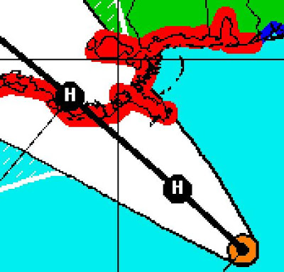
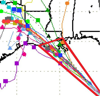
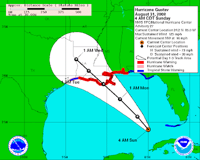
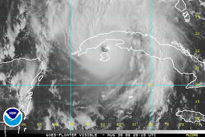
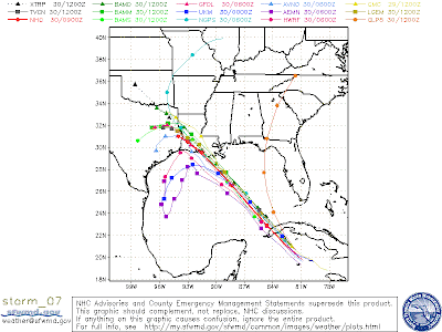
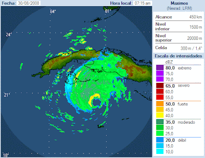
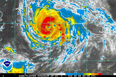
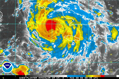
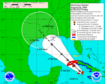
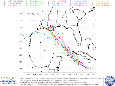
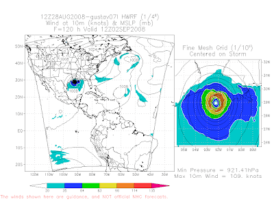
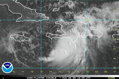
With meteorologists predicting that the new storm, Gustav, will threaten the Gulf Coast as a major hurricane, it's time to review family evacuation plans, emergency supplies and the like.
Perhaps Alabama will get lucky and Gustav will go somewhere else. But the key to effective hurricane preparation does not lie in wishful thinking; it lies in paying attention to weather advisories and emergency planners.

It lies in deciding whether to leave home or "shelter in place," as the experts call staying put in a storm. And, as always, effective preparation lies in people making sure they have necessities such as non-perishable groceries, bottled water, batteries, prescription drugs and pet food.

In keeping with the spirit of preparedness, it was good to hear Gov. Bob Riley say Wednesday that state agencies are making storm plans, too. In addition to keeping an eye on the storm as it prepares to enter the Gulf of Mexico, he said, state officials are in contact with the Federal Emergency Management Agency.

Certainly, the agencies' efforts could turn out to be unnecessary. But it would be beyond reckless not to get ready for a storm that could be at least as powerful as Hurricane Katrina.

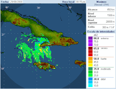
Surely, fresh memories of the damage from Katrina in 2005, and from Hurricane Ivan the year before, will keep Alabamians from taking anything for granted.

Thursday, August 28, 2008

Looking closer at the HWRF Model


NEW ADVANCED HURRICANE MODEL AIDS NOAA FORECASTERS
"June 27, 2007 NOAA’s National Centers for Environmental Prediction and its National Hurricane Center forecasters will now use the Hurricane Weather and Research Forecast Model to predict the track and strength of storms this hurricane season."

Note the HWRF is projecting a strong Cat 3 with maximum sustained winds of 125 miles per hour making landfall in the marshes of the Central Louisiana Coast.

---

Very good discussion on Gustav

Many of my readers will be aware of this, but James Spann's map discussions are an invaluable resource, especially in situations such as the one we have now as Gustav threatens. If you haven't yet, take a few minutes and watch. I have learned a lot watching these almost every day.

Wednesday, August 27, 2008

Better not wait too late....

Bill Murray of Alabamawx.com wrote the best, most timely, and most prophetic weather blog entry ever written, in my humble opinion.

"I am thoroughly amazed at an interview that I just heard with New Orleans Mayor Ray Nagin on WWL radio. He said that he was considering a mandatory evacuation of the city. Considering? With the official National Hurricane Center track showing a Category Four hurricane, perhaps even a Category FIVE hurricane moving directly over a city that takes 72 hours to evacuate? He said that the city's attorneys were in consultation about the legalities of such an order. Legalities? Wouldn't that be something you would contemplate in advance? Not 48 hours before landfall. What would be the criteria that would make such an action automatic?"

Read MORE

---

GFDL output

State of Alabama Government prepares for Gustav


MONTGOMERY - Governor Bob Riley on Wednesday met with the leaders of several state agencies involved in preparations for Tropical Storm Gustav, which is expected to become a hurricane as it enters the Gulf of Mexico.

Pictured in the meeting with the Governor (center) are, to the Governor’s right:

  • Brock Long, Director of the Alabama Emergency Management Agency
  • General A.C. Blalock, Adjutant General of the Alabama National Guard
  • Captain Marc McHenry of the Alabama Department of Public Safety

Pictured to the Governor’s left are:

  • Joe McInnes, Director of the Alabama Department of Transportation
  • Don Vaughn, Deputy Director/Chief Engineer of the Alabama Department of Transportation
  • George Conner, Maintenance Engineer of the Alabama Department of Transportation

Earlier on Wednesday, Governor Riley said state agencies are monitoring the storm closely. He also encouraged Alabamians to take steps now to prepare for the storm.

Gustav is a MAJOR concern


Please take this with a grain of salt; maybe even with half a shaker, but anyway you slice it, the model output by the GFDL model is very disturbing. The GFDL is considered one of the most reliable models in forecasting tropical systems.

The GFDL shows a strong Hurricane Gustav making landfall on the coast of Louisiana, just west of New Orleans around Midnight Sunday night/Monday morning. The GFDL shows the storm will be packing maximum sustained winds of 130 miles per hour and a minimum central pressure of 938 millibars, or 27.70 inches of mercury. That is a top end Category 3 on the Saffir-Simpson Scale. That pressure figure is usually associated with a Category Four hurricane. The GFDL also shows the storm to have winds of 150 miles per hour, which is a high end Category Four about 6 hours prior to landfall.

HUGE disclaimer: This is simply model output. I think that it is reasonable to expect that a strong hurricane will strike the Gulf Coast early next week. The models will likely shift back and forth quite a bit between now and then, however, with regard to intensity and especially location.
To back up the disclaimer, here is an excerpt from this morning's NHC discussion:

THERE IS VERY LITTLE...IF ANY...SKILL ININTENSITY PREDICTIONS AT THESE EXTENDED RANGES. INDEED...IF ONELOOKS AT THE LATEST WIND SPEED PROBABILITY PRODUCT INCLUDED IN THISPACKAGE...IT CAN BE SEEN THAT THERE IS NEARLY AN EQUAL CHANCE THATGUSTAV WILL BE A CATEGORY 1...CATEGORY 2...OR CATEGORY 3 HURRICANEAT THE END OF THE FORECAST PERIOD.

It is very disturbing, though, that the GFDL is painting this picture.

---

Alabama man dies from remnants of Fay

As the remnants of Tropical Storm Fay moved across Alabama on Saturday, a Mobile man drowned in Lake Martin in Elmore County. To my knowledge that was the only death in Alabama resulting from the storm. Here is an article from the Mobile Press-Register.

Other US fatalities from the effects of Fay included eleven in Florida and one in Georgia.

These storms are potentially very dangerous even when they are not monster huricanes.

---

Alabama tornado reports from Sunday and Monday

I have not yet seen any storm survey results from the numerous tornadoes that were reported across the State of Alabama on Sunday August 24 and Monday August 25.

Here are the initial reports from the Storm Prediction Center.

Sunday 8/24 - Two reports.

2:16 p.m. a tornado was reported at Emerald Mountain in Elmore County.

2:16 a tornado was reported near Welona on the Coosa/Elmore line, near the Coosa River.

Monday 8/25 - Eleven reports.

8:05 a.m. unconfirmed tornado damage at Troy State University on Needmore Road.

8:20 four miles west of Skipperville in Dale Co. several trees were down and a barn damaged.

8:25 an F0 reported 4 miles NE of Troy damaged chicken coops and snapped off trees.

11:02 5 miles NNE of Odenville in St Clair trees fell on structures near the state prison.

11:25 6 miles NE Remlap in Blount unconfirmed tornado at Inland Lake damaged a boat launch.

11:56 3NNW Chalafinnee in Cleburne significant damage to gas station and an auto body shop.

12:10 6West Heflin in Calhoun one home sustained significant damage

12:16 5NE Dearmanville in Calhoun auto shop destroyed, two houses mod damage, 50-100 trees
5:55 5SW Monticello in Pike several hardwood trees uprooted and pines snapped

6:26 2SE Gordon in Houston mobile home destroyed in Lucy community.

10:25 4NE Troy in Pike F0.


It will be interesting to see the results of these storm surveys.

---

Storm total rainfall from Fay

Fay went a long way towards reducing the drought conditions in Alabama. I ended up receiving 3.06" of total rainfall from Fay. That was one of the lowest amounts reported across Alabama. We can always count on J.B. Elliott of Alabamawx.com to provide the most comprehensive list of rainfall totals.

Here is an excerpt from J.B.'s list (which I sorted) of the locations he found where at least 8 inches was reported.

15.57 6 miles east of Clayhatchee
12.74 Highland Home
11.62 Valley
10.80 Hoover/Russett Woods
10.54 Inches at Noccalula Falls
10.10 Lake Purdy (Three Cheers!)
10.01 Wetumpka
9.95 Camden (Wilcox County)
9.81 SW Lamar County
9.75 Helena/Old Cahaba
9.55 South Trussville
9.33 Meadow Brook
9.27 Scrougeout, brings the 2008 total to 42.93 (NE Etowah County)
9.15 Clay/Pinsion (Womack Road)
9.07 Greystone Cove (James Spann)
9.02 Huffman (Bob Dietlein–enjoyed working with him 32 years at USWB/NWS)
9.00 Tri County where Blount/Jefferson/St. Clair meet
8.80 Cahaba Heights
8.73 Calera
8.54 NE Trussville/Peppertree…thanks to Bob Alvis
8.25 Altadena
8.17 NE Trussville/Old Mill Run (Miss Molly lives there)
8.14 Troy


It looks like storm totals ranged from 3-15" across the great State of Alabama.

J.B.'s complete list can be found here.

Thank you Lord for the big rain.

---

Tuesday, August 26, 2008

Remnants of Fay


The center of ex-tropical storm Fay moved over my location today. Now on to Gustav.

One model has the thing making landfall just west of New Orleans. I sure hope it doesn't turn into another Katrina or Ivan.

---

Rain from Fay

My storm total as of 7 a.m. was 2.95". I am thankful, but it was not as much as I had hoped for. The highest storm totals so far in Alabama on the CoCoRaHS site were in the 5-7" range.

---

New kid on the block

With all of the trouble that we have had with Fay, there has scarcely been time to discuss the fact that Gustav blew up yesterday and overnight. This time yesterday, Gustav was nothing more than a tropical wave. Now he is a full-fledged hurricane with maximum sustained winds of 90 miles per hour and a minimum central pressure of 984 millibars as of 5 am Eastern Time. In the immortal words of Gomer Pyle, "Shazam!"

In all seriousness, I am extremely concerned about Gustav. He will likely be a powerful hurricane in the southern Gulf of Mexico by Tuesday Morning, directly south of Apalachicola, Florida. Everyone in the Gulf Coast states should start making mental preparations for what could be a nervous week next week. Below is this morning''s discussion from the National Hurricane Center.


HURRICANE GUSTAV DISCUSSION NUMBER   5
NWS TPC/NATIONAL HURRICANE CENTER MIAMI FL AL072008
500 AM EDT TUE AUG 26 2008

GUSTAV HAS CONTINUED TO INTENSIFY DURING THE LATE NIGHT HOURS. AN
AIR FORCE RESERVE RECONNAISSANCE MISSION HAS FOUND FLIGHT-LEVEL
WINDS OF 90 KT...PEAK SFMR SURFACE WINDS OF 76 KT...AND A RECENT
ESTIMATED PRESSURE OF 984 MB. THE INITIAL INTENSITY IS
CONSERVATIVELY RAISED TO 75 KT. SATELLITE IMAGES SHOW AN ORGANIZING
PATTERN WITH A CENTRAL DENSE OVERCAST BECOMING MORE PROMINENT AND
GUSTAV IS LIKELY NOT DONE INTENSIFYING BEFORE IT PASSES OVER
SOUTHWESTERN HAITI LATER TODAY. SOME WEAKENING IS SHOWN IN 24 HR
DUE TO THE LAND INTERACTION WITH HAITI. THEREAFTER...THE HURRICANE
IS FORECAST TO BE OVER EXTREMELY WARM WATERS WITH RELATIVELY LIGHT
SHEAR. THE OFFICIAL INTENSITY FORECAST IS INCREASED AND NOW CALLS
FOR GUSTAV TO BE A MAJOR HURRICANE IN THE NORTHWESTERN CARIBBEAN
SEA. IT IS WORTH NOTING THAT BOTH THE GFDL/HWRF FORECAST SHOW AN
EVEN STRONGER HURRICANE. MOST INDICATIONS ARE THAT GUSTAV WILL BE
AN EXTREMELY DANGEROUS HURRICANE IN THE NORTHWESTERN CARIBBEAN SEA
IN A FEW DAYS.

THE INITIAL MOTION ESTIMATE IS 315/8...THOUGH GUSTAV MAY RECENTLY BE
MOVING A BIT MORE TO THE RIGHT. THE BIGGEST CHANGE TO NOTE THIS
MORNING IS A DRAMATIC SOUTHWESTWARD SHIFT WITH ALMOST ALL GUIDANCE.
A LARGE UPPER TROUGH OVER THE WESTERN ATLANTIC IS EXPECTED TO MOVE
EAST AWAY FROM GUSTAV...LEAVING RIDGING OVER THE BAHAMAS AND
FLORIDA. GLOBAL MODELS HAVE COME INTO MUCH BETTER AGREEMENT THAT
THE HURRICANE WILL TURN TO THE WEST-NORTHWEST OR EVEN WEST IN A DAY
OR SO DUE TO THIS BUILDING RIDGE. THE OFFICIAL FORECAST HAS BEEN
ADJUSTED SOUTHWESTWARD BEYOND 24 HR BUT IS STILL ON THE NORTHERN
EDGE OF THE GUIDANCE ENVELOPE. THE FORECAST COULD HAVE BEEN
SHIFTED EVEN MORE TO THE LEFT BUT WE'D PREFER TO WAIT UNTIL THE
GUIDANCE BECOMES MORE STABLE.

ABC 33/40 coverage of Calhoun County tornado

ABC 33/40 Coverage of the tornado yesterday in Calhoun County

Monday, August 25, 2008

My observations...

Today: Low 69 High 77 Currently 70/66 Rain since midnight 1.25"; Storm total rainfall 2.26" so far here at my location.

Storm total rains from Fay

Date Time Station Number Station Name Total Precip .in5 New Snow .in Total Snow .in State County View
8/25/2008 8:00 AM AL-MB-41 Theodore 8.0 SSE 7.05 0.0 NA AL Mobile View
8/25/2008 6:30 AM AL-BW-3 Daphne 1.2 NNW 6.83 0.0 NA AL Baldwin View
8/24/2008 7:00 AM AL-WX-2 Camden 1.0 NNE 6.50 0.0 NA AL Wilcox View
8/25/2008 7:00 AM AL-MB-15 Theodore 3.9 SSE 6.44 0.0 NA AL Mobile View
8/25/2008 7:00 AM AL-MB-21 Theodore 6.7 SSE 6.30 0.0 NA AL Mobile View
8/24/2008 7:00 AM AL-CB-1 Valley 0.4 NNW 6.11 0.0 NA AL Chambers View
8/24/2008 8:00 AM AL-BK-1 Union Springs 0.2 N 6.10 0.0 NA AL Bullock View
8/24/2008 7:00 AM AL-EL-7 Wetumpka 5.0 SE 6.06 0.0 NA AL Elmore View
8/24/2008 7:00 AM AL-PK-1 Troy 1.5 ESE 5.85 0.0 NA AL Pike View
8/24/2008 8:00 AM AL-BR-1 Clio 0.2 SSW 5.71 0.0 NA AL Barbour View
8/24/2008 7:00 AM AL-CS-3 Alexander City 10.0 SW 5.70 0.0 NA AL Coosa View
8/25/2008 7:00 AM AL-BW-4 Daphne 0.4 SW 5.63 0.0 NA AL Baldwin View
8/24/2008 7:00 AM AL-CS-1 Sylacauga 9.2 S 5.54 0.0 NA AL Coosa View
8/24/2008 8:00 AM AL-RS-3 Ladonia 13.2 SSW 5.52 0.0 NA AL Russell View
8/25/2008 7:00 AM AL-MB-14 Saraland 6.8 NNW 5.44 0.0 NA AL Mobile View
8/25/2008 7:00 AM AL-MB-28 Theodore 3.0 S 5.34 0.0 NA AL Mobile View
8/24/2008 7:00 AM AL-EL-18 Wetumpka 9.9 NNE 5.29 0.0 NA AL Elmore View
8/24/2008 7:00 AM AL-BR-2 Eufaula 1.0 SSE 5.26 0.0 NA AL Barbour View
8/24/2008 6:00 AM AL-SH-27 Pelham 0.7 NNW 5.25 0.0 NA AL Shelby View
8/24/2008 6:15 AM AL-EL-16 Eclectic 5.2 SW 5.10 0.0 NA AL Elmore View
8/24/2008 7:00 AM AL-DL-2 Clopton 0.1 SW 4.94 0.0 NA AL Dale View
8/25/2008 7:00 AM AL-MB-50 Mobile 5.1 S 4.92 0.0 NA AL Mobile View
8/24/2008 6:00 AM AL-WX-1 Pine Hill 3.6 WSW 4.92 0.0 NA AL Wilcox View
8/25/2008 8:00 AM AL-BW-49 Fairhope 2.1 NNW 4.85 0.0 NA AL Baldwin View
8/24/2008 6:30 AM AL-EL-10 Wetumpka 4.7 SSE 4.81 0.0 NA AL Elmore View
8/25/2008 7:00 AM AL-BW-43 Fairhope 2.4 NNW 4.77 0.0 NA AL Baldwin View
8/24/2008 7:00 AM AL-SH-5 Lake Purdy 0.6 NNE 4.75 0.0 NA AL Shelby View
8/25/2008 8:00 AM AL-MB-22 Grand Bay 0.6 NW 4.70 0.0 NA AL Mobile View
8/24/2008 7:00 AM AL-EL-4 Millbrook 4.0 NNW 4.63 0.0 NA AL Elmore View
8/25/2008 8:00 AM AL-MB-23 Theodore 2.1 NNW 4.48 0.0 NA AL Mobile View
8/24/2008 6:10 AM AL-TP-11 Alexander City 2.7 S 4.47 0.0 NA AL Tallapoosa View
8/24/2008 7:00 AM AL-SH-14 Lake Purdy 3.6 ENE 4.46 0.0 NA AL Shelby View
8/24/2008 6:00 AM AL-EL-5 Millbrook 3.3 N 4.45 0.0 NA AL Elmore View
8/23/2008 8:00 PM AL-CF-3 New Brockton 4.2 NE 4.45 0.0 NA AL Coffee View
8/25/2008 5:00 AM AL-MB-39 Tillmans Corner 6.4 WNW 4.42 0.0 NA AL Mobile View
8/25/2008 7:00 AM AL-BW-42 Fairhope 1.4 W 4.34 0.0 NA AL Baldwin View
8/25/2008 7:00 AM AL-BW-40 Fairhope 1.5 WSW 4.33 0.0 NA AL Baldwin View
8/24/2008 7:00 AM AL-EL-17 Titus 6.8 SE 4.33 0.0 NA AL Elmore View
8/24/2008 7:20 AM AL-SH-11 Meadowbrook 1.7 E 4.29 0.0 NA AL Shelby View
8/24/2008 7:30 AM AL-SH-16 Meadowbrook 3.6 E 4.15 0.0 NA AL Shelby View
8/24/2008 7:00 AM AL-EL-6 Millbrook 2.3 NW 4.10 0.0 NA AL Elmore View
8/24/2008 8:00 AM AL-EL-14 Millbrook 2.2 NW 4.10 0.0 NA AL Elmore View
8/24/2008 7:30 AM AL-SH-15 Hoover 3.6 ESE 4.09 0.0 NA AL Shelby View
8/24/2008 7:00 AM AL-AT-2 Prattville 1.1 NNE 4.05 0.0 NA AL Autauga View
8/24/2008 7:00 AM AL-LE-4 Auburn 0.6 ENE 4.04 0.0 NA AL Lee View
8/24/2008 7:00 AM AL-CF-2 Elba 6.4 NNW 4.00 0.0 NA AL Coffee View
8/24/2008 7:45 AM AL-CK-4 Grove Hill 5.4 SSW 3.98 0.0 NA AL Clarke View
8/25/2008 6:20 AM AL-MB-24 Wilmer 7.9 SE 3.95 0.0 NA AL Mobile View
8/24/2008 8:00 AM AL-MY-4 Montgomery 4.0 ENE 3.93 0.0 NA AL Montgomery View
8/24/2008 7:00 AM AL-JF-21 Mountain Brook 1.7 SE 3.90 0.0 NA AL Jefferson
Newer Posts Older Posts Home