Thursday, November 30, 2006

Midwest snowstorm

My sister lives on the north side of Chicago. She said light flurries and sleet started around 9:00 this evening. Not being a weather geek she was unaware of the predictions of up to a foot of snow in her area. I told her that most of the accumulations were forecast to occur between 6 a.m. and noon tomorrow. I asked her to send me some photos.

Storms tonight, cold tomorrow

Strong storms will roll through Alabama tonight and a drastic change to cold weather will greet us tomorrow. The high tomorrow will occur at midnight and fall throughout the day into the 30's.

Check this article out, though about Montana. At the very end it says that the kids will not have recess when the temperature dips below 0, "Kids will likely have to stay inside for recess today, said Lonnie Yingst, assistant elementary superintendent for the Great Falls School District. Although there is no official guideline, recess is usually canceled when the thermometer hits zero."

Makes us seem like wimps. "Kids, we're going outside, it's warmed up to 3 degrees."

Tuesday, November 28, 2006

Interesting weather ahead

I expect storms in North Alabama between 4:00 p.m. Thursday through 6:00 a.m. Friday. After that a drastic change to cold and there will be the possibility of a few flurries Friday.

Monday, November 27, 2006

Weather changes ahead

A week ago I mentioned the possibility of severe weather this week. It now looks like the greatest threat of strong to severe storms in Alabama will be Thursday night through Friday morning. Friday looks like it will be the coldest day so far this season.

Tuesday, November 21, 2006

Long Range Outlook

The low this morning was 25.6 here in Vinemont in northern Cullman County with frost.

It may be a little early to say this, but it looks like we may be in for some very interesting weather next week. Next Tuesday (11/28) we may have a severe weather threat. Later that week a storm may form in the gulf giving parts of the South a chance of snow. Waay to early to say, but it is all something to watch.

Last Week's Tornadoes

There are plenty of articles on last week's tornadoes over at weatherparty.com.

Friday, November 17, 2006

Sunset


A real nice sunset tonight...

Fog on the mountain


It was a foggy morning today on Lacon Mountain.

The low this morning was 31.1. We had about one and two thirds inches of rain during the recent storm.

Wednesday, November 15, 2006

News About Today's Storms

Northern LaFayette, AL Hit by Tornado

Fun Zone Building Destroyed

Storm destroys skating rink full of kids; no major injuries

Barbour county under tornado watch

Thunderstorms with possible torndoes pummel south

Severe Weather Updates 11/15/06

Perhaps as many as seven tornadoes struck south and east Alabama today. Among the communities hit were Lafayette in Chambers County, Pintlala in Montgomery, Eclectic, and Brundridge in Pike County. More details to come.


This is the squall line approaching Decatur at 11:20 a.m. No severe weather, but very heavy rains and gusty winds accompanied this line.


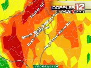
Montgomery Radar - WSFA
Tornado damage has been reported near Montgomery in the Pintlala community.

---

BULLETIN - EAS ACTIVATION REQUESTED TORNADO WARNING NATIONAL WEATHER SERVICE BIRMINGHAM AL 953 AM CST WED NOV 15 2006 THE NATIONAL WEATHER SERVICE IN BIRMINGHAM HAS ISSUED A * TORNADO WARNING FOR... MONTGOMERY COUNTY IN SOUTH CENTRAL ALABAMA THIS INCLUDES THE CITIES OF...MONTGOMERY...PINTLALA...PIKE ROAD * UNTIL 1045 AM CST *

AT 953 AM CST...NATIONAL WEATHER SERVICE DOPPLER RADAR INDICATED A SEVERE THUNDERSTORM CAPABLE OF PRODUCING A TORNADO 8 MILES SOUTHWEST OF PINTLALA...MOVING NORTHEAST AT 35 MPH. *

THE TORNADO IS WILL BE NEAR... PINTLALA BY 1000 AM CST 6 MILES NORTHWEST OF SPRAGUE BY 1005 AM CST SNOWDOUN BY 1010 AM CST 6 MILES SOUTHEAST OF MONTGOMERY BY 1020 AM CST PIKE ROAD BY 1030 AM CST


9:36 a.m. 33/40 Doppler

BULLETIN - EAS ACTIVATION REQUESTED TORNADO WARNING NATIONAL WEATHER SERVICE BIRMINGHAM AL 934 AM CST WED NOV 15 2006 THE NATIONAL WEATHER SERVICE IN BIRMINGHAM HAS ISSUED A * TORNADO WARNING FOR...

SOUTHEASTERN LOWNDES COUNTY IN SOUTH CENTRAL ALABAMA * UNTIL 1000 AM CST * AT 934 AM CST...NATIONAL WEATHER SERVICE DOPPLER RADAR INDICATED A SEVERE THUNDERSTORM CAPABLE OF PRODUCING A TORNADO NEAR FORT DEPOSIT...OR ABOUT 18 MILES SOUTHWEST OF PINTLALA...MOVING NORTHEAST AT 50 MPH. *

THE TORNADO IS WILL BE NEAR... INTERSTATE 65 IN LOWNDES COUNTY FORT DEPOSIT AT 940 AM CST


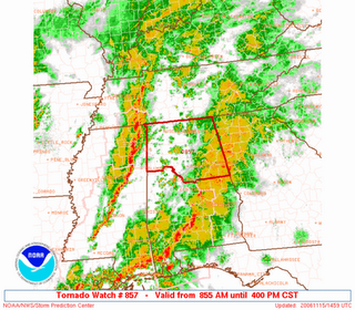
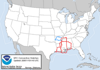
URGENT - IMMEDIATE BROADCAST REQUESTED TORNADO WATCH NUMBER 857 NWS STORM PREDICTION CENTER NORMAN OK 855 AM CST WED NOV 15 2006
THE NWS STORM PREDICTION CENTER HAS ISSUED A TORNADO WATCH FOR PORTIONS OF NORTHERN ALABAMA EFFECTIVE THIS WEDNESDAY MORNING AND AFTERNOON FROM 855 AM UNTIL 400 PM CST. TORNADOES...HAIL TO 1.5 INCHES IN DIAMETER...THUNDERSTORM WIND GUSTS TO 80 MPH...AND DANGEROUS LIGHTNING ARE POSSIBLE IN THESE AREAS.

THE TORNADO WATCH AREA IS APPROXIMATELY ALONG AND 75 STATUTE MILES EAST AND WEST OF A LINE FROM 35 MILES SOUTH SOUTHEAST OF BIRMINGHAM ALABAMA TO 25 MILES NORTH NORTHWEST OF HUNTSVILLE ALABAMA.
FOR A COMPLETE DEPICTION OF THE WATCH SEE THE ASSOCIATED WATCH OUTLINE UPDATE (WOUS64 KWNS WOU7). REMEMBER...A TORNADO WATCH MEANS CONDITIONS ARE FAVORABLE FOR TORNADOES AND SEVERE THUNDERSTORMS IN AND CLOSE TO THE WATCH AREA. PERSONS IN THESE AREAS SHOULD BE ON THE LOOKOUT FOR THREATENING WEATHER CONDITIONS AND LISTEN FOR LATER STATEMENTS AND POSSIBLE WARNINGS. OTHER WATCH INFORMATION...CONTINUE...WW 853...WW 854...WW 855...WW 856...

DISCUSSION...DEEP LOW OVER AR WITH INTENSE UPPER TROUGH ROTATING EWD ACROSS CENTRAL GULF STATES TODAY. N/S SQUALL LINE MOVING EWD ACROSS MS WITH A VERY FAVORABLE SHEAR PROFILE FOR SUPERCELLS/TORNADOS IN PLACE EWD ACROSS NRN AL. INSTABILITY IS LIMITED HOWEVER GIVEN THE STRONG SHEAR...SUPERCELLS ARE LIKELY TO BE EMBEDDED WITHIN THE SQUALL LINE AS IT MOVES EWD ACROSS WATCH WITH DAMAGING WINDS AND ISOLATED TORNADOES. AVIATION...TORNADOES AND A FEW SEVERE THUNDERSTORMS WITH HAIL SURFACE AND ALOFT TO 1.5 INCHES. EXTREME TURBULENCE AND SURFACE WIND GUSTS TO 70 KNOTS. A FEW CUMULONIMBI WITH MAXIMUM TOPS TO 500. MEAN STORM MOTION VECTOR 24040.

Today's Severe Weather

As mentioned last night there is a significant risk of severe weather including tornadoes across Alabama today. Damage has already been reported from tornadoes in south MS.

According to Alabamawx writer JB Elliott:

* 2:37 AM: Tornado near Sumrall, mainly the Rocky Branch Community. Several homes destroyed. A mobile home blown into a pond. Six persons were injured.

* 3:36 AM: Probable tornado 4 miles SE of Laurel, in Jones County. Several homes near Township Road with significant damage. At least one home reported destroyed.

There are going to be at least three separate bands of rain and storms with some isolated supercells ahead of the main bands.

Our greatest threat in Alabama will be during the afternoon.

Severe Weather Threat Today


Latest mesoscale graphic from SPC at 5:55 a.m.


PDS Tornado Watch in MS until 10 a.m.


Watches in effect at 6 a.m.


Day one outlook from SPC - early a.m..

Tuesday, November 14, 2006

Severe Weather Outlook

As mentioned here several days ago, Alabama will likely experience a severe weather outbreak tomorrow. All of the parameters seem to be lining up: the position of the low, vertical wind shear, directional wind shear, and a strong jet to provide lifting all seem to be lining up. Even the timing of the storm appears to be bad for Alabama (the worst is expected from the late morning hours through the afternoon). The only factor that seems a bit uncertain is the degree of low level moisture present. Dew points are expected to rise rapidly prior to frontal passage, but whether they recover in time to phase up with the other parameters is still an open question.

The SPC believes that it will be a bad day. They already included the whole state of Alabama in a slight to moderate risk in their "Day Two" outlook issued earlier today. All of the state south of I-20 is in the moderate risk area. It will be interesting to see what changes are made to the outlook when we get up in the morning. A PDS tornado watch has already been issued in parts of Louisiana and Arkansas this evening. Stay tuned and be alert.

17 Years Ago

Tomorrow afternoon is an anniversary many people in Huntsville and Madison County would rather forget. An F4 tornado tore through Airport Road in Huntsville, between Memorial Parkway and Jones Valley School. Many lives were lost and others were changed forever.

Wednesday, November 08, 2006

Upcoming Weather Concerns

There may be a slight chance of severe weather in the South on Friday or Saturday November 10 and 11. There might be a more significant threat on Tuesday and Wednesday November 14 and 15. Stay tuned.

Tuesday, November 07, 2006

Rainy

Rain so far in Vinemont, AL has been 1.22" as of 7:10 a.m.

Monday, November 06, 2006

Rainy Night In Bama


Here is the WAFF Dopple 48 radar as of 9:44 tonight. We've had .48" of rain this evening and it is still falling. It is 54 degrees outside. Wish it was 23 degrees colder!

Friday, November 03, 2006

Beach Photos


Here are a few photos taken last week at Orange Beach, AL. James Spann added these to the 33/40 Weather Blog.

Sunset 11/2/06


I took this photo last night. James Spann added it to the 33/40 Blog.

Cold Morn

28.0 was the low here in Vinemont. It was the coldest temp so far this season.
Newer Posts Older Posts Home