Thursday, August 31, 2006

Ioke Approaches Wake

Wednesday, August 30, 2006

Links About Wake Island

Wake Island Photos

Wake Island - Wikipedia

Current weather conditions - Wake Island Army Airfield Airport

Thoughts About "Global Warming"

I read an article tonight from the Montgomery Independent. Here are a few of my thoughts in response to the article.

I can't help it! I have to ask a couple of questions. If we cannot even come within thousands of miles of predicting the track of Ernesto about five days in advance, how can we be so egotistical to think that we can predict LONG TERM climate change?

Second, even if we leap to that very unlikely conclusion, how can we be so egotistical as human beings to think that we can control climate when we can't even change the weather on a small scale?

My point is that in order to believe that global warming is man made and that it is something that can be solved by human intervention, one would have to be ascribing God-like power and intelligence to human beings.

One more thing while I'm on a roll: Why do so many of the articles about GLOBAL warming focus on the LOCAL weather of the past few weeks?

"...the weather generally seems to be getting warmer right here in Montgomery. For instance, the temperature hit 96 degrees on August 3rd, 100 degrees on the 4th (a record for that date), 101 degrees on the 5th (also a record), 97 degrees on the 6th, 99 degrees on the 7th, 102 degrees on the 8th (another record) and 98 degrees on the 9th. In addition, our area is almost 13 inches short of normal rainfall so far this year. We have always had tough summers but it is hard to recall when plants, animals and people have ever been so stressed out with the heat and drought."

Super Typhoon Ioke

Super Typhoon Ioke, on last advisory: sustained winds 155 mph, gusts to 190 mph, 50-foot waves Forecast 12 hours ahead sustained 160 mph, gusts 195 mph.

Super Typhoon Ioke


Ioke Threatens Wake Island

Tuesday, August 29, 2006

Morgan County Storms


This afternoon strong storms moved over Decatur between 2:30 and 3:00. I took my afternoon break to watch these storms approach from the west. We had approximately 1/2" of rain in 30 minutes, 30+ mph winds, and some lightning. I took some photos of these storms which James Span posted on the ABC 33/40 Weather Blog.

Monday, August 28, 2006

Latest on TS Ernesto

What a difference a day makes! Ernesto weakened to a tropical storm yesterday and crossed the southern tip of Haiti. The forecase now has Ernesto moving ove SE Cuba, then into the Florida peninsula between Key West and Miami. And to think, just a few days ago the models were saying this storm would be headed toward Texas!

Sunday, August 27, 2006

Hurricane Ernesto


Ernesto has been upgraded to Hurricane status.


Forecast track has been shifted radically eastward toward Florida peninsula

Saturday, August 26, 2006

Latest Update from NHC


Ernesto remains a tropical storm but the shear that it has been fighting showed signs of weakening today. Organization of the storm has also improved as the day has progressed. Ernesto will likely become a hurricane sometime tomorrow as it passes near Jamaica.

Outer Bands of Ernesto Near Puerto Rico


Puerto Rico Radar

Afternoon Ernesto Update


At 2pm AST, Tropical Storm Ernesto had maximum sustained winds of 50 mph and the minimum central pressure was 997 mb.

Morning Look at Ernesto


Ernesto seems to be holding together well despite some shear. The pressure has actually dropped a little. The models seem to be really coming together to forecast strengthening and for this thing to enter the Gulf.

Here is a great update from Bill Murray at the ABC 33/40 Weather Blog

Friday, August 25, 2006

Ernesto Forecast, Friday 8/25/06

It's Official: Ernesto is Born

BULLETIN
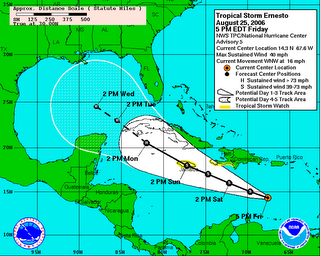
TROPICAL STORM ERNESTO ADVISORY NUMBER 5
NWS TPC/NATIONAL HURRICANE CENTER MIAMI FL AL052006
500 PM AST FRI AUG 25 2006

...HURRICANE HUNTER AIRCRAFT DETERMINES THAT TROPICAL DEPRESSION FIVE HAS BECOME TROPICAL STORM ERNESTO...

AT 5 PM AST...2100Z...THE GOVERNMENT OF HAITI HAS ISSUED A TROPICAL STORM WATCH FOR THE SOUTHWESTERN PENINSULA OF HAITI FROM THE HAITI-DOMINICAN REPUBLIC BORDER WESTWARD TO THE SOUTHWEST TIP OF HAITI. ALSO AT 5 PM AST...THE GOVERNMENT OF JAMAICA HAS ISSUED A TROPICAL STORM WATCH FOR JAMAICA.

INTERESTS IN THE CAYMAN ISLANDS AND WESTERN CUBA SHOULD MONITOR THE PROGRESS OF ERNESTO.

FOR STORM INFORMATION SPECIFIC TO YOUR AREA...INCLUDING POSSIBLE INLAND WATCHES AND WARNINGS...PLEASE MONITOR PRODUCTS ISSUED BY YOUR LOCAL WEATHER OFFICE.

AT 500 PM AST...2100Z...THE CENTER OF TROPICAL STORM ERNESTO WAS LOCATED NEAR LATITUDE 14.3 NORTH...LONGITUDE 67.6 WEST OR ABOUT 300 MILES...485 KM...SOUTH-SOUTHWEST OF SAN JUAN PUERTO RICO AND ABOUT 660 MILES...1065 KM...EAST-SOUTHEAST OF KINGSTON JAMAICA.

ERNESTO IS MOVING TOWARD THE WEST-NORTHWEST NEAR 16 MPH...26 KM/HR
...AND THIS GENERAL MOTION IS EXPECTED TO CONTINUE FOR THE NEXT 24 HOURS.

MAXIMUM SUSTAINED WINDS ARE NEAR 40 MPH...65 KM/HR...WITH HIGHER GUSTS. ADDITIONAL STRENGTHENING IS POSSIBLE DURING THE NEXT 24 HOURS.

TROPICAL STORM FORCE WINDS EXTEND OUTWARD UP TO 90 MILES...150 KM FROM THE CENTER.

THE LATEST MINIMUM CENTRAL PRESSURE REPORTED BY AN AIR FORCE RESERVE HURRICANE HUNTER AIRCRAFT IS 1004 MB...29.65 INCHES.

RAINFALL AMOUNTS OF 3 TO 6 INCHES ARE EXPECTED IN ASSOCIATION WITH ERNESTO ACROSS PORTIONS OF HISPANIOLA AND JAMAICA...WITH 1-3 INCHES EXPECTED FOR PARTS OF PUERTO RICO AND THE DUTCH NETHERLAND ANTILLES.

REPEATING THE 500 PM AST POSITION...14.3 N...67.6 W. MOVEMENT TOWARD...WEST-NORTHWEST NEAR 16 MPH. MAXIMUM SUSTAINED WINDS...40 MPH. MINIMUM CENTRAL PRESSURE...1004 MB.

AN INTERMEDIATE ADVISORY WILL BE ISSUED BY THE NATIONAL HURRICANE CENTER AT 800 PM AST FOLLOWED BY THE NEXT COMPLETE ADVISORY AT 1100
PM AST.

$$
FORECASTER BEVEN

TD 5 Update

What will probably soon be Tropical Storm Ernesto is now south of Puerto Rico. The National Hurricane Center predicts it will move in the general direction of Jamaica as a tropical storm between now and Sunday. It is predicted to become a hurricane after passing near Jamaica.

Thursday, August 24, 2006

Ernesto Forming?


This is the most significant thing going right now in the Atlantic Basin. There is a strong tropical wave over the windward islands. Right now a hurricane hunter aircraft is investigating this area. I fully expect this storm to become Tropical Storm Ernesto during the next 24 to
36 hours. Models eventually take this system into the Gulf, so we will be watching it very closely.

Tuesday, August 22, 2006

TD4 to become Debby?

It sure looks like we might have our third named storm of the year soon. There are some other areas that merit watching for development as well.

Monday, August 21, 2006

A Not-So-Happy Birthday

On this date one year ago, Hurricane Katrina was being conceived. It would become a tropical depression on August 23, a tropical storm on August 24, and a hurricane by August 25. Here is a look back from the WGN Weather Weblog.

Saturday, August 19, 2006

Slow Hurricane Season and Global Warming?

Here is a funny commentary about global warming and this season's slower than expected hurricane season:

Calm hurricane season bums out Weather Channel, by TIM ROWLAND

Tuesday, August 15, 2006

Tropical Development

This morning there are two areas to watch for possible tropical development. First there is a broad area of low pressure at the surface in the Atlantic Ocean north of the Bahamas. There is also a tropical wave near the Cape Verde Islands off the coas of Africa. Any develpoment is forecast to be slow according to the NHC.

Latest NHC Tropical Weather Outlook

GOES East Hurricane Secor Visible Image

Friday, August 11, 2006

Tropical Update

No significant tropical development is expected in the Atlantic Ocean, Carribbean Sea, or Gulf of Mexico in the next few days. Chris died before reaching hurricane status, then the tropical wave that had potential to become Debby also fizzled out. There is some convection about to come off the coast of Africa that should be watched in the next few days. However, conditions have been very unfavorable for development so far this season.

Thursday, August 10, 2006

Temporary Reprieve from the Heat?

By that title I am suggesting that we might see highs in the low 90's for a day or two instead of the low 100's, as we have over much of Alabama this week. It will still be hot, but a little more bearble. Tonight we had .32" of rain in a brief thunderstorm. We needed the rain badly. Maybe there is still hope for my watermelons.

Tuesday, August 08, 2006

Where are the Hurricanes?

Thus far the 2006 Atlantic Hurricane season has been quiet as a proverbial mouse. That is not to say that things won't change. August and September are always the peak months of tropical development. Nevertheless, it is safe to say that this year has already not lived up to last year and the pre-season "hype". Today NOAA revised it's seasonal forecast downward, a few days after Dr. Gray out in Colorado did the same.

Wind shear has hindered development in the Atlantic and the Caribbean. Water temperatures are not as warm as last year in parts of these regions either. I still expect significant storms to develop in the weeks to come.

Here's my little 'jab' at those who are sold on global warming as a cause for last year's spike in hurricane activity: Has the globe cooled this year?

Thursday, August 03, 2006

Update on Chris

Chris is weakening due to wind shear and his track may take him very close to Hispaniola and Cuba, which will make further development unlikely. If he can stay in tact, he still poses a threat to the Gulf.

Yesterday afternoon, James Spann postulated tht Chris would likely be steered west due to a high pressure ridge over the southern US.

Wednesday, August 02, 2006

Tropical Storm Chris

Updates on Tropical Storm Chris can be found at the National Hurricane Center page. Chris is a small storm geographically speaking. As of 4 a.m. Central Time, maximum sustained winds were at 60 mph. The current track from the National Hurricane Center predicts that Chris will become a hurricane by tomorrow afternoon. Looking into the future, by 1 a.m. Monday, The cone of uncertainty is pretty wide, extending from the tip of the Yucatan Peninsula to Cocoa Beach, Florida. However, the center of the cone places the hurricane over Key West by 1 a.m. on Monday. That might be the worst case scenario for residents along the Gulf Coast. Water temperatures in the Gulf are extremely warm and any tropical system that makes it to the Gulf has the potential to explode into a major hurricane. It is to soon to predict this, but the situation deserves very close attention this week.

Visible Satellite Image
Visible Sat Loop
Infrared Sat Image
Infrared Sat Loop
Water Temperatures Along the Gulf Coast

I will be posting updates here on the blog.

Tuesday, August 01, 2006

Looking for Cold Weather Somewhere?

Try South Africa.

Or even Antartica.
Newer Posts Older Posts Home