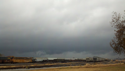
8:47 a.m., 11/16/11, Decatur, Alabama (Taken on my Droid phone)

8:50 a.m., 11/16/11, Decatur, Alabama
There were several reports of severe weather across Alabama today. Preliminary reports of possible tornadoes are coming in from Central and South Alabama. In North Alabama, reports so far have been confined to straight-line wind damage resulting from a severe thunderstorm in Madison County. The picture above was taken of the storm in Decatur that later caused the damage in Huntsville and Madison County.
The National Weather Service in Huntsville did a good job warning for the storm. At 8:42 a.m. a Severe Thunderstorm Warning was issued for portions of Morgan, Limestone and Madison counties. At 9:15 another Severe Thunderstorm Warning was issued for central portions of Madison County until 9:45.
Reports so far include the following:
8:27 am, 2 NE of Chalybeate: roof blown off porch, trees down, & awning blown off mobile home.
9:07 am, 4 miles north of Madison: trees and power lines down
9:15 am, Providence area: two reports of 55-65 mph wind gust reported
9:15 am, 911 Call Center in Huntsville: reported 74 mph wind gust
9:25 am, tree reported down on home and power lines down in N Huntsville.
Video as the storm approached Decatur and the first warning was being issued:

Radarscope capture by Chris Palmgren
Video of velocity loop on radar from Chris Palmgren:
Straight line winds knocked a tree on Pulaski Pike and power outages were reported on Shady Lane Drive. In Rutledge Heights, a tree was blown onto a car, and Johnson High School's marquee was blown off the frame.
Phoros from WHNT 19
...


