Thursday, May 31, 2007

Things are looking up for a chase...

One of my teammates at the Southern Weather Brigade, Dewdrop, has won a cool trip to do some storm chasing with the Twister Sisters beginning next week. I am so happy for her. If you are interested in severe weather at all, watch her blog closely during the next two weeks.

There is a dilemma with storm chasing. I am fascinated with storms and there is a side of me that really wants to see the action. I would love to see a wedge tornado on the plains! On the other hand, I have hoped many times for storms not to happen because there is so much potential for death, injury, and destruction for those in the path of a tornado.

The bottom line, though, is that all of my wishing and hoping will not make any difference in the weather. It is going to happen. When it does, I want to see it and learn about it. Storm spotting is a valuable tool in both the warning process itself along with the data that contibutes to our overall understanding and ability to predict dangerous weather.

Back to Dewdrop's upcoming chase. Things are looking good. When she first mentioned the dates, I wondered how things would look. Things are now looking up!

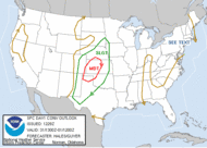
As of this morning the SPC outlooks are as follows:

Thursday May 31 - MODERATE RISK in western KS and western OK

Friday June 1 - SLIGHT RISK between TEXAS and IOWA


Saturday June 2 - SLIGHT RISK - TEXAS


Sunday and Monday, June 3 and 4 - TEXAS
Wednesday June 5 - OK, KS, NE, and SD

Wednesday, May 30, 2007

Another smoky day in paradise...

This is unreal. You can walk outdoors in North Alabama this morning and see a blue haze and smell wood burning. This is second hand smoke from South Georgia; over 300 miles southeast of here! It is rather amazing, even to a weather geek like me, how air can be transported over such a great distance and remain "in tact". We have an amazingly fluid atmosphere and numerical computer models will never completely replace the human side or "art" to forecasting.

Smoke, Smoke, Smoke That Cigarette by JBE

Bad Air Quality Again by Stephanie Frost

Smoke, drought and more... by Dewdrop

Tuesday, May 29, 2007

The much-anticipated post

For my small band of loyal readers, I have finally found a spare second to post something. I have been pouring my heart and soul into my son's baseball team. When I haven't been doing that I have been busy at work and doing stuff with my kids. I have also been planning a special vacation for my boys and I. So far I have reservations for three nights in the big "D" (Dallas, TX) and tickets to three Rangers games. My oldest son is a huge Sammy Sosa fan and has been since he was five. He was hoping that Sammy could make it back to the majors. I am hoping and praying that somehow he can meet Sammy and get his autograph. I purchased an autographed photo for him one time, but he really wants to meet him. So I have been scheming!

The weather here has been highlighted by second hand smoke, sent over from my friends in South Georgia and Florida.

Haze from wildfires expected to return today
By Nancy Glasscock
The Cullman Times
Widespread haze from wildfires in southeastern Georgia and northeastern Florida was expected to return to Cullman County again today, according to the National Weather Service Forecast Office in Huntsville. During the past few weeks, a blanket of haze periodically covered north Alabama and southern Middle Tennessee. The most significant contributors to the smoke have been wildfires called “big Turnaround” and “Bugaboo” which have burned more than 430,000 acres in Ware and Charlton counties in Georgia and Baker County, Fla., respectively. The NWS reported the first bout of smoke moving across north Alabama May 14 and 15, with reduced visibilities as low as three miles on May 15.

Wednesday, May 23, 2007

This just in from the Alabama EMA...

As you already know, this week has been designated as Hurricane Awareness Week and many activities are going on around the country to prompt people to prepare for the upcoming hurricane season that starts next Thursday, June 1st.

The NOAA and the National Hurricane Center released their forecast yesterday and they have the following:


For the full story, please follow this link to the National Hurricane Center's Story: http://www.noaanews.noaa.gov/stories2007/s2864.htm

This being said, Mobile Weather National Service Office and Alabama EMA have once again partnered to produce the 2007 Hurricane Awareness Booklet. It has been published and is being distributed in Schools in Mobile and Baldwin Counties along with booklets to the EMA Offices in Alabama's southernmost counties. You may download a copy of this booklet at the following web site: http://www.srh.noaa.gov/mob/

Many preparedness tools are available online to aid you in your preparations. The following links are a few of the web resources available:

The Federal Emergency Management Agency's (FEMA) preparedness resources: http://www.fema.gov/hazard/hurricane/hu_season.shtm

A free online hurricane planning tool, follow this link: http://www.onestorm.org

The "Hurricane Strike" education program which is a hurricane preparedness learning tool for the family geared toward children and endorsed by FEMA, NOAA, The Weather Channel and the American Red Cross, may be found at the follow link: https://www.meted.ucar.edu/loginForm.php?urlPath=hurrican

Please pass this information to all those in your offices and agencies and prompt them to make plans and preparations for the 2007 Hurricane Season.

Seeing how the other half lives

I'm not in a position to upload pictures of the smoke this morning, but we here in Alabama are getting a small taste of the misery residents of South Georgia have been encountering over the past month or so. Southeasterly winds have imported Georgia smoke into Alabama. One of my friends in Birmingham told me they thought that a fire was near them. I explained that the smoke from Georgia is coming this way, causing the haze. I thought they doubted me so I told how it can be seen satellite.

The smoke in my little corner of the state isn't that bad. It just creates an extra hazy sky and reduces visibility a little. It is nothing like what our friends in Georgia are going through. Our hears go out to them!

Here are a few interesting links:
My friends in South GA, Dewdrop and Rick
Rick submitted an excellent post on our team blog.
Air Quality Alert posted by JB Elliott
A Useful Tool posted by Jason Simpson
Smoke and Haze posted by Jason Simpson

---

11:45 update: It stinks outside. The smoke is getting worse.

Sunday, May 20, 2007

Last of the 40's?

The low here this morning was 46.0. That's very unusual for May 20 in North Alabama, but I'm loving it! I'm saving money on my power bill and enjoying the comfortable temps with low humidity. The visibility has been awesome the last few days and the sky is unusually blue for this time of the year. It sure beats the typical 80 degree plus temperatures with high humidity and haze. I think this will be our last 40 something morning, however until October.

Saturday, May 19, 2007

Fire Watch issued by NWS Huntsville

NWS issues fire watch for northern Alabama Florence Times Daily
North Alabama is under a fire watch today because low humidity and high winds are creating prime conditions for wildfires.The National Weather Service issued the watch to discourage residents from burning anything outdoors."People should not even burn unless they have to. Even then, we suggest they don't burn," said Kurt Weber a meteorologist at the Weather Service's Huntsville office.


Drought leads state forester to place Alabama under fire alert Florence Times Daily
As a drought continues to tighten its grip on Alabama, the state forester has placed all 67 counties under a fire alert.During the alert, which began Friday, the Alabama Forestry Commission will restrict the number of permits it issues for outdoor burning.


HYDROLOGIC OUTLOOK...UPDATED FOR FIRE WEATHER NATIONAL WEATHER SERVICE HUNTSVILLE AL 222 PM CDT SAT MAY 19 2007
...EXTREME DROUGHT PERSISTS......LIGHT MID WEEK RAINFALL NOT ENOUGH TO PUT A DENT IN RAINFALLDEFICITS......SYNOPSIS...ACCORDING TO THE U.S. DROUGHT MONITOR...THE ENTIRE CENTRAL TENNESSEE VALLEY IS IN THE EXTREME DROUGHT CATEGORY. THIS IS THE SECOND WORSTOF THE FIVE-LEVEL CLASSIFICATION SYSTEM USED BY THE U.S. DROUGHTMONITOR...AND INDICATIVE OF AT LEAST A ONCE-IN-TWENTY YEAR DROUGHT....
(see link for more)

Global warming isn't here this morning!

41.5 was the low this morning in my little corner of North Alabama.

Thursday, May 17, 2007

James Spann's Road Trip!

This is James' annual post about the best way to the Bama beaches. This is a great read!

Low

47.7 was the morning low here in my little corner of North Alabama this morning! Not bad for May 17!

Wednesday, May 16, 2007

Amazing photos from Greensburg, KS

These photos are by Mike Theiss at Ultimatechase.com.

If you ever wondered what EF-5 damaged looks like, here is a textbook example. This guy took some very high quality photos.

April 3, 1974 Superoutbreak of Tornadoes


Check out this video by James Spann. He interviews retired NWS employee J.B. Elliott, who is definitely a weather legend here in Alabama. J.B. describes what it was like to work that terrible Wednesday night 33 years ago.

I wrote my thoughts and linked other in a prior post.

Finally, a nice steady rain...


...but it probably won't amount to much; maybe one quarter to one half of an inch. Still, I am thankful. The drought continues however. Maybe this will help get rid of some of the GA/FL smoke that blew into Central Alabama yesterday. This was the WAFF 48 radar at 5:58 a.m.

Monday, May 14, 2007

NOAA Weather Radio...on the web

Here is a cool site that links you to streaming audio of numerous NOAA Weather radio transmitters across the nation.

Here is one for some of the wildest weather in the country.

I want to be here!

Foggy morn


I saw this fog on Lacon Mountain on I-65 near mile marker 317 Friday morning at 6:45. That is a beautiful place to drive in the morning. We had some storms the night before.

Thursday, May 10, 2007

Thorms...


WAFF 48 Radar at 6:58 p.m.

We had a strong storm tonight with gusty winds, frequent cloud to ground lightning, and very heavy rain. Check out the video taken around 7 p.m.

Off by 9,990

I try to stay non-political as much as possible here because this is a weather blog. Sometimes I can't keep quiet though. First, let me say that it was horrible of the Governor of Kansas to use the tragedy in her own state to make a political statement about the war. It was even more horrible to learn that her assertions didn't have any merit, according to the General in charge of the search and rescue operation. Between Friday night and Monday afternoon, he indicated that his team had searched all affected areas twice. That is roughly 44 square miles of damage that was checked twice in less than two days. He said he had all the equipment he needed. He did say that he would have had to ask for help from other states if another tornado of equal magnitude had hit at the same time. Then Obama tried to get into it and embarrassed himself in the process. I saw CNN's story on this Monday night and the headlines were very misleading. I guess that's just representative of the sad state of politics and journalism in 2007. That's a shame.

Obama overstates Kansas tornado deaths
RICHMOND, Va. - Barack Obama caught up in the fervor of a campaign speech Tuesday, drastically overstated the Kansas tornadoes death toll, saying 10,000 died. The death toll was 12. "In case you missed it, this week, there was a tragedy in Kansas. Ten thousand people died — an entire town destroyed," the Democratic presidential candidate said in a speech to 500 people packed into a sweltering Richmond art studio for a fundraiser. Obama mentioned the disaster in Greensburg, Kan., in saying he had been told by the office of Kansas Gov. Kathleen Sebelius that the state's National Guard had been depleted by its commitment to the Iraq War.


White House rebuts Guard shortage claim
WASHINGTON - The Bush administration and Kansas' governor started Tuesday pointing fingers at each other over the response to last week's devastating tornado. By lunchtime, both sides had backed down.

Monday, May 07, 2007

Storm Highway by Dan Robinson

I found some amazing video of the Greensburg, KS wedge tornado on this very cool site. Dan also has a chase blog within his site here. Take a look at this amazing video of the Greensburg tornado here. Here is the article about his chase on the Greensburg storm.

My favorite weatherman as a child...

...is still at it at age 73! I recently found John Coleman doing the weather for KUSI in San Diego, CA. Watch this video and I am sure you will see why a child would have liked him! He makes it fun!

Meteorologist Mike Umscheid

Follow this link to a very cool story about how a meteorologist warned Greensburg, KS residents 20 minutes before an EF5 tornado destroyed 95 per cent of the town. There is no doubt that his work helped save many, many lives! Check out the video if you can.

Dodge City, KS Storm Report

Preliminary Storm Reports

Greensburg Tornado Rated EF-5 The First "5" Rating on the new Enhanced Fujita Scale and the first "5" classification since May 3, 1999 when an F5 tornado ripped through Moore, OK.

Tornado warning process worked in Greensburg, KS

Here is a link to an amazing post by Mike Umscheid, NWS employee and storm chaser in Dodge City, Kansas. He was operating the radar and issuing warnings for the NWS Dodge City Friday night. He has a really interesting blog, High Plains Drifter.

Here is an excerpt from the post:
the "…tornado emergency for Greensburg…" in my next SVS… it was like instinct - just did it. Those few minutes after watching one of the most incredible velocity couplets go directly over one of your good sized communities in your CWA… I was just too anxious. Then the message was sent out… a plea from Greensburg dispatch… "Ford County communications this is Greensburg… we just took a direct hit…".. that came no more than about 3 or 4 minutes after the couplet passed over. I then immediately sent out another SVS indicating that Greensburg likely took a direct hit.

Saturday, May 05, 2007

Photos from Greensburg, KS

Check out these photos. Simply amazing.

Storms looking bad in KS again

!


This is NOT good! God bless these people!

BULLETIN - EAS ACTIVATION REQUESTED
TORNADO WARNING
NATIONAL WEATHER SERVICE DODGE CITY KS
837 PM CDT SAT MAY 5 2007

THE NATIONAL WEATHER SERVICE IN DODGE CITY HAS ISSUED A

* TORNADO WARNING FOR…
NORTHERN KIOWA COUNTY IN SOUTH CENTRAL KANSAS.

* UNTIL 900 PM CDT

* AT 833 PM CDT…NATIONAL WEATHER SERVICE DOPPLER RADAR INDICATED AND
A STORM CHASER REPORTED A TORNADO 1 MILES WEST OF GREENSBURG…MOVING
NORTH AT 25 MPH.

* LOCATIONS IMPACTED INCLUDE…
GREENSBURG…
HAVILAND…
RURAL RESIDENCES OF NORTHERN KIOWA COUNTY.

THIS INCLUDES HIGHWAY 54 BETWEEN MILE MARKERS 101 AND 124.

WHEN A TORNADO WARNING IS ISSUED BASED ON DOPPLER RADAR…IT MEANS
THAT STRONG ROTATION HAS BEEN DETECTED IN THE STORM. A TORNADO MAY
ALREADY BE ON THE GROUND…OR IS EXPECTED TO DEVELOP SHORTLY. IF YOU
ARE IN THE PATH OF THIS DANGEROUS STORM…MOVE INDOORS AND TO THE
LOWEST LEVEL OF THE BUILDING. STAY AWAY FROM WINDOWS. IF DRIVING…DO
NOT SEEK SHELTER UNDER A HIGHWAY OVERPASS.

A TORNADO WATCH REMAINS IN EFFECT UNTIL 1000 PM CDT SATURDAY EVENING
FOR WEST CENTRAL KANSAS. A TORNADO WATCH ALSO REMAINS IN EFFECT UNTIL
1000 PM CDT SATURDAY EVENING FOR SOUTHWESTERN KANSAS.

Tornado tragedy in Kansas

Last night a killer tornado destroyed the 95 per cent of the town of Greensburg, Kansas. As of 4 p.m. CDT, the death count is up top 9 and sadly, it is likely to rise.

9 Die as Tornado Levels Kansas Town from Associated Press
Most of this southwest Kansas town was destroyed by a tornado, part of a violent storm system blamed for at least nine deaths, officials said Saturday amid warnings of more severe weather. It may take days for emergency crews to remove all the victims _ dead and alive _ from the rubble of homes and businesses, the city administrator said Saturday.

Tornado Destroys Much of Kansas Town by VOA News
An emergency official in the Midwestern U.S. state of Kansas says the tornado that devastated a small town Friday night is the most significant emergency the state has dealt with in a long time. At least seven people died and dozens were injured when a massive twister raked across the town of Greensburg, which has about 1,600 residents. Witnesses said that 75 percent to 90 percent of the town was destroyed.

Happy Birthday Weather Channel

On May 2, 1982 The Weather Channel signed on for the first time. In the beginning TWC had 4.2 million cable subscribers. TWC was the brainchild of Chicago-based ABC meteorologist John Coleman. Now nearly 87 million U.S. cable subscribers can view TWC.

I remember the beginning of TWC well. I was one of the fortunate wx geeks who had cable back then. I liked TWC back in the 80’s and early 90’s much more than the format they have now. I remember John Coleman from Chicago’s WLS Channel 7 when I lived in Ottawa, Illinois for a few years as a young boy (preschool-1st grade). Coleman was crazy, but as a kid, I loved him. I’ll never forget when I saw him use a snake as a pointer for his wx map! Watching him helped birth my lifetime fascination with the wx.

I want to see a true 24 hour weather channel (for weather purists) that is totally weather (minus politics and with less documentaries during times of severe weather)!

Tuesday, May 01, 2007

Let's cut back on that toilet paper!

Only in 2007 could such an idiotic concept be mentioned seriously in the public discourse. My children got a kick out of it, though!

Crow calls for limit on loo paper


Amazing video of Enterprise, AL tornado 3/1/07

Newer Posts Older Posts Home