I took my lunch break today to put together a few maps outlining the possibility of strong to severe weather in the South on Sunday March 2 through Tuesday March 4, 2008. This model data is from today's 12Z run of the GFS.
Wednesday, February 27, 2008
Severe weather early next week?
Models are pointing to a major severe weather outbreak, yet again, early next week. This possible event is 5-6 days away, so there is much more time ahead to prepare.
Another flizzard today in North Alabama
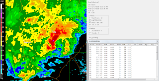
11:30 ARMOR radar from UAH
12:30 ARMOR radar from UAH
A few pictures of today's flizzard...
Tuesday, February 26, 2008
Snow is falling...
...and it began to accumulate lightly between 9:30 and 10.
Plus, "Baby it's cold outside!" The temp is down to 32 and it feels much colder in the wind...
---
SPECIAL WEATHER STATEMENT NATIONAL WEATHER SERVICE HUNTSVILLE AL 1020 PM CST TUE FEB 26 2008
ALZ006-008>010-TNZ076-096-097-271100- MADISON-MARSHALL-JACKSON-DE KALB-MOORE-LINCOLN-FRANKLIN TN- INCLUDING THE CITIES OF...HUNTSVILLE...GUNTERSVILLE... SCOTTSBORO...FORT PAYNE...LYNCHBURG...FAYETTEVILLE...WINCHESTER 1020 PM CST TUE FEB 26 2008
...LIGHT SNOW POSSIBLE OVERNIGHT ACROSS SOUTHERN MIDDLE TENNESSEE AND PORTIONS OF NORTHEASTERN ALABAMA...
A STRONG LOW PRESSURE SYSTEM LOCATED IN THE NEW ENGLAND STATES WILL CONTINUE TO PULL COLD AIR ACROSS THE TENNESSEE VALLEY. AT THE SAME TIME...AN UPPER LEVEL DISTURBANCE WILL COMBINE WITH THE COLD AIR AND RESIDUAL LOW LEVEL MOISTURE TO PRODUCE THE POTENTIAL FOR SNOW SHOWERS THROUGH THE EARLY MORNING HOURS. MOST AREAS WILL SEE SNOW AMOUNTS LESS THAN 1 INCH...MAINLY ON GRASSY AREAS ALONG WITH BRIDGES AND OVERPASSES.
IN THE HIGHER ELEVATIONS OF SOUTHERN MIDDLE TENNESSEE AND NORTHEASTERN ALABAMA...THE POTENTIAL FOR AROUND 1 INCH OF SNOWFALL IS POSSIBLE ON BOTH GRASSY AREAS AND ROADWAYS. LOCATIONS SUCH AS SEWANEE...MENTONE...MONTE SANO...AND HYTOP WILL BE THE MOST PRONE TO SEEING HIGHER SNOW ACCUMULATIONS.
MOTORISTS ARE URGED TO USE CAUTION OVERNIGHT AS SOME SLICK SPOTS DEVELOP...MAINLY ON BRIDES AND OVERPASSES AND IN HIGHER ELEVATION AREAS.
---
HAZARDOUS WEATHER OUTLOOK NATIONAL WEATHER SERVICE HUNTSVILLE AL 1039 PM CST TUE FEB 26 2008
THIS HAZARDOUS WEATHER OUTLOOK IS FOR NORTH ALABAMA AND PORTIONS OF SOUTHERN MIDDLE TENNESSEE.
.DAY ONE...OVERNIGHT...
LIGHT SNOW WILL CONTINUE TO FALL ACROSS THE TENNESSEE VALLEY FOR THE REST OF THIS EVENING. THE BEST CHANCE OF SNOW ACCUMULATIONS WILL BE OVER THE HIGHER TERRAIN OF SOUTHERN MIDDLE TENNESSEE...WHERE ONE TO TWO INCHES OF SNOW WILL BE POSSIBLE. FOR LOCATIONS EAST OF INTERSTATE 65...AROUND ONE HALF OF AN INCH OF SNOW WILL BE POSSIBLE ALSO OVER HIGHER TERRAIN LOCATIONS. WEST OF INTERSTATE 65 ONLY FLURRIES ARE EXPECTED.
EXPECT THE SNOW TO BEGIN TO TAPER OFF AFTER MIDNIGHT. TEMPERATURES WILL FALL INTO THE 20S OVERNIGHT...WHICH COMBINED WITH THE SNOW WILL CREATE SLICK SPOTS ON AREA ROADS...ESPECIALLY BRIDGES AND OVERPASSES.
My friend and co-CWG (cool weather geek), Dewdrop, had a very good opportunity today to witness a wall cloud and a funnel cloud in her neck of the woods. I won't retell the whole cool story here, but I will post some links.
There has been this long running hypothesis, referred to by Dew as the "Dewvoid". The "Dewvoid" was mysterious invisible hindrance to the existence of severe weather in any are that she happens to be located. Today, finally, this theory has been laid to rest!
Read, look, and listen to how the Dewvoid came to a glorious end today in South Georgia...
Storm Chasing Dew Style in South Georgia... the Dewvoid is Dead
On the road with Dewdrop
Thomasville, GA tornado
Lowndes County, GA tornadoes
---
News from WALB, including video
Clyattville - Many people in southern Lowndes County are still without power because of the storms. The southern part of the county took the biggest hit with uprooted trees and downed power lines. People in Clyattville think a tornado hit their town.Mollie Danner was home sick when she heard the tornado. "It was sort of a roar, but it was just so many twisting and screeching and I think it was pine limbs twisting."
Monday, February 25, 2008
Storms, then cold...
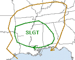
Slight risk issued by the Storm Prediction Center
I do not want to overstate this, but there is a slight risk for severe weather overnight in Alabama. Fortunately this system is not as potent as the one that went through here on February 6 or February 17. Nevertheless, there is a risk for damaging winds. The time of greatest risk will be during rush hour in the early morning hours. Storms may enter West Alabama around 3 a.m. and exit Alabama to the east by noon. Here is an excerpt from the SPC outlook:
DESPITE THE LOSS OF DAYTIME HEATING ...LOW-LEVEL MOISTENING AND
FORCING ASSOCIATED WITH THE SURFACE FRONT SHOULD BE SUFFICIENT TO
MAINTAIN THUNDERSTORMS OVERNIGHT.  THE SEVERE THREAT IS EXPECTED TO
EVOLVE TO A MORE DAMAGING WIND THREAT OVERNIGHT ACROSS PORTIONS OF
TN/MS/AL...AS A LINEAR CONVECTIVE SYSTEM EVOLVES ALONG THE COLD
FRONT.
The big story this week will probably be the bitter cold weather on Wednesday. The models have been showing a major shot of cold air in here for Wednesday for at least a week. I would not be surprised if the temperature does not make it out of the 30's in parts of North Alabama on Wednesday. Bundle up and stay warm!
Before I go, let me give you a "head's up" for another possible severe weather outbreak next Tuesday March 4. A lot can change between now and then, but this one certainly bears watching.
Lawrence County tornado photos
Created with Admarket's flickrSLiDR.
My friend Mike owns property in Southern Lawrence County near where the February 6, 2008 tornado path began. It took out quite a few of the trees on his land. In the second photo, Mike points to the area the tornado touched down. These photos were taken by his daughter Rachel.
At this time one week ago, a storm system was getting it's act together that would turn into a tornado outbreak over South and East Alabama, Northwest Florida, and West Georgia. A mesocyclone was in its infancy southwest of Fort Morgan, AL. This storm would eventually travel 320 miles and eight hours from the coast of Alabama at Fort Morgan in Baldwin County all the way to the northeast of Macon, GA. Property damage was extensive and there were numerous injuries. Amazingly and thankfully there were no fatalities.
This morning I received the following comment from a viewer of my YouTube page in response to a video that I posted about the Prattville tornado.
"From my yard I can see 7 destroyed homes.The PPD still has a presence at every entrance of the neighborhood and are doing regular patrols.The Red Cross ERT(thanks to chick- fil-A and some little deli I didn't remember the name) has made sure we have food,cleaning supplies, ect.State Troopers blocked the roads so no one could get in.Two minutes after, neighbors were searching the reckage for survivors,the PFD,Alagasco,AL power,I feel that everyone pulled together as best as can be expected. Thanks"
Here is a look back at chatter from the ABC 33/40 Skywatcher chat. The first section covers the supercell as it approached the Alabama Coast in Baldwin County and later produced a tornado in Molino, FL. The second part is a discussion during the time tornadoes were happening in Lowndes, Montgomery, Chilton, Randolph, and other counties later in the afternoon.
"(10:01:00) Mike Wilhelm Vinemont Cullman-Laptop: what are the conditions in Baldwin? (10:01:17) wlpowell63: Stand By.. (10:02:39) wlpowell63: Foley reporting... Temp 70.8 DP 63.6 Hum 78% Wind SE@5 Baro 29.80. (10:02:55) Mike Wilhelm Vinemont Cullman-Laptop: really moist there (10:04:07) Mike Wilhelm Vinemont Cullman-Laptop: strong storm headed for Foley on Radar (10:04:54) MBwheeler8 - Auburn: Temp is currently 63degrees. Dewpoint 57 winds out of SSE 10mph no rain yet (10:05:01) ashleyb3340: Not the same spot...but the skycam in Gulf Shores has 66/64...and man is the Gulf stirred up (10:06:28) Mike Wilhelm Vinemont Cullman-Laptop: storm approaching Foley / Gulf Shores (10:07:42) Mike Wilhelm Vinemont Cullman-Laptop: Wl powell...can you let us know what happens when that storm passes (10:07:58) wlpowell63: Will do. (10:09:03) Mike Wilhelm Vinemont Cullman-Laptop: looks like a broad area of rotation (10:09:57) Mike Wilhelm Vinemont Cullman-Laptop: it will be interesting to watch this on the GS skycam (10:10:51) wlpowell63: Roger that. I am hearing thunder as I type. (10:12:42) wlpowell63: Its going to pass the Cabana Beach Club. (10:13:04) wlpowell63: Its about 10 miles west of GS. (10:14:06) Mike Wilhelm Vinemont Cullman-Laptop: skycam looks very overcast, but darker to SW (10:14:25) wlpowell63: Thats it. (10:18:50) wlpowell63: Correction, its going to be on top of Fort Morgan. (10:19:09) Mike Wilhelm Vinemont Cullman-Laptop: That's what I thought (10:19:34) wlpowell63: I have a Z9 that looks like it will go into Fort Morgan. (10:23:15) wlpowell63: Fort Morgan, Bon Secour, Weeks Bay, Magnolia Springs, West Foley, Summerdale. (10:24:01) Mike Wilhelm Vinemont Cullman-Laptop: no warnings for Baldwin? I wonder if you have a sig wx alert? (10:24:23) Mike Wilhelm Vinemont Cullman-Laptop: tornado warning in SE MS (10:24:24) wlpowell63: I do, but no alerts yet. (10:24:58) Mike Wilhelm Vinemont Cullman-Laptop: tor warn (10:31:57) wlpowell63: I see. But no alerts yet. (10:32:29) wlpowell63: I see the radar, but no alerts yet. (10:37:38) ashleyb3340: now we've got a spot of sun on the beach (10:38:13) KI4PSG; Caleb in Cragford: The beach looks rough this morning (10:38:16) wlpowell63: Ok, we got an alert. (10:38:39) Mike Wilhelm Vinemont Cullman-Laptop: it's knocking on your door wlpowell (10:39:21) wlpowell63: Yep. (10:39:24) Mike Wilhelm Vinemont Cullman-Laptop: tornado warning (10:39:31) wlpowell63: Stand By. (10:39:50) Mike Wilhelm Vinemont Cullman-Laptop: BULLETIN - EAS ACTIVATION REQUESTED TORNADO WARNING NATIONAL WEATHER SERVICE MOBILE AL 1037 AM CST SUN FEB 17 2008 THE NATIONAL WEATHER SERVICE IN MOBILE HAS ISSUED A * TORNADO WARNING FOR... SOUTHWESTERN BALDWIN COUNTY IN SOUTHWEST ALABAMA... * UNTIL 1115 AM CST * AT 1035 AM CST...NATIONAL WEATHER SERVICE DOPPLER RADAR INDICATED A SEVERE THUNDERSTORM CAPABLE OF PRODUCING A TORNADO NEAR FORT MORGAN...OR ABOUT 6 MILES SOUTHEAST OF DAUPHIN ISLAND...MOVING NORTHEAST AT 30 MPH. * THE TORNADO WILL BE NEAR... 8 MILES NORTHWEST OF PALMETTO BEACH AND 8 MILES NORTHWEST OF GASQUE BY 1055 AM CST... TURKEY BRANCH...MOUTH OF WEEKS BAY AND POINT CLEAR BY 1110 AM CST... MARLOW...MAGNOLIA SPRINGS...HOUSTONVILLE AND 6 MILES SOUTHEAST OF BATTLES WHARF BY 1115 AM CST... (10:40:01) wlpowell63: They just spotted a funnel Cloud near Fort Morgan. (10:40:12) sharcrop46 (Coker): Southern Tuscaloosa Co and northern Greene Co sounds like they are getting hammered! (10:40:31) wlpowell63: Sheriffs Department has reported a funnel cloud near Fort Morgan. (10:40:39) JB Elliott, Trussville is now known as JB Elliott in Trussville (10:40:40) JB Elliott in Trussville is now known as JB Elliott, Trussville (10:40:40) JB Elliott, Trussville is now known as JB Elliott in Trussville (10:40:47) lanekilgore Muscadine,AL: Dp climbing here but still only 52. Temp is 57. (10:41:13) Mike Wilhelm Vinemont Cullman-Laptop: circulation has tigtened on radar as I have been watching it near Ft Morgan... (10:41:27) Mike Wilhelm Vinemont Cullman-Laptop: not tight as a tick's butt yet, though (10:41:28) wlpowell63: Roger that. (10:41:34) Mike Wilhelm Vinemont Cullman-Laptop: as James would say... (10:43:07) Mike Wilhelm Vinemont Cullman-Laptop: here is one site for radar (10:43:17) KI4PSG; Caleb in Cragford: Thanks (10:43:20) wlpowell63: Possible Tornado on Fort Morgan Road headed to Bon Secour. (10:44:08) Mike Wilhelm Vinemont Cullman-Laptop: the left margin allows you to change views (10:44:32) KI4PSG; Caleb in Cragford: Thanks! This helps (10:45:53) wlpowell63: Tornado on the ground at Fort Morgan headed notheast. (10:50:03) wlpowell63: Got thunder here in Foley. (10:52:13) wlpowell63: 14.5MPH here SSW. (10:53:17) wlpowell63: The Y0 is now at Weeks Bay. (10:53:51) Mike Wilhelm Vinemont Cullman-Laptop: I see that...it may be leaving Weeks Bay as we speak (10:54:09) wlpowell63: Roger that. (10:55:14) Mike Wilhelm Vinemont Cullman-Laptop: Be careful wlpowell...it will be on you soon! (10:56:08) wlpowell63: We will. (10:57:03) wlpowell63: We are east of Foley so it will look like it will nick us. (10:57:38) wlpowell63: No report from LE as of yet. (10:57:52) wlpowell63: I got my scanner on. (10:58:20) wlpowell63: Law Enforcement. (10:59:16) sharcrop46 (Coker) left the room. (10:59:53) wlpowell63: That tail end of that storm is at Weeks Bay. (11:02:14) wlpowell63: At 1054 AM CST... Doppler Weather Radar Indicated A Possible Tornado About 8 Miles Southwest Of Mouth Of Weeks Bay... Moving Northeast At 15 To 20 Mph. The Tornado Will Be Near... Mouth Of Weeks Bay... Turkey Branch... 6 Miles Southwest Of Magnolia Springs And 9 Miles Southwest Of Marlow By 1115 AM CST... (11:05:53) Mike Wilhelm Vinemont Cullman-Laptop: circulation looks wo be west of Foley, maybe wnw (11:06:06) wlpowell63: Roger that. (11:07:54) wlpowell63: Looks like it is going to Summerdale in a little bit. (11:11:59) wlpowell63: It is passing south of Robertsdale. No reports of any tornado. (11:13:13) wlpowell63: Its an extension. (11:14:30) wlpowell63: AT 1108 AM CST...NATIONAL WEATHER SERVICE DOPPLER RADAR INDICATED A SEVERE THUNDERSTORM CAPABLE OF PRODUCING A TORNADO NEAR MARLOW MOVING NORTHEAST AROUND 40 MPH. THE CENTER OF CIRCULATION APPEARS TO BE RE-DEVELOPING. * THE TORNADO WILL BE NEAR... ROBERTSDALE BY 1120 AM CST... ELSANOR AND ROSINTON BY 1125 AM CST... GATESWOOD BY 1135 AM CST... BARRINEAU PARK BY 1140 AM CST... (11:20:08) wlpowell63: Heavy rain in Weeks Bay reported by ham radio operator. (11:22:40) wlpowell63: Ham radio reported a funnel cloud south of Robertsdale. (11:24:33) wlpowell63: New warning. (11:24:55) wlpowell63: Circulation near Summerdale. (11:26:00) Mike Wilhelm Vinemont Cullman-Laptop: rotation does look more impressive again in Baldwin (11:28:00) wlpowell63: TV station in Mobile said there was some strong rotation NE of Summerdale. (11:28:51) wlpowell63: But no reports of any TDs. (11:30:08) wlpowell63: James, Had one TD near Fort Morgan was reported by Law Enforcement agency. No Damages so far. (11:30:52) Mike Wilhelm Vinemont Cullman-Laptop: tornado report from Ft Morgan? who made the rept? not surprised (11:31:10) wlpowell63: Sheriff's department. (11:32:16) wlpowell63: ...A TORNADO WARNING REMAINS IN EFFECT UNTIL NOON CST FOR EAST CENTRAL BALDWIN COUNTY... AT 1117 AM CST...NATIONAL WEATHER SERVICE DOPPLER RADAR CONTINUED TO INDICATE A POSSIBLE TORNADO. THIS TORNADO WAS LOCATED NEAR SUMMERDALE AND WAS MOVING NORTHEAST AROUND 30 MPH. THE CIRCULATION IS REFORMING AND THE PARENT STORM IS STRENGTHENING. THE POTENTIAL FOR THIS STORM TO PRODUCE A TORNADO WILL REMAIN HIGH THROUGH NOON...IF ONE HAS NOT ALREADY YET FORMED. THE TORNADO WILL BE NEAR... 6 MILES SOUTHEAST OF ROSINTON BY 1125 AM CST... ELSANOR BY 1130 AM CST... 8 MILES NORTHWEST OF SEMINOLE BY 1140 AM CST... 7 MILES SOUTHEAST OF GATESWOOD BY 1150 AM CST... (11:42:52) iembot: BMX issues Tornado Warning for Dallas, Marengo, Perry [AL] till 12:15 PM (11:46:38) wlpowell63: According to WALA-10, The one that went into Weeks Bay, a waterspout was reported and came ashore. But no damage. (11:47:11) Mike Wilhelm Vinemont Cullman-Laptop: Thanks for your reports wlpowell (11:47:59) wlpowell63: New warning. (11:48:37) wlpowell63: TORNADO WARNING FOR... CENTRAL ESCAMBIA COUNTY IN NORTHWEST FLORIDA... SANTA ROSA COUNTY IN NORTHWEST FLORIDA... EAST CENTRAL BALDWIN COUNTY IN SOUTHWEST ALABAMA... * UNTIL 1245 PM CST * AT 1145 AM CST...NATIONAL WEATHER SERVICE DOPPLER RADAR INDICATED A SEVERE THUNDERSTORM CAPABLE OF PRODUCING A TORNADO NEAR BARRINEAU PARK...OR ABOUT 21 MILES NORTHWEST OF PENSACOLA...MOVING NORTHEAST AT 35 MPH. * THE TORNADO WILL BE NEAR... MOLINO...COTTAGE HILL AND 9 MILES NORTHWEST OF GONZALEZ BY 1155 AM CST... CHUMUCKLA BY 1205 PM CST... ALLENTOWN AND 7 MILES NORTHWEST OF MILTON NEAR WHITING FIELD BY 1220 PM CST... BERRYDALE BY 1230 PM CST... MUNSON BY 1240 PM CST... (11:52:28) wlpowell63: Ok, as of right now so far that there are no reports of damage. (11:57:35) wlpowell63: We are in the clear (for right now). (12:03:28) southalwx: check out the storm heded my way Southwest of andalsia (12:03:33) southalwx: andalusia* (12:07:35) wlpowell63: Molino Fire Department reporst a touchdown. (12:07:42) wlpowell63: reports. (12:07:54) wlpowell63: Molino, Florida (12:08:12) iembot: BMX issues Tornado Warning for Autauga, Chilton, Dallas, Perry [AL] till 1:00 PM CST (12:08:48) MBwheeler8 - Auburn: James is back on! (12:08:52) wlpowell63: That is the one that came by us. (12:11:19) iembot: BMX issues Tornado Warning for Dallas, Marengo [AL] till 1:00 PM CST (12:11:38) MBwheeler8 - Auburn: current temp in auburn is 73.2 and dewpoint 60.7 pressure 29.24 (12:11:44) southalwx: im gettin a bit nervous .. (12:12:48) wlpowell63: OK, WALA-10 TV has confirmed that a tornado had TD clost to Molino FL by Molino Fire Department. (12:13:55) southalwx: south of andalusia (12:14:31) iembot: Storm Prediction Center issues Mesoscale Discussion #0258 (View text) (12:16:20) wlpowell63: Pine Barren and Cobbtown. (12:17:18) wlpowell63: Damage now reported. Close to Chimuckla. (12:18:02) wlpowell63: Stand By for damage report. (12:18:57) southalwx: i thought so... i feel like a bowling pin .. i have a cell at the tail end of the line headed my way plus this cell that has reports already on it. (12:19:04) wlpowell63: THIS TORNADO HAS PRODUCED STRUCTURAL DAMAGE. MORE DETAILS AS THEY BECOME AVAILABLE. AT 1209 PM CST...A TORNADO WAS ON THE GROUND NEAR CHUMUCKLA...OR ABOUT 24 MILES NORTH OF PENSACOLA...MOVING NORTHEAST AT 30 MPH. THE TORNADO WILL BE NEAR... 7 MILES NORTHWEST OF ALLENTOWN AND 9 MILES NORTHWEST OF MILTON NEAR WHITING FIELD BY 1230 PM CST... BERRYDALE BY 1240 PM CST... 8 MILES NORTHWEST OF MUNSON BY 1245 PM (12:21:53) wlpowell63: 4 HOUSES REPORTED DESTROYED IN MOLINO. NO INJURIES REPORTED (12:23:01) wlpowell63: TORNADO REPORTED ON THE GROUND BY MOLINO FIRE DEPARTMENT AND RELAYED THROUGH E-911 CENTER (12:28:32) iembot: Storm Prediction Center issues TORNADO watch till 02:00 UTC , new watch replaces WW 62 (Watch Quickview) (12:29:42) southalwx: u can really see the inflow on this thing.... its crazy (12:32:07) jetstream725_ Taylorville_So. Tuscaloosa: southal where are you located? (12:32:30) southalwx: sothwest of andalusia (12:36:29) wlpowell63: LARGE OAK TREES ACROSS THE ROAD AND POWERLINES DOWN CAUSING SOME OF THE RESPONDERS TO HAVE DIFFICULTY GETTING TO AFFECTED AREAS.....Molino Escambia FL. (12:36:59) wlpowell63: 4 HOUSES REPORTED DESTROYED IN MOLINO. NO INJURIES REPORTED (12:42:09) MBwheeler8 - Auburn: still around 73 degrees in auburn. dewpoint of 61 (12:42:24) MBwheeler8 - Auburn: pressure is dropping rapidly (12:44:42) WillReaux-Greystone area: WOW, 74 in Mongomery with 65 dewpt, RIPE for severe (12:45:38) wlpowell63: A Tornado Warning Remains In Effect Until 130 PM CST For Northeastern Santa Rosa And Eastern Escambia Counties... At 1235 PM CST... A Tornado Was Located Near Berrydale... Or About 13 Miles South Of Brewton... Moving Northeast At 35 Mph. The Tornado Will Be Near... Dixonville And 8 Miles Southeast Of Riverview By 1245 PM CST... Mclellan And 9 Miles Southeast Of Rock Hill By 1255 PM CST... Roberts By 100 PM CST... Parker Springs By 105 PM CST... Us 29 And Cr 43... 6 Miles Northwest Of Bradley And 8 Miles Southeast Of Boykin By 110 PM CST... Dixie By 115 PM CST... (12:45:38) SDFrost Pell City: i have a flooded front yard now. within about 5-10 minutes (12:45:51) John Talbot - Concord/Hueytown Line (W-Jeffrson Co.): BE CAREFULL LINDA !! (12:45:54) iembot: 10 N Selma [Dallas Co, AL] emergency mngr reports TSTM WND DMG at 12:43 PM CST -- possible tornado...significant damage in the summerfield area. no details at this time. (12:50:38) wlpowell63: Jason, all I got so far for the damage reports from Mobile is : LARGE OAK TREES ACROSS THE ROAD AND POWERLINES DOWN CAUSING SOME OF THE RESPONDERS TO HAVE DIFFICULTY GETTING TO AFFECTED AREAS AND 4 HOUSES REPORTED DESTROYED IN MOLINO. NO INJURIES REPORTED (12:50:44) southalwx: watchin for a wall cloud .. (12:53:38) iembot: BMX issues Tornado Warning for Autauga, Chilton [AL] till 1:30 PM CST (12:53:43) iembot: 8 S Centreville [Bibb Co, AL] law enforcement reports TSTM WND DMG at 12:00 PM CST -- one tree down near the bibb/perry county line. (12:56:26) Linda Thomas / Verbena, AL: Lightning picking up, too. (12:59:35) abc3340wx-1: At this point we are looking mainly for reports of wall clouds, tornadoes, damaging wind, and hail (13:02:18) iembot: BMX continues Tornado Warning for Autauga, Dallas [AL] till 1:30 PM CST
---
(14:28:38) iembot: BMX continues Tornado Warning for Dallas, Lowndes [AL] till 2:45 PM CST (14:29:01) blackcreekweatheretowah: NUMEROUS DAMAGE REPORTS CONTINUE TO FLOW INTO THE NWES OFFICE IN MOBILE ALABAMA. from that tornado SE of Goshen heading in the general direction south of Troy (14:32:25) wlpowell63: Ok, I got some info from Escambia County. (14:32:32) iembot: 5 Se Goshen [Pike Co, AL] emergency mngr reports TSTM WND DMG at 12:43 PM CST -- possible tornado...road damage reported in henderson. (14:32:44) iembot: BMX issues Tornado Warning for Autauga, Elmore, Lowndes, Montgomery [AL] till 3:30 PM CST (14:32:51) iembot: 10 S Heflin [Cleburne Co, AL] emergency mngr reports HAIL of penny size (E0.75 INCH) at 02:11 PM CST -- ema reported penny size hail and circulation in clouds in the hollis crossroads area near the intersection of highway 431 and county road 2. (14:33:00) wlpowell63: 1 HOUSE DESTROYED...1 HOUSE DAMAGED...TREES SNAPPED IN HALF...BETWEEN MILE MARKER 23 AND 24 ON HWY 29 (14:33:24) wlpowell63: 2 HOUSES COMPLETELY DESTROYED...SEVERAL TRAVEL TRAILERS FLIPPED OVER (14:33:43) wlpowell63: This is Dixie Escambia Alabama (14:34:10) iembot: 5 Se Goshen [Pike Co, AL] emergency mngr reports TSTM WND DMG at 17 Feb, 02:15 AM CST -- possible tornado...road damage reported in henderson. (14:36:34) wlpowell63: TORNADO 1 W DIXIE 31.14N 86.74W 02/17/2008 ESCAMBIA AL TRAINED SPOTTER 1 HOUSE DESTROYED...1 HOUSE DAMAGED...TREES SNAPPED IN HALF...BETWEEN MILE MARKER 23 AND 24 ON HWY 29 (14:41:32) iembot: BMX continues Tornado Warning for Autauga, Elmore, Lowndes, Montgomery [AL] till 3:30 PM CST (14:42:13) iembot: 10 E Millerville [Clay Co, AL] emergency mngr reports TORNADO at 17 Feb, 02:05 AM CST -- tornado touchdown confirmed in the mellow valley area...trees down and homes damaged. (14:42:29) wlpowell63: In Dixie in Escambia County Extensive tree damage. power lines down and shingles off a roof. 1 house destroyed 1 house damaged Tree snapped in half Between mile marker 23 and 24 on hwy 29. Several trailers flipped over. (14:43:27) iembot: Rockford [Coosa Co, AL] trained spotter reports TORNADO at 01:30 PM CST -- tornado reported on the ground in rockford. (14:46:12) iembot: Storm Prediction Center issues Mesoscale Discussion #0260 (View text) (14:48:01) welr102 Roanoke: Damage just south of Wedowee (14:49:33) iembot: BMX issues Tornado Warning for Chambers, Coosa, Elmore, Randolph, Tallapoosa [AL] till 3:45 PM CST (14:49:50) iembot: 8 S Troy [Pike Co, AL] airplane pilot reports TORNADO at 02:30 PM CST -- possible tornado touchdown in spring hill. (14:51:33) WillReaux-Greystone area: Gotta feeling that the BMX storm survey crews are gonna be busy in the coming days... (14:52:48) iembot: BMX continues Tornado Warning for Autauga, Elmore, Lowndes, Montgomery [AL] till 3:30 PM CST (15:04:33) iembot: BMX continues Tornado Warning for Autauga, Elmore, Montgomery [AL] till 3:30 PM CST (15:08:04) John Talbot - Concord/Hueytown Line (W-Jeffrson Co.): yes, in Barbour Co now (15:09:11) iembot: BMX continues Tornado Warning for Autauga, Elmore, Montgomery [AL] till 3:30 PM CST (15:11:17) iembot: 5 Nne Lowndesboro [Lowndes Co, AL] emergency mngr reports TORNADO at 02:48 PM CST -- possible tornado in northeast lowndes county...powerlines down and mobile homes damaged. (15:14:54) jetstream725_ Taylorville_So. Tuscaloosa: askinf people in the BASS PRO Shop to take cover (15:15:22) iembot: Prattville [Autauga Co, AL] emergency mngr reports TORNADO at 03:10 PM CST -- powerlines on cars in the city...apartment complex damaged on county road 4. (15:17:29) iembot: Millbrook [Elmore Co, AL] emergency mngr reports TORNADO at 03:15 PM CST -- tornado reported on the ground along county road 143. (15:20:31) iembot: Jacksons' Gap [Tallapoosa Co, AL] broadcast media reports FUNNEL CLOUD at 03:15 PM CST -- funnel cloud reported in jacksons gap...could not tell if it was on the ground. (15:25:44) jetstream725_ Taylorville_So. Tuscaloosa: lots of damage in prattvlle it seems (15:26:00) welr102 Roanoke: Damage near Mellow Valley in Clay (15:26:10) welr102 Roanoke: Near Wedowee in Randolph (15:32:56) Mike Wilhelm Vinemont Cullman-Laptop: .--Major damage on Cobbs Ford Road in the East part of Prattville...Office Depot extensively damaged...per WSFA (15:36:54) wlpowell63: Tornado on the ground in Crenshaw County (15:38:16) iembot: BMX continues Tornado Warning for Coosa, Elmore, Tallapoosa [AL] till 4:00 PM CST (15:41:35) iembot: BMX continues Tornado Warning for Pike [AL] till 4:15 PM CST (15:41:53) Clayton.E.Barnett_Hueytown: Tornado still confirmed on the ground near the Equality community. (15:47:10) Clayton.E.Barnett_Hueytown: Injuries in Lowndes Co from this storm. 2 inj in NE Lowndes (15:49:09) Clayton.E.Barnett_Hueytown: Pictures of the damage on the live stream of WSFA.com"
Sirens go off in Prattville prior to the tornado:
Slideshow of Prattville tornado damage
Thursday, February 21, 2008
Sunday February 17, 2008 Tornado Outbreak
Updated Saturday February 23, 2008
First, here are some excerpts from the NWS Birmingham Storm surveys. Enough cannot be said about the tremendous job these folks are doing.
Exerpts from NWS storm surveys in Alabama and my video review.
…12 TORNADOES AFFECT CENTRAL ALABAMA FEBRUARY 17TH…
TORNADO WATCHES WERE IN EFFECT FOR PORTIONS OF CENTRAL ALABAMA BETWEEN 530 AM AND 800 PM.
EF-3 PRATTVILLE TORNADO: AUTAUGA COUNTY…155 MPH.
PATH WAS 14.5 MILES LONG AND WAS 440 YARDS WIDE AT ITS WIDEST POINT 200 RESIDENTIAL HOMES AND 40 BUSINESSES WERE DAMAGED OR DESTROYED. 50 INJURIES WERE REPORTED. THE MOST SIGNIFICANT DAMAGE OCCURRED BETWEEN 300 AND 305 PM. A TORNADO WARNING WAS IN EFFECT FROM 231 PM UNTIL 330PM...ELMORE COUNTY… THE PRATTVILLE TORNADO CONTINUED INTO ELMORE COUNTY NEAR MILLBROOK. THE TORNADO CROSSED INTERSTATE 65 AND STATE HIGHWAY 14 BEFORE LIFTING JUST WEST OF SPEIGNER LAKE. PRODUCED GENERALLY LIGHT STRUCTURAL DAMAGE TO SEVERAL BUILDINGS. A TORNADO WARNING WAS IN EFFECT FROM 231 PM UNTIL 330 PM. NO INJURIES WERE REPORTED IN ELMORE COUNTY. THE TORNADO WAS ON THE GROUND FROM ABOUT 258 PM TO 311 PM. EF-2 COLLIRENE TORNADO: LOWNDES COUNTY…120 MPH. THE TORNADO DAMAGE PATH WAS 11 MILES LONG AND WAS 225 YARDS WIDE AT ITS WIDEST POINT. AT LEAST 11 STRUCTURES WERE DAMAGED WITH THREE OF THESE BEING COMPLETELY DESTROYED. TEN INJURIES WERE ATTRIBUTED TO THIS TORNADO. A TORNADO WARNING WAS IN EFFECT FROM 145 PM UNTIL 245 PM. THE TORNADO WAS ON THE GROUND FROM ABOUT 224 PM TO 237 PM. EF-2 SUMMERFIELD TORNADO:DALLAS COUNTY…WINDS AROUND 120 MPH. PATH WAS 7.6 MILES LONG AND 300 YARDS WIDE AT ITS WIDEST POINT. AT LEAST 7 HOMES AND 2 BUSINESSES WERE TOTALLY DESTROYED. TWELVE TO FIFTEEN ADDITIONAL STRUCTURES WERE DAMAGED TO VARYING DEGREES. A TORNADO WARNING WAS IN EFFECT FROM 1208 PM UNTIL 100 PM. NO INJURIES WERE REPORTED. THE TORNADO WAS ON THE GROUND FROM ABOUT 1226 PM TO 1238 PM. EF-2 COTTONTON TORNADO:RUSSELL COUNTY…WINDS AROUND 125 MPH. THE DAMAGE PATH IN ALABAMA WAS 7.8 MILES LONG AND WAS ONE MILE WIDE AT ITS WIDEST POINT. AT LEAST TWO MOBILE HOMES WERE DESTROYED AND TWO FRAME HOUSES RECEIVED SIGNIFICANT DAMAGE. AT LEAST ONE VEHICLE WAS FLIPPED OVER. THE TORNADO WAS ON THE GROUND IN RUSSELL COUNTY FROM 340 PM UNTIL 351 PM. A TORNADO WARNING WAS IN AFFECT FROM 337 PM UNTIL 415 PM. EF-1 WEDOWEE TORNADO: RANDOLPH COUNTY… WINDS BETWEEN 90 TO 95 MPH. PATH WAS 14.9 MILES LONG AND WAS 150 YARDS WIDE AT ITS WIDEST POINT. AT LEAST TWO VEHICLES AND THREE BARNS. ONE SHOP AND NUMEROUS OTHER OUTBUILDINGS WERE SIGNIFICANTLY DAMAGED OR DESTROYED. THE TORNADO TOUCHED DOWN AROUND 222 PM AND WAS APPARENTLY ON THE GROUND AT THE GEORGIA STATE LINE AROUND 237 PM. A TORNADO WARNING WAS IN EFFECT FROM 208 PM UNTIL 257 PM. NO INJURIES WERE REPORTED. Photo from Alabamawx.com - Photo taken by Karl Hofele and relayed to James Spann by Randolph County EMA Director Don Strength.
EF-1 CLANTON TORNADO CHILTON COUNTY… WINDS AROUND 110 MPH. PATH WAS 1.1 MILES LONG AND 200 YARDS WIDE. APPROXIMATELY 15 STRUCTURES WERE DAMAGED. THE WORST DAMAGE WAS DUE TO A FEW TREES FALLING ONTO A MOBILE HOME ALONG COUNTY ROAD 41. SEVERAL FAST FOOD RESTAURANT SIGNS AND A COUPLE OF ROAD SIGNS WERE DAMAGED OR DESTROYED. THE TORNADO WAS ON THE GROUND FROM 105 TO 106 PM, TWO TORNADO WARNINGS WERE ISSUED FOR THIS STORM. THE FIRST WAS ISSUED AT 1208 PM AND EXPIRED AT 100 PM. THE SECOND TORNADO WARNING WAS ISSUED AT 1253 PM AND EXPIRED AT 130 PM. PM.NO INJURIES WERE REPORTED.
EF-1 SPRING HILL TORNADO: PIKE COUNTY… WINDS AROUND 100 MPH. PATH WAS 8.3 MILES LONG AND 250 YARDS WIDE IN PIKE COUNTY, ONE HOME AND ONE CHURCH WERE DAMAGED THE TORNADO WAS ON THE GROUND IN PIKE COUNTY FROM ABOUT 223 PM UNTIL 234 PM. A TORNADO WARNING WAS IN EFFECT FROM 150 PM UNTIL 245 PM. EF-1 GOODWATER TORNADO:COOSA AND TALLAPOOSA COUNTIES… WINDS AROUND95 MPH. PATH WAS 10.7 MILES LONG AND 100 YARDS WIDE AT ITS WIDEST POINT. AT LEAST 6 HOMES SUFFERED VARYING DEGREES OF DAMAGE ALONG THE
PATH. AT LEAST THREE AUTOMOBILES WERE HEAVILY DAMAGED BY FALLEN TREES. NUMEROUS OUTBUILDINGS AND BARNS WERE EITHER DAMAGED OR DESTROYED ALONG THE PATH. THE TORNADO WAS ON THE GROUND FROM APPROXIMATELY 142 PM UNTIL 153 PM. EF-1 GAINO TORNADO: BARBOUR COUNTY… WINDS UP TO 100 MPH. PATH LENGTH WAS 21.5 MILES LONG AND 75 YARDS WIDE AT ITS WIDEST POINT. SEVERAL MOBILE HOMES SUSTAINED MINOR DAMAGE. THIS DAMAGE OCCURRED AT APPROXIMATELY 415 PM. A TORNADO WARNING WAS IN EFFECT FROM 405 PM UNTIL 445 PM. NOINJURIES WERE REPORTED. EF-0 MELLOW VALLEY TORNADO: CLAY COUNTY…WINDS BETWEEN 70 AND 75 MPH. PATH WAS 1.6 MILES LONG AND WAS 50 YARDS WIDE AT ITS WIDEST POINT. ONE HOME SUSTAINED ROOF DAMAGE. IT THEN TRACKED NORTHEAST BEFORE LIFTING NEAR CATFISH ROAD. REDS CATFISH CABIN HAD A SMALL PART OF THE ROOF TORN OFF. SEVERAL TREES WERE SNAPPED OFF ALONG THE SHORT PATH. ONE VEHICLE WAS PARTIALLY LIFTED INTO THE AIR AND ROOF DEBRIS WAS DEPOSITED UNDERNEATH IT. THERE WERE APPROXIMATELY 100 PEOPLE IN THE CATFISH RESTAURANT WHEN THE TORNADO HIT. THESE PEOPLE WERE IN THE BASEMENT AFTER THE OWNER TOOK ACTION WHEN HEARING THE WARNING. NO INJURIES WERE REPORTED. THE TORNADO TOUCHED DOWN ABOUT 203 PM AND WAS ON THE GROUND FOR ONLY A MINUTE. A TORNADO WARNING WAS IN EFFECT FROM 140 PM UNTIL 215 PM. EF-0 HACKNEYVILLE TORNADO: TALLAPOOSA COUNTY… WINDS AROUND 70 MPH. PATH WAS 4.5 MILES LONG AND WAS 50 YARDS WIDE AT ITS WIDEST POINT. A FEW HOMES SUFFERED MINOR ROOF DAMAGE AND A FEW TREES WERE EITHER SNAPPED OFF OF LOST SOME LIMBS. THE TORNADO WAS ON THE GROUND FROM ABOUT 147 PM UNTIL 153 PM. OF NOTE, SEVERAL DOCUMENTS FROM PRATTVILLEFELL OUT OF THE SKY IN AND AROUND THIS LOCATION AFTER THE SECOND SET OF STORMS PASSED BY.
EF-0 BAKER HILL TORNADO: BARBOUR COUNTY… WINDS UP TO 75 MPH. PATH LENGTH WAS ONE-HALF MILE LONG AND 300 YARDS WIDE. IT DESTROYED A BARN, TORE SHINGLES OFF A ROOF, UPROOTED A LARGE PINE TREE AND DAMAGED A TIN ROOF. SEVERAL ROAD SIGNS SUSTAINED MINOR DAMAGE. THIS DAMAGE OCCURRED AT APPROXIMATELY 438 PM. A TORNADO WARNING WAS IN EFFECT FROM 405 PM UNTIL 445 PM. NO INJURIES WERE REPORTED.
From Mobile NWS:
DIXIE TO FAIRFIELD - ESCAMBIA AND COVINGTON COUNTIES, ALABAMA) EF-2
WINDS OF 130-135 MPH...PATH WAS APPROXIMATELY 15 MILES LONG AND 500 YARDS WIDE AT ITS WIDEST POINT. THREE HOMES WERE DESTROYED IN DIXIE...AND TWO LARGE TOWERS WERE DAMAGED. TWO OCCUPANTS OF ONE OF THE HOMES THAT WAS DESTROYED IN DIXIE GOT INTO AN INTERIOR BATHROOM ON THE LOWEST FLOOR OF THE TWO STORY HOUSE...AND COVERED THEMSELVES WITH CUSHIONS. THE TORNADO TORE OFF THE TOP STORY OF THE HOME AND DAMAGED THE LOWER FLOOR...BUT THE TWO RESIDENTS OF THE HOME WERE UNHARMED. ALSO OF NOTE...SOME CENTURY OLD HEADSTONES WERE BLOWN OVER IN A CEMETERY JUST
NORTH OF DIXIE. IN FAIRFIELD...AN ESTIMATED FIVE HOUSES SUFFERED DAMAGE AND ONE HOUSE WAS DESTROYED. THE DAMAGE IN DIXIE OCCURRED AROUND 110 PM CST...AND THE DAMAGE IN FAIRFIELD OCCURRED AROUND 125 PM CST. A TORNADO WARNING WAS IN EFFECT FROM 1229 PM CST UNTIL 130 PM CST FOR ESCAMBIA COUNTY...AND WAS EXTENDED INTO COVINGTON COUNTY AT 112 PM CST VALID UNTIL 215 PM CST. NO INJURIES WERE REPORTED IN EITHER DIXIE OR FAIRFIELD.
From Talahassee NWS : Crenshaw, Coffee County, Pike Counties, AL. EF1 Damage in this area was rated EF-1 by a NWS survey crew from NWS Birmingham, AL. In Coffee County. roofs were torn off a couple of barns with the roof of one single family home partially removed. The damage path of the tornado was estimated to be 100 yards with maximum winds around 95 mph in Pike County.
Tuesday, February 19, 2008
Prattville tornado footage
Here is an amazing new video that was recently uploaded to YouTube containing footage of the EF3 tornado as it passed through Prattville, Alabama.
Look for a total lunar eclipse tomorrow night. In Alabama, the peak time to view the eclipse will be between 9 and 10 p.m. I hope that clouds do not interfere.
Take a look at the video I posted yesterday morning on YouTube of ABC 33/40's coverage of the Prattville Tornado. It has received over 3822 views in the past 36 hours since I posted it. It has been highly ranked yesterday in the "Science & Technology" category on YouTube both yesterday and today. Today it is currently ranked 11th most viewed, 11th in times favorited, and 33rd most discussed.
Description: "This is coverage from ABC 33/40 out of Birmingham during and after the tornado. It is out of their DMA, but James Spann, Jason Simpson, and Ashley Brand did take a few looks at the storm.Notice the Airlink 33/40 images at the end of the video. The damage was impressive with approximately 170 homes sustaining damage and 30 more being destroyed. It is amazing and miraculous that as of this writing, nine hours after the event, no fatalities have been reported."
I captured these images looking east toward Monte Sano in Huntsville, Alabama this morning, just before 7 a.m. The sun had not yet risen over the mountain.
I mentioned in the post below the importance of severe weather awareness. One of my weather friends and fellow blogger, Dew, had a really good post today in response to a comment she received.
She writes, "She was confused by the warning because conditions didn't seem "bad" enough for a tornado. Please don't ever be fooled by clear or less than severe conditions. If your weather radio, TV station or weather.com tells you to take shelter immediately, please act accordingly! It could be nothing (great, then you can laugh about it later), but it's really not worth taking the risk. SEEK SHELTER! A lot of times the worst part of a storm is on the leading edge of a squall line event. In fact, sometimes, isolated cells form well ahead of the line where instability and available energy is ideal for tornadogenesis, and those are the most dangerous because, as she said, conditions usually appear fine and then WaPOW!, there is this doozy of a supercell that drops a tornado seemingly out of nowhere. Such was the case on February 17th, where an isolated supercell formed ahead of the squall line causing an insane amount of damage when it eventually dropped the EF3 tornado in Prattville, AL."
This is excellent advice! Meteorologist James Spann of ABC 33/40 in Birmingham often uses the phrase, "follow the course of least regret." The worst thing that can happen by taking shelter needlessly is that you lose a few minutes. We all know what the worst thing would be if you do not take shelter when necessary.
Monday, February 18, 2008
A fast start on severe weather
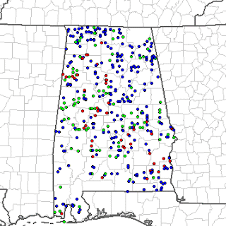
Alabama, like much of the South and Lower Mississippi Valley, is off to a very fast start in 2008 for tornadoes and severe weather. As of February 14, 2008 Alabama has already had the following severe weather reports, according to the Storm Prediction Center:
Tornadoes - 19
Hail - 11
Wind - 78
Total - 110
The SPC map below shows severe reports from Jan.1, 2008-Feb. 14, 2008:
Hail=green, Wind=blue, Tornado=red
Keep in mind that January and the first half of February are typically not the most active months and that the above figures do not include the tornadoes and other reports from the February 17 outbreak yesterday.
Alabama has been in a relative "drought" for tornadoes over the past 10-15 years, especially during the late winter and spring tornado season. Most of our major tornado activity has been during the month of November. In 2007, Alabama had the following severe reports according to the SPC:
Tornadoes - 68
Hail - 143
Wind - 296
Total - 509
The SPC map below shows severe reports in Alabama for 2007:
Hail=green, Wind=blue, Tornado=red
Unfortunately, Alabama is way ahead of our pace from last year and there is no end in sight. As we approach the primary severe weather season in this state, models seem to be indicating that there will be a series of storms approaching every few days. Severe weather may be a threat again this Friday and Tuesday of next week.
This is Severe Weather Awareness Week in Alabama. If the events of the past few weeks have not made Alabamians aware of severe weather, I shudder to think what will.
If you are from North Alabama, consider joining me for Skywarn training. I will be attending training tomorrow night in Hartselle in Morgan County.
Here is a link to several more pictures of damage in Prattville and some aerial shots from Alabamawx.com and below is a video from the Associate Press.
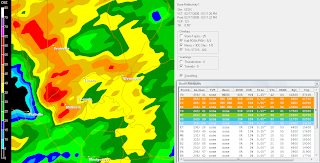
Storm survey data rolling in this afternoon...
PUBLIC INFORMATION STATEMENT NATIONAL WEATHER SERVICE BIRMINGHAM AL 100 PM CST MONDAY FEB 18 2008
...DAMAGE SURVEYS UNDERWAY ACROSS CENTRAL ALABAMA...
ON SUNDAY FEBRUARY 17, 2008 A STRONG UPPER LEVEL LOW EJECTED OUT OF THE SOUTHERN PLAINS TRACKING ACROSS THE TENNESSEE VALLEY. STRONG SOUTHERLY WINDS IN CONJUNCTION WITH DEWPOINTS CLIMBING INTO THE LOWER 60S...A STRONG LOW LEVEL JET...AND TEMPERATURES IN THE IN EXCESS OF 70 DEGREES RESULTED THE DEVELOPMENT OF SEVERAL SUPERCELL THUNDERSTORMS.
BEFORE NOON A SQUALL LINE DEVELOPED ALONG THE ALABAMA MISSISSIPPI STATE LINE AND TRACKED EASTWARD ACROSS CENTRAL ALABAMA...INTENSIFYING DURING THE AFTERNOON HOURS. BY SUNSET...DAMAGE WAS REPORTED AT NUMEROUS LOCATIONS...GENERALLY ALONG AND SOUTH OF A LINE FROM DEMOPOLIS TO WEDOWEE.
TORNADO WATCHES WERE IN EFFECT FOR PORTIONS OF CENTRAL ALABAMA BETWEEN 530 AM AND 8 PM. A TOTAL OF 20 TORNADO WARNINGS AND 7 SEVERE THUNDERSTORM WARNINGS WERE ISSUED BETWEEN 10:59 AM AND 5:05 PM BY THE NATIONAL WEATHER SERVICE OFFICE IN BIRMINGHAM.
AUTAUGA COUNTY:A NATIONAL WEATHER SERVICE SURVEY TEAM IS IN THE PROCESS OFACCESSING THE DAMAGE IN AUTAUGA COUNTY. IT HAS BEEN DETERMINED THE DAMAGE WAS THE RESULT OF A TORNADO...RANKING EF-3 ON THE ENHANCED FUJITA SCALE. A TOTAL PATH LENGTH IS YET TO BE DETERMINED...BUT THE DAMAGE PATH IS 450 YARDS WIDE AT ITS WIDEST POINT. THE MOST DAMAGE OCCURRED ALONG EAST MAIN STREET NEAR MCQUEEN SMITH ROAD AND IN THE SILVER HILLS SUBDIVISION. AN ESTIMATED 200 RESIDENTIAL HOMES AND 40 BUSINESSES WERE DAMAGED OR DESTROYED. HUNDREDS OF TREES WERE EITHER SNAPPED OR UPROOTED. IN ADDITION...50 INJURIES WERE REPORTED. WINDSPEEDS ARE ESTIMATED TO BE UP TO 150 MILES PER HOUR. THIS DAMAGE OCCURED AT APPROXIMATELY 305 PM. A TORNADO WARNING WAS IN EFFECT FROM 2:31 PM UNTIL 3:30 PM.
CHILTON COUNTY: A NATIONAL WEATHER SERVICE SURVEY TEAM HAS ASSESSED THE DAMAGE NEAR EXIT 205 ALONG INTERSTATE 65 IN CHILTON COUNTY. IT WAS DETERMINEDTHAT THE MAJORITY OF THIS DAMAGE WAS THE RESULT OF STRAIGHT LINE WINDS. THIS DAMAGE ENCOMPASSED AN AREA NEARLY 2.75 MILES LONG BY 1.5 MILES WIDE BETWEEN COUNTY ROAD 7 AND COUNTY ROAD 41. HOWEVER THE SURVEY ALSO INDICATED A LOCALIZED AREA EAST OF INTERSTATE 65 WAS THE RESULT OF A TORNADO RATED EF-1 ON THE ENHANCED FUJITA SCALE. WINDS ARE ESTIMATED TO BE UP TO 110 MPH. THE DAMAGE PATH WAS 1.1 MILES LONG AND 0.25 MILES WIDE AT ITS WIDEST POINT. DAMAGE WAS PRIMARILY TO TREES...APPROXIMATELY 300 TREES WERE EITHER UPROOTED OR SNAPPED. IN ADDITION...AROUND 15 STRUCTURES WERE DAMAGED...THE WORST BEING A MOBILE HOME ALONG COUNTY ROAD 41 THAT HAD TWO LARGE OAK TREES FALL ON IT. THIS DAMAGE OCCURRED AT APPROXIMATELY 1:05 PM. TWO TORNADO WARNINGS WERE ISSUED FOR THIS STORM. THE FIRST WAS ISSUED AT 1208PM AND EXPIRED AT 1:00 PM. THE SECOND TORNADO WARNING WAS ISSUED AT 12:53 PM AND EXPIRED AT 1:30 PM. IN ADDITION...A SEVERE THUNDERSTORM WARNING WAS ISSUED AT 12:28 PM AND EXPIRED AT 1:30 PM. NO INJURIES WERE REPORTED.
DALLAS COUNTY: A NATIONAL WEATHER SERVICE SURVEY TEAM HAS ASSESSED THE DAMAGE IN DALLAS COUNTY AND DETERMINED THE DAMAGE WAS THE RESULT OF A TORNADO...RANKING EF-2 ON THE ENHANCED FUJITA SCALE. THE TORNADO PATH WAS APPROXIMATELY 7 MILES LONG AND 150 YARDS WIDE AT ITS WIDEST POINT. SEVEN HOMES AND TWO BUSINESSES WERE TOTALLY DESTROYED IN ADDITION TWELVE TO FIFTEEN ADDITIONAL STRUCTURES WERE DAMAGED TO VARIOUS DEGREES. NUMEROUS TREES WERE SNAPPED AND OR UPROOTED AS WELL. WIND SPEEDS ARE ESTIMATED TO BE AS HIGH AS 120 MPH. THIS TORNADO TOUCHED DOWN NEAR WARRIOR DRIVE...JUST SOUTHEAST OF THE PERRY COUNTY LINE...TRACKED ACROSS HIGHWAY 219 NEAR THE INTERSECTION OF COUNTY ROAD 230...AND ENDED JUST WEST OF THE INTERSECTION OFCOUNTY ROAD 37 AND COUNTY ROAD 866. THIS DAMAGE OCCURRED AROUND 1229 PM. A TORNADO WARNING WAS IN EFFECT FROM 12:08 PM UNTIL 1:00PM. NO INJURIES WERE REPORTED.
PIKE COUNTY: A NATIONAL WEATHER SERVICE SURVEY TEAM HAS ASSESSED THE DAMAGE IN PIKE COUNTY AND DETERMINED THE DAMAGE WAS THE RESULT OF A TORNADO...RANKING EF-1 ON THE ENHANCED FUJITA SCALE. THE TORNADO PATH LENGTH WAS APPROXIMATELY 8.2 MILES LONG (IN PIKE COUNTY) AND 200YARDS WIDE AT ITS WIDEST POINT. ONE HOME AND ONE CHURCH WERE DAMAGED AND NUMEROUS TREES WERE SNAPPED OR UPROOTED. WINDS ARE ESTIMATED TO BE UP TO 100 MPH. THE STORM ENTERED PIKE COUNTY FROM COFFEE COUNTY APPROXIMATELY 5 MILES SOUTHEAST OF HENDERSON...CROSSED STATE HIGHWAYS 87 AND 167 AND ENDED JUST NORTH OF THE INTERSECTION OF COUNTY ROADS 6 AND 57. IT SHOULD BE NOTED THAT THIS STORM TRACKED ACROSS COUNTIES IN BOTH MOBILE AND TALLAHASSEE AREA OF RESPONSIBILITY. THE FINAL EF RANKING AND PATH LENGTH/WIDTH WILL BE DETERMINED BY THE MAXIMUM RANKING FROM THE THREE OFFICES. THIS DAMAGE OCCURED AT APPROXIMATELY 223 PM. A TORNADO WARNING WAS IN EFFECT FROM 1:50 PM UNTIL 245 PM.
IF YOU ARE AWARE OF DAMAGE AT LOCATIONS OTHER THAN LISTED ABOVE...PLEASE CALL IN YOUR REPORT TO YOUR LOCAL LAW ENFORCEMENT OR YOUR COUNTY EMERGENCY MANAGEMENT OFFICE IF YOU HAVE NOT ALREADY DONE SO.
DAMAGE ASSESSMENT TAKES TIME AND IS A DYNAMIC PROCESS. THIS PRODUCT WILL BE UPDATED MANY TIMES. CHECK BACK FREQUENTLY FOR THE LATEST INFORMATION.
IF THERE ARE ANY QUESTIONS REGARDING SUNDAYS EVENTS OR OUR PLANS TO SURVEY ON MONDAY...PLEASE CONTACT THE POST EVENT COORDINATOR AT THE BIRMINGHAM NATIONAL WEATHER SERVICE OFFICE AT 205-664-3010.$$12/SIRMON
---
The NWS Birmingham is conducting storm surveys today. Here are some preliminary findings:
3 mi SE of Clanton, Chilton Co, AL, EF1 Tornado - 17 Feb, 01:10 PM CST -- A tornado touched down toward the end of a large downburst swath south of Clanton. The tornado started near exit 205 on Interstate 65 and ended along CR 41. One mobile home was destroyed and several other structures were damaged. Several trees and power lines were also blown down along the path.
6 mi NW of Selma, Dallas Co, AL, EF2 Tornado - 17 Feb, 12:29 PM CST -- A tornado affected county roads 843, 37, 16, Oakmulgee Road, and Centenary Road. Numerous trees were snapped off and uprooted along the path. At least 7 homes and 15 businesses were damaged or destroyed including Hughes Body Shop.
12 mi S of Troy, Pike Co, AL, EF1 Tornado - 17 Feb, 02:23 PM CST -- The beginning point of this tornado has yet to be determined in South Alabama. The tornado entered southern Pike county southwest of Henderson. The tornado ended near CR 6 and CR 57. At least one home and one church were damaged. Numerous trees were blown down along the path.
Quote from this morning's Montgomery Advertiser: "This was one of the most significant outbreaks in central Alabama in the past two or three years," said meteorologist Jason Wright, with the National Weather Service in Birmingham.
There are four photo galleries up from the Montgomery Advertiser as of 10 a.m.
This is coverage from ABC 33/40 out of Birmingham during and after the tornado. It is out of their DMA, but James Spann, Jason Simpson, and Ashley Brand did take a few looks at the storm.
Notice the Airlink 33/40 images at the end of the video. The damage was impressive with approximately 170 homes sustaining damage and 30 more being destroyed. It is amazing and miraculous that as of this writing, nine hours after the event, no fatalities have been reported.
---
I received the following comment from an eyewitness of the tornado on my YouTube channel this morning a little after 9:30:
"I work at the Wal-Mart and was inside the store when the tornado came through the city. I didn't have time to make it to the center of the store. One of my friends was actually stuck in her car in the parking lot when the tornado hit. I just thank the Good Lord that everybody made it out with their lives and my heart and prayers go out to everyone in P-Ville."
PUBLIC INFORMATION STATEMENT NATIONAL WEATHER SERVICE BIRMINGHAM AL 910 PM CST SUN FEB 17 2008
...DAMAGE SURVEYS TO BE CONDUCTED IN CENTRAL ALABAMA MONDAY...
NWS STORM SURVEY TEAMS WILL BE DISPATCHED FIRST THING IN THE MORNING MONDAY TO OFFICIALLY SURVEY STORM DAMAGE FROM SUNDAYS STORMS. AT FIRST GLANCE...IT APPEARS THAT THERE WERE AT LEAST 5 DAMAGE-PRODUCING SUPERCELL THUNDERSTORMS THAT TRACKED ACROSS THE SOUTHEASTERN THIRD OF CENTRAL ALABAMA SUNDAY AFTERNOON. ONE SUPERCELL TRACKED ALL THE WAY FROM SOUTHERN MARENGO COUNTY...TO CROSSING THE GEORGIA STATE LINE IN RANDOLPH COUNTY... PRODUCING SEVERAL DAMAGE REPORTS ALONG THE WAY.
WITH THE NUMEROUS DAMAGE REPORTS RECEIVED...IT WILL LIKELY TAKE TWO DAYS TO COMPLETE ALL THE NECESSARY SURVEYS. CURRENT PLANS FOR MONDAY ARE FOR 3 SURVEY TEAMS TO ASSESS DAMAGE ON THE GROUND...WITH ANOTHER PERSON CONDUCTING AN AERIAL SURVEY. AT THIS TIME... OUR PLAN IS TO SEND CREWS TO ASSESS POSSIBLE DAMAGE ALONG STORM TRACKS IN DALLAS/PERRY/MARENGO/AND CHILTON COUNTIES...LOWNDES/AUTAUGA/AND ELMORE COUNTIES...AS WELL AS PIKE/BARBOUR/AND RUSSELL COUNTIES. WE WILL ISSUE STATEMENTS ON SURVEY TEAM ASSESSMENTS AS SOON AS THEY ARE RECEIVED.
IF YOU ARE AWARE OF DAMAGE AT LOCATIONS OTHER THAN LISTED ABOVE...PLEASE CALL IN YOUR REPORT TO YOUR LOCAL LAW ENFORCEMENT OR YOUR COUNTY EMERGENCY MANAGEMENT OFFICE IF YOU HAVE NOT ALREADY DONE SO.
IF THERE ARE ANY QUESTIONS REGARDING SUNDAYS EVENTS OR OUR PLANS TO SURVEY ON MONDAY...PLEASE CONTACT THE POST EVENT COORDINATOR AT THE BIRMINGHAM NATIONAL WEATHER SERVICE OFFICE AT 205-664-3010.
--I will be uploading some video from coverage of this storm and it's aftermath soon--
This afternoon an apparently strong tornado touched down in Prattville, Alabama, which is just northwest of Montgomery, in Autauga County. According to the Montgomery Advertiser, it left a path of destruction that "started near the David D. Whetstone Complex, traveled northeast along County Road 4, hit the neighborhoods in and around the Overlook Subdivision and along Sheila and Memorial drives, cut through the Premier Place shopping center and slammed into two apartment complexes located behind Wal-Mart."
The most recent news reports are saying that there have been 29 people injured, two of which were critical. No fatalities have been reported. According to the Advertiser,"Larry Davis, manager of Autauga County Emergency Management Agency, said one of the critical injuries was a man who was eating at Sonic when the tornado hit. Rescue workers had to extricate him from his Ford Explorer. He was transported to Prattville Baptist."
The fact that there have been no fatalities and two critical injuries is amazing considering that 200 homes were damaged, 30 of which were actually destroyed, according to Prattville mayor Jim Byard.
Montgomery Advertiser video from Cobbs Ford Road in Prattville after a tornado swept through on Sunday, Feb. 17, 2008.
According to the AP, "a 35-bed mobile hospital unit was set up outside a Kmart to treat victims with minor to moderate injuries so that hospitals could take those with serious injuries, Dr. Steve Allen said. David Shoupe, 18, assistant manager at Palm Beach Tan, said he and a co-worker barely made it into a laundry room before the roof fell in and the wind tossed shopping carts aloft. "Soon as we turned the corner, the roof collapsed everywhere except the laundry room," Shoupe said, standing beside his white Lexus, with a front windshield cracked by debris and the other windows shattered."
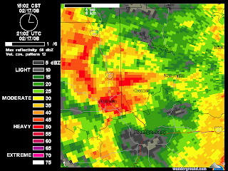
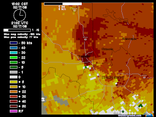
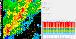
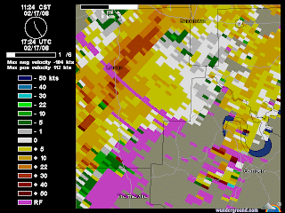
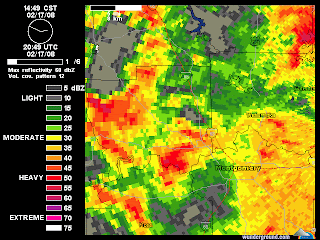
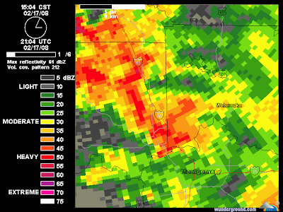
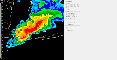
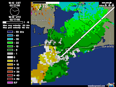
The image to the left is a time lapse view of the mesocyclone that produced the Prattville tornado from the Weatherunderground radar site. It begins at 2:49 and ends at 3:15 CT. Click on the image to show the animation.
"PRATTVILLE, Ala. - The mayor of a town nearMontgomery, Ala., says a tornado has destroyed numerous homes and may have trapped victims in the wreckage.
Homes were reported destroyed by Sunday's storms elsewhere inAlabamaand in theFlorida Panhandle.
THIS IS A BREAKING NEWS UPDATE. Check back soon for further information. AP's earlier story is below."
Tornado Warning Autauga, Elmore, Lowndes and Montgomery Counties
5 Nne Lowndesboro [Lowndes Co, AL] emergency mngr reports TORNADO at 02:48 PM CST -- possible tornado in northeast lowndes county...powerlines down and mobile homes damaged.
(15:15:22)Prattville [Autauga Co, AL] emergency mngr reports TORNADO at 03:10 PM CST -- powerlines on cars in the city...apartment complex damaged on county road 4. (15:15:59)....injuries reported ...Elmore Co
Millbrook [Elmore Co, AL] emergency mngr reports TORNADO at 03:15 PM CST -- tornado reported on the ground along county road 143
.--Major damage on Cobbs Ford Road in the East part of Prattville...Office Depot extensively damaged...per WSFA
---
I will be back later with much more information on what appears to be an outbreak of tornadoes through many areas in South and East Alabama...
Listen to WSFA in Montgomery for streaming audio/video...
In Pike County, the EMA reports damage at 12:43 p.m. from a possible tornado. It happened 5 miles SE of the community of Goshen. A possible tornado caused some road damage in the Henderson community.
(14:49:50)8 S Troy [Pike Co, AL] airplane pilot reports TORNADO at 02:30 PM CST -- possible tornado touchdown in spring hill.
Storm reports - Central Alabama
From J.B. Elliott:
* Tornado Warning continues for parts of Chilton, Coosa and Elmore Counties until 2:00 p.m.
* Tornado Warning expired at 1:30 for Autauga and Dallas Counties.
* Severe Thunderstorm Warning for St. Clair County no longer in effect.
* Severe Thunderstorm Warning until 2:30 p.m for Calhoun, Clay, Cleburne, Coosa, Randolph and Talladega Counties.
* 1:05 p.m. a tornado was reported on the ground at Rockford in Coosa County.
* Tornado Warning for Chambers, Clay, Coosa, Randolph and Tallapoosa Counties until 2:15 p.m.
* At 12:00 noon, a funnel cloud was reported just SW of Billingsley High School in Autuaga County by a trained spotter.
* At 12:18 p.m., trees and power lines down on County Road 37 10 miles south of Clanton in Chilton County.
* At 1:05 p.m., trees and power lines were also reported down in the city of Clanton.
* At 1:20 p.m, trees and power lines down in the city of Verbena in Chilton County.
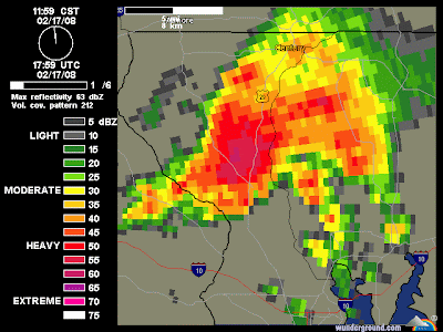
LARGE OAK TREES ACROSS THE ROAD AND POWERLINES DOWN CAUSING SOME OF THE RESPONDERS TO HAVE DIFFICULTY GETTING TO AFFECTED AREAS
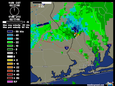
11:59-12:23 CT
11:59-12:23 CT
THIS TORNADO HAS PRODUCED STRUCTURAL DAMAGE. MORE DETAILS AS THEY BECOME AVAILABLE. AT 1209 PM CST...A TORNADO WAS ON THE GROUND NEAR CHUMUCKLA...OR ABOUT 24 MILES NORTH OF PENSACOLA...MOVING NORTHEAST AT 30 MPH. THE TORNADO WILL BE NEAR... 7 MILES NORTHWEST OF ALLENTOWN AND 9 MILES NORTHWEST OF MILTON NEAR WHITING FIELD BY 1230 PM CST... BERRYDALE BY 1240 PM CST... 8 MILES NORTHWEST OF MUNSON BY 1245 PM CST...
4 HOUSES REPORTED DESTROYED IN MOLINO. NO INJURIES REPORTED
TORNADO REPORTED ON THE GROUND BY MOLINO FIRE DEPARTMENT AND RELAYED THROUGH E-911 CENTER
TORNADO WARNING
NATIONAL WEATHER SERVICE BIRMINGHAM AL
1140 AM CST SUN FEB 17 2008

THE NATIONAL WEATHER SERVICE IN BIRMINGHAM HAS ISSUED A

* TORNADO WARNING FOR...
SOUTHWESTERN PERRY COUNTY IN CENTRAL ALABAMA...
WEST CENTRAL DALLAS COUNTY IN SOUTH CENTRAL ALABAMA...
SOUTHEASTERN MARENGO COUNTY IN SOUTHWEST ALABAMA...

* UNTIL 1215 PM CST

* AT 1140 AM CST...NATIONAL WEATHER SERVICE DOPPLER RADAR INDICATED A
SEVERE THUNDERSTORM CAPABLE OF PRODUCING A TORNADO NEAR MAGNOLIA...
OR 12 MILES SOUTHEAST OF LINDEN...MOVING NORTHEAST AT 50 MPH.

* THE TORNADO WILL BE NEAR...
CONSUL AND THOMASTON BY 1150 AM CST...
6 MILES NORTHWEST OF SAFFORD BY NOON CST...
VALDEN BY 1215 PM CST...

A SECOND POTENTIAL TORNADIC STORM WAS LOCATED SOUTH OF OPINE AND
WILL MOVE INTO SOUTHERN MARENGO BETWEEN SWEET WATER AND SURGINER BY
NOON.
THIS TORNADO HAS PRODUCED STRUCTURAL DAMAGE. MORE DETAILS AS THEY BECOME AVAILABLE. AT 1209 PM CST...A TORNADO WAS ON THE GROUND NEAR CHUMUCKLA...OR ABOUT 24 MILES NORTH OF PENSACOLA...MOVING NORTHEAST AT 30 MPH. THE TORNADO WILL BE NEAR... 7 MILES NORTHWEST OF ALLENTOWN AND 9 MILES NORTHWEST OF MILTON NEAR WHITING FIELD BY 1230 PM CST... BERRYDALE BY 1240 PM CST... 8 MILES NORTHWEST OF MUNSON BY 1245 PM CST...
---
TORNADO WARNING FOR... CENTRAL ESCAMBIA COUNTY IN NORTHWEST FLORIDA... SANTA ROSA COUNTY IN NORTHWEST FLORIDA... EAST CENTRAL BALDWIN COUNTY IN SOUTHWEST ALABAMA... * UNTIL 1245 PM CST * AT 1145 AM CST...NATIONAL WEATHER SERVICE DOPPLER RADAR INDICATED A SEVERE THUNDERSTORM CAPABLE OF PRODUCING A TORNADO NEAR BARRINEAU PARK...OR ABOUT 21 MILES NORTHWEST OF PENSACOLA...MOVING NORTHEAST AT 35 MPH. * THE TORNADO WILL BE NEAR... MOLINO...COTTAGE HILL AND 9 MILES NORTHWEST OF GONZALEZ BY 1155 AM CST... CHUMUCKLA BY 1205 PM CST... ALLENTOWN AND 7 MILES NORTHWEST OF MILTON NEAR WHITING FIELD BY 1220 PM CST... BERRYDALE BY 1230 PM CST... MUNSON BY 1240 PM CST...
---
According to WALA-10, The one that went into Weeks Bay, a waterspout was reported and came ashore. But no damage.
11:17
A TORNADO WARNING REMAINS IN EFFECT UNTIL NOON CST FOR EAST CENTRAL BALDWIN COUNTY... AT 1117 AM CST...NATIONAL WEATHER SERVICE DOPPLER RADAR CONTINUED TO INDICATE A POSSIBLE TORNADO. THIS TORNADO WAS LOCATED NEAR SUMMERDALE AND WAS MOVING NORTHEAST AROUND 30 MPH. THE CIRCULATION IS REFORMING AND THE PARENT STORM IS STRENGTHENING. THE POTENTIAL FOR THIS STORM TO PRODUCE A TORNADO WILL REMAIN HIGH THROUGH NOON...IF ONE HAS NOT ALREADY YET FORMED. THE TORNADO WILL BE NEAR... 6 MILES SOUTHEAST OF ROSINTON BY 1125 AM CST... ELSANOR BY 1130 AM CST... 8 MILES NORTHWEST OF SEMINOLE BY 1140 AM CST... 7 MILES SOUTHEAST OF GATESWOOD BY 1150 AM CST...
---
Tornado reported in Fort Morgan earlier by Baldwin Co Sheriff according to ABC 33/40 skywatcher...
---
Ham radio reported a funnel cloud south of Robertsdale.
---
AT 1108 AM CST...NATIONAL WEATHER SERVICE DOPPLER RADAR INDICATED A SEVERE THUNDERSTORM CAPABLE OF PRODUCING A TORNADO NEAR MARLOW MOVING NORTHEAST AROUND 40 MPH. THE CENTER OF CIRCULATION APPEARS TO BE RE-DEVELOPING. * THE TORNADO WILL BE NEAR... ROBERTSDALE BY 1120 AM CST... ELSANOR AND ROSINTON BY 1125 AM CST... GATESWOOD BY 1135 AM CST... BARRINEAU PARK BY 1140 AM CST...
---
At 1054 AM CST... Doppler Weather Radar Indicated A Possible Tornado About 8 Miles Southwest Of Mouth Of Weeks Bay... Moving Northeast At 15 To 20 Mph.
The Tornado Will Be Near... Mouth Of Weeks Bay... Turkey Branch... 6 Miles Southwest Of Magnolia Springs And 9 Miles Southwest Of Marlow By 1115 AM CST...
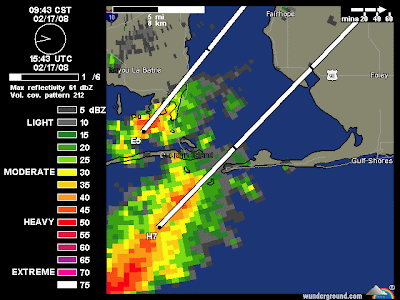
10:40
10:40
Pink Pony webcam in Gulf shores, looking west at approx 10:45 a.m.
BULLETIN - EAS ACTIVATION REQUESTED
TORNADO WARNING
NATIONAL WEATHER SERVICE MOBILE AL
1037 AM CST SUN FEB 17 2008

THE NATIONAL WEATHER SERVICE IN MOBILE HAS ISSUED A

* TORNADO WARNING FOR...
SOUTHWESTERN BALDWIN COUNTY IN SOUTHWEST ALABAMA...

* UNTIL 1115 AM CST

* AT 1035 AM CST...NATIONAL WEATHER SERVICE DOPPLER RADAR INDICATED A
SEVERE THUNDERSTORM CAPABLE OF PRODUCING A TORNADO NEAR FORT
MORGAN...OR ABOUT 6 MILES SOUTHEAST OF DAUPHIN ISLAND...MOVING
NORTHEAST AT 30 MPH.

* THE TORNADO WILL BE NEAR...
8 MILES NORTHWEST OF PALMETTO BEACH AND 8 MILES NORTHWEST OF GASQUE
BY 1055 AM CST...
TURKEY BRANCH...MOUTH OF WEEKS BAY AND POINT CLEAR BY 1110 AM
CST...
MARLOW...MAGNOLIA SPRINGS...HOUSTONVILLE AND 6 MILES SOUTHEAST OF
BATTLES WHARF BY 1115 AM CST...
I have been posting about Alabama weather on this blog since April 2006. Here you will find my observations, information provided by the NWS, links to quality weather information from other sources, and historical weather data. Please "follow" me on Twitter and join my "fan" page on Facebook. Twitter and Facebook posts are usually more current/breaking news. I appreciate your visit. Enjoy and come back soon. Thank you!
Follow @bamawx
Bamawx.com - Mike Wilhelm's Alabama Weather Blog on Facebook
Bamawx.com - Mike Wilhelm's Alabama Weather Blog on Facebook
Frosty Morning and an Extraordinary Land Breeze - Much of the state experienced a hard freeze last night, a combination of unusually cold air and clear skies, which allowed the earth to radiate heat to spa...
7 hours ago
Jon Davies Severe Weather Notes
March 25, 2021 deadly tornado outbreak in Alabama and Georgia - One week ago today, a deadly tornado outbreak in Alabama (AL) and Georgia (GA) caused 6 deaths and a number of injuries, making it the deadliest tornado ...
1 week ago
The Flight of a South Georgia Storm Chaser
That's why everybody advises me this - That's exactly what I wanted! http://link.denaliatving.com Jennifer
2 years ago
MWN Blog
June 2017 Climate Data for Memphis, TN - June Climate RecapFor the first time in recent memory, Memphis International Airport experienced consecutive months of below average temperatures in May an...
3 years ago
Dr. Jeff Masters' WunderBlog
Meteorology of Saturday's Colombian Flood Disaster That Killed 254 - At least 254 people were killed in the in the city of Mocoa (population 40,000) in southwest Colombia near the border of Ecuador early Saturday, when torre...
4 years ago
The Weather Guy
- Since 2014 the Cookeville Weather Guy has taken a hiatus from posting. At some point in the very near future he will resume. For now you can access his Fac...
4 years ago
Severe Plains
Thanksgiving Cleanup - Mild temperatures and an ambitious brother-in-law meant the opportunity to continue the cleanup of Cedar trees in the rear of the property. With loppers, h...
4 years ago
Tennessee Valley Weather
- I'm very sorry, but this blog has finally kicked the bucket. An informal weather blog will be kept at www.thatweatherblog.blogspot.com, as I have the time,...
6 years ago
EYE OF THE STORM
So... You want to chase a tropical cyclone? - ANYONE that wants to chase a hurricane/typhoon/cyclone should watch this. This is as real as it gets! Thankfully Jim made it through Super Typhoon Haiy...
7 years ago
Iowa WX
Grinnell F3 Tornado of 1978 - This may not be the season for tornadoes and we’ve seen in the past that tornadoes can occur at any time no matter what the calendar says. One such occurre...
7 years ago
WeatherScout
Agilent Indonesia 35670A FFT Dynamic Signal Analyzer - Agilent Indonesia 35670A 2 or 4 channel FFT Dynamic Signal Analyzer, DC-102.4 kHz Description The Agilent 35670A is a versatile FFT analyzer with built in ...
7 years ago
Prairiestorm Media Blog
sky drama - Haven't released anything officially, but for the sake of updating... if you're coming here looking for recent posts, STOP. Sky Drama is coming.
8 years ago
Storm Chasing Mikey
Hurricane Sandy - Hurricane Sandy Intensifies Over Jamaica Hurricane Sandy did not disappoint and has indeed become the Historic Storm we started watching on long range fore...
8 years ago
SOUTHERN WEATHER BRIGADE
Virginia Lightning - On Wednesday May 23rd, we had a very isolated cell with a strong hail core move up from North Carolina into Southeastern Virginia around 10:30pm est. I lo...
8 years ago
Justyn Jackson's Weather Blog
Dual-Pol Applications - Dual-pol installations are now being pushed in full force across the country. As of this post, eight radars are equipped with dual-pol, including the proto...
9 years ago
Southwest Georgia Stormtrack
A reminder......... - I work hard and go to considerable expense to capture my work. So please consider this before stealing any of my work. If you do, I will find you and the ...
9 years ago
High Plains Drifter
test image - this is only a test
9 years ago
Alaska Weather Blog
Tuesday March 8, 2011 - Things are really warming up right now! I know that sounds funny, especially since temps are still below freezing, however with the additional daylight (10...
10 years ago
Dan's Wild Wild Weather Journal
Did The Press Miss the Boat on The Black Hole Story?? - This page will soon no longer be updated- go to the new home at THE AGU BLOGOSPHERE You likely heard about it a few days ago. NASA announced the detection ...
10 years ago
Iowa Chaser
NEW BLOG -- Update Link - The Iowa Chaser blog is now the Severe Plains blog! All of the previous posts have been moved, and additional posts since December have been added to the n...
11 years ago
The Long Distance Chase Team...
Best of Hurricane Video!!! - Sorry it took me so long, but I finally put up the Best of Hurricane Video on youtube... It's from Hurricanes Ike, Rita, and Katrina... Honestly words can...
11 years ago
Nikki-Dee’s
*Your Baghdad Weather Glance* -
11 years ago
Tommy Self's North Alabama Weather Blog
Vortex 2 - Well it has been kinda dull weather wise around here the last few days so I turn my attention to the plains and the great tornado hunt.Looks like they ...
11 years ago
WSFA 12 Weather Blog
-
NSSTC Collaborative Weather Blog
-
Green Screen Weather
-
Severe Storm & Hurricane Video & Pictures, Florida Weather, Stock Footage, Storm Chaser Jeff Gammons - Weatherzine.Net