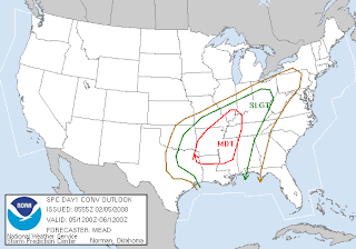
The SPC has issued a moderate risk for much of Arkansas, North Mississippi, West Tennessee, and surrounding areas. The western two thirds of Alabama are under a slight risk.
Models continue to slow this system down. The main squall line associated with this storm system will move through Alabama during the pre dawn hours Wednesday morning, which is the time of the day with the least instability. Some supercells will form ahead of the line to our west producing tornadoes.
Supercells are possible in Alabama but not as likely. The sounding from Birmingham shows a warm air "cap" in place. As long as skies remain cloudy today, chances of severe weather will be limited.
I will post more later today as the system develops. People should definitely be prepared for the possibility of severe weather this afternoon and overnight.


No comments:
Post a Comment