Wednesday, January 31, 2007

Midnight Update


Midnight report from Vinemont: Moderate sleet, Temp: 31.8, depoint 21.7

At 12:25 sleet is heavy in Vinemont and accumulating more rapidly. Sleet is beginning to accumulate on the street and the temperature continues to fall ever so gradually. It's now 31.3.

At 12:35 it is mostly heavy sleet with a few flakes mixed in.

At 12:50 we had heavy sleet with some big snowflakes mixed in. The temp has dropped to 30.9.

Additional Reports From our Friends, Bill Murray

11 PM Update


This photo doesn't do it justice, but it was snowing pretty good around 11, with sleet mixed.


Moderate sleet and snow at 11 in Vinemont.

Temp is 32.5 at 11:20

At 11:33: The NWS site at the Cullman Airport in Vinemont was reporting partly cloudy and 36 a few minutes ago. They are only a few miles from where I live. Now they say 36 with light snow. They are right about the snow, but it’s 32.4 here and there is no way it is 36 there.

At 11:37 we have alternated back to mostly moderate sleet with a few flakes of snow mixed in. It had been predominately snow. The temp has dropped to 32.2 now.

Late Reports - Bill Murray

Heavy sleet, no snow mixed, and 32.0 in Vinemont at 11:45. Accumulating on elevated surfaces, melting slowly on roads.

10 PM Update


Doppler 48 Radar at 9:55.

Still sleet and light snow at 10:09 here in Vinemont. It is still 33 degrees.

Light snow in Vinemont at 10:30. No sleet.

More Updates


Radar at 9:38

Sleet on 278 west of Cullman at 9:56.
Sleet and light snow in Vinemont at 9:58. Temp 33.3

More Updates


Radar at 9:38

Weather Update 9 p.m.


Radars from WAFF 48 and ABC 33/40 just before 9 p.m. The temp is 32.5 in Vinemont at 9 p.m.

At 9:23, Doppler 48 shows the leading edge of the prcip moving into west and SW Cullman Co. The temp is now 32.9.

Alabama Weather Update, Bill Murray

Here Comes the Sleet


Winter weather has begun with reports of sleet in portions of Pickens, Fayette, Tuscaloosa, Jefferson, Chilton and Shelby Counties. Radar from ABC 33/40 shows the precip moving in. The temperature is now 33.7 in Vinemont. The dewpoint is 16.1.

Evening Alabama Update 6:45 by JB Elliott

Sleet Reaching the Ground by JB Elliott

Update at 7:45 for Sleet Reports by JBE

More Sleet Reports 8PM, JBE

Today's Low

The low this morning in Vinemont finally dipped to 13.6. We are now on our way up at 14.0.

Snow, Ice, and Rain - Tonight and Tomorrow

As mentioned over a week ago, we are encountering a major cold spell with occasional winter weather threats. Tonight is our first threat of significant problems with ice or snow this winter.

It will be interesting to see how long this cold, dry air can fight it out with the precip. It's down to 14.0 as of 6:25 this morning here in northern Cullman County. Even if the low tracks close to us, it seems like the chance of sleet and freezing rain is pretty significant across north Alabama. What if it tracks 50 miles further south?

My thought at this point is that the precipitation will begin as virga (not reaching the ground). You may see the radar showing precipitation at tonight at 8:00, but it won't be reaching the ground. That will aid evaporational cooling, dropping the temperature and raising the dewpoints. Between 9 and midnight precipitation will begin spreading across the state. In Central Alabama it will bring a period of sleet and freezing rain. Temperatures in the Tennessee Valley will be low enough higher in the atmosphere to support snow initially.

I am confident about how the precipitation will start. I am not as confident about when and if it will change to rain in specific parts of North Alabama. That depends on many factors, such as: the amount of sunshine and warming we get today, how much evaporative and radiational cooling occurs this evening, and, perhaps most importantly, the track of the low pressure.

At this point, the National Weather Service is expecting it to change over to rain before ending. That might occur, but I am not as confident about that yet. Keep a close eye on the position of the center of the low pressure. The further south it remains will result in less rain and more frozen precipitation.

As with all weather forecasts, expect the unexpected!

Another Cold Morning

The temperature has dropped to 14.4 so far this morning here in Vinemont in northern Cullman County.

From the NWS Huntsville

Area Forecast Discussion
000
FXUS64 KHUN 311112
AFDHUN

AREA FORECAST DISCUSSION
NATIONAL WEATHER SERVICE HUNTSVILLE AL
510 AM CST WED JAN 31 2007

.DISCUSSION...
THE DISCUSSION THIS MORNING WILL FOCUS ON THE NEAR TERM FORECAST FOR TONIGHT INTO THURSDAY WHICH TOOK CONSIDERABLE TIME TO FORMULATE.
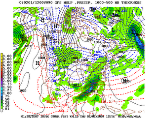
THE NAM AND GFS MODELS HAVE TRENDED TOWARD A COLDER SOLUTION THE LAST TWO RUNS. A VERY COLD ARCTIC AIR MASS HAS MOVED INTO PLACE OVER
THE TN VALLEY AND WILL BE OVERRUN LATER THIS EVENING BY A DEEP LAYER OF MOIST AIR. SUCH A QUICK OVERRUNNING OF A VERY COLD AIR MASS IS
FAVORABLE FOR A SIGNIFICANT WINTER WEATHER EVENT ACROSS NORTHERN AL AND PARTS OF SOUTHERN MIDDLE TN.

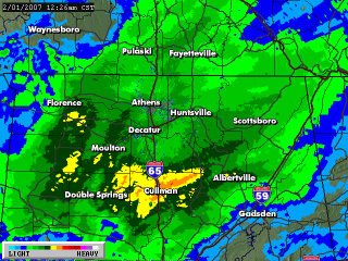
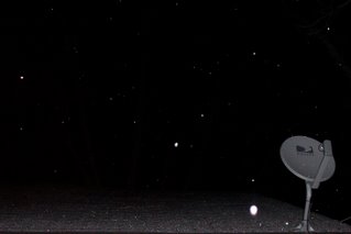
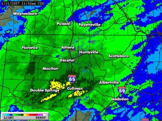
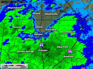
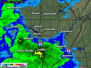
PRECIPITATION WILL SPREAD FROM SOUTHWEST TO NORTHEAST ACROSS THE AREA LATE THIS EVENING...FROM 9 OR 10 PM THROUGH MIDNIGHT. THE
ATMOSPHERE WILL BE COLD ENOUGH FOR MOST OF THE PRECIPITATION TO START AS SNOW. THE SNOW WILL MIX WITH OR CHANGE TO SLEET OR FREEZING
RAIN SOUTH AND WEST OF THE HUNTSVILLE AREA AFTER 3 AM....WITH A COMPLETE CHANGEOVER TO RAIN EXPECTED AROUND DAYBREAK. FOR NORTHEAST
ALABAMA AND SOUTHEAST MIDDLE TENNESSEE...THE PRECIPITATION SHOULD REMAIN AS MOSTLY SNOW... WITH SOME SLEET OR FREEZING RAIN POSSIBLY
MIXING WITH THE SNOW IN NORTHEAST ALABAMA AROUND 6 AM. LIGHTER MIXED PRECIPITATION WILL FALL EARLY THURSDAY MORNING BEFORE CHANGING OVER TO ALL RAIN.

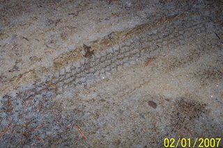
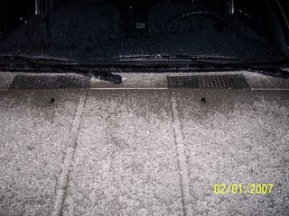
UNDER THIS SCENARIO...UP TO 1 INCH OF SNOW AND SLEET ACCUMULATIONS WOULD BE POSSIBLE FOR NORTHWEST ALABAMA AND CULLMAN COUNTY...AND
UP TO 1/10 OF AN INCH OF ICE ACCUMULATION. NORTH AND EAST OF HUNTSVILLE...1 TO 2 INCHES OF SLEET AND SNOW WILL BE POSSIBLE WITH PERHAPS A LIGHT GLAZE OF ICE EXPECTED. THE PRECIPITATION SHOULD
CHANGE TO ALL RAIN OVER THE WHOLE AREA BY NOONTIME.

WHILE OVERALL CONFIDENCE IN THE WINTER WEATHER HAS INCREASED... CONFIDENCE IN THE EXACT PRECIPITATION TYPES...TIMING...AND AMOUNTS
REMAINS LOW. AS WITH MOST WINTER SYSTEMS IN THE TENNESSEE VALLEY... SMALL SHIFTS IN THE TEMPERATURES ALOFT WILL HAVE A GREAT IMPACT ON THE FORECAST.

A BRIEF REVIEW OF THE GFS MODEL FOR FRIDAY AND BEYOND INDICATED LITTLE CHANGE FROM PREVIOUS FORECASTS. THE CENTRAL AND EASTERN CONUS
WILL REMAIN UNDER A TROUGH ALOFT WITH UNSEASONABLY COLD TEMPERATURES CONTINUING THROUGH NEXT TUESDAY.

-----

409 AM CST WED JAN 31 2007

...WINTER WEATHER ADVISORY IN EFFECT FROM 9 PM THIS EVENING TO 6 AM CST THURSDAY...

THE NATIONAL WEATHER SERVICE IN HUNTSVILLE HAS ISSUED A WINTER WEATHER ADVISORY...WHICH IS IN EFFECT FROM 9 PM THIS EVENING TO 6 AM CST THURSDAY.

PRECIPITATION WILL BEGIN ACROSS NORTHEAST ALABAMA AND PORTIONS OF SOUTHERN MIDDLE TENNESSEE LATE THIS EVENING...AND INITIALLY WILL FALL AS LIGHT SNOW. SNOWFALL OF ONE TO TWO INCHES CAN BE EXPECTED DURING THE OVERNIGHT HOURS. WARMING ALOFT MAY CAUSE THE SNOW TO MIX WITH SLEET OR FREEZING RAIN AROUND DAYBREAK ACROSS NORTHEAST ALABAMA...PERHAPS PRODUCING A LIGHT GLAZE OF ICE...THEN CHANGE TO ALL RAIN SHORTLY AFTERWARDS.

A WINTER WEATHER ADVISORY MEANS THAT PERIODS OF SNOW...SLEET...OR FREEZING RAIN WILL CAUSE TRAVEL DIFFICULTIES. BE PREPARED FOR SLIPPERY ROADS AND LIMITED VISIBILITIES...AND USE CAUTION WHILE DRIVING.

STAY TUNED TO NOAA WEATHER RADIO...A FAVORITE LOCAL TELEVISION OR RADIO STATION...OR VISIT OUR WEBSITE AT WEATHER.GOV/HUNTSVILLE FOR THE LATEST ON THIS WINTER WEATHER EVENT.

Monday, January 29, 2007

As of 7 a.m.

It dropped to 12.9 here in Vinemont as of 7 a.m. That was our low for the day.

Here comes the cold...


As promised, we've dropped into the deep freeze here in North Alabama. As of 6:15 this morning, the ole thermometer reads 13.5 here in northern Cullman County. I think we need to drop 1/10th of a degree more so we can claim it was 13 instead of 14. Hey, if it's going to be this cold, what's 1/10th of a degree among friends?

Of further concern, this bitter cold isn't going away soon. Despite the fact that the Weather Channel and many others were forecasting highs in the 50's this week, it's becoming more apparent that this will not happen. We will have some reinforcing shots of cold air during the week. I would be surprised if we get out of the 40's this week. Some days we won't get out of the 30's.

In addition to the cold, a winter storm threat may be on the horizon Wednesday night into Thursday. As James Spann has been telling us for over a week, someone in the south will probably get hit. At the moment, the Tennessee Valley might be in the bull's eye.

More to come later!

Sunday, January 28, 2007

Cold Weather Update

The cold has hit! The temperature has been dropping since this time yesterday. We made it into the 50's yesterday. After the rain began in the evening we fell into the 40's. Around midnight we fell into the 30's and bottomed out this morning at 32. We never got above 37 this afternoon. Just days ago the Weather Channel and forecast models were saying we'd have highs in the 50's today. They were 25 degrees off. Now at 6:45 we have already dropped down to 28. We are on our way to the teens tonight.

Thursday, January 25, 2007

Weather Models

Below is a link for weather models, if you wish to get an update on the possiblility of a winter storm next Thursday or Friday.

http://www.nco.ncep.noaa.gov/pmb/nwprod/analysis/

There are four model runs each day:

00z= 6am
06z= midnight
12z= 6pm
18z= noon

-----

The GFS (Global Forecast System) model output illustrated below shows that temperatures will be cold enough to support frozen precipatation in the South as a low forms in the Gulf next week. In order for a significant winter storm to develop in Alabama, it would need to develop in this fashion. It's way too early to pinpoint where it will happen, but it sure seems like somewhere between Nashville and Montgomery could see a significant winter storm late next week. Looking farther out into "voodooland", as James Spann likes to call it, there may be another winter weather threat on the following Sunday.


High Confidence Cold Weather Forecast

Models continue to point to a change to bitter cold weather with some winter storm threats to the South. Eight days from now, on Thursday night/Friday morning of next week, someone in the south may have snow on the ground. James Spann mentioned this in his morning discussion:

"No doubt somebody south of the Mason-Dixon line will have a nice blanket of snow on the ground on Friday Feb 2… might be Nashville, Knoxville, Atlanta, Memphis, Birmingham, Montgomery, or Charlotte. Some snow lovers will be delighted, others will be disappointed. But, for those who don’t get it at the end of next week, there will be other chances down the line. And, I don’t even want to go there yet."

His complete discussion can be found here.

Wednesday, January 24, 2007

A new way of measuring weather in hurricanes?

Take a look at this site about Aerosondes.

According to the site:

"Small, robotic aircraft designed for collection of meteorological data over oceans and remote areas, the Aerosondes will operate over the North Atlantic Ocean taking observations in the lower atmosphere."

"Climate Scientists Feeling the Heat"

Has global warming been oversold? Excellent article from the Houston Chronicle.

Tuesday, January 23, 2007

Graphic on the winter threats ahead

Check this out from NOAA!

Outlook for COLD February 2-6

You heard it here second! I give credit to James Spann for this one. The models are showing a major change to bitter cold temperatures across the Eastern United States late next week. James Spann today said,

"The 00Z GFS is hinting at an historic period of brutally cold weather for much of the nation in the February 2-6 time frame, including Alabama. The 00Z run is showing 850 mb temps (5,000 feet off the ground) of -30 C as far south as the Tennessee Valley. Even if this is a gross error we will still have very, very cold air (I do think this run went a little overboard)."

I might add that the southern storm track has been very active this winter. If these two factors "phase up" then parts of the deep south may be in for a major winter weather threat sometime during the first two weeks of February.

As James likes to say, this is all way out there in "voodoo land" but it is definitely one of those situations that bears watching closely. I will not be surprised if the South encounters some historic bad winter weather conditions. Let's keep an eye on it.

Monday, January 22, 2007

Global Warming Controversy

The following is from the Washington Times. This editorial praised one of my heroes, James Spann of ABC 33/40 out of Birmingham and The Weather Company.

Nobles and Knaves Washington Times

Heidi Cullen's original blog entry that sparked this conversation

James Spann's entry

WeatherBrains Podcast

National Ledger

Fox News

Con Job at The Weather Channel

Saturday, January 20, 2007

Global Waming

I have written little about this subject on this blog because I think that it really requires a great deal of time to do it justice. It is such a multi-faceted issue, with regard to the challenges to science as well as the public debate.

During the past week, Heidi Cullen of The Weather Channel, reflecting a position held by many on the political left including Al Gore, attempted to discredit anyone who disagrees that there is such a thing as human-induced global warming. She went so far as to assert that any meteorologist who does not believe in human-induced global warming should be stripped of their license.

This has caused quite a firestorm of backlash among the public and from within the meteorological community. My favorite weather blog, Alabamawx.com was swamped with visitors and comments when James Spann spoke out against this radical point of view.

Here are some of the major questions to consider:

Can the scientific method be used to answer any of the following questions?

Does global warming exist?

If so, to what degree?

Can global tempreatures be measured reliably, over time?

How can the potential results of global climate change be predicted reliably?

If we conclude global warming is occuring, is it induced by human activity?

How can that be verified?

If it is caused by human activity, to what degree?

If global warming is occurring, and it is caused primarily by human activity, and the results of global warming can be predicted reliably, is it possible to effectively change human behavior?

What are the costs versus benefits of such changes?

To what degree does money and political ideology influence the scientific research and conclusions?

Should some scientists be silenced by stripping their license if they present dissenting views?

I will attempt to answer some of these questions in upcoming days. Comments are welcome!

Wednesday, January 17, 2007

Sleet

It's been sleeting, mostly light, here in Vinemont for about 30 minutes. the temperature is 37.

Brrr...

The low this morning was 24.1 in Vinemont.

Last week our highs were in the upper 60's and lower 70's. Yesterday the temperature hovered in the low 30's across North Alabama which was 40 degrees colder than most days during the last week. A major ice storm struck Texas, Oklahona, and Missouri this weekend. My son Joe reported seeing a few snow flurries yesterday morning here in Cullman County. Last night very light sleet was reported across central and southern Alabama.

We will be in for a very interesting ride during the next few weeks. Will this be the year be break our ice and snow drought? We may soon find out! From alabamawx.com:

Late Night Statement

A Few Ice Pellets

Alabama Early Wednesday

Sunday, January 14, 2007

Can you believe it?


Dafodills blooming in Alabama on January 14, 2007. This unseasonably warm weather is about to end, though, and so will these blooms.

Sunday, January 07, 2007

Wet Weather


Today we had a lot of clouds and some heavy rain as a line of stong to severe storms moved across the state. There were some damage reports in East Alabama and some of that damage may have resulted from tornadoes.

I also have not mentioned that last Friday there was some damage in west and Central Alabama, as well as in Mississippi and Louisiana. Some of that also was from tornadoes.

Updating and Recapping (1/7/07 fom Alabamawx.com)
Newer Posts Older Posts Home