Thursday, July 30, 2009

Strong Storms...


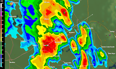
There were several strong to severe storms in Alabama this afternoon and evening. My son Joe and I photographed a few of them near West Pont in Cullman County around 6:30 p.m.

...

Severe Thunderstorm Watch


   URGENT - IMMEDIATE BROADCAST REQUESTED
SEVERE THUNDERSTORM WATCH NUMBER 642
NWS STORM PREDICTION CENTER NORMAN OK
540 PM CDT THU JUL 30 2009

THE NWS STORM PREDICTION CENTER HAS ISSUED A
SEVERE THUNDERSTORM WATCH FOR PORTIONS OF

MUCH OF NORTHERN AND CENTRAL ALABAMA
PARTS OF SOUTHERN MIDDLE TENNESSEE

EFFECTIVE THIS THURSDAY AFTERNOON FROM 540 PM UNTIL MIDNIGHT CDT.

HAIL TO 1.5 INCHES IN DIAMETER...THUNDERSTORM WIND GUSTS TO 70
MPH...AND DANGEROUS LIGHTNING ARE POSSIBLE IN THESE AREAS.

THE SEVERE THUNDERSTORM WATCH AREA IS APPROXIMATELY ALONG AND 60
STATUTE MILES EAST AND WEST OF A LINE FROM 45 MILES SOUTH
SOUTHEAST OF TUSCALOOSA ALABAMA TO 45 MILES NORTH OF HUNTSVILLE
ALABAMA. FOR A COMPLETE DEPICTION OF THE WATCH SEE THE
ASSOCIATED WATCH OUTLINE UPDATE (WOUS64 KWNS WOU2).

REMEMBER...A SEVERE THUNDERSTORM WATCH MEANS CONDITIONS ARE
FAVORABLE FOR SEVERE THUNDERSTORMS IN AND CLOSE TO THE WATCH
AREA. PERSONS IN THESE AREAS SHOULD BE ON THE LOOKOUT FOR
THREATENING WEATHER CONDITIONS AND LISTEN FOR LATER STATEMENTS
AND POSSIBLE WARNINGS. SEVERE THUNDERSTORMS CAN AND OCCASIONALLY
DO PRODUCE TORNADOES.

OTHER WATCH INFORMATION...CONTINUE...WW 639...WW 640...WW 641...

DISCUSSION...SQUALL LINE WITH EMBEDDED BOWS MOVING RAPIDLY ENEWD
ACROSS NRN MS INTO AL. WITH A VERY MOIST AND UNSTABLE AIR MASS
COUPLED WITH 30-35 KT OF SHEAR...POTENTIAL FOR DAMAGING WINDS WILL
CONTINUE ACROSS THE WATCH. ISOLATED SUPERCELLS ALSO POSSIBLE ALONG
AND AHEAD OF THE LINE WITH A THREAT OF BRIEF TORNADOES.

AVIATION...A FEW SEVERE THUNDERSTORMS WITH HAIL SURFACE AND ALOFT
TO 1.5 INCHES. EXTREME TURBULENCE AND SURFACE WIND GUSTS TO 60
KNOTS. A FEW CUMULONIMBI WITH MAXIMUM TOPS TO 500. MEAN STORM
MOTION VECTOR 24035.


...HALES

Severe Weather Possible


3:45 PM Columbus Nexrad

Severe weather, including a few isolated tornadoes is possible across Mississippi and Alabama this evening. Stay tuned to the weather.

Tuesday, July 28, 2009

Lightning!


I received this stunning picture from Betsy Sharp of WAY-FM in Huntsville. It was taken by her friend, Denise Durflinger, early this morning near Spokane, Washington.

...

Storms on the way


4:01 PM


3:43 PM

The SPC has placed much of Alabama under a slight risk for severe weather and there have been a few tornado warnings to our west.

SEVERE WEATHER STATEMENT
NATIONAL WEATHER SERVICE JACKSON MS
343 PM CDT TUE JUL 28 2009

MSC025-105-282115-
/O.CON.KJAN.TO.W.0091.000000T0000Z-090728T2115Z/
CLAY MS-OKTIBBEHA MS-
343 PM CDT TUE JUL 28 2009

...A TORNADO WARNING REMAINS IN EFFECT UNTIL 415 PM CDT FOR
NORTHEASTERN OKTIBBEHA AND SOUTHERN CLAY COUNTIES...

AT 343 PM CDT...NATIONAL WEATHER SERVICE METEOROLOGISTS CONTINUE TO
TRACK A SEVERE THUNDERSTORM CAPABLE OF PRODUCING A TORNADO. THIS
TORNADO WAS LOCATED JUST NORTH OF STARKVILLE MOVING EAST AT 25 MPH.

THE TORNADO WILL BE NEAR...
PALA ALTO BY 355 PM CDT...
MULDROW BY 400 PM CDT...
TIBBEE AND WEST POINT BY 410 PM CDT...
WAVERLY BY 415 PM CDT...

PRECAUTIONARY/PREPAREDNESS ACTIONS...

A TORNADO WARNING MEANS THAT A TORNADO IS OCCURRING OR IMMINENT. YOU
SHOULD ACTIVATE YOUR TORNADO ACTION PLAN AND TAKE PROTECTIVE ACTION
NOW.

&&

Rain is on the way....


6:41 am

As models have been showing for a while now, an unusually high amount of non-tropical rain (for late July) will be moving across the Deep South today and perhaps much of this week. Many areas will see several inches of rain.

Wednesday, July 22, 2009

Radar Anomalies


On July 9, 2009, I posed a question regarding what caused the above radar "spike" feature.

On July 10, 2009, I posted an answer that Bill Murray of the netcast "Weatherbrains" was able to find by speaking with a representative of the NWS Billings, Montana.

Thanks to Bill for digging deeper and getting a much more detailed response which was aired at the end of Episode 181 of Weatherbrains!

By the way it was also very nice that J.B. Elliott and Bill Murray mentioned my post on severe weather coverage at the end of Weatherbrains Episode 171.
...

Tuesday, July 21, 2009

Lightning at Orange Beach


This lightning shot was captured from video taken at Orange Beach, Alabama on July 17, 2009. We were at the Gulf State Park Romar Beach public beach area near the Phoenix V condos, looking north.

Monday, July 20, 2009

Cool July Temperatures

I just got home from the beach to Huntsville, Alabama. At 5:50 p.m. on July 20, 2009 the temperature here is 77.4 degrees. I feel like I accidentally bypassed Huntsville and ended up in Canada. The low here this morning was 58 degrees.

J.B. Elliott of Alabamawx.com posted his usual exhaustive list of low temperatures from this morning. Here are the coolest readings he could find:

49 DeSoto State Park (lowest official low I could find)
51 Broomtown
52 Hytop Agricultural Station, Scrougeout, Crossville, Cottondale
53 Guin, Muscadine, Munford, McCalla
54 Camp Hill, Lafayette, Sylacauga, Townley, Cullman Airport

At least nine sites in Alabama set record lows this morning. Here is Meteorologist Brian Peters' post on this event.

RECORD EVENT REPORT
NATIONAL WEATHER SERVICE HUNTSVILLE AL
0428 PM CDT MON JUL 20 2009

...RECORD LOW TEMPERATURE SET AT HUNTSVILLE...

A RECORD LOW TEMPERATURE OF 56 DEGREES WAS SET AT HUNTSVILLE TODAY.
THIS BREAKS THE OLD RECORD OF 59 SET IN 1947.


...

Thursday, July 16, 2009

Blast from the past...

I was honored that weather legend Tom Skilling of WGN in Chicago commented on this video when I shared it with him via his page on Facebook. He said, "Tom Skilling
Oh wow, Michael! Very cool--and a bit disconcerting! God bless You Tube for showing back in the days with hair!! THANKS for you kind words and say HI to all of our friends in Alabama! It's terrific having you with us on WGN!!"


Tuesday, July 14, 2009

Weather Insiders


Here is a great, new weather webcast produced by Kevin Selle, Weather Insiders.

...

Monday, July 13, 2009

Big Thunderstorms


3:00 PM Sunday 7/12/09, Mooresville, AL


3:02 PM Sunday 7/12/09

There have been countless lightning strikes in severe storms during the past 24 hours in North Alabama and Middle Tennessee. Last night I was awakened to some of the loudest and most frequent thunder and lightning I have heard and seen in a long time.

The video below is of a strong thunderstorm that we watched between Mooresville and Huntsville around 3 p.m. Sunday afternoon. More strong storms are likely today.

Friday, July 10, 2009

Answer to yesterday's question...

Bill Murray contacted Matt Solum, forecaster and webmaster for the NWS Billings, Montana, who said, "This is some sort of radio interference. Unless it is consistent or reoccurs over a long period of time, there is no possibility of us finding the source and resolving the problem."

...

Thursday, July 09, 2009

Attention Weather Geeks.......

I have seen images like the attached "spike feature" from Billings, MT Nexrad in the past and they usually seem to coincide with sunrise and sunset. This one was closer to Noon Billings time on July 2, 2009.

Do any of you weather geeks know what caused this?

I will post an answer that Bill Murray of WeatherBrains was able to provide soon. In the mean time, I would like to hear your ideas!

Wednesday, July 08, 2009

2009 Alabama Rainfall Totals

For the first half of 2009...

Huntsville---
Since January 1, 2009: 32.42"
Annual average: 32.17"
Departure from average: +0.25"
Last Year: 22.24"

Muscle Shoals---
Since January 1, 2009: 27.66"
Annual average: 31.39"
Departure from average: -3.73"
Last Year: 22.23"

Birmingham---
Since January 1, 2009: 30.00"
Annual average: 30.16"
Departure from average: -0.16"
Last Year: 31.21"

Anniston
---
Since January 1, 2009: 31.29"
Annual average: 30.64"
Departure from average: +0.65"
Last Year: 24.46"

Tuscaloosa
---
Since January 1, 2009: 27.97"
Annual average: 32.28"
Departure from average: -4.31"
Last Year: 25.26"

Montgomery---
Since January 1, 2009: 28.72"
Annual average: 30.73"
Departure from average: -2.01"
Last Year: 21.13"

Mobile---
Since January 1, 2009: 30.50"
Annual average: 35.59"
Departure from average: -5.09"
Last Year: 33.51"
Newer Posts Older Posts Home