The Huntsville NWS just issued the following HWO a few
minutes ago:

SCATTERED THUNDERSTORMS ARE POSSIBLE FRIDAY...WELL AHEAD
OF A STRENGTHENING STORM SYSTEM OVER THE CENTRAL PLAINS.
THESE STORMS ARE NOT EXPECTED TO BE SEVERE AT THIS TIME.
A MORE ORGANIZED LINE OF SHOWERS AND THUNDERSTORMS WILL
DEVELOP AHEAD OF A COLD FRONT THAT WILL CROSS THE AREA
LATE FRIDAY NIGHT THROUGH SATURDAY MORNING. THE COMBINATION
OF SUFFICIENT INSTABILITY AND WIND SHEAR COULD SUPPORT
STRONG TO SEVERE THUNDERSTORMS...ESPECIALLY ALONG AND WEST
OF I-65. THE PRIMARY THREATS APPEAR TO BE HEAVY RAIN...
STRONG WIND GUSTS AND POSSIBLY LARGE HAIL.
At least three tornadoes struck southern Virginia yesterday. As of this morning over 220 injuries and have been reported so far. It is miraculous that there have been no fatalities reported. This was a very destructive tornado in an urban area. A storm survey will be done by the Wakefield NWS on the tornado damage by the NWS to assign an EF rating. Based on some of the damage I have seen, an EF3 rating may be possible for the tornado in Suffolk County. This would require the QRT (Quick Response Team) to be called in to make that determination. This same general are received tornado damage one week ago.
Check out this video of the tornado from April 28, 2008 taken in Chesapeake and Suffolk, Va.
During my chase experience on April 11, I captured some video and
still pictures of impressive wall clouds and mesocyclones. I suspected
there might be a tornado or two associated with these impressive
structures but it was impossible to see. Later the Huntsville NWS
confirmed two EF0's in Marshall County.
A few days after the event I noticed some minor tree damage in the
area close to my home in Northern Cullman County which I reported
to the NWS. These areas have been ruled EF0 tornadoes.
Here are a few excerpts from the NWS Huntsville:
Latest April 11, 2008 Storm Reports
000
NWUS54 KHUN 201421
LSRHUN

PRELIMINARY LOCAL STORM REPORT...SUMMARY
NATIONAL WEATHER SERVICE HUNTSVILLE AL
921 AM CDT SUN APR 20 2008
EF-0 TORNADO WITH MAX WINDS OF 60 MPH...MAX PATH WIDTH OF 10 YARDS AND PATH LENGTH OF LESS THAN 1/4 MILE. BRIEF TOUCHDOWN PRODUCED TREE AND POWER LINE DAMAGE NEAR THE VINEMONT AREA.
0206 PM     TORNADO          3 NW RYAN CROSSROADS  34.37N 86.64W
04/11/2008  F0               MORGAN          AL   NWS STORM SURVEY

     EF-0 TORNADO WITH MAX WINDS OF 60 MPH...MAX PATH WIDTH OF
     20 YARDS...AND PATH LENGTH OF 1.2 MILES. BROAD WEAK
     TORNADO PRODUCED TREE DAMAGE NEAR THE HULACO COMMUNITY.


0207 PM     TORNADO          3 NW MERIDIANVILLE   34.88N 86.61W
04/11/2008  F0               MADISON         AL   NWS STORM SURVEY

     EF-0 TORNADO WITH MAX WINDS OF 70 MPH...MAX PATH WIDTH OF
     200 YARDS...AND PATH LENGTH OF 3.8 MILES. IT TOUCHED DOWN
     JUST SOUTHWEST OF THE PATTERSON LN-MOUNT LEBANON RD
     INTERSECTION. THE TORNADO FLIPPED OVER TWO IRRIGATION
     SYSTEMS...UPROOTED THREE LARGE TREES...AND SNAPPED
     SEVERAL SMALL TREES. TIME ESTIMATED FROM RADAR.
     TIME ESTIMATED FROM RADAR.

0216 PM     TORNADO          5 N ARAB             34.40N 86.51W
04/11/2008  F0               MARSHALL        AL   NWS STORM SURVEY

     EF-0 TORNADO WITH MAX WINDS OF 85 MPH...AVG PATH WIDTH OF
     100 FT...AND PATH LENGTH OF 1.5 MILES. THE TORNADO
     PRODUCED MODERATE DAMAGE TO THE BACK OF A
     HOME...DESTROYED A SHED...AND UPROOTED SEVERAL TREES.

0233 PM     TORNADO          1 SSW GRANT          34.50N 86.26W
04/11/2008  F0               MARSHALL        AL   NWS STORM SURVEY

     EF-0 TORNADO WITH MAX WINDS OF 75 MPH...MAX PATH WIDTH OF
     300 FT...AND PATH LENGTH OF 1.2 MILES. TORNADO UPROOTED
     SEVERAL TREES...AND CAUSED ROOF DAMAGE TO SEVERAL BARN

0305 PM     TORNADO          3 NNW SOUTH VINEMONT 34.28N 86.89W
04/11/2008  F0               CULLMAN         AL   NWS STORM SURVEY

     EF-0 TORNADO WITH MAX WINDS OF 70 MPH...MAX PATH WIDTH OF
     40 YARDS...AND PATH LENGTH OF 1/2 MILE. BRIEF TOUCHDOWN
     IN THE HURRICANE CREEK PARK AREA PRODUCED TREE DAMAGE IN
     A CAMPGROUND AREA.
     STRUCTURES AND HOMES.
It was a beautiful weather day at Smith Lake Thursday for fishing. No, it was not a good day for actually catching fish. We were there for 9 or 10 hours and the fish caught more of us than we caught of them. I say that because Matt gave us all a big scare when he leaned into the water to get his hook untangled and he fell into the water. The boys said the never saw me run so fast. Another gentleman was closer and pulled him out. Prior to that David severely bruised one of his toes by walking around barefoot on the dock and hitting it on a metal tie back.
Weatherwise, we had mostly sunny skies with highs in the low 80's, which created a great opportunity for me to get a nice sunburn.
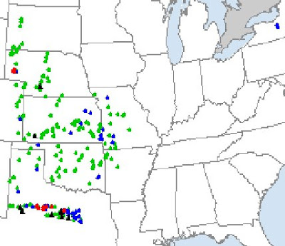
There were 10 tornado reports shown by the Storm Prediction Center yesterday.
I had a chance to watch some amazing streaming video yesterday by some storm chasers in Texas, including Dave Drummond, who caught a cone-shapped tornado on his live stream.
My friend James Payton relayed an interesting chase account and photos from his friend Cary Allen at KCBD-TV 11 in Lubbock, TX.
It was an awesome day. Low 53 / High 84 Today's weather theme song should be "Mr Blue Sky" by ELO, "Hey there mister blue, We're so pleased to be with you, Look around see what you do, Ev'rybody smiles at you"Have a great evening everyone!
Nathan in northen Wisconsin has an excellent weather blog and he has been running a very cool series of posts entitled, "The Death of Frosty". Go check it out!
"A passenger plane landed safely at BWI Marshall Airport after being struck by lightning yesterday morning, according to an airport spokesman.
The Continental Express plane was struck about 10:30 a.m., said airport spokesman Jonathan Dean. No one was injured, and the plane landed without incident, Dean said."
As expected, there were not many problems with severe weather in Alabama and what did occur was in the southwest part of the state. The only report I could find was that two pine trees were snapped along US Highway 45 south of Fruitdale in Washington County at around 8:15 p.m.
There were three tornadoes reported in South Mississippi, in Copiah, Hinds, and Winston counties. There was an injury reported near Louisville in Winston County.
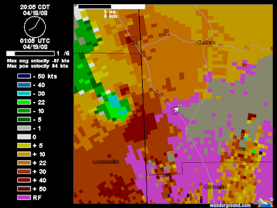
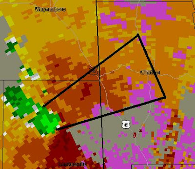
AT 809 PM CDT…TRAINED WEATHER SPOTTERS REPORTED A ROTATING WALL CLOUD WITH THIS STORM IN GREENE COUNTY MISSISSIPPI. THIS POSSIBLE TORNADO WAS LOCATED NEAR FRUITDALE…OR ABOUT 14 MILES SOUTHWEST OF CHATOM…MOVING EAST AT 30 MPH.
BULLETIN - EAS ACTIVATION REQUESTED
TORNADO WARNING
NATIONAL WEATHER SERVICE MOBILE AL
755 PM CDT FRI APR 18 2008

THE NATIONAL WEATHER SERVICE IN MOBILE HAS ISSUED A

* TORNADO WARNING FOR...
 CENTRAL WASHINGTON COUNTY IN SOUTHWEST ALABAMA...
 THIS INCLUDES THE CITY OF CHATOM...

* UNTIL 845 PM CDT

* AT 752 PM CDT...NATIONAL WEATHER SERVICE METEOROLOGIST DETECTED A
 SEVERE THUNDERSTORM CAPABLE OF PRODUCING A TORNADO 11 MILES WEST OF
 FRUITDALE...OR ABOUT 11 MILES NORTH OF LEAKESVILLE...MOVING EAST AT
 30 MPH. THIS STORM IS ALSO CAPABLE OF PRODUCING GOLF BALL SIZE
 HAIL AND DESTRUCTIVE WINDS IN EXCESS OF 70 MPH.

* THE TORNADO WILL BE NEAR...
 FRUITDALE AND YELLOW PINE BY 810 PM CDT...
 ESCATAWPA BY 815 PM CDT...
 TIBBIE AND 6 MILES SOUTH OF CHATOM BY 830 PM CDT...
 SEABOARD BY 835 PM CDT...
 HAWTHORN...SUNFLOWER AND 6 MILES SOUTHWEST OF WAGARVILLE BY 845 PM
 CDT...
This storm is showing pretty good signs of rotation and will soon be knocking on the door of Washington County, AL
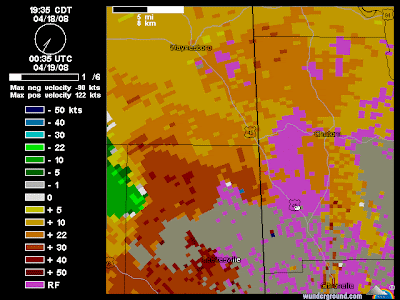
BULLETIN - EAS ACTIVATION REQUESTED
TORNADO WARNING
NATIONAL WEATHER SERVICE MOBILE AL
736 PM CDT FRI APR 18 2008

THE NATIONAL WEATHER SERVICE IN MOBILE HAS ISSUED A

* TORNADO WARNING FOR...
 NORTHERN GREENE COUNTY IN SOUTHEAST MISSISSIPPI...

* UNTIL 815 PM CDT

* AT 730 PM CDT...NATIONAL WEATHER SERVICE METEOROLOGISTS DETECTED A
 SEVERE THUNDERSTORM CAPABLE OF PRODUCING A TORNADO NEAR AVERA...OR
 ABOUT 15 MILES NORTHWEST OF LEAKESVILLE...MOVING EAST AT 30 MPH.

* THE TORNADO WILL BE NEAR...
 RURAL CENTRAL GREENE COUNTY AT 750 PM CDT
 RURAL NORTHEASTERN GREENE COUNTY AT 800 PM CDT
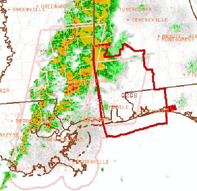
Tornado Watch - SW Alabama
TORNADO WATCH NUMBER 208
NWS STORM PREDICTION CENTER NORMAN OK
640 PM CDT FRI APR 18 2008

THE NWS STORM PREDICTION CENTER HAS ISSUED A
TORNADO WATCH FOR PORTIONS OF

SOUTHWEST ALABAMA
FAR WESTERN PARTS OF THE FLORIDA PANHANDLE
COASTAL WATERS

EFFECTIVE THIS FRIDAY NIGHT FROM 640 PM UNTIL MIDNIGHT
CDT.

TORNADOES...HAIL TO 1 INCH IN DIAMETER...THUNDERSTORM
WIND GUSTS TO 70 MPH...AND DANGEROUS LIGHTNING ARE
POSSIBLE IN THESE AREAS.

THE TORNADO WATCH AREA IS APPROXIMATELY ALONG AND 50
STATUTE MILES EAST AND WEST OF A LINE FROM 45 MILES
NORTHWEST OF EVERGREEN ALABAMA TO 35 MILES SOUTH OF
MOBILE ALABAMA.  FOR ACOMPLETE DEPICTION OF THE WATCH
SEE THE ASSOCIATED WATCH OUTLINE
UPDATE (WOUS64 KWNS WOU8).


REMEMBER...A TORNADO WATCH MEANS CONDITIONS ARE
FAVORABLE FOR TORNADOES AND SEVERE THUNDERSTORMS IN
AND CLOSE TO THE WATCH AREA. PERSONS IN THESE AREAS
SHOULD BE ON THE LOOKOUT FOR THREATENING WEATHER
CONDITIONS AND LISTEN FOR LATER STATEMENTS
AND POSSIBLE WARNINGS.

OTHER WATCH INFORMATION...CONTINUE...WW 207...

DISCUSSION...SCTD SEMI-DISCRETE SUPERCELLS MAY
CONTINUE TO FORM AHEAD OF SRN MS/SE LA COLD FRONT
THROUGH THIS EVENING AS THE FRONT CONTINUES E INTO
AL.  TEMPORAL VEERING OF FLOW WILL OCCUR AT ALL
LEVELS OVER SW AL AS NEGATIVELY-TILTED LWR MS VLY
UPR TROUGH CONTINUES NEWD.  THIS SHOULD SUPPORT
INCREASED LOW-LEVEL MOISTURE ADVECTION INTO WW
AREA AT THE SAME TIME THAT DEEP DIRECTIONAL SHEAR
STRENGTHENS.  OVERALL RESULT MAY BE AN EXTENTION
OF CURRENT SVR/ISOLD TORNADO THREAT IN SE MS/SE
LA EWD INTO SW AL...BEFORE DIURNAL COOLING/NVA
ULTIMATELY SUPPRESS STORM DEVELOPMENT LATER TONIGHT.
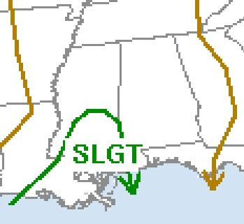
The Storm Prediction Center (SPC) maintains a "slight risk" for severe storms later today and tonight over SE Louisiana and South Mississippi. The reason, I think, that the area outlooked for severe weather is so small is that CAPE (convective available potential energy) values are predicted by the models to be rather low, as shown in the GFS output shown below for 1 a.m. Saturday.
One thing I have learned, though, is that significant tornadoes can and sometimes do occur in relatively low CAPE environments if helicity (the amount of wind shear in the lower atmosphere) is great enough. Healthy shear values are predicted by the models to exist across Alabama at 10 p.m. tonight according to the RUC model. This is shown in the map below. This is especially the case in the southwest part of Alabama.
I am not expecting a major severe weather outbreak, but this one definitely bears watching. This is especially true because last Friday models seemed to underestimate the amount of instability and the fact that the calendar shows we are still in mid-April. The fact that this is a night time event may help to limit stability as well.
Regardless, I still think it is a good time to be ready for any severe weather that may pop up. As J.B. Elliott and James Spann often point out, with severe weather, "expect the unexpected".
Please be weather aware tonight between 6 p.m. and 6 a.m. Saturday!
--------------Edited to add:---------------------
HAZARDOUS WEATHER OUTLOOK NATIONAL WEATHER SERVICE HUNTSVILLE AL 107 PM CDT FRI APR 18 2008
THIS HAZARDOUS WEATHER OUTLOOK IS FOR NORTH ALABAMA AND PORTIONS OF SOUTHERN MIDDLE TENNESSEE.
.DAY ONE...TONIGHT...
SHOWER AND THUNDERSTORM ACTIVITY IS EXPECTED INTO THIS EVENING ACROSS THE TENNESSEE VALLEY AS A COLD FRONT PASSES THROUGH THE AREA. INITIAL CONVECTION WILL BEGIN TO AFFECT NORTHWEST ALABAMA LATE THIS AFTERNOON...AND WILL CONTINUE TO MOVE EASTWARD THROUGH TONIGHT. THE SECOND ROUND OF CONVECTION IS EXPECTED ALONG THE FRONT LATER TONIGHT AS IT MOVES ACROSS THE AREA. THE GREATEST THREAT WITH ANY OF THE STRONGER STORMS THAT DEVELOP WILL BE GUSTY WINDS. SEVERE WEATHER IS NOT EXPECTED DURING THIS TIME.
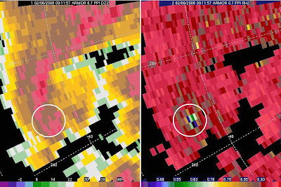
Above ARMOR radar image from UAH of the 2/6/08 Lawrence County, AL tornado signature
Michelle Miklik shared this interesting article about some potentially valuable research underway at UAH.
Unexpected image from killer tornado might lead to precise storm warnings
"An unexpected radar image of air-borne debris from the Feb. 6 tornado that killed four people in Lawrence County, Ala., might help scientists develop better tools for warning the public when and where strong tornadoes are on the ground. Scientists in the Earth System Science Center at The University of Alabama in Huntsville (UAH) are studying radar data from the early morning tornado to see if the radar signature from the debris is so distinctive that computers can be programmed to instantly recognize it, so more timely and precise warnings might be issued."
Today's wx theme song: "Blue Clear Sky" by George Strait. "Surprise your new love has arrived Out of theblue clear sky."Oh, and here's a video to go with the theme song of the day. By the way, apparently there is nothing on YouTube with George Strait himself, so check this out as a fun alternative!
Have a great day under the Blue Clear Sky everyone!
A beautiful start to a great day!
A huge thank you to fellow ABC 33/40 Skywatcher Michelle Miklik for sharing these great photos with me! She took these pictures this morning along Highway 431 around Alexandria, Alabama. Alexandria is located between Anniston and Gadsden on Highway 431, just northeast of Fort McClellan. I'll never forget taking a 25+ mile hike at Fort McClellan as a Boy Scout many years ago. Please don't ask how many years ago! : )
Shelby county wall cloud video...
Thanks so much to fellow ABC 33/40 Skywatcher Stephen Pridmore for sharing this video that he took of a wall cloud in Helena, AL in Shelby County last Friday afternoon!
Check out this video: Questionable Wall
Happy Birthday, Mr. Elliott
Alabama Weather Legend J.B. Elliott celebrates the 46th anniversary of his 30th birthday today!
This is my sincere wish for a happy birthday to the longtime NWS meteorologist, encourager of weather geeks, voice of NOAA Weather radio, Alabamawx.com weather blog author, forecaster, brown sugar cinnamon pop tart eater and doughnut connoisseur, legendary coffee drinker, and best friend of Miss Molly!
A weather-related song quote for today...."I wanted to be with you alone and talk about the weather..." Anyone here remember "Head over heels" by Tears for Fears in the mid-80's? Ah, the awesome college memories!
There were numerous reports of ice falling from the sky today in North and Central Alabama. There is considerable debate as to whether it was sleet, hail, graupel, or all three.
My friend Mike at work said there was ice on his windshield this morning before he left for work. My theory is that was sleet. I think the precipitation began as sleet. Alabama weather legend J.B. Elliott said just before 2 p.m. that, "There are now numerous very small convective showers. These are producing brief but quick periods of sleet. We have had numerous reports of that across North and Central Alabama....So some of the precipitation can be brief small hail due to the convective nature of the showers. The technical name for that is “grauple” which means small soft hail. It is usually quite small. That term (grauple) has been around forever but rarely used in weather information."
Temperatures will fall quickly tonight under clear skies and will drop to the freezing mark or a little below. In some areas, especially in the northwest corner of the state and in the higher elevations, sub-freezing temperatures may hold on for as long as 6-hours early tomorow. That has prompted the National Weather Service to issue a Freeze Warning from midnight tonight until 9 a.m. Tuesday.
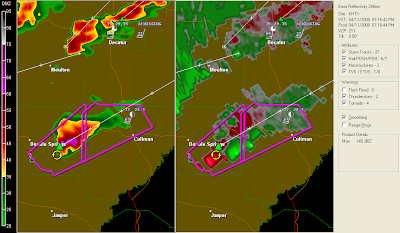
Thanks to Nathan for sending me the above radar captures from Friday's storm. Also thanks to Rick Lipscomb for his radar support as I followed the storms.
Storm surveys are underway by the Huntsville and Birmingham NWS Offices.
Friday April 11 thankfully looked more scary than it turned out to be. There were numerous reports of wall clouds, funnel clouds, and NEXRAD radar images of hooks and rotation. Thankfully, all of this resulted in no known injuries in Alabama, and very scattered damage reports. I suppose that made it an ideal day to chase storms, if there is such a thing in Alabama.
Friday was a textbook case as to why chasing is so difficult in the South. These were better conditions than normal to spot storms, but it was still difficult at times. After eating lunch with the unit I supervise at work, I checked back on the weather situation. Much of Alabama had been placed under a tornado watch and James Spann was streaming live on ABC3340.com for a tornado warning in Marion County.
Storms were popping up rapidly, more than forecast by the meteorologists and models. I was most concerned about the storm near Glen Allen in Marion County, Alabama. I looked at the radar and determined that it was about an hour away from western Cullman County, where my boys attend school. I was dismayed to learn that the schools in Cullman County were releasing students at 1 p.m. By my calculation, that was very close to the time when the mesocyclone in Marion County would be in the area where my boys' school is located.
I called my ex-wife who was in complete agreement with me. She began high-tailing it to the west out of Cullman. Our goal was to get our kids out of harm's way before the storm hit. She wasn't sure she would make it. She did, and I was thankful. As she and I were talking, I heard reports of damage out of Winston County from fellow storm chaser, Brett Adair, who was streaming live video back to James Spann at ABC 33/40. My concern now was for the students in Cullman County who would be in buses as a mesocyclone with a possible tornado was headed their way.
While all this was going on I was updating co-workers on the weather situation and letting them know that I was thinking about leaving at 1:00. I emailed my boss, who, after asking me if I was storm chasing and showing concern for my children, graciously allowed me to take leave. I was relieved to learn that my ex wife had gotten our children to shelter ahead of the storm. Credit is due her for driving them to three separate shelters as they dodged three tornado-warned mesocyclones Friday afternoon.
I decided to head south to either I-65 Exit 308 (Hwy 278) or a little further north and closer to the storm at Exit 310 (Hwy 157). Out of caution I first headed to Exit 308 and began communicating with James Spann via his Skywatcher IM conference. It soon became evident by listening to Spann and Jason Simpson on FM 97.3, as well as looking at the sky and the radar on my laptop, that it would be safe to drive two miles further north to exit 310.
From this point I began photographing and taking video of a very impressive wall cloud and beaver tail inflow cloud northwest of Cullman. This storm was clearly rotating and occasionally producing cloud to ground lightning. It was amazing to behold. I followed it to the northeast. I remained to the southeast of the storm as I drove northeast through Cullman County on highway 157 and then highway 69.
I entered Marshall County at Arab and continued all the way to Guntersville Lake. I stopped there and took video and photos of the storm as it passed about 6-10 miles northwest to northeast of my location. I learned today that the storm produced two small EF0 tornadoes while I observed it 6-10 miles away. Although I could clearly see the rotation, the wall cloud and tornado were wrapped in rain. I did see an increase in cloud to ground lightning output that probably coincided with the tornado touchdowns.
I was careful as I drove, but I must admit I spent a lot of time glancing out of my side window or out of the left side of my windshield to my northwest. As I drove through Cullman, Fairview, Baileyton, Joppa, Arab, and on to Guntersville Lake, I saw a wall cloud the whole way. The only point it seemed to weaken turned out to probably be an illusion. In northeastern Cullman County, the storm was a bit further away than the rest of the route. The wall cloud was there and at times it seemed quite large. It makes me wonder if there would have been a large wedge tornado if there had been just a bit more directional shear near the surface. Thankfully, that did not happen.
I drove south out of Marshall County through the eastern side of Blount County before returning home to pick up my kids. I saw some very heavy rain and some minor flooding, but no more signs of major rotating storms. I stopped at a country gas station near Blountsville that was being run by a mother and her adult daughter. They were gracious enough to allow me to charge the battery on my laptop. The daughter told me she was a single mother of a nine year old boy who was scared of storms. My suggestion to her was to educate him as much as possible. She wanted to know how to get James Spann to speak at her son's school. I suggested that she ask his teacher to email Mr. Spann. She was financially very poor so I suggested that she take her son to the library and that they read everything they can about weather and storms.
What a day! I won't forget it soon.
That was a tornado-producing meso in Marshall County...
PUBLIC INFORMATION STATEMENT
NATIONAL WEATHER SERVICE HUNTSVILLE AL
935 AM CDT MON APR 14 2008
..STORM SURVEY IN MARSHALL COUNTY COMPLETED
THE NATIONAL WEATHER SERVICE IN HUNTSVILLE…WORKING WITH OFFICIALS FROM MARSHALL COUNTY EMA…COMPLETED STORM SURVEYS OF THE DAMAGE IN MARSHALL COUNTY FROM A SEVERE THUNDERSTORM ON FRIDAY…APRIL 11.
THE SURVEYS CONCENTRATED ON TWO LOCATIONS…ALONG BALL PARK ROAD NEAR THE TOWN OF UNION GROVE…AND RURAL AREAS SOUTHEAST OF GRANT.
NEAR UNION GROVE…SEVERAL TREES WERE UPROOTED…ONE SHED WAS DESTROYED…AND ONE RESIDENCE SUSTAINED MODERATE DAMAGE TO THE BACK OF THE HOME. DAMAGE CONSISTENT WITH A TORNADO WAS FOUND. THIS TORNADO WAS RATED AS AN EF-0… WITH MAXIMUM WINDS OF 85 MPH. THE TORNADO DAMAGE EXTENDED FOR APPROXIMATELY 1.5 MILES…WITH A MAXIMUM
WIDTH OF 100 FEET.
NEAR GRANT…SEVERAL TREES WERE UPROOTED…SEVERAL BARN STRUCTURES LOST ROOFING MATERIAL…AND SOME HOMES SUSTAINED MINOR ROOF DAMAGE. THIS DAMAGE WAS CONSISTENT WITH A TORNADO…RATED AS AN EF-0…WITH MAXIMUM WINDS OF 75 MPH. THE TORNADO DAMAGE EXTENDED FOR APPROXIMATELY
1.2 MILES…WITH A MAXIMUM WIDTH OF 300 FEET.
---
The Union Grove EF-0 tornado was 6 miles to my northwest and Grant was 10 miles to my northeast as I took video and photos of the mesocyclone. There is no way under heaven that I could have reported a tornado, though. The wall cloud was obscured by rain. Here are some photos I took of that parent thunderstorm.
The Storm Prediction Center has issued a Tornado Watch until 4 p.m. for parts of Louisiana, Mississippi, Alabama, and Tennessee. The probabilities for this watch,according to the SPC are:
URGENT - IMMEDIATE BROADCAST REQUESTEDTORNADO WATCH NUMBER 195 NWS STORM PREDICTION CENTER NORMAN OK 1015 AM CDT FRI APR 11 2008
THE NWS STORM PREDICTION CENTER HAS ISSUED A TORNADO WATCH FOR PORTIONS OF
WESTERN AND NORTHERN ALABAMA NORTHEASTERN LOUISIANA CENTRAL AND NORTHEASTERN MISSISSIPPI MIDDLE AND EASTERN TENNESSEE
EFFECTIVE THIS FRIDAY MORNING AND AFTERNOON FROM 1015 AM UNTIL 400 PM CDT.
TORNADOES...HAIL TO 1.5 INCHES IN DIAMETER...THUNDERSTORM WIND GUSTS TO 70 MPH...AND DANGEROUS LIGHTNING ARE POSSIBLE IN THESE AREAS.
THE TORNADO WATCH AREA IS APPROXIMATELY ALONG AND 100 STATUTE MILES EAST AND WEST OF A LINE FROM 55 MILES NORTHWEST OF CROSSVILLE TENNESSEE TO 45 MILES WEST OF PINE BELT MISSISSIPPI. FOR A COMPLETE DEPICTION OF THE WATCH SEE THE ASSOCIATED WATCH OUTLINE UPDATE (WOUS64 KWNS WOU5).
REMEMBER...A TORNADO WATCH MEANS CONDITIONS ARE FAVORABLE FOR TORNADOES AND SEVERE THUNDERSTORMS IN AND CLOSE TO THE WATCH AREA. PERSONS IN THESE AREAS SHOULD BE ON THE LOOKOUT FOR THREATENING WEATHER CONDITIONS AND LISTEN FOR LATER STATEMENTS AND POSSIBLE WARNINGS.
DISCUSSION...AREA IS EXPERIENCING DIABATIC DESTABILIZATION AT SFC AND WEAKENING MLCINH...ALONG WITH SUFFICIENT MOISTURE TO SUPPORT CONTINUING TSTM INTENSIFICATION ACROSS WW AREA -- BOTH ALONG AND AHEAD OF PRIMARY CONVECTIVE BAND INITIALLY OBSERVED FROM WRN TN SWWD TO NERN LA. FAVORABLE LOW-LEVEL HODOGRAPHS AND DEEP-LAYER SHEAR PROFILES EXIST TO SUPPORT BOTH SUPERCELLULAR AND BOW/QLCS STORM MORPHOLOGIES...WITH RELATIVELY DISCRETE STORMS POSSIBLE AHEAD OF MAIN LINE.
AVIATION...TORNADOES AND A FEW SEVERE THUNDERSTORMS WITH HAIL SURFACE AND ALOFT TO 1.5 INCHES. EXTREME TURBULENCE AND SURFACE WIND GUSTS TO 60 KNOTS. A FEW CUMULONIMBI WITH MAXIMUM TOPS TO 450. MEAN STORM MOTION VECTOR 24035.
In honor of Dewdrop's very observant comment, I am editing this post's title and including the following quotes:
"Red sky at night, sailor's delight. Red sky in morning, sailor’s warning."
“Evening red and morning gray; two sure signs of one fine day.”
“Evening red and weather fine. Morning red, of rain’s a sign.”
“An evening gray and a morning red will send the shepherd wet to bed.”
“Like a red morn that ever yet betokened, Wreck to the seaman, tempest to the field, Sorrow to the shepherds, woe unto the birds, Gusts and foul flaws to herdmen and to herds.” - Billy
Shakespeare
“When in evening, ye say, it will be fair weather: For the sky is red. And in the morning, it will be foul weather today; for the sky is red and lowering.” Jesus - Matthew 16: 2-3
A red sky occurs when the atmosphere has many dust and moisture particles. Red wavelengths are breaking through the atmosphere, but we do not see the blue end of the spectrum well because those colors are scattered and broken up. A red sky in the morning usually indicates that there is a high water content in the atmosphere. So, rain may be on its way.
I have been posting about Alabama weather on this blog since April 2006. Here you will find my observations, information provided by the NWS, links to quality weather information from other sources, and historical weather data. Please "follow" me on Twitter and join my "fan" page on Facebook. Twitter and Facebook posts are usually more current/breaking news. I appreciate your visit. Enjoy and come back soon. Thank you!
Follow @bamawx
Bamawx.com - Mike Wilhelm's Alabama Weather Blog on Facebook
Bamawx.com - Mike Wilhelm's Alabama Weather Blog on Facebook
Frosty Morning and an Extraordinary Land Breeze - Much of the state experienced a hard freeze last night, a combination of unusually cold air and clear skies, which allowed the earth to radiate heat to spa...
8 hours ago
Jon Davies Severe Weather Notes
March 25, 2021 deadly tornado outbreak in Alabama and Georgia - One week ago today, a deadly tornado outbreak in Alabama (AL) and Georgia (GA) caused 6 deaths and a number of injuries, making it the deadliest tornado ...
1 week ago
The Flight of a South Georgia Storm Chaser
That's why everybody advises me this - That's exactly what I wanted! http://link.denaliatving.com Jennifer
2 years ago
MWN Blog
June 2017 Climate Data for Memphis, TN - June Climate RecapFor the first time in recent memory, Memphis International Airport experienced consecutive months of below average temperatures in May an...
3 years ago
Dr. Jeff Masters' WunderBlog
Meteorology of Saturday's Colombian Flood Disaster That Killed 254 - At least 254 people were killed in the in the city of Mocoa (population 40,000) in southwest Colombia near the border of Ecuador early Saturday, when torre...
4 years ago
The Weather Guy
- Since 2014 the Cookeville Weather Guy has taken a hiatus from posting. At some point in the very near future he will resume. For now you can access his Fac...
4 years ago
Severe Plains
Thanksgiving Cleanup - Mild temperatures and an ambitious brother-in-law meant the opportunity to continue the cleanup of Cedar trees in the rear of the property. With loppers, h...
4 years ago
Tennessee Valley Weather
- I'm very sorry, but this blog has finally kicked the bucket. An informal weather blog will be kept at www.thatweatherblog.blogspot.com, as I have the time,...
6 years ago
EYE OF THE STORM
So... You want to chase a tropical cyclone? - ANYONE that wants to chase a hurricane/typhoon/cyclone should watch this. This is as real as it gets! Thankfully Jim made it through Super Typhoon Haiy...
7 years ago
Iowa WX
Grinnell F3 Tornado of 1978 - This may not be the season for tornadoes and we’ve seen in the past that tornadoes can occur at any time no matter what the calendar says. One such occurre...
7 years ago
WeatherScout
Agilent Indonesia 35670A FFT Dynamic Signal Analyzer - Agilent Indonesia 35670A 2 or 4 channel FFT Dynamic Signal Analyzer, DC-102.4 kHz Description The Agilent 35670A is a versatile FFT analyzer with built in ...
7 years ago
Prairiestorm Media Blog
sky drama - Haven't released anything officially, but for the sake of updating... if you're coming here looking for recent posts, STOP. Sky Drama is coming.
8 years ago
Storm Chasing Mikey
Hurricane Sandy - Hurricane Sandy Intensifies Over Jamaica Hurricane Sandy did not disappoint and has indeed become the Historic Storm we started watching on long range fore...
8 years ago
SOUTHERN WEATHER BRIGADE
Virginia Lightning - On Wednesday May 23rd, we had a very isolated cell with a strong hail core move up from North Carolina into Southeastern Virginia around 10:30pm est. I lo...
8 years ago
Justyn Jackson's Weather Blog
Dual-Pol Applications - Dual-pol installations are now being pushed in full force across the country. As of this post, eight radars are equipped with dual-pol, including the proto...
9 years ago
Southwest Georgia Stormtrack
A reminder......... - I work hard and go to considerable expense to capture my work. So please consider this before stealing any of my work. If you do, I will find you and the ...
9 years ago
High Plains Drifter
test image - this is only a test
9 years ago
Alaska Weather Blog
Tuesday March 8, 2011 - Things are really warming up right now! I know that sounds funny, especially since temps are still below freezing, however with the additional daylight (10...
10 years ago
Dan's Wild Wild Weather Journal
Did The Press Miss the Boat on The Black Hole Story?? - This page will soon no longer be updated- go to the new home at THE AGU BLOGOSPHERE You likely heard about it a few days ago. NASA announced the detection ...
10 years ago
Iowa Chaser
NEW BLOG -- Update Link - The Iowa Chaser blog is now the Severe Plains blog! All of the previous posts have been moved, and additional posts since December have been added to the n...
11 years ago
The Long Distance Chase Team...
Best of Hurricane Video!!! - Sorry it took me so long, but I finally put up the Best of Hurricane Video on youtube... It's from Hurricanes Ike, Rita, and Katrina... Honestly words can...
11 years ago
Nikki-Dee’s
*Your Baghdad Weather Glance* -
11 years ago
Tommy Self's North Alabama Weather Blog
Vortex 2 - Well it has been kinda dull weather wise around here the last few days so I turn my attention to the plains and the great tornado hunt.Looks like they ...
11 years ago
WSFA 12 Weather Blog
-
NSSTC Collaborative Weather Blog
-
Green Screen Weather
-
Severe Storm & Hurricane Video & Pictures, Florida Weather, Stock Footage, Storm Chaser Jeff Gammons - Weatherzine.Net


 tornado warning in Marion County.
 west out of Cullman. Our goal was to get our kids out of harm's way before the storm hit. She wasn't sure she would make it. She did, and I was thankful. As she and I were talking, I heard reports of damage out of Winston County from fellow storm chaser, Brett Adair, who was streaming live video back to James Spann at ABC 33/40. My concern now was for the students in Cullman County who would be in buses as a mesocyclone with a possible tornado was headed their way.
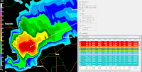 know that I was thinking about leaving at 1:00. I emailed my boss, who, after asking me if I was storm chasing and showing concern for my children, graciously allowed me to take leave. I was relieved to learn that my ex wife had gotten our children to shelter ahead of the storm. Credit is due her for driving them to three separate shelters as they dodged three tornado-warned mesocyclones Friday afternoon.
 listening to Spann and Jason Simpson on FM 97.3, as well as looking at the sky and the radar on my laptop, that it would be safe to drive two miles further north to exit 310.
 I entered Marshall County at Arab and continued all the way to Guntersville Lake. I stopped there and took video and photos of the storm as it passed about 6-10 miles northwest to northeast of my location. I learned today that the storm produced two small EF0 tornadoes while I observed it 6-10 miles away. Although I could clearly see the rotation, the wall cloud and tornado were wrapped in rain. I did see an increase in cloud to ground lightning output that probably coincided with the tornado touchdowns.
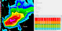 weaken turned out to probably be an illusion. In northeastern Cullman County, the storm was a bit further away than the rest of the route. The wall cloud was there and at times it seemed quite large. It makes me wonder if there would have been a large wedge tornado if there had been just a bit more directional shear near the surface. Thankfully, that did not happen.
 being run by a mother and her adult daughter. They were gracious enough to allow me to charge the battery on my laptop. The daughter told me she was a single mother of a nine year old boy who was scared of storms. My suggestion to her was to educate him as much as possible. She wanted to know how to get James Spann to speak at her son's school. I suggested that she ask his teacher to email Mr. Spann. She was financially very poor so I suggested that she take her son to the library and that they read everything they can about weather and storms.


