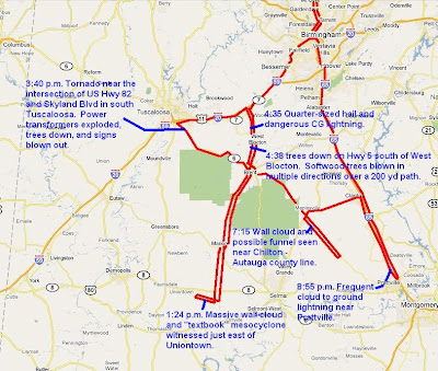
Chase Map
INTRODUCTION
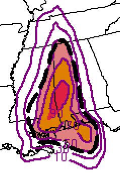
Friday April 15, 2011 will go down as one of the most productive and intense Alabama storm chases that I have experienced. As of 4/21/11, 23 tornadoes have been confirmed by the NWS Birmingham and 11 have been confirmed by the NWS Mobile for a total of 34 in the State of Alabama. There may be a few more confirmed when surveys are completed. The highlights of the trip included seeing a very photogenic "textbook" mesocylone with a wall cloud east of Uniontown, Alabama, witnessing and reporting a rain-wrapped tornado in southern Tuscaloosa, quarter-sized hail and trees down in Bibb County, and witnessing a wall cloud and possible funnel at dusk on the Chilton-Autauga County line.
PLANNING AND PREPARATION
SPC SREF Significant Tornado Parameter 36 hours
This event first appeared to be potentially significant with the model runs from Tuesday night/Wednesday morning. I listen to James Spann’s Weather Xtreme video regularly, usually while I get ready for work in the morning or sometimes I pick it up on my phone. He does a very good job describing the model output. In addition, I looked at all of the model output for the usual severe weather parameters (instability, shear, composite indices, etc.) numerous times Wednesday and Thursday. I like to use Earl Barker’s model page, the College of Dupage model page, and the SREF data from the Storm prediction center site. Everything seemed to be in place for a major severe weather event. The only ingredient that seemed questionable was instability. The models were pretty consistent. However, the area of highest instability seemed to stay roughly south of Interstate 20 and it seemed to be maximized over the Alabama-Mississippi state line.
With all of the parameters seemingly coming together, Wednesday I asked for and was approved to take leave on Friday. I did later get a scare when some circumstances changed and I almost did not get to be off work. Through some help from a co-worker, the good graces of my boss, and a little prayer, I was finally able to obtain approval to be on leave.
Thursday night my partner, John Brown and I had a phone briefing around 9:30. We decided meet in Birmingham and head west, perhaps to Meridian , Mississippi to set up. I met John late Friday morning and our initial decision was to drive to Tuscaloosa and then decide whether we wanted to go west or south from thereDALLAS MESOCYCLONE


Dallas/Perry County Mesocyclone Time Lapse

While heading west out of Birmingham we decided to turn south at the West Blocton (Alabama Highway 5) exit and attempt to intercept some cells that were moving out of Mississippi. We decided that we had plenty of time to get in a safe position to intercept one or two of those cells. We took Highway 5 all the way down to the US 80 corridor, west of Selma . That was a great choice for several reasons. First, the land was flat and there weren’t many trees, which is a rare viewing opportunity in Alabama . In addition we were able to watch a textbook mesocyclone produce a wall cloud. The video and pictures from that particular storm may be of use for future storm spotting training purposes. While we did not see a tornado with that storm, the structure itself made that a good decision. Around that time, tornadoes were being reported in Mississippi by Greg Nordstrom’s Mississippi State chase team and others. We would have liked to have gone west and intercepted those cells, but we would have had to have left earlier. We were also a bit concerned about committing too far west and missing anything in Alabama .
TUSCALOOSA TORNADO

Tuscaloosa Tornado Video by John Brown
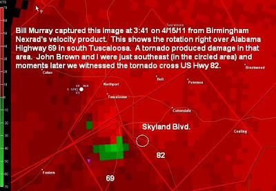
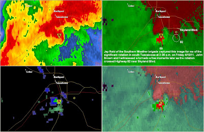
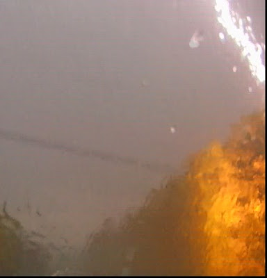
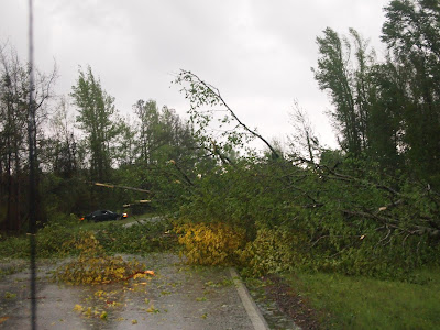
Next we decided to go north. John debated about west at Marion , towards Greensboro . I was concerned that we didn’t have enough time to get in position to see that storm safely. We decided to go north toward Centreville, and then northwest towards Tuscaloosa . We knew we had plenty of time to intercept a cell that had a history of tornado reports and damage reports. We stopped for a long time in Duncanville , southeast of Tuscaloosa . For a while it looked as if the tornadic circulation was headed directly at us but then it appeared to be make a bit of a turn to the left, or north of our location. We finally decided to go north, slowly, on US 82, as we were hearing reports of a tornado to our west on Alabama Highway 69. As we drove in to southern Tuscaloosa, we saw transformers exploding within approximately a half-mile, to our north and some obvious indications of a rain-wrapped tornado directly in front of us. I reported that tornado on the ABC 33/40 Skywatcher instant message chat and Meteorologist Jason Simpson immediately used that report on the air. In fact, we were on the outer circulation of the tornadic rotation. At one point we stopped, as the winds suddenly increased. We were concerned that the tornado may have been growing and “back-building” toward us. We stayed in a safe position, relative to the storm, but as we drove north we saw tree debris along US 82, just south of Skyland Boulevard. As we turned right (east) on Skyland, we saw where the tornado crossed, blowing out some signs and more tree debris. This storm took a northeast path from there and we were no longer able to keep up with it.
BIBB COUNTY LIGHTNING, HAIL, AND TORNADO DAMAGE

Next we decided to go back toward West Blocton and possibly intercept a cell that was taking aim on the area just south of West Blocton. That storm was producing a reported tornado near Demopolis. As we traveled down Alabama 5, south of West Blocton, we were too late to witness the tornado. However we did experience quarter-sized hail, witnessed a 200-300 yard path with trees and power lines down, and had a lightning bolt explode a tree within feet of John’s truck as we were traveling down the highway. I reported the trees down and that report was immediately relayed my meteorologist Jason Simpson at ABC 33/40. While we were there, we met storm chaser Brett Adair who showed me video of a tornado he captured earlier in the afternoon.
CHILTON-AUTAUGA WALL/FUNNEL

From there we drove south and intercepted a storm near the Chilton-Autauga county line on US Highway 82 just after sunset. We found only one small area with any viewing potential. Everything else was obscured by trees and hills. We found a spot on a ridge with a view to the northwest. John and I saw a wall cloud and a possible funnel. This storm had previously produced a report of a tornado. ABC 33/40 meteorologists James Spann and Jason Simpson used John’s live stream in their coverage of this warning. This was going to be our last storm of the day, but then we decided to drive to Prattville to get in position for another tornado-warned supercell.
PRATTVILLE TORNADO WARNING/CG LIGHTNING
We took Highway 22 from Maplesville over to Clanton and then we turned south on I-65. This storm was producing an amazing amount of lightning to the west. By the time it got to our location, we were not able see any indication of a wall cloud, funnel, or tornado. I am still looking at footage to determine if we may have captured some good lightning images.
THE RIDE HOME
After that, it was a long drive back to Birmingham and then Huntsville . John and I were a bit giddy by this point and we laughed as we listened to ourselves react to the close lightning strike. I listened to my footage all the way from Birmingham to Huntsville . After I arrived home, John texted me the bad news that fatalities were reported in Autauga County , in a tornado that moved through there after we left. I stayed up until after 3 a.m. editing footage.
That was definitely an adventure to remember.
...
ABC 33/40 Coverage...


