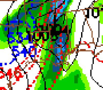
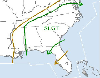
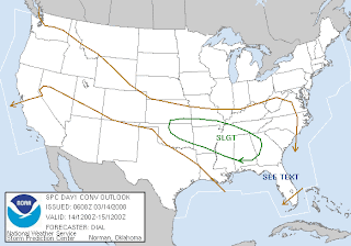
The above image is the outlook for Monday March 3 from the Storm Prediction Center. This is the outlook that they issued early this morning.

This is the probability map associated with the above outlook. The greatest risk of severe weather in Alabama, according to the SPC, is in West Alabama, generally along and west of Interstate 65.

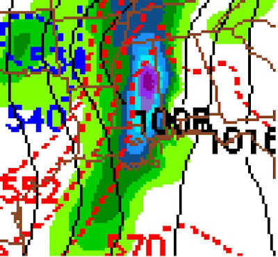
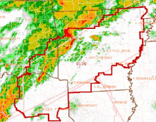
This is the latest from the GFS model that was issued at midnight last night. The 12z (or 6 a.m. CT update should be available soon).
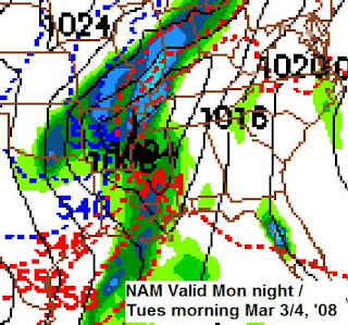
The above is the most recent NAM output, issued at 12z (6 a.m.) today. As you can see, the NAM projects that this storm will be progressing slower and will arrive later than the GFS.
It now appears that we might be looking at another nighttime severe weather threat on Monday night. The projections for the wind field with this storm system are very impressive. The biggest question is whether instability will be enough to cause supercells to develop ahead of the main squall line. If they do, wind shear will be sufficient to cause the storms to rotate and produce tornadoes.
The timing of this event, if it moves in overnight, might serve to inhibit instability.
What to look for:
1. Dewpoints on Monday - If we see dewpoints above 60, there may be enough instability for a few tornadoes. If dewpoints make it to near 65, this may be a major tornado outbreak.
2. Sunshine on Monday - The more daytime heating we receive Monday, the more likely our dewpoints will be high enough to create the instability needed for convection ahead of the main line. Cloudiness on Monday would limit dewpoints, instability, and the threat for tornadoes.
3. Air temperature aloft. Part of the instability question has to do with temperatures aloft. Dewpoints will not have to be as high at the surface if the air aloft is cold enough. On the otherhand, if there is enough modified, warmer air aloft, dewpoints will have to be higher to provide the instability needed.
As I write, the 12z GFS data has rolled in.
This has the potential to be a very dangerous night time event. Please purchase a NOAA weather radio and be prepared to receive warnings Monday night! More to come on this developing situation.

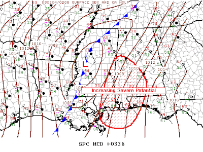
From the SPC:
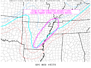
PRE-FRONTAL AIR MASS WILL DESTABILIZE THROUGH THE PERIOD OWING
LARGELY TO A MOISTENING BOUNDARY LAYER WITH DEWPOINTS INCREASING
THROUGH THE 60S FROM THE SABINE RIVER VALLEY EWD ACROSS MUCH OF THE
LOWER MS VALLEY INTO THE CNTRL/ERN GULF STATES.  THE STRONGEST
INSTABILITY IS FORECAST ACROSS SERN TX...LA AND CNTRL/SRN MS WHERE
RICHER BOUNDARY LAYER MOISTURE WILL COMBINE WITH DIABATIC HEATING TO
SUPPORT MLCAPES OF 1000-1500 J/KG.  INSTABILITY WILL TEND TO
DECREASE WITH NWD AND EWD EXTENT ACROSS THE REGION.

VERTICAL SHEAR WILL BE QUITE STRONG /MOST NOTABLY ALONG THE
MIGRATORY LLJ AXIS/ WHERE EFFECTIVE BULK SHEAR AND SRH VALUES SHOULD
EXCEED 45-50 KT AND 300-400 M2/S2 RESPECTIVELY.  THUS POTENTIAL WILL
EXIST FOR SUPERCELLS /SOME LONG-LIVED/ EMBEDDED WITHIN LARGER-SCALE
QLCS AND/OR IN ADVANCE OF MAIN CONVECTIVE SYSTEM WITH A THREAT OF
SIGNIFICANT TORNADOES ALONG WITH HAIL.  CORRIDORS OF DAMAGING WIND
ALSO APPEAR LIKELY /NAMELY WITH ANY LARGER-SCALE BOWS/ GIVEN
STRONG...AMBIENT WIND FIELDS AND RESULTANT FAST STORM MOTIONS.
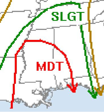
From NWS Birmingham:
HE BIG SHOW COMES MONDAY NIGHT. SPC HAS US IN A SLIGHT RISK
AREA...ALTHOUGH WE ALSO NOTE THAT THE HATCHED 30 PERCENT AREA
EXTENDS ARE FAR EAST AS BHM AND ALMOST TO SELMA...AND THE MDT RISK
(AND THE HATCHED 45 PERCENT) IS RIGHT ON OUR DOORSTEP. THE
SYNOPTIC PATTERN PREDICTED BY THE MODELS CERTAINLY SUGGEST A
FAIRLY HIGH POTENTIAL FOR SEVERE WEATHER. MOISTURE AND LIFT WILL
NOT BE LACKING MONDAY NIGHT...AND A 70+ KNOT LOW LEVEL JET CANNOT
BE IGNORED. THERE`S SHEAR A-PLENTY...BUT THE MODELS ONCE AGAIN
SEEM TO HOLD BACK ON THE INSTABILITY. IF ONE WERE TO TWEAK THE
DEWPOINT AT BHM AT 21Z MONDAY FROM 58F (AS FORECAST) TO 62F (WHICH
IS CERTAINLY POSSIBLE)...THEN THE SBCAPE JUMPS FROM LESS THAN 700
TO MORE THAN 1600. I`M NOT ALL THAT COMFORTABLE IN ASSUMING THAT
DEWPOINTS WILL ONLY MAKE IT INTO THE 50S...AND EQUALLY UNEASY
ABOUT HOW MUCH TEMPS FALL AFTER SUNSET MONDAY (GIVEN THE STRENGTH
OF THE LOW LEVEL WINDS). NOT TO MENTION THAT IT IS MARCH...AND
CLIMATOLOGICALLY THIS BEGINS THE HEART OF OUR SEVERE WEATHER
SEASON.

SO...WE ARE EXPECTING A SEVERE STORM THREAT THAT COULD BEGIN AS
EARLY AS 8 PM MONDAY NIGHT (IN THE WEST)...AND COULD LAST AS LATE AS
8 AM TUESDAY MORNING (IN THE EAST). BUT THE PRIMARY THREAT TIME
(BASED ON CURRENT MODEL SOLUTIONS) IS PROBABLY CLOSER TO 10 PM TO 6
AM. ALL SEVERE WEATHER THREATS ARE IN PLAY...INCLUDING TORNADIC
SUPERCELLS JUST AHEAD OR ALONG THE EXPECTED QLCS.


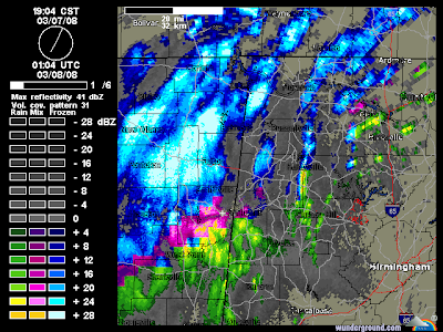
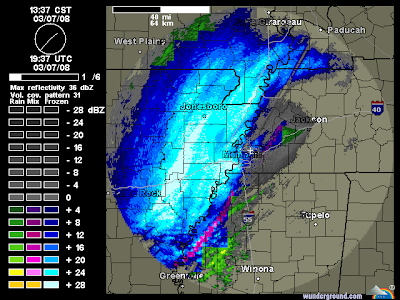
 Huntsville continues the Winter Storm Watch for its entire county warning area. They are predicting 1 to 3 inches at this time with up to 5 inches in extreme Northwest Alabama and also in higher elevations. Later this afternoon portions of the area may be placed under a warning.
 Birmingham has issued a Heavy Snow Warning for Marion, Lamar, Fayette, Winston, and Walker, Blount, Etowah, and Cherokee Counties. They are expecting accumulations up to 2.5 inches in these areas between 6 this evening and 10 tomorrow morning.
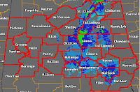 Birmingham has also issued a Heavy Snow Warning for numerous other counties in Central Alabama. Cities included in this warning include: Anniston, Tuscaloosa, Birmingham, Talladega, Moundville, Clanton, Demopolis, Selma, Prattville, Auburn, Montgomery, Troy, and Phenix City. Noth of the I-20 corridor accumulations will be up to 1.5" and accumulations of up to one-half an inch may occur in the southern part of the warned area.