Wednesday, October 29, 2008

Today on the Alabama Gulf Coast

Update: James Spann did this broadcast while I was at this location.


Here are some pictures I took today in Gulf Shores and Orange Beach, Alabama during a very cool October day.


Sunset in Gulf Shores, Alabama


Sunset in Gulf Shores, Alabama


Sunset in Gulf Shores, Alabama


Sunset in Gulf Shores, Alabama


ABC 33/40 Gulf Shores Skycam


Taken just after Noon at the Perdido Beach Resort in Orange Beach, Alabama


Sunrise in Gulf Shores, Alabama


Sunrise in Gulf Shores, Alabama


Just before sunrise in Gulf Shores, Alabama


Just before sunrise in Gulf Shores, Alabama

Cold morning at Gulf Shores

North Alabama has been in the deep freeze during the last couple of mornings.

This morning I am on the Alabama Gulf Coast at Gulf Shores. The Temperature is 42, on block away from my location at the ABC 33/40 Skycam site. A couple of miles off the coast, at the Jack Edwards Airport it is 36. It is 40 over at Bon Secour.

I will be in meetings most of the day (unfortunately) but when I can "steal" a minute I will be out taking pictures.

Friday, October 24, 2008

Montgomery

Photobucket Album


This is what Montgomery looked like Wednesday evening, as the clouds were moving in ahead of the big rain that we have had since 4 p.m. yesterday.

Sunday, October 19, 2008

Beautiful autumn day


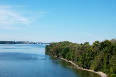
This afternoon, on the Tennessee River, looking west toward Decatur

Does it get any nicer than this? Not if you like sunny skies, a slight breeze, and high temperatures near 70 degrees.

The weather in North Alabama has been very comfortable, generally dry, and pleasant over the past month. We have had very few problems with severe weather in the State, and there has not been much to write about.

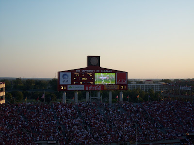
I am not complaining. This nice weather has given me a great opportunity to take a break from blogging. When the weather gets nasty, I will be back at it with a vengeance. It has been a great fall to be an Alabama Crimson Tide football fan and I have been enjoying watching Coach Saban and the guys roll over their first seven opponents, on their way to a number two national ranking (so far).

The next chance for storms around here will be this coming Friday. At this time there is no clear indication that this will be a severe weather event, but it bears watching.

We are entering our secondary tornado/severe weather season, so everyone should pay very close attention to the forecasts during the next few months.

I will be on business trips to Montgomery and Orange Beach the next two weeks. That, along with some issues with my laptop, may make it difficult for me to post this week.

Saturday, October 18, 2008

A story from the aftermath of the 2/17/08 Prattville tornado

EMA thanks Church of Living Water for help during storms
from the Prattiville Progress.com

A local church that served as the nerve center for relief efforts during the aftermath of the Feb. 17 tornado was honored recently by emergency management offi­cials.

Church of the Living Water was presented with the Alaba­ma Emergency Management Community Service Award by state and local officials for the role the church played in the Prattville tornado recovery ef­forts. The church served as the city's service center during re­covery efforts, as volunteer and service organizations con­ducted operations from the church so as to get help to af­fected residents more quickly.

"After the tornado, the church opened its doors to help anybody in the community and then willingly opened their doors to become the service cen­ter," said Crystal Ousley, inter­im director of the Autauga County EMA. "We set up the center to provide services from community groups like the Red Cross and Salvation Army, and social services for the tornado victims in that area. It was a central place, with all the dam­age in that area. During recov­ery besides the volunteer recep­tion center that was held at Pratt Court, they were the other heartbeat of the recovery pro­cess."


Click on the title to read the whole story.

Wednesday, October 15, 2008

This morning's sunrise


Severe Weather Awareness Day

Huntsville NWS

Birmingham NWS Video included.

...

Tuesday, October 14, 2008

Weather folklore

I was fortunate to grow up next door to a wise gentleman named Mr. Smart who grew up in the the hills of southeast Tennessee, near Tracy City. He taught me the name of every tree in our neighborhood, took me to his parents' farm to dig up potatoes in October, and shared lots of folklore with me. I wish I could remember half of it.

One thing he taught me about weather folklore I will never forget. We had a persimmon tree in our yard in Huntsville. One day he took the seed out of the persimmon, sliced it long-ways with his pocket knife, and told me that we would have a warmer than usual winter because of the fork shape inside the seed. He told me that if the inside was shaped like a spoon we would have a colder than average winter. I don't know if that method works, but it was interesting nonetheless. The persimmon tree is long gone. It was blown down in a severe storm years ago.

Friday, October 10, 2008

From Alaska...

ABC 33/40 Skywatcher Todd Foisy contibuted this storm report from Alaska this evening on the Skywatcher IM conference:

Girdwood, Alaska: High 42.3/Low 35.4/Current 40.5/Rain 2.78"/Snow Depth 1" An exceptional storm system last night. Winds gusted to 100 mph in some areas (not here thankfully) and did some significant damage in portions of Anchorage and Eagle River, knocking some roofs off houses and downing plenty of trees. Storm total precip here was 3.21" over about 24 hours, falling first as wet snow yesterday but changing to rain. The mountains got multiple feet of snow, as did some lower elevations sites north of here.

....

Tornadoes 10/8/08 in Alabama


0530 AM - 5 NNW CARBON HILL - WALKER - EMERGENCY MNGR
A BRIEF TORNADO TOUCHED DOWN NEAR THE INTERSECTION OF
KENDRICK ROAD AND DOGTOWN ROAD. THE TORNADO HAS BEEN
RATED AN EF0. ONE CHICKEN HOUSE SUSTAINED MAJOR DAMAGE, A
FEW TREE TOPS WERE SNAPPED OFF, TWO OUTBUILDINGS SUFFERED
MINOR DAMAGE, AND A FEW TREES WERE UPROOTED. THE PATH WAS
APPROXIMATELY 0.4 MILES LONG AND 40 YARDS WIDE.

0319 PM - 3 W WINFIELD - F0 - MARION - EMERGENCY MNGR
A WEAK TORNADO TOUCHED DOWN JUST WEST OF WINFIELD. THIS
LOCATION WAS CLOSE TO THE INTERSECTION OF COUNTY ROAD 27
AND COUNTY ROAD 69. THE TORNADO WAS CAPTURED ON FILM BY
MORE THAN ONE CITIZEN. NO DAMAGE WAS REPORTED. SEVERAL
ADDITIONAL FUNNEL CLOUD REPORTS WERE RECEIVED ASSOCIATED
WITH THIS FEATURE NOT ON THE GROUND.

0322 PM - GU-WIN - MARION - EMERGENCY MNGR
POSSIBLE BRIEF TORNADO TOUCH DOWN NEAR GU-WIN. NATIONAL
GUARD PERSONNEL REPORTED A FUNNEL CLOUD POSSIBLY ON THE
GROUND BUT BECAME RAIN WRAPPED. SEVERAL ADDITIONAL
REPORTS WERE RECEIVED FROM THE SAME AREA OF A FUNNEL
CLOUD POSSIBLY REACHING THE GROUND BUT NO DAMAGE
REPORTED.

---

...TORNADO NUMBER 1 (ENTERPRISE ALABAMA AND FORT RUCKER ALABAMA)...
A STORM SURVEY WAS CONDUCTED IN CONJUNCTION WITH THE COFFEE COUNTY
EMERGENCY MANAGEMENT AGENCY ON WEDNESDAY AFTERNOON. THIS TORNADO
TOUCHED DOWN IN THE CITY OF ENTERPRISE NEAR THE CIVIC CENTER AROUND
1155 AM CDT. THIS TORNADO CONTINUED ALONG THE GROUND FOR ANOTHER 1.5
MILES BEFORE LIFTING NEAR WHERE US HIGHWAY 84 CROSSES THE
RAILROAD DOWNTOWN. ADDITIONAL SPORADIC DAMAGE WAS REPORTED FURTHER
TO THE EAST OF BOLL WEEVIL CIRCLE NEAR THE WALMART. THE PARENT
THUNDERSTORM THAT PRODUCED THIS TORNADO CONTINUED FURTHER TO THE
EAST AND CROSSED INTO DALE COUNTY ALABAMA WITH ANOTHER TORNADO
TOUCHDOWN ON FORT RUCKER MILITARY BASE. DAMAGE OCCURRED ALONG
AIRPORT ROAD AND ANDREWS AVENUE. THIS TORNADO CONTINUED TO A POINT
ABOUT 5 MILES SOUTH OF OZARK...TOWARD STATE ROUTE 123 WHERE A ROOF
WAS PARTIALLY REMOVED FROM A RESIDENCE NEAR LOGAN ROAD.

THE DAMAGE RATING FOR THE TORNADO IN ENTERPRISE IS AN EF-1 WITH
MAXIMUM WINDS OF 100 TO 105 MPH NEAR THE CIVIC CENTER. DAMAGE RATED
AT EF-0 WITH WINDS OF 75 TO 80 MPH WAS ASSESSED AT THE WALMART.

THE DAMAGE RATING FOR THIS TORNADO IN DALE COUNTY FROM FORT RUCKER
MILITARY BASE TO A POINT 5 MILES SOUTH OF OZARK IS AN EF-0 WITH
MAXIMUM WINDS OF 80 MPH. THE TIME OF THE TORNADO TOUCHDOWN NEAR FORT
RUCKER WAS 1215 PM CDT AND LIFTED AT 1230 PM CDT SOUTH OF OZARK. THE
DAMAGE PATH WAS INTERMITTENT.

...TORNADO NUMBER 2 (DALE-HENRY COUNTY LINE INTO HENRY COUNTY)...
THE SAME STORM THAT PRODUCED A TORNADO IN COFFEE AND WESTERN DALE
COUNTY CONTINUED SLOWLY EAST AND PRODUCED A SECOND TORNADO NEAR THE
DALE-HENRY COUNTY LINE AROUND 128 PM CDT. THIS TORNADO MOVED INTO
HENRY COUNTY AND DAMAGED A HOME NORTH OF STATE ROUTE 27. THE CARPORT
ATTACHED TO THE HOME WAS DESTROYED. THE DAMAGE SURVEY ESTIMATES THAT
WINDS UP TO 85 MPH PRODUCED THE DAMAGE FROM THIS SYSTEM. THUS...THE
TORNADO IS RATED AN EF-0.

...TORNADO NUMBER 3 (HOUSTON COUNTY NEAR WICKSBURG)...
A NORTHWARD MOVING STORM ENTERED THE WESTERN PANHANDLE OF HOUSTON
COUNTY AND PRODUCED A TORNADO NEAR THE COMMUNITY OF WICKSBURG JUST
NORTH OF US HIGHWAY 84 NEAR THE INTERSECTION WITH STATE ROUTE
123. THIS TORNADO DAMAGED A FEW CARS AT AN AUTO DEALERSHIP AND
UPROOTED A FEW TREES NEAR THE DALE/HOUSTON COUNTY LINE. THIS TORNADO
DID NOT PRODUCE ANY ADDITIONAL DAMAGE WHEN IT BRIEFLY TOUCHED DOWN
NEAR PINCKARD IN DALE COUNTY. THIS TORNADO FIRST TOUCHED DOWN NEAR
WICKSBURG AROUND 105 PM CDT. THIS TORNADO WAS RATED AN EF-0.

Thursday, October 09, 2008

Rain totals

Yesterday I recorded 3.59" of rain.

These are some of the highest CoCoRaHS totals:.

Location
Rainfall
Orange Beach 2.1 NE 8.97 AL Baldwin View
Orange Beach 2.5 ENE 8.70 AL Baldwin View
Orange Beach 3.0 ENE 7.82 AL Baldwin View
Elberta 1.8 SSW 5.98 AL Baldwin View
Elberta 3.1 SSW 5.55 AL Baldwin View
Foley 2.0 SSW 5.03 AL Baldwin View
Harvest 4.8 SSW 4.11 AL Madison View
Elberta 8.2 ESE 3.96 AL Baldwin View
Waterloo 8.7 ENE 3.80 AL Lauderdale View
Foley 0.5 ESE 3.71 AL Baldwin View
Vinemont 0.2 ENE 3.59 AL Cullman View
Huntsville 3.9 N 3.57 AL Madison View
Falkville 5.1 E 3.55 AL Morgan View
Foley 6.2 SW 3.39 AL Baldwin View
Ozark 2.7 NNW 3.34 AL Dale View
Fayette 1.9 NNE 3.33 AL Fayette View
Huntsville 7.2 SE 3.30 AL Madison View
Madison 2.6 SSE 3.19 AL Madison View
Madison 1.2 E 3.04

Wednesday, October 08, 2008

Driving through a downpour this morning

This is what it was like driving to work this morning...

Autumn in Alabama


Street sign on a beautiful Autumn day in Montgomery, Alabama near Robert E. Lee High School, just off of Ann Street.


Sunset in Montgomery 10/3/2008


October 3, 2008 on I-65 at Lacon Mountain in South Morgan and North Cullman counties of Alabama.


West Point, Alabama sunrise on 10/3/08.


Sunset at Bryant-Denny Stadium just before the Alabama Crimson Tide defeated the Kentucky Wildcats on Saturday October 4, 2008.


Looking toward the College of Communication at the University of Alabama. I took many classes here as I worked towards my undergraduate degree.


I took this photo at 7:30 this morning in Decatur, Alabama on 6th Avenue after a very heavy deluge that dropped over 3" of rain in many parts of North Alabama.


I took this photo just after 4 p.m. today just off AL Hwy 157 after attending a funeral today in Moulton. This is the edge of the tornado damage from the February EF4 tornado in Lawrence County.

Rain, Rain, Rain

Between 6:45 and 7:30 I saw very dark skies, torrential rain, lightning, and flooding between Huntsville and Decatur. Many low areas of Decatur under water.

I have a few pics to post later tonight.

....

Tuesday, October 07, 2008

Rain

The rain is starting a bit earlier than expected and one-half an inch or more seems likely for Alabama.

...

Monday, October 06, 2008

Rain on the horizon?

The weather has been extremely quiet lately in Alabama and so I have I. I apologize for the lack of posts lately but sometimes a well-timed break is good for us in the long run. I have been travelling a lot with my job and keeping up with the undefeated and number two ranked Alabama Crimson Tide quite a bit so far this autumn. I continue to take pictures and I plan on sharing some of the scenes I have encountered on this blog soon.

After Gustav the tropics really settled down and rain has been practically non-existent in Alabama for the past month. Unfortunately the drought has not ended. Every time we take a step forward in our rainfall, we take another step or two back. It looked for awhile like the massive rainfall totals Alabama received from Fay might just break the drought here in Alabama, but we have seen precious few drops since then.

The good news is that we will likely see some significant rain soon. A strong trough will approach Alabama on Wednesday and much of the State could receive at least one-half inch, with more in isolated locations.

...
Newer Posts Older Posts Home