Wednesday, February 28, 2007

Severe Weather Outlook Update


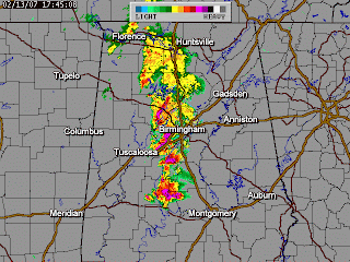
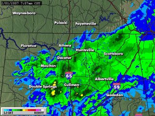
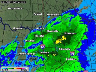
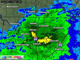
The threat of severe weather tomorrow is increasing, according to the Storm Prediction Center in Norman, Oklahoma. Below is an exerpt from their latest outlook.

DAY 2 CONVECTIVE OUTLOOK NWS STORM PREDICTION CENTER NORMAN OK 1139 AM CST WED FEB 28 2007 VALID 011200Z - 021200Z

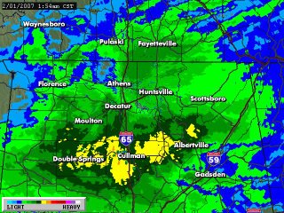
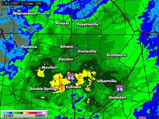
...THERE IS A MDT RISK OF SVR TSTMS PORTIONS LA...AR...MO...IL...SWRN INDIANA...WRN KY...WRN/MID TN...MS...AL...GA...SC...

OUTBREAK OF SVR TSTMS -- INCLUDING CONDITIONAL POTENTIAL FOR STRONG-VIOLENT TORNADOES -- WILL AFFECT PORTIONS E-CENTRAL/SERN CONUS. UNCERTAINTIES REGARDING INSTABILITY AND CONVECTIVE MODE REMAIN ATTM...PRECLUDING HIGH PROBABILITIES THIS SOON. HOWEVER...AN UPGRADE OF SOME PORTION OF CATEGORICAL MDT RISK AREA IS POSSIBLE IN FUTURE OUTLOOKS VALID FOR THIS PERIOD. ...


...MID SOUTH...MS/AL... MAXIMIZED SFC HEATING WILL COINCIDE WITH OPTIMAL VERTICAL SHEAR AND INCREASING LOW LEVEL MOISTURE TO MAXIMIZE RISK FOR SVR HAIL...WIND...AND IN PARTICULAR...SIGNIFICANT TORNADOES. ALTHOUGH MIDLEVEL LAPSE RATES MAY REMAIN AOB 7 DEG C/KM...SFC DEW POINTS SHOULD INCREASE INTO 60S F ALONG AND S OF MARINE FRONT. THIS WILL SUPPORT POCKETS OF MLCAPES 500-1000 J/KG...WHERE BREAKS IN CLOUD COVER OCCUR BEHIND EARLY-PERIOD PRECIP ASSOCIATED WITH STRONG WAA REGIME. THIS WILL BE SUITABLE FOR TORNADIC SUPERCELLS AND BOWING LINE SEGMENTS IN ENVIRONMENT CHARACTERIZED BY LARGE LOW LEVEL HODOGRAPHS -- 0-1 KM SRH AOA 300 J/KG -- AND 0-6 KM SHEAR EXCEEDING 60 KT. A FEW LONG-LIVED AND LONG-TRACK SUPERCELLS ARE POSSIBLE GIVEN STRENGTH OF DEEP-LAYER KINEMATIC PROFILES AND RAPID NEWD SPREAD OF FAVORABLE INFLOW-LAYER MOISTURE.

Moderate Risk Tomorrow

The Storm Prediction Center has placed central Alabama under a "moderate risk" for severe weather tomorrow. Jason Simpson, of alabamawx.com said this morning , "the primary threats will be from wind & hail with the risk of a few tornadoes, too. That tornado threat increases greatly if storms start out isolated out ahead of a main line that will sweep through late Thursday evening." James Spann, also of alabamawx.com said, "if the rain ends by mid-morning and the sun breaks out for a while, that would set the stage for numerous supercell storms tomorrow afternoon and tomorrow evening with the chance of significant tornadoes.The greatest window for significant severe weather will be from about 2:00 p.m. until 9:00 p.m."

Stay tuned!

High Risk

The Storm Prediction Center has placed much of Alabama under a very unusual "HIGH RISK" of severe weather today for a possibility of an outbreak of potentially strong or violent tornadoed.

A "HIGH RISK" means that there may be an outbreak of at least 20 tornadoes in a 50,000 square mile area (roughly the size of the state of ALabama) with at least two rated EF3 or greater or an extreme straight line wind event with over 50 areas of 80+ mph wind and major structural damage.

Following is the text of this outlook from the SPC:

…THERE IS A HIGH RISK OF SVR TSTMS TODAY ACROSS PARTS OF ERN
MISSISSIPPI AND ALABAMA…WHERE POTENTIAL EXISTS FOR AN OUTBREAK OF
TORNADOES…SOME POSSIBLY STRONG OR VIOLENT….

…THERE IS A MDT RISK OF SVR TSTMS SURROUNDING THE HIGH RISK
AREA…ACROSS MUCH OF THE LOWER HALF OF THE MISSISSIPPI VALLEY AND
GULF/SOUTH ATLANTIC COAST STATES….

…THERE IS A SLGT RISK OF SVR TSTMS TODAY/TONIGHT ACROSS A LARGE
PORTION OF THE CENTRAL/EASTERN STATES….

LARGE SCALE PATTERN ACROSS THE U.S. DURING THIS FORECAST PERIOD WILL
BECOME DOMINATED BY A DEEP CYCLONE NOW DEVELOPING ACROSS THE CENTRAL
PLAINS…IN RESPONSE TO AN INTENSE MID/UPPER JET STREAK NOSING
NORTHEAST OF THE SOUTHERN ROCKIES. UPPER JET CORE IS PROGGED TO
SHIFT THROUGH THE SOUTHERN PLAINS/NORTHERN GULF STATES AND SOUTHERN
APPALACHIANS TODAY THROUGH EARLY FRIDAY…WITH SURFACE CYCLONE
GRADUALLY OCCLUDING AS IT LIFTS THROUGH THE UPPER MISSISSIPPI
VALLEY/UPPER GREAT LAKES REGION. AS THIS OCCURS…A COLD FRONT WILL
SURGE EAST OF THE MISSISSIPPI VALLEY…LIKELY REACHING ATLANTIC
COASTAL AREAS BY 12Z FRIDAY. AND…MODELS SUGGEST SECONDARY SURFACE
CYCLOGENESIS MAY OCCUR FROM THE LEE OF THE NORTH CENTRAL
APPALACHIANS INTO NORTHERN MID ATLANTIC COASTAL AREAS.

Tuesday, February 27, 2007

Risk of Severe Weather Thursday

I will post more later but it looks as though North Alabama will be in the bull's eye for severe weather Thursday. At the moment, the timing for storms is projected to be late afternoon and early evening. Stay tuned.

Sunday, February 25, 2007

Thankfully...

Thankfully the weather in Alabama last night was not that bad. In fact, most of the damage that occurred was trees that were blown down by pressure gradient winds that exceeded 50 mph prior to the arrival of the storms. Arkansas was no so fortunate.

Saturday, February 24, 2007

Tornado Watch


Most of Alabama is under a tornado watch from 9 p.m. until 3 a.m.

Tonight's Forecast


At 6:30 a line of severe storms is parallel to the Mississippi River, approximately 30 miles to the east. Some storms ahead of this line may reach Alabama by 9 or 10 pm, but the main line of storms will be near western Alabama between 9 and 10 and I-65 around midnight. There are tornado warnings at this time in Mississippi. There will probably be a few isolated tornadoes in Alabama tonight, more likely west of I-65. The main threat, however, will be from strong straight line winds that could exceed severe limits (58 mph and higher).

Photos from Dumas, AR

Major Damage in SE Arkansas

Arkansas Damage, by James Spann, Alabamawx.com

Dumas, Arkansas Tornado was Significant, Bill Murray, Alabamawx.com

Tornado Threat Increasing for MS


Per the Storm Prediction Center

Tornadoes in Arkansas


Radar image is from KATV in Little Rock at approximately 3:40 p.m.
Reports are coming in of major tornado damage in Dumas, Arkansas.

PDS Tornado Watch in Mississippi Until 9 p.m.


Severe Weather Tonight

As previously mentioned, conditions will become favorable for severe weather to develop in Alabama tonight. More to come.

Wednesday, February 21, 2007

Flurries Saturday 2/17/07

Storm Alert 2007

The ABC 33/40 Storm Alert 2007 tour came to Oneonta on February 8, 2007. The boys and I had a good time, learned about weather, and enjoyed talking to the meteorologists.


Brian Peters


Ashley Brand


Jason Simpson


Spann, Peters, Simpson, Brand


James Spann

Severe Weather Threat This Weekend

Early indications from computer models continue to show a potential severe weather threat in Alabama Saturday night and Sunday. The models have consistently shown a storm during this general time frame for many days now. At the moment, a deep low pressure system is expected to trek from Amarillo, Texas to Chicago this weekend. Timing, as always, is critical. Although severe weather can (and does) occur at any time of the day or night, conditions are usually worse if the storms hit during the afternoon hours. Currently the models are putting Alabama in the most dangerous weather Sunday morning.

I am really concerned about this one. It seems like many of our worst tornadoes have hit during church hours.

  • The Piedmont Tornado on Sunday March 24, 1994 destroyed the Goshen United Methodist Church during Palm Sunday Services at 11:37 a.m.
  • The Brent Baptist Church in Bibb County was destroyed on Sunday May 27, 1973.
  • Churches were also struck during the Superoutbreak on Wednesday April 3, 1974, between 3 and 9 p.m.
  • The Oak Grove Tornado on April 8, 1998 in Jefferson County was on a Wednesday night during church services.

All churches need to have someone to monitor the weather and a plan of action in the event of a tornado emergency.

Thursday, February 15, 2007

Today's Weather Window


Wednesday, February 14, 2007

Snow Flurries and a Sunset


Sunset in North Alabama

Snow Flurries This Morning

Tuesday, February 13, 2007

Midwest Snow

While the Deep South encounters severe weather, Illinois and the Midwest is seeing heavy snow. My sister may send me some photos from her neighborhood on the north side of Chicago. She was allowed to work online from home today due to the heavy snow in the Chicago area.

Look Out Montgomery

Very strong circulation shown on radar WNW of Montgomery at the moment. Possible tornado.

Lots of Hail Reports From Tuscaloosa

I will link photos from Tuscaloosa hail reports here. ABC 33/40 has shown photos of golfball to baseball sized hail.

Damage Report


Damage on the Tuscaloosa/Bibb County Line at 5:40 on Highway 219.

Tornado Warning for far southern Shelby County. This tornado passing along Bibb/Shelby County line. It may pass near Wilton, Montevallo and Calera.

Perry County storm will pass between Plantersville and Burnsville near Jones.

---

5:23p.m. Quarter sized hail 3 miles east of Duncanville in Tuscaloosa County…

5:44p.m. Quarter sized hail 4miles north of Selma

5:47p.m. TORNADO 6 miles NW of Centreville…near County Road 1 and Hwy 82…3 houses damaged…trees and power lines down

5:47p.m. Quarter sized hail in Oak Grove in western Jefferson County

5:55p.m. Penny sized hail in Bessemer

5:55p.m. Quarter sized hail at Hueytown and 2 miles east of Hueytown a short time later

The above reports were courtesy of JB Elliott of Alabamawx.com

Tornado Threat Continues

Tornado Warning in Bibb County. Funnel North of Newburn. Tornado reported near Greensboro. Latest is the tornado may be headed toward Marion in Perry County. Posted at 5:08. NWS Birmingham reports circulation passed right over Newburn. ABC 33/40 Meteorologist Jason Simpson reports an increase in lightning and circulation in SE Tuscaloosa and Northwestern Bibb, approaching the Eoline community.

Multiple reports coming in of golfballsized hail on Hwy 82 between Duncanville and the Bibb County line.

Tornado Warnings in Alabama


National weather Service Birmingham reports at about 5:00 that a tornado is on the ground near Greensboro in Hale County.


Lamar, Tuscaloosa, Pickens, Hale, Greene, and Marengo Counties at 4:30.

Golfball sized hail in Greene County. The dangerous part of the storm will pass 10 miles south of downtown Tuscaloosa. In a matter of minutes it will pass over Highway 69. Posted 4:36.

Things are looking worse to the south, west of Greensboro, in Hale County. Strong indications of rotation just west of Grensboro. Posted at 4:50.

Tornado Warning issued at 4:54 for Hale and Perry Counties.

Baseball sized hail (2.75") reported at Newburn, AL in Hale County at about 4:55.

Storms Today


At 7:18 this morning I saw a huge cloud to ground lightning strike southeast of Decatur. There was heavy rain between Priceville and Decatur between 7:20 and 7:30. You can see that represented above on radar images from ABC 33/40 in Birmingham and WAFF 48 in Huntsville.
Severe storms have occurred to our west with reports of damage in Louisiana and Mississippi from possible tornadoes. Another round of strong to severe storms is expected to roll into Alabama this afternoon with the passage of a cold front. The greatest chance for tornadoes and severe weather is in Central and South Alabama. However, the Storm Prediction Center has all of Alabama in the "slight risk" category for severe weather today.

Friday, February 09, 2007

Threat of Wintery Precip This Morning

It is 28.4 in Vinemont in northern Cullman County at 6:25 a.m.

Thursday, February 08, 2007

Winter is Not Over

During the upcoming weeks, weather will continue to be unsettled across the South. There are two possible winter storm events (Feb 15. and 17-18) and one possible severe weather event (Feb. 12-13). This is a time to pay close attention to the forecasts every day because it is too early to make an actual forecast.

Significant snow can happen much more often around here than it has in recent years. Does anyone remember the snow on January 18, 1992? I lived in Tuscaloosa and we had exactly 6 inches on a Saturday. I was showing the home video I took of the event to my boys this past weekend. I wish I had a way to upload some of that to YouTube.

This Morning

This morning in northern Cullman County we had some light freezing rain. The temperature was 32 degrees and as I was driving to work, the rain froze on my windshield, making it hard to see. I turned my defroster on and melted some of it off, but as soon as I turned the fan off, it started freezing again.

Florida Tornadoes

There were two excellent posts about this tragedy that occurred last week on Alabamawx.com by Bill Murray. Rather than writing about it myself, I will refer you to those posts.

One thing I will say is this: My biggest pet peeve is that every time a tornado takes lives, media outlets proclaim that the tornado hit "without warning", when in most cases that is simply not true. That happened again in this situation. I even heard someone on the Weather Channel say this. CNN said it. Many others did as well.

The truth is that the NWS did issue warnings for the tornadoes. The problem is that many people have not taken the responsibility for putting themselves in a position to hear the warnings. Everyone should have a weather radio, just as everyone should have a fire alarm. I do not believe sirens are the answer.

Florida Tornadoes Rated as Stong EF3's

A Preventable Tragedy

Thursday, February 01, 2007

8 AM Update


At 8 a.m. light freezing rain is tapering off in Vinemont. The temperature is up to 32.2.

From Cullman County (Alabamawx.com) James Spann

The radar shots I have been using have been thanks to WAFF Channel 48 Doppler Radar in Huntsville, Alabama.

7 AM Update


At 7 a.m. in Vinemont light freezing rain continues and the temp is 32.0.

6 AM Update


At 6 a.m. it is 31.8 in Vinemont with freezing rain.

At 6:15 we are up to 32.0 in Vinemont and the freezing rain continues.

4 AM Update

2 AM Update


At 2 a.m., the temperature in Vinemont is 31.1. The precipitation has now changed over to mostly freezing rain, with some sleet mixed. Precip started just before 10 as sleet. Later, the sleet became mixed with snow. There was a brief changeover to all snow. Then we had a period of heavy sleet. Sleet was steady for a few hours, but it has now turned into mostly freezing rain. Roads are slushy and sleet covers grassy and elevated surfaces.

At 2:30 in Vinemont, freezing rain continues and the temp remains 31.1. Some of the sleet melted but freezing rain is accumulating on tree limbs.

2:45 - My last report for now...The temp seems to be rising 1/10th of a degree every 15-20 minutes or so. We continue to have a steady, moderate freezing rain. When the temp rises a few more degrees, we'll be in good shape. It sounds like areas to our north and east may not be so fortunate. It has been an interesting night and James did a great job with this system.

1 AM Update


At 1 a.m. in Vinemont, the temperature was 30.9 with moderate sleet. Sleet continues to accumulate. The High School Road at Vinemont is starting to get slushy.

At 1:30 p.m. in Vinemont, the temperature was 31.1 with sleet continuing, but now mixed with freezing rain.
Newer Posts Older Posts Home