Sunday, December 30, 2007

One for the record books?

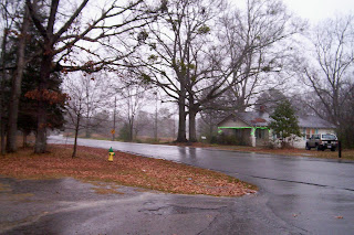
For the past few weeks I have been watching Birmingham's annual rainfall total with increasing interest. Brian Peters, meteorologist with Alabamawx.com has been documenting the possibility that Birmingham may end up with the driest year in 113 years of official record keeping.

As today's rain ended, Birmingham's rain total for 2007 unofficially stood at 28.86" with no more rain expected between now and tomorrow night when 2008 begins. If the 28.86" total stands, Birmingham will finish 2007 .14" below the previous record of 29.00"in 1895.

That would be an amazing record, but one that we wish did not occur.

Friday, December 28, 2007

Farmer uses pig spleens to forecast weather

A U.S. farmer can forecast a major snowstorm through his pig spleens instead of radar or other high-tech equipment, media reported on Monday.

Paul Smokov, 84, raising cattle on a 1,750-acre ranch north of the town Steel, North Dakota, forecasts the weather by peering at two of brown, glistening, foot-long spleens on his kitchen counter.

Tornado Warning - Perry, Bibb


TORNADO WARNING
NATIONAL WEATHER SERVICE BIRMINGHAM AL
154 PM CST FRI DEC 28 2007

THE NATIONAL WEATHER SERVICE IN BIRMINGHAM HAS ISSUED A * TORNADO WARNING FOR... SOUTHERN BIBB COUNTY IN CENTRAL ALABAMA... THIS INCLUDES THE CITY OF CENTREVILLE... NORTHERN PERRY COUNTY IN CENTRAL ALABAMA... * UNTIL 230 PM CST

* AT 150 PM CST...NATIONAL WEATHER SERVICE DOPPLER RADAR INDICATED A SEVERE THUNDERSTORM CAPABLE OF PRODUCING A TORNADO 6 MILES NORTHEAST OF MORGAN SPRINGS...OR 14 MILES NORTH OF MARION...MOVING EAST AT 35 MPH.

* THE TORNADO WILL BE NEAR... ELLARDS BY 200 PM CST... BRENT AND CENTREVILLE BY 215 PM CST...

At 11:45


Click image for animation


A line of strong storms moved through between 11:30 and 11:45. There are now some breaks in the clouds and the sun is trying to come out. The line is breaking up as it passes and the surface boundary is still to our west. I fully expect more storms before the afternoon is over. Great updates from Bill Murray over at Alabamawx.com. Shear is high in North Alabama and instability is increasing in South Alabama. Much of Alabama remain under a tornado watch.

Tornado Watch


Excerpt...

TORNADO WATCH NUMBER 745
NWS STORM PREDICTION CENTER NORMAN OK
1045 AM CST FRI DEC 28 2007

THE NWS STORM PREDICTION CENTER HAS ISSUED A
TORNADO WATCH EFFECTIVE THIS FRIDAY MORNING AND EVENING FROM 1045 AM UNTIL 600PM CST.

TORNADOES...HAIL TO 1 INCH IN DIAMETER...THUNDERSTORM WIND GUSTS TO 70 MPH...AND DANGEROUS LIGHTNING ARE POSSIBLE IN THESE AREAS.

DISCUSSION...A BROKEN BAND OF STORMS IS EXPECTED TO INTENSIFY ALONG THE COLD FRONT THIS AFTERNOON FROM SE LA INTO SE MS AND CENTRAL AL. FARTHER SE...PRE-FRONTAL STORMS WILL INCREASE IN COVERAGE ACROSS SRNAL THROUGH THE AFTERNOON. BOUNDARY LAYER DEWPOINTS IN THE 60S AND SURFACE HEATING WILL CONTRIBUTE TO SUFFICIENT INSTABILITY FOR SEVERE STORMS...AND VERTICAL SHEAR SHOULD REMAIN FAVORABLE FOR SUPERCELLS THROUGH THE AFTERNOON. A FEW TORNADOES AND DAMAGING WIND GUSTS WILL BE THE MAIN SEVERE STORM THREATS.

Quick note....

Great coverage, NWS Birmingham and Huntsville! Why is there not a watch or even a mesoscale discussion issued by the SPC?

Tornado Warning - Marshall


TORNADO WARNING
NATIONAL WEATHER SERVICE HUNTSVILLE AL
932 AM CST FRI DEC 28 2007

THE NATIONAL WEATHER SERVICE IN HUNTSVILLE HAS ISSUED A * TORNADO WARNING FOR... SOUTHERN MARSHALL COUNTY IN NORTHEAST ALABAMA...

* UNTIL 1000 AM CST *

AT 932 AM CST...NATIONAL WEATHER SERVICE DOPPLER RADAR INDICATED A SEVERE THUNDERSTORM CAPABLE OF PRODUCING A TORNADO 18 MILES SOUTHWEST OF ALBERTVILLE...OR ABOUT 9 MILES NORTH OF ONEONTA... MOVING NORTHEAST AT 45 MPH.

* LOCATIONS NEAR THE PATH OF THIS TORNADO INCLUDE... ALBERTVILLE. DOUGLAS. HORTON. BOAZ.

WHEN A TORNADO WARNING IS ISSUED BASED ON DOPPLER RADAR...IT MEANS THAT STRONG ROTATION HAS BEEN DETECTED IN THE STORM. A TORNADO MAY ALREADY BE ON THE GROUND...OR IS EXPECTED TO DEVELOP SHORTLY. IF YOU ARE IN THE PATH OF THIS DANGEROUS STORM...MOVE INDOORS AND TO THE LOWEST LEVEL OF THE BUILDING. STAY AWAY FROM WINDOWS. IF DRIVING...DO NOT SEEK SHELTER UNDER A HIGHWAY OVERPASS.

Warning continues until 10 a.m.


Tornado Warning - Blount, Etowah


BULLETIN - EAS ACTIVATION REQUESTED
TORNADO WARNING
NATIONAL WEATHER SERVICE BIRMINGHAM AL
923 AM CST FRI DEC 28 2007

THE NATIONAL WEATHER SERVICE IN BIRMINGHAM HAS ISSUED A TORNADO WARNING FOR...NORTHEASTERN BLOUNT COUNTY IN CENTRAL ALABAMA...

WEST CENTRAL ETOWAH COUNTY IN NORTHEAST ALABAMA...
* UNTIL 1000 AM CST

* AT 920 AM CST...NATIONAL WEATHER SERVICE DOPPLER RADAR INDICATED A SEVERE THUNDERSTORM CAPABLE OF PRODUCING A TORNADO NEAR EASLEY...OR NEAR ONEONTA...MOVING NORTHEAST AT 40 MPH.

* THE TORNADO WILL BE NEAR...

HENDRIX AND SUSAN MOORE BY 930 AM CST... 6 MILES SOUTHEAST OF SNEAD BY 935 AM CST... WALNUT GROVE BY 940 AM CST...

Severe risk in South Alabama


Lots of clouds this morning in North Alabama as we are now between two rounds of storms.


The SPC has moved the severe threat to the south and maintains a slight risk for SE Louisiana, SE Mississippi, the southern two thirds of Alabama, and Northwest Florida. Instability is weak in North Alabama (which is typical in December) and the strong low level jet will be ejecting to the northeast before the limited instability peaks. A few small tornadoes and isolated severe weather are still possible this afternoon to our south just prior to frontal passage.

5000

This blog has passed the 5000 mark in visitors according to sitemeter. I appreciate everyone who ever visits my little corner of the web. The weather sure is fascinating, isn't it? Over the past year and one half I have met several other weather enthusiasts and have made some really great friends.

"Some people are weatherwise, some are otherwise." - Ben Franklin

Thanks to every one of you weatherwise folks for visiting! May God bless each and every one of you in 2008!

Thursday, December 27, 2007

Severe threat update

Birmingham NWS in their AFD tonight says upper level dynamics, low level jet, and surface instability will only have a small window of opportunity to line up. Here is an excerpt:

STILL LOOKING AT THE POSSIBILITY OF SEVERE WEATHER TOMORROW. BOTH NAM AND GFS ARE IN GOOD AGREEMENT THAT THE BEST SURFACE BASED INSTABILITY WILL BE ALONG OUR SOUTHERN ZONES. HOWEVER...UPPER LEVEL DYNAMICS ARE NOT QUITE LINING UP IN THE RIGHT PLACE. A STRONG LOW LEVEL JET WILL ONLY HAVE A SMALL TIME FRAME WHERE IT CAN INTERACT WITH THE SURFACE INSTABILITY. EVEN THEN...IT WILL NOT BE IN THE RIGHT QUADRANT. BY LATE AFTERNOON AND EARLY EVENING...THE JET WILL QUICKLY MOVE NORTHEAST DEPLETING THE UPPER LEVEL SUPPORT AND THUS BEGIN TO SLOWLY WEAKEN THE LINE OF STORMS AS IT MOVE TO THE EAST. ALSO...HOW FAST CAN THESE LOW CLOUDS FIZZLE IN THE MORNING WILL ALSO PLAY A BIG ROLE. TIME FRAME RIGHT NOW THAT WE ARE LOOKING IS 10 AM THROUGH 6 PM.

My main reason to doubt the severe threat for North Alabama remains the lack of instability and daytime heating at the surface. Further south instability values may be higher but shear may not be as prevalent.

Severe storms tomorrow


The Storm Prediction Center has included most of the State of Alabama in a "slight risk" area tomorrow. Do not let the term "slight risk" confuse you. Usually severe weather will occur in your area when a slight risk is issued. This risk area very well may be upgraded to moderate tomorrow morning.
This thing does look nasty for tomorrow. The shear values may be really high. As always this time of year I question the amount of instability. Apparently with the SPC predicting convection way to our north, warm air advection will be stronger than usual, contributing to greater instability. I would not be a bit surprised to see a moderate risk issued by tomorrow morning.

Here is a portion of the SPC Convective Outlook, issued this morning:
LOWER MS VALLEY INTO TN VALLEY...PRIMARILY ELEVATED THUNDERSTORMS WILL BE ONGOING AT THE START OF THE PERIOD OVER PARTS OF LA AND MS IN ASSOCIATION WITH STRONG WARM ADVECTION AS A 50-60 KT SSWLY LOW LEVEL JET MOVES ACROSS THE LOWER MS VALLEY. MOISTURE IS EXPECTED TO CONTINUE INCREASING NWD DURING THE MORNING WITHIN THE EXPANDING WARM SECTOR...CONTRIBUTING TO AIR MASS DESTABILIZATION WITH MUCAPE OF 500-1000 J/KG FORECAST BY 15-18Z. FORECAST SOUNDINGS SUGGEST SURFACE-BASED CONVECTION WILL BECOME MORE LIKELY BY MID MORNING WITH AN INCREASING THREAT FOR A FEW SEVERE STORMS TO DEVELOP. VERY STRONG DEEP LAYER SHEAR /50 KT OR GREATER IN THE LOWEST 6 KM/ WILL ENHANCE STORM ORGANIZATION ANDINTENSITY AND PROVIDE A FAVORABLE KINEMATIC ENVIRONMENT SUPPORTIVE OF SUPERCELLS. IN ADDITION...VERY STRONG LOW LEVEL SHEAR AND SRH SUGGEST A POSSIBILITY FOR ISOLATED TORNADOES...MAINLY OVER PARTS OF SERN LA...SRN/ERN MS...NRN/WRN AL...AND NWRN GA THROUGH THE AFTERNOON HOURS.
Morning discussion exerpt from Jackson, MS (These guys do a good job):
FOR FRIDAY A WARM FRONT WILL PUSH ACROSS THE EASTERN HALF OF THE REGION AS A COLD FRONT MOVES ACROSS THE EAST PORTION OF THE REGION DURING THE AFTERNOON. THE SURFACE LOW WILL QUICKLY PUSH NORTHEAST ALONG THE FRONT DURING FRIDAY MORNING. SHOWERS AND SCATTERED EMBEDDED THUNDERSTORMS WILL MOVE ACROSS THE REGION. THE THUNDERSTORMS WILL BE GENERALLY ALONG AND AHEAD OF THE FRONT. IF THE GFS IS CORRECT WITH ITS LOW LEVEL MOISTURE RETURN...THEN SOME OF THE STORMS WITH THE FORCING AND INSTABILITY WILL BE STRONG TO SEVERE SOUTHEAST OF THE NATCHEZ TRACE WITH THE BEST CHANCE ALONG AND SOUTHEAST OF THE INTERSTATE 59 CORRIDOR. HOWEVER...THE 00Z ECMWF/UKMET ARE NOT AS ROBUST WITH RETURN FLOW AND THIS LENDS TO A BIT OF DOUBT IN THE GFS SOLUTION. LOOKING AT THE FORECASTED INSTABILITY BASED ON THE GFS...MID LEVEL LAPSE RATES ~6-7C...CAPES 300 TO 1600 J/KG ACROSS EAST AND SOUTHEAST MISSISSIPPI (BEST CAPES ALONG AND SOUTHEAST OF 59 CORRIDOR...LI -2TO -5... SHOWALTER INDEX...-1 TO -2...DEWPOINTS LOWER 60S (MAVGUIDANCE)...0-1 KM HELICITY >450...0-1 KM SHEAR AROUND 35 KNOTS. WITH THIS IN MIND WE WILL BE LOOKING AT ISOLATED STRONG TO SEVERE STORMS WITH DAMAGING WINDS...HAIL...AND ISOLATED TORNADOES...WHICH WILL BE OF GREATEST CONCERN ALONG THE INTERSTATE 59 CORRIDOR. FORECAST SOUNDINGS SHOW THAT CONVECTION MAY BECOME SURFACE-BASED IN THE RISK AREA. SUPERCELLS AHEAD OF THE COLD FRONT WILL NOT BE OUT OF THE QUESTION.

Wednesday, December 26, 2007

Favorite weather blog post of the year

It's time for the traditional and corny end of the year highlights to begin.

My favorite weather blog post this was the one James Spann posted on Alabamawx.com January 18, 2007, just before he did his 6 p.m. newscast, entitled, "'The Weather Channel' Mess". He was responding to the so-called climate expert Heidi Cullen of The Weather Channel who said that the American Meteorological Society should remove certification for broadcast meteorologists who do not believe in human induced global warming.

After his post was linked by Drudge and read in its entirety the next day by Rush Limbaugh, an unexpected firestorm ensued. James said that his normal busy email box went crazy. At one point he was receiving over 100 emails per minute.

This was my favorite post of the year because it represented a significant change. James was already one of the first meteorologists to challenge the "politically correct" view that global warming existed, was caused by human beings, and that anyone who disagreed was basically an uneducated flat-earth believing ignoramus. Now, to his surprise, he became a leading spokesman for the other side of the argument that supposedly didn't exist, according to people like Al Gore and Heidi Cullen. Since James spoke out, many, many more meteorologists have summoned the courage to follow.

James has become a leader of the opposition on this issue. One of the things he likes to remind people is to follow the money (on both sides of the issue). Try surviving as a meteorologist in a governmental agency which believes human induced global warming as gospel truth or try obtaining a government grant while not adhering to the party line on global warming.

What is sorely needed on this issue are independent scientists who are not biased by financial or other considerations who are willing and able to apply the scientific method. Thanks, James for taking the lead on this issue.

Big changes ahead

North Alabama will see a few decent opportunities for rain between now and the end of the year. It will be interesting to see if this will affect 2007's place in the record book for least rainfall. The first shot at rain will be this evening. Models are hinting at a greater amount of rain on Friday. This may depend on whether a mass of thunderstorms near the Gulf Coast chokes off our moisture supply.

The big news next week will be an intrusion of very cold air. Models have been pointing to this possibility for some time and it now appears likely that the coldest air of the season will arrive by this time next week. It is to early to pin down numbers, but it seems safe to say that temperatures will drop into the teens or lower. Highs will be in the 30's and we may have a day or two that we struggle to make it above freezing. Stay tuned!

Fog


This morning was very foggy here in North Alabama. Visibility was less than one tenth of a mile in many areas. This graphic from the NWS Huntsville shows conditions in Decatur, AL this morning.

Tuesday, December 25, 2007

Merry Christmas

I hope everyone had a great Christmas! I have been of the computer spending time with my family the last few days. I am a bit out of the weather loop, but I have heard that there may be some interesting weather in our future in Alabama. More on that later!

Saturday, December 22, 2007

S**w for Christmas in Alabama?

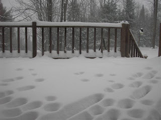
Dare I even mention the possibility of a white Christmas in North Alabama? Well, why not? Weather authorities such as UAH researcher and Alabamawx.com contributer Tim Coleman and the Huntsville NWS are mentioning it.

Check out this page from the NWS Huntsville about the history of White Chrismases in Huntsville, defined as having at least 1" of snow on the ground. Christmas of 1963 was the only year on record in which Huntsville had as much as 1" on Christmas.


The above forecast is from the NWS Huntsville Saturday morning. Tim Coleman has been posting about this possibility too. This is definitely something to keep an eye on as Chrismas Eve approaches.

See the corresponding discussion...


There is no doubt that The Midwest will be seeing snow, and lots of it this weekend. Check out Nathan's blog from Northern Wisconsin for updates.

Friday, December 21, 2007

Rainfall status

Yesterday we had .26" here in Vinemont. I do not know how far we are behind. I don't think records are kept here. Birmingham received .30". Birmingham now has received 27.67" this year which is 24.68" below average.

Thursday, December 20, 2007

Wind damage yesterday in Morgan County


Mississippi tornado

Miss. storm injures 3; possible tornado AP
Mike Womack, director of the Mississippi Emergency Management Agency, said he could not confirm whether a tornado had touched down Lincoln and Jones counties. Four structures in the Brookhaven area of Lincoln County and one in the Laurel area of Jones County were damaged, Womack said. At least two mobile homes were destroyed and two homes were damaged.
Lincoln County Sheriff Steve Rushing said a possible tornado touched down around 9 a.m. in a rural part of the county. Rushing said the person who was injured was in one of the mobile homes. He was identified as Bill Beasley.

More storm damage in MS


From J.B. Elliott at Alabamawx.com:

The EMA Office in Jones County, Miss., advises a severe thunderstorm struck 5 miles west of Laurel at 10:23 this morning.

* Several mobile homes were damaged or destroyed.
* Numerous trees uprooted.
* Some people were trapped in one mobile home.
* Several homes unroofed.

More storm damage in Mississippi


J.B. Elliott has passed on this storm report from the NWS/Jackson: "5 E Laurel [Jones Co, MS] emergency mngr reports TSTM WND DMG 10:33 AM CST -- mobile home rolled over...1 possible injury"

Things are really cranking up in South Mississippi


Jackson Nexrad five minutes after the report

According to James Spann:
"This report just came in via the NWS Instant Message conference…4 Ne Brookhaven [Lincoln Co, MS] emergency mngr reports TSTM WND DMG at 09:05 AM CST — *** 1 injury *** 1 trailer heavily damaged…1 home damaged…numerous trees down…possible tornado"

Historic Drought

Meteorologist Brian Peters has provided some really good insight as to the historical implications of the drought in Alabama.

It will be real interesting to see how much rain falls between now and the end of of the year. Birmingham needs at least 1.14″ of rain between now and the 31st to avoid 2007 being the driest year on record.

Based on the number of rain chances we have between now and the end of the year, it appears likely that we will not break the 1895 record. James Spann, in his forecast this morning, pointed out that the NAM shows 1.49″ from today’s wave but that the GFS only shows .28″. James said that the truth will be somewhere in between, perhaps over 1/2". If Birmingham gets 1/2″ today, they will only need .64″ during the final 10 days of the year. Based on the radar returns over Mississippi at mid-morning, most areas have received less than 1/2″ but parts of northern Mississippi have already received over an inch.

Birmingham will need 6.14″ to avoid having 2007 be the second driest year on record. That will be much less likely. It is looking very likely to me at this point that 2007 will finish the second driest year of all time with only 1895 being drier.

I cannot help but question the accuracy of the records from the late 1800’s. I wonder why both 1895 and 1896 happen to be exactly 29.00 and 34.00, respectively. It also seems a little odd to me that the three driest years of all time occurred in a nine year period. I am not saying that is impossible, but it just makes me wonder how accurate records were at that time.

Wednesday, December 19, 2007

Warmer with a chance of rain

This morning was not nerly as cold. At 6:40 the temperature is 44.

Today there is a slight chance of scattered light showers. The better chance of rain will be tomorrow. Saturday night we will have another chance of rain.

Check out this cool story relayed by James Spann. Weather never ceases to amaze me.

Tuesday, December 18, 2007

Another cold morn

Low 26.4.

Our best chances of rain this week will be Thursday night and Saturday. More to come....

Monday, December 17, 2007

Lowest so far this season


21.9 is the low so far here, with frost. The car is warming up...

J.B. Elliott has provided an extensive list here.

Read this interesting blog post about this weekend's storm by Stu Ostro of The Weather Channel.

I spoke to my sister who lives in Chicago several times yesterday on the phone. We were discussing Christmas present ideas for each other, my kids, and our parents. She was leaving her place at about noon and was telling me about the big snow they had the night before. She was having to get it off her car. She said that the major roads were cleared of the snow. Not being meteorologically inclined, she wasn't sure how much snow accumulation she had, but said that it was 6" or more.

Report on the snow from WGN via Weatherparty

WQAD report on the Chicago snow via Weatherparty

Vicariously chasing

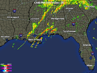
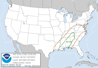
My friends and fellow bloggers Rick and Dewdrop went storm chasing in South Georgia and the Florida Panhandle Friday night. They saw no severe weather but did have quite an adventure. I will not rewrite their accounts, because they both wrote some interesting stuff about their trip. It was exciting to be a part of it, though. Dewdrop's account Rick's account
Team site with stories and radar shots
Storm kills one in Ashburn Albanyherald.com"Residents and emergency workers continued late Sunday to remove fallen trees and secure homes damaged when an EF1 tornado touched down in Ashburn Saturday around 9:20 p.m., officials said. The storm system is connected to the death of one person, a truck driver whose northbound rig was thrown off Interstate 75 in Ashburn into a ditch, Irv Watson, science officer for the National Weather Service, said."

Click on the images below for the Local Storm Report and Public Information Statement from the NWS Talahassee:

Sunday, December 16, 2007

A cold day in Alabama

High 38, Low 29 (currently at 10:09 p.m.)

Saturday, December 15, 2007

At 3:51 this afternoon....


Thursday, December 13, 2007


I took the above photo at about 5 pm today at the intersection of I-65 and AL 157 in northern Cullman County.

It's been an unseasonably warm December week the past few days. Check out these highs at my location:

Monday 76
Tuesday 77
Wednesday 69
Thursday 67
Friday High 59, Low 38

That is all about to change now. The temperature is down to 47 as I write this and it will be much cooler the rest of the week.

Wednesday, December 12, 2007

Records are falling

Monday and Tuesday high temperature records across Alabama were shattered. On Monday 12/10/07 my temperature at Vinemont was 77. All seven official record keeping sites in Alabama set new records for the 10th. These included:

Montgomery 82
Pinson 81
Tuscaloosa 80
Birmingham 79
Anniston 79

An interesting statistic was pointed out by Tim Coleman of Alabamawx.com. He said that there have only been nine days since 1895 that have been warmer during the month of December. That placed Monday in the top 1/4 of one percent of warm December days.

Tuesday, December 11, 2007

Weather headlines

Deadly Midwest ice storm...

Subtropical storm Olga....

December heat wave....today's high will be in the mid to upper 70's in North Alabama...

Models consistently showing snow in Alabama Saturday the 15th and Sunday the 16th...
I am not expecting much more than a changeover to light snow or flurries with little if any accumulation. Check out this excellent post by Tim Coleman.

Alabamawx.com keeps you covered. You can tell I like that site!

I am extremely busy and stressed so I do not have time to post more original stuff at the moment. Have a great Tuesday!

Monday, December 10, 2007


Freezing rain has become a major problem over the Midwest during the past few days. The above map is from the NWS Springfield.

The Tulsa NWS Office put out the following civil emergency message earlier this afternoon:

BULLETIN - EAS ACTIVATION REQUESTED
CIVIL EMERGENCY MESSAGE
RELAYED BY NATIONAL WEATHER SERVICE TULSA OK
247 PM CST MON DEC 10 2007

THE FOLLOWING MESSAGE IS TRANSMITTED AT THE REQUEST OF THE TULSA
AREA EMERGENCY MANAGEMENT AGENCY.

SOME INTERSECTIONS MAY NOT YET HAVE TEMPORARY FOUR WAY STOP SIGNS.

CALL 911 FOR LIFE THREATENING EMERGENCIES ONLY. PLEASE DO NOT HANG
UP IF YOU CALL, YOUR CALL WILL BE ANSWERED.

THE TULSA POLICE DEPARTMENT IS ON OPERATION SLICK STREETS. IF YOU
HAVE A NON INJURY ACCIDENT, DO NOT CALL 911. THE POLICE WILL NOT RESPOND.

ALL HOSPITALS EXCEPT THE OSU MEDICAL CENTER AND HILLCREST MEDICAL
CENTER ARE OPERATING ON BACK UP POWER. AEP-PSO HAS PRIORITIZED
RESTORING POWER TO HOSPITALS FIRST.

IT COULD TAKE SEVERAL DAYS FOR THE POWER TO BE RESTORED TO ALL
HOMES.

DO NOT SEEK SHELTER FROM THE COLD AT AREA HOSPITALS.

SEEK SHELTER AT THE SALVATION ARMY DAY CENTER…102 NORTH
DENVER…THE FIRST BAPTIST CHURCH…403 SOUTH CINCINNATI…THE
COLLINSVILLE FIRST BAPTIST CHURCH…1301 WEST MAIN…THE OLIVETTE
BAPTIST CHURCH IN SAND SPRINGS…155 NORTH 65TH WEST AVENUE…THE
NEW BEGINNINGS BAPTIST CHURCH IN BIXBY…4101 EAST 151ST STREET…THE
FREEDOM BAPTIST CHURCH IN OWASSO…96TH STREET NORTH AND 177TH EAST
AVENUE…AND THE FIRST BAPTIST CHURCH IN SAPULPA…200 SOUTH ELM.

CITIZENS CAN CALL THE MAYORS ACTION LINE AT 596-2100. TO REPORT
DOWNED POWER LINES CALL 888-218-3919.

TO REQUEST TULSA TRANSIT LIFT SERVICE, CALL 625-5722.

Record highs


Above graphic is from the NWS Birmingham and shows the conditions at 11 a.m.

The weather has been nothing short of delightful in North Alabama during the past three days. The boys and I have been busy so opportunities to blog have been few. Today (as of 11 a.m.) it is already up to 75 and 76 in many locations in Alabama.

Friday, December 07, 2007

What next?


Kangaroo farts could fight global warming: scientists ABC News

"Australian scientists are trying to give kangaroo-style stomachs to cattle and sheep in a bid to cut the emission of greenhouse gases blamed for global warming. Thanks to special bacteria in their stomachs, kangaroos' flatulence contains no methane and scientists want to transfer that bacteria to cattle and sheep who emit large quantities of the harmful gas."

Thursday, December 06, 2007

This morning's low...

...was 24.6.

We have virtually no chance of rain for the next three days, at least (Thurs-Sat). Temperatures will be gradually warming and this weekend's weather will be very pleasant; almost springlike.

Wednesday, December 05, 2007

Wisconsin, Minnesota snow / cool and clear here

James Spann posted snow photos from Wisconsin.

The temp this morning was 36.9 here and we are under an unofficial severe clear warning this morning.

---

Updated:

The NWS Duluth has posted snowfall reports from yesterday's winter storm that travelled through their county warning area. Some areas of Iron and Bayfield counties in Northern Wisconsin now have as much as 15" of snow cover. In yesterday's storm alone, the Duluth area received anyehere from 10-17" of new snow. It appeared on radar that a band of heavy snow moved across Lake Superior and then "trained" right over the Duluth area. Look at the radar capture in the previous post.

Articles:

Heavy snow slams Duluth Duluth News Tribune
"But the energy from that clipper also combined with winds off Lake Superior to create a virtual whiteout Tuesday afternoon in Duluth — a lake-enhanced snowstorm that dropped 16.8 inches of new snow on West Duluth by 9:30 p.m.... The unexpected burst of snow Tuesday (only a few inches from the clipper had been forecast for Duluth) combined with Saturday’s storm to leave 20 or more inches of snow on the ground in much of Duluth, the most in early December for more than a decade."

Photos of snow in Duluth Duluth News Tribune

Video from Northlands News Center 3 television
Notice at the end of the video the newscaster said, and I quote, "It sure was a little mess there."

Holy Snow Batman A Duluth blogger describes the snow

Weather webcam from Chicago time lapse video Weatherunderground:

Tuesday, December 04, 2007

More snow from an Alberta Clipper....


Fellow blogger Nathan from Wisconsin is experiencing another bout with snow today. He wrote this afternoon to inform me "The first clipper is cranking up lake-effect snow. Heavy snow here at 13:36. 2 new inches (since 10:30)... up to 8 more possible. thought I'd send you a note, in case you're interested. Want some of this snow?? I don't! - Nathan

Yes....I want the snow!

The low this morning was....

26.2 in my neck of the woods. I had a pretty good frost in the yard. I started to drive off, thinking I had a clear spot on my window but when I turned the heat on iside the vehicle, it fogged the window over, so I had to pull over for a minute. I should have been using some common sense weather knowledge. It was cold, but not as cold as this day last year.

I hope you all have a great day!

Monday, December 03, 2007

Snowfall maps


Thanks to Nathan from Maple Hill Weather in Wisconsin found the above map from the Duluth, Minnesota NWS Offfice.


He also provided links to two ther maps:


NWS Green Bay, WI


Milwaukee NWS

Sunday, December 02, 2007

Wisconsin and Minnesota snow


I highly recommend Nathan's Maple Hill Weather site. Nathan blogs from the extreme northern Wisconsin in Bayfield County. He has some excellent coverage of the winterstorm as it spread across his part of the Upper Midwest this weekend. Thank you to Nathan for sharing the above pictures with me. Go to his site to see more.

Earlier today Nathan told me, "I now have a bit of shoveling ahead of me :) so I need to get cracking. I'll report back with pictures and measurements later, though the main event is over, another inch or two is possible as the low moves away. And then Lake-effect could give us another 1-3 tonight. We need a couple days break... but then a couple of energized clippers will be heading our way Mon and Tue."

The highest snowfall total that he was able to find was 20 inches in Grand Marais, MN, near the Canadian border. The highest total he found in Wisconsin was 13 inches just west of Bayfield, WI. That's about 9 miles northeast of his location.

Duluth NWS storm report

Here is another informative blog from Jayson in Iowa. He provided lots of updates on the icy conditions in his state.

I love a rainy night


I like rain, but with the drought we have been experiencing in North Alabama, I like it even more. As I write this at 8:18 p.m. I am sitting upstairs at my parent's home in Huntsville listening to the rain fall with the window cracked. It is great to listen to the rain fall and the sound of the creek flowing again. The rain has been moderate to heavy during the past half hour or so. The creek that is beside my parent's property is one of the main drainage arteries off Monte Sano. The fact that it is flowing has been very unusual during the past three years and I am enjoying the sound.

Saturday, December 01, 2007

BBQ w/ JBE

I apologize for the poor quality of the above short clip from James Spann's 6 p.m. weathercast last Friday night from the Christmas on the River festival in Demopolis, AL. I have wanted to go to that event for a long time but have not yet had an opportunity to travel way down to the Tombigbee River in Marengo County during this busy season. I hope the guys don't mind me posting this. James and J.B. are notorious for their BBQ eating shenanigans as they travel across the State. It was nice seeing JB make an appearance on TV. I read his writings on Alabamawx.com often, but rarely get to see him. He was the smooth voice of NOAA Weather radios for years until the NWS, in its infinite wisdom, decided to go to a computer generated "voice".

Newer Posts Older Posts Home