Friday, September 22, 2006

Tornadoes in Alabama 9/22/2006


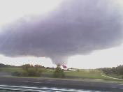
This is a picture of a tornado or funnel cloud that eventually produced F2 damage over Blount County, AL in the Locust Fork community and Oneonta, AL.

This photo was featured on ABC 33/40's severe weather coverage. It was taken by my friend and nephew Justin Berry of Cullman on his cell phone. He was headed up I-65 after work and snapped this photo while the driver was going 90 mph. It was a great shot. He sent it to his mom, who sent it to my phone. I emailed it from my phone to my email account. Then I forwarded it to weatherpix@abc3340.com.

It was the first and best photo that lead meteorologist James Spann received that enabled him to illustrate the dangerous nature of these storms for people living in Blount County.

I am amazed at what technology now enables us to do. Imagine what benefit this would have been in 1974, 1979, 1989, 1994, or 1998 in major Alabama tornadoes!

Thursday, September 21, 2006

Cool Morning

The low this morning in Vinemont was 44.9. It was the coldest morning so far this season.

Sunday, September 10, 2006

Florence is now a hurricane


Florence has become a hurricane out in the Atlantic, but it poses absolutely no threat to the US.

Friday, September 08, 2006

Update From Wake Island

Here is an update from the US Air Force web site regarding the damage to Wake Island in the wake (sorry, I couldn't resist the pun) of Super Typhoon Ioke.

Damage on Wake less than feared, flyover shows

Wednesday, September 06, 2006

Florence

Yesterday Florence officially became a tropical storm. She will pose no threat to the Gulf. We will have to wait and see about the Atlantic coast.

Back to the 50's!

For the first time in quite a while, temperatures are beginning to hit the 50's in the mornings. The lowest reading here at my place in Vinemont, close to the school, was 57. Bring on autumn!

Monday, September 04, 2006

Latest on TD6

TD 6 Forms; Soon to be Florence

Yesterday tropical depression number 6 formed between Africa and the Windward Islands. It is forecast to become Tropical Storm Florence later today and reach hurricane status later this week. It is projected to move to the northwest. It is too early to tell whether it will recurve to the North over the Atlantic or if it will head towards the Bahamas and the US East Coast. It does not appear that it will threaten the Gulf of Mexico.

Friday, September 01, 2006

Typhoon Ioke

USAF Planes to Check Typhoon Damage

Ernesto Reprise

Tropical Storm Ernesto made landfall about 11:30 p.m. EDT near Long Beach, North Carolina.
Newer Posts Older Posts Home