Sunday, December 26, 2010

Alabama's Historic White Christmas!


Huntsville, Alabama


Madison, Alabama


Mooresville, Alabama


I-565


Just north of the Tennessee River


Backwaters of the Tennessee River


Near the Tennessee River


Tennessee River


Decatur, AL


Hartselle, Alabama


North of West Point, Alabama


Vinemont, Alabama


Vinemont, Alabama


Vinemont, Alabama


Vinemont, Alabama


Vinemont, Alabama


Vinemont, Alabama


Monte Sano, Huntsville, Alabama

From the NWS Huntsville:

PUBLIC INFORMATION STATEMENT...AMENDED
NATIONAL WEATHER SERVICE HUNTSVILLE AL
1102 PM CST SUN DEC 26 2010

THE FOLLOWING IS A LIST OF SNOWFALL TOTALS RECEIVED TODAY FROM
OBSERVERS FOR THE CHRISTMAS WEEKEND SNOW EVENT. MINOR ADDITIONAL
ACCUMULATIONS MAY HAVE OCCURRED DURING THE DAY BUT SHOULD NOT
SIGNIFICANTLY IMPACT THE FINAL TOTALS LISTED BELOW.

CITY..................SOURCE........AMOUNT

ALABAMA---------
HUNTSVILLE AIRPORT COOP 4.8
MERIDIANVILLE SPOTTER 4.5
IDER COOP 4.0
PHIL CAMPBELL SPOTTER 4.0
VALLEY HEAD COOP 4.0
ATHENS COCORAHS 3.8
HOLLY TREE COOP 3.8
BOAZ COOP 3.5
HARVEST COCORAHS 3.5
OWENS CROSSROADS COOP 3.5
PAINT ROCK COCORAHS 3.5
WEST POINT COOP 3.5
MOULTON COOP 3.1
HUNTSVILLE NWS OFFICE NWS STAFF 3.0
SCOTTSBORO COOP 3.0
ANDERSON COOP 2.5
PRICEVILLE COOP 2.3
ROGERSVILLE MEDIA 2.0
KILLEN SPOTTER 1.0

TENNESSEE-------
SEWANEE POLICE 7.0*
WINCHESTER COOP 4.2*
HUNTLAND COOP 3.5
LOIS POLICE 3.0
COLDWATER COOP 2.1
BOONSHILL POLICE 1.5

*UPDATED TOTALS RECEIVED AFTER THE PREVIOUS ISSUANCE OF THE
PUBLIC INFORMATION STATEMENT.


THE FOLLOWING REPORTS WERE RECEIVED DURING CHRISTMAS DAY. THESE
TOTALS MAY NOT BE REPRESENTATIVE OF FINAL STORM ACCUMULATIONS
BECAUSE SNOWFALL WAS ONGOING AT THE TIME OF THE REPORT. NO
FURTHER UPDATES WERE RECEIVED FOR THESE LOCATIONS.

CITY..................SOURCE........AMOUNT

ALABAMA---------
HUNTSVILLE-MONTE SANO SPOTTER 6.0
SKYLINE SPOTTER 5.5
PEEKS CORNER EMA 4.0
VINEMONT SPOTTER 4.0
MOULTON 6W PUBLIC 3.5
MADISON NWS STAFF 3.5
FRENCH MILL SPOTTER 3.0
LITTLEVILLE PUBLIC 3.0
RED BAY HAM RADIO 3.0
STEVENSON SPOTTER 3.0
HAMPTON COVE COCORAHS 2.9
FYFFE PUBLIC 2.5
HARTSELLE POLICE 2.5
NEW MARKET 6SW NWS STAFF 2.5
HOLLY POND PUBLIC 2.0

TENNESSEE-------
COWAN POLICE 6.5


$$

CCC/KDW


...

Thursday, December 23, 2010

White Christmas in Alabama?


It is really funny how we get all worked up at the prospect of getting a dusting of snow on Christmas here in Alabama. It seems to be on everyone's mind and in conversations from the water cooler at work all the way to the last minute shoppers at the mall. It's possibly more discussed around here than when the Storm Prediction Center issues a High Risk for severe weather. I guess we Alabamians can be excused, though. Official records in Birmingham, which date back to the late 1800's, reveal that there has never been a true White Christmas (defined by 1" of snow on the ground on Christmas morning). The most snow I remember seeing on Christmas in my lifetime was a dusting on cars and rooftops in Huntsville many years ago.

The system approaching does not appear to be a classic snow-maker for Alabama. Snow in Alabama usually comes in one of three general ways:

1. A cold front moves through and a few flurries or snow showers occur in the cold air after frontal passage in the backwash from the low pressure to our north. This usually results in no accumulation or at most 2" in higher elevations.

2. An upper level low pressure system moves in from the northwest into an existing very cold air mass in place over the state. Usually this results in snow showers that can be briefly heavy. The snow is usually dry and accumulations are usually light (dusting to 1"). Occasionally these systems can tap into enough moisture to surprise a small geographic area with higher accumulations 2-6", but that is very rare.

3. A deep cold air mass is in place over the South while at the same time a low pressure system develops in the Northwest Gulf of Mexico. The cold air has to be deep and well-supported from the north. The low has to be positioned just right, track through the Northern Gulf, and strengthen rapidly. When this scenario phases up just right, Alabama can experience some major snowfall totals. This is the most "ideal" yet rarest scenario for snow in the South. Two examples include Huntsville receiving 21" of snow in 1963 (leading the nation on New Year's Day) and the Blizzard of 1993, which was the textbook example of this scenario. There have been numerous times when I have witnessed 6 or more inches of snow at various places in Alabama and most of them occurred in this kind of set-up. These storms are most likely in January, February, or early March.

Saturday (Christmas Day) will probably most resemble scenario number one. Confidence is high that snowflakes will be in the air in North Alabama on Christmas Day as temperatures will be cold enough to support snow thousands of feet up into the atmosphere and at the surface. Confidence is low that there will be enough moisture to support much, if any accumulation south of the Tennessee River.

No one really knows what will happen, but it is fun to look at the models, sprinkle in a little common sense that comes from many years of watching Alabama weather, and take an educated guess at what might happen. So, a little over 48 hours out, I am predicting a slight chance of very light accumulations roughly north of a line from Hamilton to Anniston. The best chance of light accumulation will be in Northeast Alabama. A dusting is most likely there, but a few of the higher elevations have a slight chance of getting 2 inches.

Bottom line: Snow will fall in North Alabama on Christmas Day, but it will not be significant enough to cause many serious problems. A few communities may be lucky enough to see snow on the ground and may get about as close to a White Christmas as most Alabamians have been in our lifetimes.

...

Wednesday, December 22, 2010

Dreaming of a White Christmas?


GFS


NAM

Snow cover loop (NAM)

A rare "White Christmas" is not out of the question for North Alabama. Stay tuned.

...

Tuesday, December 14, 2010

Snow in NE Alabama / SE Tennessee - 12/12/10


Videos:


...

Cold Morning


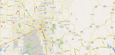
Alabama experienced the coldest air of the season this morning. The map above shows numerous unofficial reports of temperatures between 6 and 9 degrees in Limestone, Madison, and Jackson counties. These were found on the MesoWest site. The coldest low temperature I found was 6.3, reported at the USDA site between Hytop and Skyline in northern Jackson County.

Alabama low temperatures ranged from 6 at Hytop to 24 in Mobile. J.B. Elliott posted his usual excellent list on Alabamawx.com.

...

Tuesday, December 07, 2010

Light Snow in Central/South Alabama?


As illustrated in the above Short Range Ensemble map from the Storm Prediction Center, any precipitation that falls Wednesday in Central or South Alabama is likely to be snow. The blue areas on the map denote a 90 per cent chance that any precipitation that falls will be in the form of snow. That is NOT to say there will be a 90 per cent chance of snow!
As a vigorous shortwave moves toward the Gulf Coast tonight it may be able to squeeze out just enough moisture cause a few snow flurries or light snow showers. The lower levels will be so dry, however, that much of the snow flurry activity could evaporate before reaching the surface.
The best chance of seeing any of this light snow activity will be in southwestern and south central parts of the state in communities such as Demopolis, Thomasville, Selma, Greenville, and Montgomery.
No measurable accumulation is expected.
...

Friday, December 03, 2010

Latest Tornado Count From the NWS


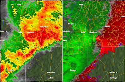
Image from NWS Jackson, MS. 9:45 p.m. base reflectivity (left) and storm relative velocity (right) over Atalla County, MS while storm was producing EF3 damage.

On Monday November 29 and Tuesday November 30, 2010, the Deep South was raked with numerous tornadoes. Survey crews from National Weather Service offices have been out all week surveying the damage. Although most survey activity is complete, there may be a few more tornadoes confirmed before all is said and done.

As of Friday morning December 3, 15 tornadoes have been confirmed in Mississippi and 5 have been confirmed in Alabama. Here is a list of those confirmed thus far.

Alabama:

1:41-1:43 a.m., Millport, Lamar County, EF 1

4:15-4:16 a.m., Scott Station, Perry County, EF1

7:09-7:11 a.m., Blountsville, Blount County, EF1

9:57-10:06 a.m., Prattville, Autauga County, EF1

10:20-10:45 a.m., Dexter/Santuck, Elmore County EF0

Fortunately there were no injuries or fatalities associated with any of these tornadoes. Read more detailed descriptions of survey data at this link from the NWS Birmingham.

Mississippi:

7:27-7:25 p.m., Issaquena/Sharkey Counties, EF0

7:46-8:00 p.m., Yazoo County, EF2

8:04-8:06 p.m., Warren County, EF0

8:07-8:10 p.m., Yazoo County, EF2

8:30-8:30 p.m., Claiborne County, EF0

9:09-9:18 p.m., Hinds County, EF0

9:25-9:26 p.m., Claiborne County, EF1

9:38-9:50 p.m., Leake/Attala Counties, EF3 (6 injured)

11:08-11:09 p.m., Oktibbeha County, EF2 (15 injured)

11:26-11:29 p.m., Clay County, EF1

11:52-11:52 p.m., Monroe County, EF2 (11 injured) - NWS Memphis

2:43-2:58 a.m., Smith County, EF2

2:59 a.m., Amite County, MS, EF0 - NWS New Orleans

5:50-5:58 p.m., Jones County, EF0

7:40 a.m., Hancock County, Waterspout - NWS New Orleans


More can be read about the Mississippi tornadoes here and here.

Article by Johnny Kelley

...

Thursday, December 02, 2010

Sunset Pictures This Week


Tuscaloosa, Alabama 11/27/10


Tuscaloosa, Alabama 11/27/10


Tuscaloosa, Alabama 11/27/10


Morgan County, south of Falkville, AL 12/2/10


Morgan County, south of Falkville, AL 12/2/10

...
Newer Posts Older Posts Home