Saturday, March 24, 2007

Into the 80's

We have hit the 80 degree mark for the first time in 2007 in North Alabama. Yesterday, Friday 3/23/07 Vinemont reached 80.8. Today, 3/24/07, we hit 84.7.

Wednesday, March 21, 2007

Update on 3/1/07 Tornadoes to EF4 Status!

Refer to Alabamawx.com

Enterprise Tornado Now Rated EF4

Here is an exerpt from this post and a summary from the NWS Talahassee.

I figured this would happen at some point… both Brian Peters and I believed the Enterprise tornado to be an EF4, and now the NWS is on the bandwagon… this is the updated statement from NWS Tallahassee:

…TORNADO NUMBER 1…COFFEE COUNTY ALABAMA…ENTERPRISE…THIS TORNADO TOUCHED DOWN AT 108 PM CST JUST SOUTHWEST OF ENTERPRISE. THE TORNADO TRACKED THROUGH ENTERPRISE HITTING THE HIGH SCHOOL AROUND 112 PM CST. THE TORNADO MOVED OUT OF THE TOWN OF ENTERPRISE AND LIFTED BEFORE REACHING DALE COUNTY AT 118 PM CST. THE APPROXIMATE PATH LENGTH OF THIS TORNADO WAS 7 MILES WITH A MAXIMUM DAMAGE WIDTH OF 300 YARDS. THE FINAL RATING ASSIGNED TO THIS TORNADO IS AN EF-4 WITH MAXIMUM WINDS OF 170 MPH. THE EF-4 DAMAGED AREAS ARE RIGHT AROUND THE HIGH SCHOOL AND SEVERAL HOMES ON DIXIE ROAD TO THE NORTHEAST OF BOLL WEEVIL CIRCLE. AN EF-4 TORNADO HAS WINDS OF 166 TO 200 MPH. 9 FATALITIES WERE REPORTED IN ENTERPRISE WITH 8 OF THESE OCCURRING AT THE HIGH SCHOOL.

---

PUBLIC INFORMATION STATEMENT…UPDATED NATIONAL WEATHER SERVICE MOBILE AL 1250 PM CDT MON MAR 19 2007

UPDATED INTENSITY OF MILLERS FERRY TORNADO…

THE TORNADO THAT STRUCK MILLERS FERRY IN WILCOX COUNTY ALABAMA ON MARCH 1 2007 HAS BEEN UPGRADED TO AN EF-4. THE WIND SPEED ESTIMATES HAVE BEEN UPDATED TO 185 MPH BASED ON THE DESTRUCTION OF AT LEAST TWO WOOD FRAME HOMES.

THE TORNADO FIRST TOUCHED DOWN AROUND 1227 PM CST (MARCH 1ST) AT STATE HIGHWAY 28 NEAR MILLERS FERRY DAM. THE TORNADO THEN TRACKED NORTHEAST ACROSS WILLIAM “BILL” DANNELLY RESERVOIR…MOVING ASHORE ON SAND ISLAND AT SAND ISLAND DRIVE. THIS IS WHERE MOST OF SEVERE DAMAGE OCCURRED…WITH NUMEROUS HOMES DAMAGED OR DESTROYED.

ONE RESIDENT HAD ARRIVED AT HIS HOME TO EAT LUNCH WHEN THE TORNADO HIT AND WAS KILLED WHEN HIS MANUFACTURED HOME WAS DESTROYED. NEIGHBORS NEXT DOOR HAD SOUGHT REFUGE IN AN UNDERGROUND STORM SHELTER OUTSIDE THE HOUSE SECONDS BEFORE THE TORNADO HIT. ALL THEY HEARD WAS DEBRIS HITTING THE DOOR OF THE SHELTER. WHEN THEY EMERGED THEY SAW THAT THEIR HOME WAS DESTROYED. THERE WERE ALSO TWO REPORTED INJURIES. MOST OF THE HOMES ARE VACATION HOMES WITH PART-TIME RESIDENTS. IF THE TORNADO HAD STRUCK ON THE WEEKEND WHEN MORE PEOPLE WERE PRESENT…THE LOSS OF LIFE WOULD LIKELY HAD BEEN GREATER.

IN ALL AROUND 40 HOMES WERE DESTROYED OR DAMAGED ON SAND ISLAND DRIVE…WITH SOME OF THE DEBRIS SCATTERED UP TO TWO MILES DOWNSTREAM. THE TORNADO THEN CONTINUED MOVING QUICKLY TO THE NORTHEAST THROUGH SPARSELY POPULATED TERRITORIES.

THE HIGHEST WIND SPEED OF THE TORNADO WAS ESTIMATED AT 185 MPH… WHICH RATES IT AS AN EF-4 ON THE NEW ENHANCED FUJITA SCALE. THE LENGTH OF THE TRACK WAS 15.6 MILES LONG…WITH THE WIDEST WIDTH OF ABOUT 500 YARDS.

Monday, March 19, 2007

Enterprise Tornado Videos


Enterprise, Alabama High School Tornado

Tuesday, March 06, 2007

Enterprise Tornado

What a tragic day it was, six days ago, March 1, 2007. Who wouldn't shed a tear seeing the faces of those high school students and listening to their friends pour out their hearts on the news after the funerals of their friends? Who wouldn't feel a wave of joy at the spirit of unity and community that the people of Alabama and especially Coffee County have shown?

There is an informative, emotional, and enlightening netcast about the situation in Enterprise this week on WeatherBrains. Thanks to meteorolgist James Spann for mentioning my point that this was the first time in 16 years that a tornado caused fatalities in a school in the United States. I hope that this tragedy does not cause people to believe that schools should routinely let out early durning stormy days because it is not the best option.

Below are photos of the damage shared with me by the Director of the Coffee County DHR. Further down are some radar images shared with me by my friends at Alabamaweather.org.


Sunday, March 04, 2007

Thursday March 1, 2007 Tornadoes - Part Two

Post Updated 3/7/07


PUBLIC INFORMATION STATEMENT...UPDATED
NATIONAL WEATHER SERVICE BIRMINGHAM AL
615 AM CST SUN MAR 4 2007


...NWS STORM SURVEYS FOR MARCH 1ST TORNADO OUTBREAK CONTINUES...

TEAMS FROM THE NATIONAL WEATHER SERVICE OFFICE IN CALERA ARE STILL CONDUCTING GROUND AND AERIAL SURVEYS OF THE DAMAGE. THIS PRODUCT WILL CONTINUE TO BE UPDATED AS MORE INFORMATION BECOMES AVAILABLE.

BEGINING IN THE EARLY MORNING HOURS OF MARCH 1, AND CONTINUING WELL INTO THE EVENING HOURS, THE NATIONAL WEATHER SERVICE IN BIRMINGHAM, ALABAMA ISSUED A TOTAL OF 95 WARNINGS CONSISTING OF SIX FLASH FLOOD WARNINGS, 38 SEVERE THUNDERSTORM WARNINGS, AND 51 TORNADO WARNINGS. IN ADDITION TO THESE WARNINGS...APPROXIMATELY 98 FOLLOW UP STATEMENTS WERE ISSUED BETWEEN 515 AM AND 1045 PM.

MINOR FLOODING WAS REPORTED IN BOTH MONTGOMERY AND TUSCALOOSA COUNTIES AND RESULTED IN SEVERAL ROAD CLOSURES. THREE INCHES OF RAINFALL WAS MEASURED IN MONTGOMERY COUNTY.

NON-TORNADIC WIND WAS BLAMED FOR DAMAGE IN ETOWAH, RUSSELL, TALLADEGA, TUSCALOOSA, SUMTER AND MONTGOMERY COUNTIES. A WIND GUST WAS ESTIMATED BY A TRAINED STORM SPOTTER IN THE SPRING VALLEY AREA OF MONTGOMERY COUNTY TO BE BETWEEN 60 AND 65 MPH.

HAIL WAS ALSO ABUNDANT WITH NUMEROUS REPORTS OF 1 INCH AND SMALLER STONES ACROSS MUCH OF CENTRAL ALABAMA. THE LARGEST HAILSTONES REPORTED WERE 5 MILES NORTHEAST OF BESSEMER IN JEFFERSON COUNTY AND WERE APPROXIMATELY THE SIZE OF GOLFBALLS.

THE NATIONAL WEATHER SERVICE OFFICE IN BIRMINGHAM RECEIVED NINE REPORTS OF FUNNEL CLOUDS FROM VARIOUS SOURCES ACROSS THE STATE.

TORNADO FINDINGS THUS FAR:

FAYETTE COUNTY (RATED AN EF0): A TORNADO TOUCHED DOWN 4 MILES NORTHEAST OF FAYETTE NEAR THE INTERSECTION OF COUNTY ROADS 18 AND 107. THE TORNADO TRACKED ABOUT ONE-QUARTER MILE AND WAS 50 YARDS AT ITS WIDEST POINT. THE MAXIMUM SUSTAINED WINDS WERE ESTIMATED AT 65 MPH. NUMEROUS TREES DOWN AND 3 HOMES WITH SHINGLE DAMAGE. A TORNADO WARNING WAS IN EFFECT FROM 248 PM CST VALID UNTIL 315 PM CST.

FAYETTE COUNTY (RATED AN EF1): A TORNADO TOUCHED DOWN 4 MILES NORTHEAST OF HUBBERTVILLE NEAR COUNTY ROAD 43. THE TORNADO TRACK WAS 2.2 MILES LONG AND 150 YARDS AT ITS WIDEST POINT. THE MAXIMUM SUSTAINED WINDS WERE ESTIMATED AT 90 MPH. NUMEROUS TREES WERE BLOWN DOWN AND SNAPPED. THE TORNADO TOUCHED DOWN AT 310 PM CST. A TORNADO WARNING WAS IN EFFECT FROM 248 PM CST VALID UNTIL 315 PM CST.

[Fayette County - Photos of Damage and Map of Damage Path from NWS Birmingham]

WINSTON/CULLMAN COUNTY (RATED AN EF2): A TORNADO TOUCHED DOWN IN THE ARLEY COMMUNITY. THE TORNADO TRACK WAS 6.2 MILES LONG AND 100 YARDS WIDE AT ITS WIDEST POINT. MAXIMUM SUSTAINED WINDS WERE ESTIMATED AT 110-115 MPH. SEVERAL HOUSES AND BARNS WERE DAMAGED. ONE CHICKEN HOUSE WAS COMPLETELY DESTROYED AND TWO OTHERS COLLAPSED. NUMEROUS TREES WERE UPROOTED AND SNAPPED. THE TORNADO TOUCHED DOWN AT 349 PM CST. A SEVERE THUNDERSTORM WARNING WAS IN EFFECT FROM 310 PM VALID UNTIL 345 PM CST. THIS WARNING WAS UPGRADED TO A TORNADO WARNING AT 318 PM CST AND WAS VALID UNTIL 400 PM CST.

[Photos of Cullman/Winston Co Damage, Maps of Damage Path from NWS Birmingham]

TUSCALOOSA COUNTY (RATED AN EF1): AFTER AERIAL SURVEY...IT WAS DECIDED TO COMBINE THE TWO TORNADO EVENTS NEAR SAMANTHA. A TORNADO TOUCHED DOWN TWO MILES NORTHWEST OF SAMANTHA NEAR THE INTERSECTION OF LESUEUR ROAD AND NAZARETH CHURCH ROAD. THE TORNADO TRACK WAS 3.5 MILES LONG AND CROSSED HIGHWAY 43 JUST NORTH OF SAMANTHA. THE TORNADO WAS 100 YARDS WIDE AT ITS WIDEST POINT AND MAXIMUM SUSTAINED WINDS WERE ESTIMATED AT 105 MPH. NUMEROUS TREES UPROOTED AND SNAPPED AND A BRICK HOME LOST A PORTION OF ITS ROOF. SEVERAL TORNADO WARNINGS WERE ISSUED FOR TUSCALOOSA. THE TORNADO THAT CAUSED THIS DAMAGE BEGAN AT APPROXIMATELY 300 PM CST. THE WARNING WAS IN EFFECT FROM 248 PM CST
VALID UNTIL 315 PM CST.

Photos of The Samantha Tornado #1, #2, Blog entry by chaser who took photos

[Tuscaloosa - Photos of damage, map of path, photo of hail, from NWS Birmingham]

JEFFERSON COUNTY (RATED AN EF1): A TORNADO TOUCHED DOWN IN THE ADAMSVILLE COMMUNITY. THE TORNADO STARTED NEAR ABBEY ROAD AND AND TRACKED NORTHEASTWARD. THE TORNADO THEN LIFTED ABOUT 100 YARDS NORTH OF US HIGHWAY 78 NEAR SOLOMON STREET. DOZENS OF TREES WERE EITHER UPROOTED OR SNAPPED. MANY TREES FELL ON HOUSES AND CAUSED SIGNIFICANT DAMAGE. ONE HOME HAD A LARGE PORTION OF ITS ROOF LIFTED OFF. THE TORNADO PATH LENGTH WAS ABOUT 1 MILE LONG AND WAS 300 YARDS WIDE AT ITS WIDEST POINT. THE MAXIMUM WINDS WERE ESTIMATED AROUND 100 MPH. THE TORNADO WAS ON THE GROUND FROM 406 PM CST UNTIL 408 PM CST. A TORNADO WARNING WAS IN EFFECT FROM 313 PM CST VALID UNTIL 415 PM CST.

[Adamsville tornado damage photos from Alabamawx.com]

[Photos of Damage in Jefferson County; Map of damage path from NWS Birmingham]

[Photo of a Funnel Cloud Near Bessemer, AL in Jefferson Co. 4:30]


SHELBY COUNTY (RATED AN EF1): A TORNADO TOUCHED DOWN JUST EAST OF COUNTY ROAD 17...ABOUT 6 MILES SOUTH OF ALABASTER. THE TORNADO TRAVELED EASTWARD FOR ABOUT 3/4 MILE AND WAS 100 YARDS WIDE AT ITS WIDEST POINT. MAXIMUM SUSTAINED WINDS WERE ESTIMATED AROUND 105 MPH. FIFTEEN LARGE PINE TREES WERE SNAPPED OFF ALONG THE PATH. THERE WAS MAJOR ROOF DAMAGE TO ONE HOME AND ROOF DAMAGE TO A BARN. THE TORNADO WAS ON THE GROUND AT 556 PM CST.

[Photos of damage; map of path of Shelby County tornado from NWS Birmingham]
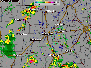
Radar Loop

DALLAS COUNTY (RATED AN EF3): A TORNADO CROSSED THE WILCOX-DALLAS COUNTY LINE ABOUT 6.4 MILES SOUTHEAST OF THE TOWN OF ALBERTA. THE TORNADO TRACKED NORTHEASTWARD AND ENDED ALONG THE ALABAMA RIVER EAST OF THE WHITES BLUFF COMMUNITY. THE MOST CONCENTRATED DAMAGE IN DALLAS COUNTY OCCURRED JUST SOUTH OF FIVE POINTS ALONG COUNTY ROAD 31 AND ALONG COUNTY ROAD 33. TWENTY SEVEN HOMES SUFFERED VARYING DEGREES OF DAMAGE. TWO HOMES WERE COMPLETELY DESTROYED. AT LEAST SIX OUTBUILDINGS WERE DAMAGED. NUMEROUS TREES AND POWER LINES WERE SNAPPED OFF OR UPROOTED ALONG THE PATH. QUARTER SIZE HAIL ALSO OCCURRED WITH THIS STORM AS IT MOVED ACROSS SOUTHERN DALLAS COUNTY. THE TORNADO DAMAGE PATH WAS APPROXIMATELY 15.6 MILES LONG AND 500 YARDS WIDE AT ITS WIDEST POINT. MAXIMUM WINDS WERE ESTIMATED AROUND 142 MPH. ALL OF THIS DATA IS FOR DALLAS COUNTY ONLY. THIS TORNADO STARTED IN WILCOX COUNTY AND WAS THE SAME DEADLY TORNADO THAT AFFECTED THE MILLERS FERRY AREA. THE TORNADO WAS ON THE GROUND IN DALLAS COUNTY FROM 1231 PM CST UNTIL 1248 PM CST. A SEVERE THUNDERSTORM WARNING WAS IN EFFECT FOR DALLAS COUNTY FROM 1207 PM CST VALID UNTIL 1245 PM CST...AND A TORNADO WARNING WAS IN EFFECT FROM 1224 PM CST VALID UNTIL 115 PM CST. THE TORNADO RATING WAS BASED ON THE CONTINUOUS PATH FROM WILCOX COUNTY.

[Wilcox County tornado damage photos from Alabamawx.com]

LOWNDES AND MONTGOMERY COUNTY (RATED AN EF2): A TORNADO TOUCHED DOWN IN FAR SOUTHEASTERN LOWNDES COUNTY...ALONG US HIGHWAY 31 IN THE SANDY RIDGE COMMUNITY. THE TORNADO TRACKED NORTHEASTWARD AND
AFFECTED THE DAVENPORT COMMUNITY...THE FLETA COMMUNITY...AND...SPRAGUE...AND THE RIDGELAND FARM SUBDIVISION. THE TORNADO LIFTED JUST EAST OF US HIGHWAY 231 NEAR THE CARTERS HILL COMMUNITY. SIX MINOR INJURIES WERE REPORTED WITH THE TORNADO. TWO OF THE INJURIES OCCURRED WHEN AN AUTOMOBILE WAS THROWN OFF THE ROAD OVER 300 FEET. AT LEAST 39 HOMES SUFFERED VARYING DEGREES OF DAMAGE. THREE OF THE HOMES WERE COMPLETELY DESTROYED. AT LEAST 23 OUT-BUILDINGS OR BARNS WERE DAMAGED. FOUR LARGE CHICKEN HOUSES WERE COMPLETELY OBLITERATED NEAR THE DAVENPORT COMMUNITY. ONE HIGH VOLTAGE POWER TRANSMISSION LINE WAS TOTALLY DESTROYED. FOURTEEN GRAIN SILOS WERE DESTROYED AND FOUR OF THE SILOS WERE PICKED UP AND THROWN UP TO 1/2 OF A MILE. AT LEAST 10 AUTOMOBILES WERE SIGNIFICANTLY DAMAGED. HUNDREDS OF TREES WERE SNAPPED OFF OR UPROOTED ALONG THE DAMAGE PATH. THE DAMAGE PATH WAS 26.8 MILES LONG AND 600 YARDS WIDE AT ITS WIDEST POINT. MAXIMUM SUSTAINED WINDS WERE ESTIMATED AT 135 MPH. THE TORNADO WAS ON THE GROUND FROM 248 PM CST UNTIL 326 PM CST. A TORNADO WARNING WAS IN EFFECT FOR LOWNDES COUNTY FROM 220 PM CST VALID UNTIL 300 PM CST. A TORNADO WARNING WAS IN EFFECT FOR MONTGOMERY COUNTY FROM 211 PM CST VALID UNTIL 345 PM CST.

[Damage photos and map of path of Lowndes/Montgomery tornado from NWS BHM]

Update from NWS Birmingham 3/5/07:
Russell-Lee-Muscogee County Tornado - March 1, 2007 - F-2
Emergency Management Officials surveyed storm damage in the Phenix City area. It has been determined that the damage was the result of a tornado. The tornado has been rated an EF-2 on the Enhanced Fujita Scale. This rating was based on the highest damage along the entire path through Georgia. The damage in Russell County is consistent with EF0 damage and the damage in Lee County is consistent with EF1 damage.

The tornado touched down near the Russell-Lee County line in Phenix City. Damage near the touchdown point was very light with only minor tree damage being reported. As the tornado tracked northeastward, it became stronger as it approached Lake Oliver on the Chattahoochee River. The greatest damage was from Summerville Road into the River Oak and Rock Island areas. Numerous pine trees were snapped off and some hardwoods were uprooted. Several homes suffered shingle damage. Some of the fallen trees landed on homes and produced moderate damage. The tornado continued eastward where it produced damage in Columbus Georgia. The total tornado damage path was 10.3 miles long and was 300 yards wide at its widest point. The damage path in Alabama was only 2.4 miles. The tornado was on the ground in Alabama from 527 PM CST until 531 PM CST. All of central Alabama was outlooked for a High Risk of Severe Thunderstorms including the chance of violent tornadoes. A Tornado Watch was valid from 945 AM CST until 8 PM CST. See the report from the National Weather Service Office in Atlanta.

Click on the images below for larger picture. The National Weather Service would like to thank the Russell County Emergency Management Agency for providing support during the storm survey process.

[Map of damage path, photos of damage from NWS Birmingham for Russell and Lee Counties]

- - - - - - -

PUBLIC INFORMATION STATEMENT
NATIONAL WEATHER SERVICE MOBILE AL
740 PM CDT FRI MAR 2 2007

...STORM SURVEY RESULTS ACROSS NORTHERN WILCOX COUNTY INDICATES THAT
A LONG TRACKED EF-3 TORNADO MOVED THROUGH THE MILLERS FERRY AREA...

THE TORNADO FIRST TOUCHED DOWN AROUND 1230 PM CST (MARCH 1ST) AT STATE HIGHWAY 28 NEAR MILLERS FERRY DAM. THE TORNADO THEN TRACKED NORTHEAST ACROSS WILLIAM "BILL" DANNELLY RESERVOIR...MOVING ASHORE ON SAND ISLAND AT SAND ISLAND DRIVE. THIS IS WHERE MOST OF SEVERE DAMAGE OCCURRED...WITH NUMEROUS HOMES DAMAGED OR DESTROYED.

ONE RESIDENT HAD ARRIVED AT HIS HOME TO EAT LUNCH WHEN THE TORNADO HIT AND WAS KILLED WHEN HIS MANUFACTURED HOME WAS DESTROYED. NEIGHBORS NEXT DOOR HAD SOUGHT REFUGE IN AN UNDERGROUND STORM SHELTER OUTSIDE THE HOUSE SECONDS BEFORE THE TORNADO HIT. ALL THEY HEARD WAS DEBRIS HITTING THE DOOR OF THE SHELTER. WHEN THEY EMERGED THEY SAW THAT THEIR HOME WAS DESTROYED. THERE WERE ALSO TWO REPORTED INJURIES. MOST OF THE HOMES ARE VACATION HOMES WITH PART-TIME RESIDENTS. IF THE TORNADO HAD STRUCK ON THE WEEKEND WHEN MORE PEOPLE ARE PRESENT...THE LOSS OF LIFE WOULD LIKELY HAD BEEN GREATER.

IN ALL AROUND 40 HOMES WERE DESTROYED OR DAMAGED ON SAND ISLAND DRIVE...WITH SOME OF THE DEBRIS SCATTERED UP TO TWO MILES DOWNSTREAM. THE TORNADO THEN CONTINUED MOVING QUICKLY TO THE NORTHEAST THROUGH SPARSELY POPULATED TERRITORIES.

THE HIGHEST WIND SPEED OF THE TORNADO WAS ESTIMATED AT 142 MPH...
WHICH RATES IT AS AN EF-3 ON THE NEW ENHANCED FUJITA SCALE. THE LENGTH OF THE TRACK WAS 15.6 MILES LONG...WITH THE WIDEST WIDTH OF ABOUT 500 YARDS.

GB/JP

[Map depicting track of Millers Ferry Tornado from NWS Mobile]

[Millers Ferry Tornado Damage Photos from NWS Mobile]

[Miller's Ferry tornado damage photos from Wilcoxwebworks.com]


[KBMX Reflectivity Loop, from NWS Mobile]

[KBMX Storm Relative Motion Loop, from NWS Mobile]

- - - - - -

Enterprise/Coffee, Dale, and Henry County Tornado Report by National Weather Service Talahassee:

Beginning midday Thursday, March 1, and continuing into the early morning hours of Friday, March 2, 2007, the NWS Weather Forecast Office in Tallahassee issued 57 warnings. These included 35 tornado, 19 severe thunderstorm, and 4 special marine warnings. During this time, warnings were issued for two deadly tornadoes, which caused the loss of 15 lives, nine in Enterprise, AL, and six just north of Newton, GA. Figure 1 shows the extent of the severe weather during the event. Preliminary tornado tracks are indicated with charcoal gray ovals. Straight-line wind damage reports occurred within the white rectangles. Following the image is a preliminary assessment of the two deadly tornadoes, and other severe weather that occurred during the event.

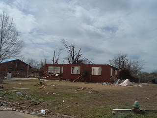
The deadliest tornado was also the first. A tornado warning was issued by this office at 1847 UTC (12:47 PM CST) for Coffee County including the City of Enterprise, AL. An NWS Storm Survey Team determined that a tornado rated EF3 on the new enhanced Fujita Scale touched down in Enterprise, AL, 18 minutes later at around 1905 UTC (1:05 PM CST). The tornado was first observed on the ground at the Enterprise Municipal Airport. About five minutes after that after briefly lifting, it slammed into the Enterprise High School killing eight students and injuring at least 50. The fatalities occurred when a concrete wall collapsed onto a group of students huddled in the hallway in a crouched position. The football stadium was completely destroyed. There was some debate in the media as to whether the students should have been evacuated before the tornado hit. A look in the parking lot, where several cars had been tossed around, indicates that releasing the students could have been even more disastrous. Figure 2 shows the damage paths of the tornado across Enterprise. Figure 3 shows some of the damage to the high school, courtesy of WTVY-4.

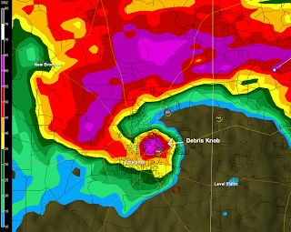
Downtown Enterprise was also hit hard with damage to homes on several streets and many roads blocked by downed power lines. An additional fatality occurred. The tornado path was approximately 200 yards wide and 10 miles long. Figures 4 and 5 show the base reflectivity and storm-relative velocity from the Fort Rucker Doppler radar (KEOX) at the time the twister reached the high school. In the reflectivity image, note the blob of high reflectivity just east of the "hook" likely caused by debris.

The supercell that produced the Enterprise tornado sped northeast across Dale Co dropping golf ball size hail in Ozark and quarter size hail in Newton, AL. A tornado briefly dropped back to the ground in Level Plains, AL, near CR 1 at around 1925 UTC (1:25 PM CST). This same parent supercell spawned another tornado in northeastern Dale County at Echo around 1950 UTC (1:50 PM CST). A total of 15 homes were damaged or destroyed and four people sustained minor injuries in Echo. The tornado then moved into Henry Co, AL, causing damage around 2005 UTC (2:05 PM CST). Several homes were damaged west and southwest of Abbeville. A tractor trailer was overturned northwest of Abbeville. The tornadic supercell continued on into Georgia, causing more damage in Clay County near and north of Fort Gaines around 2030 UTC (3:30 PM EST) before moving north of the our county warning area of responsibility. Figure 6 shows the approximate damage path of the tornado as it crossed Dale and Henry Counties. Storm surveys have not been completed in this area. It is unknown whether this tornado was on the ground for the entire distance indicated, or whether it hopped along this path. Click here for a loop of radar imagery and warning area polygons as this supercell crossed Southeast Alabama. At about the time this storm exited the area, a series of four supercells can be seen lined up from South Central Alabama east to West Central Georgia as shown in Figure 7 below.

[The base storm-relative velocity image from the Ft. Rucker, AL, Doppler Radar (KEOX) for 1915 UTC 1 March 2007.]

[The base reflectivity image from the Ft. Rucker, AL, Doppler Radar (KEOX) for 1915 UTC 1 March 2007. ]

[Enterprise Damage Track, from the NWS Talahassee]

[Photos of Enterprise, AL Tornado Damage]

[Shots Of Enterprise Tornado]

[Another Image Of The Enterprise Tornado, Alabamawx.com]


Saturday, March 03, 2007

Thursday March 1, 2007 Tornadoes - Part One

Alabama residents who pay attention to news and weather had been hearing for days about the possibility of severe weather on Thursday March 1, 2007. During the morning hours of Wednesday February 28, 2007, the Storm Prediction Center placed a large area of the country, including all of Alabama, under a moderate risk of severe weather. They also mentioned the possibility that the risk could be upgraded to "high" for parts of Alabama and Mississippi the next morning.

Just after midnight in the early morning hours of Thursday, the SPC placed virtually all of Alabama and eastern Mississippi under a rare high risk of severe weather. Generally forecasters were saying that the morning would begin with non-severe storms, associated with a warm front. Conditions for severe weather were projected to be in the 11 a.m. to 6 p.m. time frame depending on which part of the state you were in.

Dew points had been rising through the 40's overnight. Scattered storms developed in Alabama around daybreak. These storms produced several reports of small hail, but wind fields were not yet favorable to cause the storms to rotate. As the Birmingham NWS described them, these storms were a "nuisance" compared to what was expected during the afternoon.

For a couple of weeks computer weather forecasting models had been projecting a powerful low pressure system to trek from northern Texas to Iowa. This low was forecast to drag a cold front through the Midwest and South. Ahead of the cold front, a warm front would serve to replace the cool dry airmass with a warmer, moister airmass. Temperatures were forecast to be around 70 with dewpoints over 60 throughout the state and over 65 in the southern half of the state. Above all of these surface features was a stong jet stream out of the southwest. Surface winds at the same time were expected to be stong out of the south.

All of the parameters were in place for an outbreak of tornadoes, including a couple of violent tornadoes. And that is what was forecasted.

Friday, March 02, 2007

Should Have School Officials Closed Enterprise, Alabama HS 3/1/07?

Before answering the question, let us consider the following information:

I. Most tornado fatalities occur in mobile homes.

Between 1985 and 2003, according to NOAA, there were a total of 1007 tornado-related fatalities in the U.S.

40 % were in mobile homes
31 % were in site-built homes
9.7 % were in vehicles
5.8 % were in churches or schools
5.3 % were outdoors
3.5 % were in businesses
4.7 % were classified as "other"

Note that although 40% of deaths were in mobile homes and 31% were in site-built homes, only 16.3 percent of residences in Alabama were mobile homes according to the U.S. Census Bureau in the year 2000.

This data suggests that 56% of people who died in their residences lived in mobile homes, while only 16.3% of the total population lived in mobile homes. The percentage of residences in Coffee County that were mobile homes was 16.4 according to city-data.com.

II. Incidents of tornado fatalities in schools are relatively rare compared to other locations.

Prior to 2007, the most recent tornado-related fatality in a school was over 16 years ago in the Plainfield, IL tornado on August 28, 1990. The Plainfield tornado killed two people at 3:30 p.m., including a science teacher who was preparing the next day’s lesson. A secretary was killed at the Plainfield District Administration building. Three other lives were lost in Plainfield at Mary Immaculate Church and School. Of the 28 fatalities in Plainfield, "seven persons died in one large apartment complex; eight, in vehicles; five, in schools; four, in houses; and two, outside. Three persons died at one high school, where greater than or equal to 10 students crouched against the only hallway wall that did not collapse and, therefore, may have been protected from fatal or severe injury," according to the CDC.

Prior to 2007, other Alabama tornadoes that caused fatalities in schools include:

March 6, 1944 - Horton, Alabama - 3:00 p.m. (1 fatality)
March 22, 1929 - Merrellton, Alabama - 11:00 a.m. (5 fatalities)
December 7, 1927 - Tunnel Springs, Alabama – 11:30 a.m. (1 fatality)
January 11, 1918 - Dothan-Cowarts, Alabama – 1:40 p.m. (8 fatalities)
February 23, 1917 - Hollins, Alabama - 3:30 p.m. (2 fatalities)
January 3, 1906 - Josie-Banks, Alabama - 11:30 a.m. (2 fatalities)
February 19, 1884 - Goshen, Alabama - 2:30 p.m. (1 fatality)

According to famed tornado historian and researcher Thomas Grazulis with the Tornado Project, the worst tornado tragedies in schools prior to the Enterprise Tornado were as follows:

Date / City, State / Rating / Number of Deaths
Mar 18, 1925 Desoto, IL F5 - 33
Mar 18, 1925 2:00 PM
Murphysboro, IL F5 - 25
Feb 1, 1955 2:20 PM Commerce Landing, MS F3 - 17
Jan 4, 1917 11:00 AM Vireton, OK F3 - 16
Nov 9, 1926 2:23 PM La Plata, MD F3 - 14
Apr 21, 1967 3:50 PM
Belvidere, IL F4 - 13
May 2, 1929 12:55 PM Rye Cove, VA F2 - 13
Mar 22, 1897 8:30 AM Arlington, GA F2 - 8
Jan 11, 1918 1:40 PM Dothan, AL F3 - 8
Jun 20, 1890 2:30 PM Paw Paw, IL F4 – 7


Nationwide, between 1884 and 2007, a total of 45 tornadoes caused 282 fatalities in schools according to Wikipedia. Even though this represents a lot of precious lives, it represents a very low percentage of the total number of tornado-related deaths during that time.

III. Another consideration is the fact that 96% of all tornado deaths occur in strong to violent tornadoes (F2 or greater).

Only 26% of all tornadoes reach F2 or greater strength and these tornadoes account for the vast majority of fatalities (96%). This information is available through NOAA and the Tornado Project. Because of this fact, the lowest level, interior sections of secure buildings, away from windows are generally safe in all but the very worst tornadoes. However, mobile homes can be pushed off foundations or overturned and automobiles can be blown off the road even in an F1 tornado.

Conclusions

The Enterprise school administrators planned on closing Enterprise High School early at 1 p.m. but at the last minute decided not to close the school because the area was under a tornado warning. Despite the fact that 8 students lost their lives, I think that school administrators made the best possible decision. If school had been dismissed early, many students would have been in cars, busses, on foot, in mobile homes, and unaccounted for by parents. As a result, many of them would have been in a much more vulnerable position than they were at the school.

Statistics and history seem to indicate that, generally speaking, children tend to be safer in school during severe weather. Almost all deaths that occur in schools during tornadoes are in F3 or greater tornadoes. If children are released early, they will be more susceptible to danger from weaker tornadoes, (which are much more frequent), because they will be caught in cars, busses, and mobile homes. Not even all site-built homes are as safe as schools.

Perhaps the most disturbing trend is the idea of school administrators deciding during the early morning hours to release children at 11, 12, or 1:00. When those decisions are made in the early morning hours, no one, including meteorologists, can pinpoint the exact time and place the dangerous weather will arrive. Allowing for travel time, parents and students may have been on the road between the hours of 10 a.m. and 2 p.m. throughout Alabama on Thursday. If a tornado happens to strike during that time, those travelers are especially vulnerable. If there is a moderate to high risk of severe weather and an administrator deems it necessary to close a school, he or she should either call off school completely or keep the students in school all day. It was insane that schools were closing during the peak of the severe weather.

Schools should have a very liberal policy of allowing parents to make the final decision. As a parent, the ultimate responsibility for my child’s safety is mine, not the government’s. In order to enhance school safety, I think that consideration should be given to installing "safe rooms" or "storm shelters" in all schools in tornado-prone areas that do not currently have adequate shelter.

As we all know, hindsight is 20/20. Obviously almost anywhere would have been safer than Enterprise High School on Thursday March 1, 2007 because it was struck by an EF3 tornado. 99.9% of the geographic area in this state would have been safer than the hallway of that school. It’s too easy for critics to say "they should have let the students out of school." But, based on what was known at the time, the administrators made the right decision.

What Others Are Saying (Updated 3/5/07)

But senior Charles Strickland said the carnage would have been far worse if students were trying to leave school during the storm. "If they'd let us out, they'd be looking at 50 to 300 dead," Strickland said. He pointed to a parking lot full of students' vehicles that were thrown around by the twister, with some coming to rest against the building. "Imagine those kids in the parking lot sitting in those cars," English teacher Beverly Thompson said. This was from an AP article by Jay Reeves.

"The administration of Enterprise High School did the right thing by keeping students in the school building during the March 1 tornado. I applaud their plan, which probably saved the lives of dozens of students. Yes, we mourn the loss of the precious lives that were lost, but we can’t let that distort the school closing issue. I truly regret that our friends in Enterprise are having to deal with the countless array of national TV “talking heads” who are playing Monday Morning Quarterback, and being critical of their decision not to dismiss school. All of these people have basically no understanding of tornadoes, severe thunderstorms, the tornado warning process, Alabama weather history, and engineering methods in home and school design and construction. It is all noise, and I know the people in Southeast Alabama will be glad when those people leave town." James Spann, in Alabamawx.com

"Some lined up to hug and offer words of encouragement for the school superintendent. First Baptist Church parishioners gave Superintendent Jim Reese a standing ovation after the pastor thanked him for his service to the community." AP Article on WTVY web site.

"Mike Shroades entered Enterprise High School to pick up his daughter Thursday afternoon. School was closing at 1 p.m. and he hoped to make it home before the storm struck. He didn’t make it. Shroades walked into the school just as police officers ran inside yelling “it’s coming.” Parents, teachers and students took shelter in the hallway in the middle of the school. Debris was everywhere. People were screaming. You could feel your body moving from the wind and suction,” he said. His daughter, Brooke Shroades, was across the school, huddled inside a cubby hole in the choir room. “When I heard the train sound, I started screaming,” she said." Tornado Witness by Whitney McHugh of the Dothan Eagle

"What the school did is exactly what I would have done if I had been here," Riley said. "There are certain things that will cost lives that we cannot control." "Riley tours Enterprise High, says officials made right decision on closing at 1 p.m." by the Birmingham News

Thursday, March 01, 2007

More Warnings and Reports

2:19 Tornado Warning - Barbour

2:20 Tornado Warning - Lowndes

2:23 Tornado Warning - Montgomery, Pike

2:26 Tornado Warning - Pickens

2:30 Tornado Warning - Barbour

2:38 Radar evidence of circulation west of Vernon in Lamar County

2:40 Tornado Warning - Lamar

2:41 SPC Mesoscale Discussion:
THREAT FOR TORNADOES CONTINUES OVER THE REMAINING 
PARTS OF WW 44 AND 46 WITH GREATEST THREAT FOR
STRONG TORNADOES NEXT FEW HOURS FROM ERN MS
THROUGH NCNTRL...CNTRL AND SRN AL...THE FL
PANHANDLE AND PARTS OF WRN GA.
2:42 Tornado Warning - Greene (northern part of county near Sipsey River)

2:43 Tornado Warning - Bullock

2:43 Wall cloud reported in Vernon in Lamar County

2:45 Tornado Warning - Tuscaloosa

2:49 Tornado Warning - Fayette

2:53 Damage was reported in Lamar County in Vernon by EMA

2:57 Tornado Warning - Barbour

2:59 Tornado Warning - Sumter

3:01 Tornado Warning - Pickens

3:03 Report from Enterprise Hospital on ABC 33/40 - 25 patients, fractures, chest pains, students and teachers treated at hospital, no fatalities reported as of now

3:05 Strong rotation south of Winfield in northern Fayette County, moving towards NW Walker.

3:06 Weaker circulation near Coker in Tuscaloosa, headed toward Northport

3:07 Circulation NE of Samantha in Tuscaloosa Co, approaching Windham Springs and Oakman.

3:08 Circulation SE of Alice ville in Pickens County.

3:10 Tornado Warning - Walker, Winston

3:12 Tornado Warning - Tuscaloosa

3:13 Tornado Warning - Pike, Jeffeson, Walker

3:15 Tornado Warning - Greene

3:16 Funnel Cloud at 3:10 4 miles S. of Winfield

3:16 Wall cloud near toll bridge in Tuscaloosa

3:18 Tornado Warning - Marion, Winston

3:19 Tornado Warning - Bullock

3:20 Wall cloud shown on ABC 33/40 Sky Cam in Tuscaloosa

3:23 Tornado Warning - Barbour, Bullock

3:24 Northport residents reporting rotation posible on ground near 82/43 at Northport Civic Center according to ABC 334/40 skywatcher in Tuscaloosa

3:27 Trees down in Fayette county

3:35
10 Se Hayneville [Lowndes Co, AL] emergency mngr reports FUNNEL CLOUD at 03:05 PM CST -- ema reports touchdown in letohatchee....12 Se Hayneville [Lowndes Co, AL] emergency mngr reports TORNADO at 03:05 PM CST -- touchdown reported in sandy ridge. several houses damaged.

3:36 Tornado Warning - Cullman

3:41
Tornado Warning - Jefferson, Tuscaloosa

3:48
Tornado Warning - Walker

3:50 Golf Ball sized hail and structural damage in Samantha

3:50
Tornado Warning - Pickens

4:09
Tornado Warning - Jefferson

4:14
Tornado Warning - Pickens

4:16
Tornado Warning - Tuscaloosa

4:21 Adamsville -
some people traped in a house on farley road.. also some houses damaged on co rd 52 also one chicken house blowed away ..no injurys tho also power lines down and trees..

4: 23
Carbon Hill [Walker Co, AL] public reports FUNNEL CLOUD at 04:15 PM CST -- public reports a funnel cloud over carbon hill moving toward manchester.

Samantha [Tuscaloosa Co, AL] emergency mngr reports TSTM WND DMG at 03:50 PM CST -- roof destroyed on home. possible tornado dmg.


Northport [Tuscaloosa Co, AL] trained spotter reports FUNNEL CLOUD at 03:50 PM CST -- reported by spotter


Tuscaloosa [Tuscaloosa Co, AL] trained spotter reports HAIL of marble size (E0.50 INCH) at 03:50 PM CST --


Ne Tuscaloosa [Tuscaloosa Co, AL] emergency mngr reports FUNNEL CLOUD at 03:45 PM CST --


Ramer [Montgomery Co, AL] emergency mngr reports TORNADO at 03:35 PM CST -- unconfirmed tornado touchdown


2 N Oak Grove [Talladega Co, AL] amateur radio reports HAIL of nickel size (E0.88 INCH) at 03:35 PM CST --


Montgomery [Montgomery Co, AL] amateur radio reports FLOOD at 03:35 PM CST -- vaughn rd. ditches overflowing.


Fayette [Fayette Co, AL] amateur radio reports TSTM WND DMG at 03:30 PM CST -- co rd 49. workshop destroyed. other structural damage. possible tornado damage

Tuscaloosa [Tuscaloosa Co, AL] fire dept/rescue reports HAIL of quarter size (E1.00 INCH) at 03:30 PM CST -- gena in tuscaloosa co.

2 N Northport [Tuscaloosa Co, AL] amateur radio reports HAIL of marble size (E0.50 INCH) at 03:30 PM CST --


Montgomery [Montgomery Co, AL] amateur radio reports HEAVY RAIN of E3.00 INCH at 03:30 PM CST -- montgomery county measured.


Northport [Tuscaloosa Co, AL] amateur radio reports HAIL of golf ball size (E1.75 INCH) at 03:25 PM CST --

1 Se Graysville [Jefferson Co, AL] law enforcement reports TSTM WND DMG at 04:12 PM CST -- trees and power lines down in the westwood community.

4:24 Tornado Warning - Macon

4:29
Northport [Tuscaloosa Co, AL] emergency mngr reports FLASH FLOOD at 04:28 PM CST -- county road 171 on north side of city flooded and impassable.

Samantha [Tuscaloosa Co, AL] emergency mngr reports HAIL of quarter size (E1.00 INCH) at 03:15 PM CST -- hail w/ trees down


Fayette [Fayette Co, AL] emergency mngr reports TSTM WND DMG at 03:15 PM CST -- roof damage near hwy 107 with trees down. possible tornado damage.

Reports on Fatalities: 9 in Enterprise (8 at the school and 1 elsewhere in town) and one other at Miller's Ferry, on the Alabama River in Wilcox County.

Tornado Warning - Pickens County


The NWS in Birmingham has issued a Tornado Warning for Pickens County in West Alabama at 2:00. There are two strong indications of rotation in a storm that is crossing the Alabama state line.

Conditions are extremely favorable for further development in West Central Alabama.

Tornado Warning for Montgomery at 2:11.

Greene and Sumter Counties are also under tornado warnings as of 2:13.

South Alabama Update

Tornado warnings have been issued for Marengo, Dallas, Clarke, Wilcox, Monroe, Coffee, and Dale during the past few hours.

Damage has been reported in many of these areas. The worst report so far has been out of Coffee County. The high school has sustained significant damage and students are trapped according to TWC.

Other areas receiving damage include:

Miller's Ferry near the Alabama River in Wilcox

Orrville in Dallas County

James Spann of ABC 33/40 reported the following at 1:51: "Enterprise - Coffee Co, AL - A NWS employee reports a tornado at 1:10 p.m. CST with a 1/8 mile wide damage path through Enterprise. Possibly dozens of homes were damaged. Based on radar...tornado went through enterprise at 110pm cst.

Tornado Warning - Marengo


33/40 Pinpoint Doppler

Tornado Warning in Colbert and Lauderdale

AT 1100 AM…SPOTTERS REPORTED DAMAGE TO A HOMENEAR HIGHWAY 20 WEST OF THE NATCHEZ TRACE PARKWAY…AND SPOTTERS ALSO REPORTED A TORNADO TOUCHDOWN IN THIS GENERAL AREA.

Another PDS Tornado Watch


This one has been issued for East Alabama and will last until 9 p.m.

Why are schools letting out early?

My guess is that many school systems fear the potential liability they may have if a tornado strikes a school full of children while we were under a PDS watch and a high risk. Another point is that if an F3 or greater tornado hits a school, hundreds of children are in danger because they are concentrated all in one area instead of being spread out throughout the community.

I only mentioned lawsuits because it is a sad reality of our society. If something goes wrong there will be parents suing, even though they are truly the ones that should be accountable the most.

I have a major problem with the timing of the schools’ closing, though. Schools should have either stayed open all day or closed entirely. My fear is that children will be on the road between 12 and 2 when the weather may get dangerous. I sure hope not.

7 AM Convective Outlook From SPC


Here are a few exerpts...

...MAJOR OUTBREAK OF TORNADOES AND SEVERE THUNDERSTORMS POSSIBLE ACROSS MUCH OF THE CENTRAL AND SOUTHEASTERN UNITED STATES TODAY AND TONIGHT...

VERY LARGE AND POWERFUL UPPER TROUGH IS BECOMING NEGATIVELY TILTED THIS MORNING OVER THE SOUTHERN PLAINS. THIS TROUGH AND ASSOCIATED 100+ KT MID LEVEL JET MAX IS FORECAST TO ROTATE RAPIDLY EASTWARD TODAY INTO THE TN VALLEY. WIDESPREAD EXTREMELY STRONG VERTICAL SHEAR PROFILES...COUPLED WITH RAPIDLY INCREASING LOW LEVEL MOISTURE AND INSTABILITY...INDICATE THE THREAT OF A LARGE OUTBREAK OF TORNADOES AND SEVERE THUNDERSTORMS THIS AFTERNOON AND TONIGHT. SOME OF THE TORNADOES MAY BE STRONG OR VIOLENT.

...MID MS VALLEY... FIRST WAVE OF TORNADIC SUPERCELLS ARE ONGOING THIS MORNING OVER PARTS OF SOUTHERN MO AND NORTHERN AR. THESE STORMS WILL REMAIN CAPABLE OF SIGNIFICANT TORNADOES...AS WELL AS DAMAGING WINDS AND HAIL...FOR SEVERAL MORE HOURS AS THEY TRACK EASTWARD TOWARD THE MS RIVER. SOUTHWARD DEVELOPMENT OF THIS ACTIVITY HAS BEEN SLOW THIS MORNING DUE TO MID LEVEL CAPPING INVERSION. HOWEVER...UPPER TROUGH IS BEGINNING TO OVERSPREAD AREA...AND SEVERE THUNDERSTORMS ARE LIKELY TO INCREASE IN COVERAGE ACROSS PARTS OF EAST TX AND LA BY MID MORNING.

...GULF COAST REGION... PRESENT INDICATIONS ARE THAT SCATTERED THUNDERSTORMS WILL DEVELOP OVER EASTERN LA AND MS BY MID MORNING...AHEAD OF UPPER TROUGH. THIS REGION WILL BE VERY MOIST AND UNSTABLE WITH MLCAPE VALUES OVER 1000 J/KG EXPECTED. VERY IMPRESSIVE VERTICAL SHEAR PROFILES ARE IN PLACE AND WILL ONLY STRENGTHEN THROUGH THE DAY. THIS WILL RESULT IN VERY FAVORABLE CONDITIONS FOR TORNADIC SUPERCELLS CAPABLE OF STRONG/ VIOLENT TORNADOES...LARGE HAIL...AND DAMAGING WINDS. THIS ACTIVITY WILL LIKELY SPREAD EASTWARD ACROSS PARTS OF AL/GA AND INTO NORTHERN FL THROUGH THE AFTERNOON AND EVENING. RAPID MOVEMENT OF UPPER TROUGH...STRENGTH OF WIND FIELDS...AND QUALITY OF RETURNING LOW LEVEL MOISTURE ALL POINT TO THE POTENTIAL FOR AN OUTBREAK OF TORNADOES TODAY.

PDS Tornado Watch


URGENT - IMMEDIATE BROADCAST REQUESTED TORNADO WATCH NUMBER 44 NWS STORM PREDICTION CENTER NORMAN OK 730 AM CST THU MAR 1 2007

THE NWS STORM PREDICTION CENTER HAS ISSUED A TORNADO WATCH FOR PORTIONS OF:

MUCH OF ALABAMA
PARTS OF EASTERN ARKANSAS
WESTERN FLORIDA PANHANDLE
SOUTHEASTERN LOUISIANA
MISSISSIPPI
WESTERN AND MIDDLE TENNESSEE
COASTAL WATERS

EFFECTIVE THIS THURSDAY MORNING AND EVENING FROM 730 AM UNTIL 600 PM CST.

...THIS IS A PARTICULARLY DANGEROUS SITUATION...

DESTRUCTIVE TORNADOES...LARGE HAIL TO 2.5 INCHES IN DIAMETER... THUNDERSTORM WIND GUSTS TO 80 MPH...AND DANGEROUS LIGHTNING ARE POSSIBLE IN THESE AREAS.

THE TORNADO WATCH AREA IS APPROXIMATELY ALONG AND 140 STATUTE MILES EAST AND WEST OF A LINE FROM 5 MILES EAST NORTHEAST OF FORT CAMPBELL KENTUCKY TO 45 MILES SOUTH SOUTHEAST OF NEW ORLEANS LOUISIANA. FOR A COMPLETE DEPICTION OF THE WATCH SEE THE ASSOCIATED WATCH OUTLINE UPDATE (WOUS64 KWNS WOU4).

REMEMBER...A TORNADO WATCH MEANS CONDITIONS ARE FAVORABLE FOR TORNADOES AND SEVERE THUNDERSTORMS IN AND CLOSE TO THE WATCH AREA. PERSONS IN THESE AREAS SHOULD BE ON THE LOOKOUT FOR THREATENING WEATHER CONDITIONS AND LISTEN FOR LATER STATEMENTS AND POSSIBLE WARNINGS.

OTHER WATCH INFORMATION...CONTINUE...WW 40...WW 41...WW 42...WW 43...

DISCUSSION...SCATTERED SEVERE/SUPERCELL THUNDERSTORMS ARE EXPECTED TO INCREASE IN AREAL COVERAGE AND INTENSITY THIS MORNING AHEAD OF POWERFUL UPPER TROUGH. STRONG SOUTHERLY LOW LEVEL WINDS ACROSS WATCH AREA WILL TRANSPORT GULF MOISTURE NORTHWARD. VERY STRONG VERTICAL SHEAR PROFILES AND SUFFICIENT INSTABILITY WILL POSE THE RISK OF STRONG/VIOLENT TORNADOES...AS WELL AS DAMAGING WINDS.

AVIATION...TORNADOES AND A FEW SEVERE THUNDERSTORMS WITH HAIL SURFACE AND ALOFT TO 2.5 INCHES. EXTREME TURBULENCE AND SURFACE WIND GUSTS TO 70 KNOTS. A FEW CUMULONIMBI WITH MAXIMUM TOPS TO 500. MEAN STORM MOTION VECTOR 24045. ...HALES

Mesoscale Discussion from SPC


MESOSCALE DISCUSSION 0234 NWS STORM PREDICTION CENTER NORMAN OK 0654 AM CST THU MAR 01 2007

AREAS AFFECTED...ERN AR ACROSS NRN MS...WRN/MIDDLE TN...NRN AL
CONCERNING...SEVERE POTENTIAL...TORNADO WATCH LIKELY
VALID 011254Z - 011400Z

WIDESPREAD SEVERE WEATHER POTENTIAL TO INCLUDE POSSIBLE LONG-TRACK TORNADOES WILL INCREASE ACROSS THE MS AND TN VALLEYS THROUGH THIS MORNING. TORNADO WATCH COORDINATION ACROSS THESE AREAS WILL COMMENCE SHORTLY.

POWERFUL LARGE SCALE MID/UPPER TROUGH CONTINUES TO MOVE EAST ACROSS THE PLAINS THIS MORNING WITH PRONOUNCED DIFFLUENT FLOW OF OVER 100KT FORECAST TO SPREAD EAST ATOP INCREASINGLY MOIST AND UNSTABLE WARM SECTOR FROM THE NRN GULF COAST NWD ACROSS MS/AL...AND MUCH OF TN. GIVEN SPEED OF THE UPPER SYSTEM AND WIDESPREAD NATURE OF THE INTENSIFYING VERTICAL MOTION...A LARGE PDS WATCH MAY BE NEEDED. STRENGTH OF LOW LEVEL SHEAR AND LOW LFC WILL SUPPORT THE POTENTIAL FOR FAMILIES OF LONG-TRACK SUPERCELL STORMS. TORNADO THREAT...CURRENTLY WELL ESTABLISHED OVER SRN MO...AR...AND LA...WILL SHIFT STEADILY EWD ACROSS THE MS RIVER THROUGH THE MORNING.

..CARBIN.. 03/01/2007

Tornado Watch to Come

By mid morning I expect the SPC to issue a tornado watch for much of Alabama. It will probably be a PDS (particularly dangerous situation) watch.

The line will be approaching west Alabama around noon, but supercells are a good bet ahead of the line.

From Alabamawx.com

This morning on Alabamawx.com, James Spann provided some very important comments about the severe weather threat. He first mentioned the history of "high risk" outlooks for Alabama:

"Here is an interesting note from the Birmingham NWS office:

THE STORM PREDICTION CENTER HAS PLACED MOST OF CENTRAL ALABAMA UNDER
A HIGH RISK OF SEVERE THUNDERSTORMS FOR TODAY. SINCE 1989…PARTS
OF ALABAMA HAVE BEEN UNDER A HIGH RISK ON 10 OCCASIONS:
NOVEMBER 15 1989 (HUNTSVILLE TORNADO)
MARCH 27 1994 (PALM SUNDAY TORNADO OUTBREAK)
NOVEMBER 27 1994
MAY 2 1997
APRIL 8 1998 (OAK GROVE F5 TORNADO)
MAY 5 1999
OCTOBER 13 2001
NOVEMBER 10 2002 (VETERANS DAY TORNADO OUTBREAK)
MAY 5 2003
APRIL 7 2006"

The above was from James' post at the following URL:

http://www.jamesspann.com/wordpress/?p=1070

I wonder what happened on some of those days we didn’t have a huge outbreak. I think on some of them there were bad storms nearby.

I think the best point he made was, “there is no need to fear the weather today, but you do need to use your common sense and be in a position to hear severe weather warnings, and have a plan of action if a tornado warning is issued. It is that simple.”

I also liked what JB pointed out last night. Even in a major outbreak, only a tiny percentage of the area will be affected. If people follow basic safety instructions, maybe we can get through this together.

Let me also add that we should pray for people to be safe and for the Lord to watch over and protect people.

New Report

Thunder, lightning, and heavy rain are occurring at the moment in Huntsville. James Paul Dice of WHNT said that he received a call from a viewer in Vinemont about small hail falling there a few minutes ago.

Discussion from NWS Birmingham

AREA FORECAST DISCUSSION NATIONAL WEATHER SERVICE BIRMINGHAM AL 339 AM CST THU MAR 1 2007

.DISCUSSION... NOT MUCH LEFT BUT THE WAITING...WATCHING...ANALYZING...AND ADJUSTING. THE STAGE IS RAPIDLY BECOMING SET FOR A POTENTIAL VERY HIGH IMPACT SEVERE WEATHER/TORNADO EVENT ACROSS THE AREA. SHOWERS AND THUNDERSTORMS ALREADY BREAKING OUT THIS MORNING ARE A RELATIVE NUISANCE COMPARED TO WHAT COULD DEVELOP LATER TODAY. SEVERE WEATHER OUTLOOKS AND STATEMENTS FROM SPC DESCRIBE THE SCENARIO VERY WELL... AND NO NEED TO REHASH THINGS. EXPECTED TIMING REMAINS BASICALLY UNCHANGED...WITH GREATEST THREAT TIME FROM ABOUT NOON TO 8 PM (WEST TO EAST). NOT TRYING TO NEEDLESSLY HYPE THIS THING AND CREATE A PANIC. BUT ALL FOLKS NEED TO BE AWARE OF THE POTENTIAL FOR STRONG TORNADOES THIS AFTERNOON...AND WILL COUNT ON OUR PARTNERS (MEDIA... EMA...AND OTHERS) TO HELP GET THE WORD OUT.

Discussion From Huntsville NWS

AREA FORECAST DISCUSSION NATIONAL WEATHER SERVICE HUNTSVILLE AL 304 AM CST THU MAR 1 2007

.DISCUSSION... MAIN CONCERNS FOR TODAY WILL BE THE THREAT OF SEVERE WEATHER ACROSS THE AREA. MOST OF CWA IS IN A RARE HIGH RISK AREA FOR THE DAY ONE OUTLOOK. ATTM OUR WRN 3 COUNTIES (LAUDERDALE/COLBERT/FRANKLIN) ARE IN A SEVERE THUNDERSTORM WATCH UNTIL 8 AM. NO SEVERE WEATHER TO REPORT ACROSS THE CWA SO FAR...ONLY PEA TO DIME SIZE HAIL/GUSTY WINDS.

CURRENTLY TEMPS ARE MOSTLY IN THE LOWER 60S WITH DEWPOINT RANGING FROM THE LOWER 40S IN NWRN AL TO MID 30S IN NERN AL. LOOKS LIKE THE BEST CHANCE OF SEVERE WX WILL BE MID MRNG THRU EARLY EVENING HOURS ACROSS THE CWA.

THIS AFTN...WITH 8H WINDS ARND 50 KTS/TEMPS IN THE LOWER 70S/DEWPOINTS IN THE MID 50S/HELICITIES 500 TO 600...SEVERE WX LOOKS TO BE A SURE BET. ALSO THINKING MIGHT SEE ENOUGH SUN BY AFTN TO ADD MORE ENERGY TO THE SITUATION. ATTM WILL GO LOWER 70S TODAY BUT IF WE GET MORE SUN THAN EXPECTED COULD SEE MID 70S..SINCE WE ARE ALREADY IN THE LOWER 60S. WILL NOT ISSUE ANY LAKE WIND ADVISORY FOR TODAY DUE TO THE HIGH RISK OUTLOOK OVER OUR CWA...WE WILL HAVE BIGGER FISH TO FRY.

LOOKS LIKE BY 9 TO 10 PM IN EXTREME NERN AL...THE SEVERE THREAT WILL BE OVER AS CDFNT PUSHES THROUGH. EXPECTING CLEARING SKIES OVERNIGHT WHICH SHOULD LET TEMPS FALL INTO THE UPPER 30S/LOW 40S. OTHERWISE AFTER TONIGHT...LOOKS LIKE COOLER WX THRU THE WEEKEND. REMOVED THE SLIGHT CHANCE OF RAIN ON SATURDAY SINCE GFS/NAM LOOK TO DRY AS WEAK CDFNT SLIDES ACROSS THE AREA. MONDAY THRU WEDNESDAY TEMPS ONCE AGAIN WILL RISE INTO THE 60S WITH DRY WX EXPECTED.

An Observation

I am in Huntsville this morning. The wind is howling here at the foot of Monte Sano. I would estimate one gust was at least 40 mph. Lightning is flashing to the southwest. The conditions are worse this morning than I expected in terms of convection and wind at this time of the morning.

Everybody be alert today! Lets pray for everyone’s protection while the day goes on. I have a dear friend who was critically injured in the 1989 Huntsville tornado. She is having a very tough time hearing all of this hype. Remember to pray for her and others who are scared.

Public Severe Weather Outlook

Below is the text of the Public Severe Weather Outlook from the Storm Prediction Center. These special outlooks are only issued when a moderate or high risk is forecast. Alabama and eastern Mississippi remain in the high risk area.


PUBLIC SEVERE WEATHER OUTLOOK NWS STORM PREDICTION CENTER NORMAN OK 0234 AM CST THU MAR 01 2007

...A MAJOR SEVERE WEATHER OUTBREAK IS LIKELY ACROSS THE LOWER OHIO VALLEY...LOWER AND MID MISSISSIPPI VALLEY...EASTWARD ACROSS THE GULF AND SOUTH ATLANTIC COASTAL STATES.

THE NWS STORM PREDICTION CENTER IN NORMAN OK IS ALSO FORECASTING THE DEVELOPMENT OF A TORNADOES...SOME WHICH MAY BE STRONG AND LONG TRACKED...ESPECIALLY ACROSS EASTERN MISSISSIPPI AND ALABAMA. THIS AREA IS IN A HIGH RISK FOR SEVERE WEATHER.

THE AREAS MOST LIKELY TO EXPERIENCE THIS ACTIVITY INCLUDE

ALABAMA
EASTERN MISSISSIPPI

SURROUNDING THE HIGH RISK AREA...THERE IS A MODERATE RISK OF SEVERE THUNDERSTORMS ACROSS MUCH OF THE LOWER HALF OF THE MISSISSIPPI VALLEY AND GULF/SOUTH ATLANTIC COASTAL STATES.

A POWERFUL UPPER LEVEL SYSTEM WILL TRANSLATE EASTWARD FROM THE MID MISSISSIPPI VALLEY INTO THE EASTERN PORTIONS OF THE COUNTRY THE NEXT 24 HOURS. A COLD FRONT WILL ACCOMPANY THIS SYSTEM...ALONG WITH VERY STRONG JET LEVEL WINDS. AT THE SAME TIME...STRENGTHENING SOUTHERLY WINDS ARE RAPIDLY TRANSPORTING MOISTURE NORTHWARD AHEAD OF THE FRONT. SEVERE STORMS ARE ALREADY ONGOING THIS MORNING ACROSS PORTIONS OF THE MISSISSIPPI AND TENNESSEE VALLEYS...AND WITH DAYTIME HEATING...THE COVERAGE OF SEVERE STORMS ARE EXPECTED TO INCREASE.

THE MOST INTENSE STORMS ARE EXPECTED FROM LATE MORNING AND INTO THE AFTERNOON HOURS ACROSS EASTERN MISSISSIPPI AND ALABAMA. THESE STORMS WILL BE IN A VERY FAVORABLE ENVIRONMENT STORMS TO ROTATE AND SPAWN LONG TRACKED...STRONG TORNADOES.

STRONG TORNADOES ARE ALSO POSSIBLE LATER TODAY ACROSS PORTIONS OF TENNESSEE AND GEORGIA....WHILE WIDESPREAD WIND DAMAGE AND ISOLATED TORNADOES ARE LIKELY ACROSS MUCH OF THE LOWER OHIO VALLEY.

THIS IS POTENTIALLY A VERY DANGEROUS SITUATION. THOSE IN THE THREATENED AREA ARE URGED TO REVIEW SEVERE WEATHER SAFETY RULES AND TO LISTEN TO RADIO...TELEVISION...AND NOAA WEATHER RADIO FOR POSSIBLE WATCHES...WARNINGS...AND STATEMENTS LATER TODAY.

..IMY.. 03/01/2007

$$

Weather Watches as of 1:40 a.m.

At 1:40 a.m. there are currently four active watches. There is a tornado watch for eastern OK, northwestern AR, southeastern KS, and southwestern Missouri.

There are severe thunderstorm watches in northern MO and west central IL. A new severe thunderstorm watch has been issued for western KY, western TN, northern MS, and extreme northwest AL.

- - -

This is just the very beginning of a very long stormy day across the Midwest and South.

The greatest threat for tornadoes, according to the SPC, will occur in eastern Mississippi and Alabama this afternoon. The Storm Prediction Center is forecasting a 30 per cent chance of a tornado within 25 miles of any point in this area.

- - -

An updated outlook will be issued by the SPC around 5 a.m.

HIGH RISK

The Storm Prediction Center has placed most of Alabama and parts of eastern Mississippi under a rare HIGH RISK of severe weather for today.

A "high risk" means that at least 20 tornadoes with at least two rated EF3 or greater are expected in a 50,000 mile area (the State of Alabama is roughly 52,000 square miles).

Here is an exerpt from the SPC outlook.


DAY 1 CONVECTIVE OUTLOOK NWS STORM PREDICTION CENTER NORMAN OK 1213 AM CST THU MAR 01 2007

VALID 011200Z - 021200Z

...THERE IS A HIGH RISK OF SVR TSTMS TODAY ACROSS PARTS OF ERN MISSISSIPPI AND ALABAMA

...WHERE POTENTIAL EXISTS FOR AN OUTBREAK OF TORNADOES...SOME POSSIBLY STRONG OR VIOLENT....

...THERE IS A MDT RISK OF SVR TSTMS SURROUNDING THE HIGH RISK AREA...ACROSS MUCH OF THE LOWER HALF OF THE MISSISSIPPI VALLEY AND GULF/SOUTH ATLANTIC COAST STATES....

...THERE IS A SLGT RISK OF SVR TSTMS TODAY/TONIGHT ACROSS A LARGE PORTION OF THE CENTRAL/EASTERN STATES....

LARGE SCALE PATTERN ACROSS THE U.S. DURING THIS FORECAST PERIOD WILL BECOME DOMINATED BY A DEEP CYCLONE NOW DEVELOPING ACROSS THE CENTRAL PLAINS...IN RESPONSE TO AN INTENSE MID/UPPER JET STREAK NOSING NORTHEAST OF THE SOUTHERN ROCKIES. UPPER JET CORE IS PROGGED TO SHIFT THROUGH THE SOUTHERN PLAINS/NORTHERN GULF STATES AND SOUTHERN APPALACHIANS TODAY THROUGH EARLY FRIDAY...WITH SURFACE CYCLONE GRADUALLY OCCLUDING AS IT LIFTS THROUGH THE UPPER MISSISSIPPI VALLEY/UPPER GREAT LAKES REGION. AS THIS OCCURS...A COLD FRONT WILL SURGE EAST OF THE MISSISSIPPI VALLEY...LIKELY REACHING ATLANTIC COASTAL AREAS BY 12Z FRIDAY. AND...MODELS SUGGEST SECONDARY SURFACE CYCLOGENESIS MAY OCCUR FROM THE LEE OF THE NORTH CENTRAL APPALACHIANS INTO NORTHERN MID ATLANTIC COASTAL AREAS.

ALTHOUGH GULF RETURN FLOW MAY NOT BECOME OF SUFFICIENT QUALITY TO SUPPORT WIDESPREAD SIGNIFICANT DESTABILIZATION ACROSS THE CENTRAL AND EASTERN STATES...IT SHOULD BE ADEQUATE ENOUGH TO SUPPORT AN EXTENSIVE CONVECTIVE OUTBREAK...GIVEN FAVORABLE LARGE SCALE FORCING FOR UPWARD VERTICAL MOTION. STRONG WIND FIELDS/SHEAR WILL SUPPORT SEVERE POTENTIAL ACROSS A BROAD AREA...INCLUDING A RISK OF STRONG TORNADOES AND STRONG STRAIGHT LINE DAMAGING WINDS... PARTICULARLY ACROSS PARTS OF THE GULF INTO SOUTH ATLANTIC COAST STATES.

...PARTS OF THE CNTRL GULF STATES/TENNESSEE VALLEY... WHILE STRONGER MID-LEVEL FORCING SHIFTS NORTHEAST OF THE LOWER MISSOURI/MIDDLE MISSISSIPPI VALLEY DURING THE MIDDAY AND AFTERNOON HOURS...LARGE-SCALE ASCENT IS EXPECTED TO WEAKEN CAP SUFFICIENTLY FOR MORE SCATTERED CONVECTIVE DEVELOPMENT EAST OF THE LOWER MISSISSIPPI VALLEY. THIS MAY COMMENCE AS EARLY AS THE 15-18Z TIME FRAME ACROSS PARTS OF WESTERN TENNESSEE/MISSISSIPPI...BEFORE SPREADING ACROSS ALABAMA DURING THE PEAK AFTERNOON HEATING HOURS. WITH BOUNDARY LAYER DEW POINTS CLIMBING THROUGH THE MID 60S CONTRIBUTING TO MIXED LAYER CAPE OF 500 TO 1000 J/KG...SUPERCELLS ROOTED NEAR THE SURFACE WILL BY ACCOMPANIED BY A RELATIVELY HIGH RISK OF TORNADOES. LARGE...CLOCKWISE CURVED HODOGRAPHS BENEATH A STRONG UPPER JET WILL BE SUPPORTIVE OF A FEW LONG-LIVED/LONG TRACK SUPERCELLS WITH STRONG OR VIOLENT TORNADOES.
Newer Posts Older Posts Home