Friday, January 30, 2009

Snow Monday? That is the big question...

I have been following the GFS and other models for a few days now. There has been an unusual amount of run-to-run consistency as well as model-to-model consistency (with a few exceptions) about the possibility of a snow event in the South on Monday February 2, 2009. Admitting that I am an amateur (yet experienced) observer, I will share my thoughts. I do not often do this, but I thought I would give it a go. I prefer to observe. It is much easier to observe and study weather than to predict it! Right are wrong, these are my original thoughts, combining information gleaned from the models and experience.

  • Snow is rare in the South. Snow events are the most over-hyped and often busted forecasts.
  • Predicting snow, and especially accumulation, is tough anywhere but especially in the South.
  • This is a good time on the calendar, climatologically, for this type of event in the South.
  • This is roughly the type of set-up (cold air in place, although it would help if it was a little colder, and a low forming in the Gulf) for snow accumulation in the Deep South.
  • It is dangerous to predict snow too far in advance. People get to0 hyped up and too let down when it doesn't happen. There are many variables that are hard to resolve 6 hours before the event, much less three days.
  • Snow is usually a relatively isolated event. It is typical for there to be a rather narrow band of heavy snow accumulation that often quickly tapers off to very little. People are inevitably going to blame the forecaster if their specific point doesn't get what they want.
  • When snow events actually do materialize, forecasters tend to often underestimate the amount of accumulation within the heaviest band. I remember many times listening to forecasters having to increase the amount predicted after the event was already underway.
  • Timing is a major issue. Models will continue to adjust the timing on this.
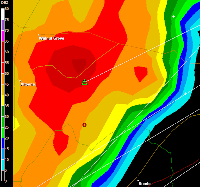
  • Placement of the low is critical as to who gets what.
  • We are talking about a system that hasn't even formed yet!

Now, without further ado, here is what this morning's GFS is telling me, along with my interpretation.


GFS Valid Midnight Sun.

Sunday night:
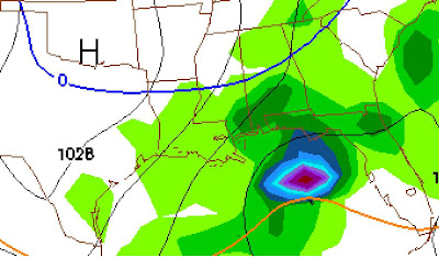
A low forms in the Northwest Gulf while most of the South has temperatures in the 30's and 40's. Rain begins in East Texas, Louisiana, South Arkansas, and West Mississippi. Light snow begins in areas north and west of a line from Little Rock to Memphis to Nashville.


GFS Valid Mon 6 a.m.

Monday between midnight and 6 a.m.:
Low pressure intensifies south of New Orleans. Rain increases in coverage and intensity from East Texas to South Alabama. Snow increases north of a line from El Dorado, AR, to Tupelo, MS, to Huntsville, AL, to Chattanooga, TN.


GFS Valid Monday at Noon.

Monday between 6 a.m. and noon:
Low continues to intensify south of the Alabama coast. Colder air is drawn in from the north and west. Rain continues from East Texas to South Georgia. Rainfall becomes heavy in some areas. The rain snow line moves south. Snow occurs north and west of a line from Tuscaloosa to Birmingham, to Anniston, to Atlanta, to Charlotte.

Monday afternoon and evening:
Rain and snow end from west to east. Rain briefly changes to snow as far south as Monroeville, Alabama and Columbus, Georgia.

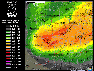
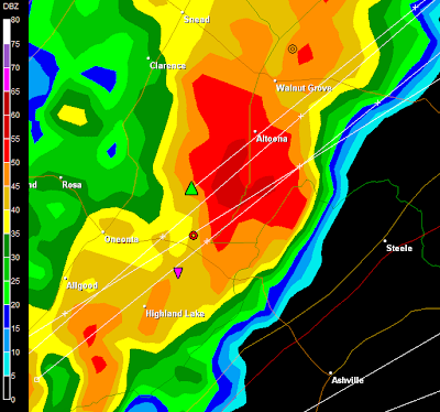
No one knows, but it looks like someone between Nashville and Birmingham could get significant accumulations.

...

Wednesday, January 28, 2009

Cynthiana, Kentucky Ice Storm Photos

Through modern technology I have had the great opportunity to communicate with a childhood friend, classmate, and Sunday School classmate, Kerstin DeRolf. She was kind enough to share these photos she took this afternoon. First, her account:

"We are in luck - so far we haven't lost power, although they don't promise that we can't still lose power. Since I have a saltwater aquarium, that's the one thing I would prefer not to have happen - but I think I am ready if we do. We did the ice storm thing back in 2003, and were without power for close to a week - so for us, this hasn't been nearly as bad.

In general I like living up here - the summers aren't quite as hot, and we get periodic cool days in the summer to recover from the heat. I also like that we do have a chance of snow - the only problem here is that the northern and southern parts of the county sometimes have enough different weather, that the buses can't go on some of the road...therefore we'll have snow days when we wonder what's causing it (tomorrow will be day 8 of this year so far...haven't had school yet this week)."


Our poor pine trees. There are a total of 6 tall and 3 short trees there - I think at least 2 of them are now shorter...


2 water maples from the road.


Branches from 2 water maples - these are what took out our phone line.


Our elm had just recovered from the 2003 storm

Snow lovers, take note...

If you are one of the many Southerners who is hoping to see snow, Monday Feb. 2 might be your day. Models are continuing to suggest a low to form in the Gulf and throw moisture into a cold airmass.
It is way too early to be specific and things can and will change in the model output between now and then. Consider this a pre-watch watch and stay tuned.

Tuesday, January 27, 2009

Quick ice storm update....

So far the hardest hit areas by the ice storm have been northern Arkansas and western parts of Kentucky. However surrounding areas have been affected as well.

A very good source of weather information is the 40/29 TV Weather blog.

...

Monday, January 26, 2009

Ice Storm Warnings


NOAA Graphic

Ice storm warnings are in effect this evening in North texas, Southeast Oklahoma, North Arkansas, South Missouri, Northwest Tennessee, and South Kentucky. Areas from roughly Fort Smith, Arkansas to Lexington, Kentucky seem to be in the bull's eye.

Great information for your areas can be found on special update pages from NWS offices.

NWS Fort Worth, TX

NWS Little Rock, AR

NWS Springfield, MO

NWS Memphis, TN

NWS Nashville, TN

NWS Louisville, KY

...

Wednesday, January 21, 2009

Old Man Winter

We may have seen the last of the really cold air for at least a few days in North Alabama. “Old Man Winter” was with us in full force this morning, though. The low at my location was 15 and there were several locations in North Alabama with colder temperatures than that. There were even a few areas that dropped into single digits. During this cold wave, there has been very little in the way of snow. We did experience a few bands of snow showers and flurries the last few days. The only accumulation was a dusting in some isolated areas. J.B. Elliott posted his usual great list at Alabamawx.com. Here are a few of the lows he reported:

9…Camp Hill, Hamilton

10…Broomtown, Remlap

11…Scrougout

12…Duck Springs, Concord/Hueytown, Muscadine, Gaylesville

13…Vernon, Lincoln, SW Lamar County, Munford, NorthFork, Centre, Muscle Shoals, Pinson, Lafayette

14…Jasper, Wynnville, Reece City, Crossville, Meridianville, Cullman Airport, Centerville, Opelika, Sylacauga, Blue Pond

15…NE Huntsville, Weaver, Clay, Bankhead National Forest, Aliceville

...

Friday, January 16, 2009

COLD

J.B. Elliott, as always, comes up with the best lists. Today on Alabamawx.com he listed the low temperatures from across Alabama and the nation.

His complete list can be found here. Here is an excerpt:

+1 on a mountain in West Jackson County
2 Hytop, Grantley
4 Valley Head, Mentone
5 New Market (Home to Alabama’s lowest ever official temperature.)
6 Russell Cave, Holly Pond (Jason’s mom)
7 Ardmore, NE Huntsville, Belle Mina, Meridianville, Scrougout, Vinemont, Broomtown, Haleyville

...

Coldest weather in six years...


Low was 7.3. Coldest in six years.

At 8:22 it is finally up to 10.0 after 5 hours in single digits.


Low so far in NE Hsv is 7.3. Still holding at 7.5. at 7:45.


Temp/Dewpoint in NE Huntsville is 8.1 / -4.9 at 6:00 am.


Temp/Dewpoint in NE Huntsville is 10.6 / -3.5 at 2:58 a.m.

...

Thursday, January 15, 2009

The temp is going, going, going.....

Temperature in Northeast Huntsville at the foot of Monte Sano is 20.1 at 7:25 p.m.

Temperature in Northeast Huntsville at the foot of Monte Sano is 18.9 at 7:55 p.m.

Temperature in Northeast Huntsville at the foot of Monte Sano is 18.1 at 9:00 p.m.

Temperature in Northeast Huntsville at the foot of Monte Sano is 17.4 at 9:36 p.m. Tied the morning low.

Temperature in Northeast Huntsville at the foot of Monte Sano is 16.3 at 10:36 p.m.

Temp/Dewpoint in NE Huntsville is 16.0 / -0.9 at 10:50.

Temp/Dewpoint in NE Huntsville is 15.4 / -1.1 at 11:10.

Temp/Dewpoint in NE Huntsville is 15.1 / -2.0 at 11:31.
...

Into the freezer, literally...


Milwaukee, Wisconsin at 7 am this morning - NOAA

The coldest weather in many years is pouring down across the United States. The worst of it began to enter North Alabama overnight. We have had colder mornings so far this winter, but this is the beginning of what is likely to be the coldest air in at least six years. The temperature dropped to the freezing point at Midnight overnight (Wednesday night/Thursday morning) and it will stay below freezing until at least Saturday. As of 6:52 this morning, the temperature had dropped to 18.1. (7:17 update -17.6 degrees). Here is how observations went this morning at my location:


1/14/09

(23:58:03) 33 here in Hsv…

(23:59:07) I guess this is the last time I rept a temp above freezing for a few days…..

1/15/09

(04:50:30) 21.6 Here in NE Huntsville at the foot of Monte Sano.

(06:02:40) 19.2 here in NE Huntsville

(06:35:35) 18 now in NE Huntsville

(06:36:03) Wind chill at the HSV Skycam is 3, per Jason Simpson

(06:36:30) Temp at Skycam 19

---


Latest HWO from NWS Huntsville NWS:

HAZARDOUS WEATHER OUTLOOK
NATIONAL WEATHER SERVICE HUNTSVILLE AL
500 AM CST THU JAN 15 2009

ALZ001>010-016-TNZ076-096-097-151930-
LAUDERDALE-COLBERT-FRANKLIN AL-LAWRENCE-LIMESTONE-MADISON-MORGAN-
MARSHALL-JACKSON-DEKALB-CULLMAN-MOORE-LINCOLN-FRANKLIN TN-
500 AM CST THU JAN 15 2009

THIS HAZARDOUS WEATHER OUTLOOK IS FOR NORTH ALABAMA AND PORTIONS OF
SOUTHERN MIDDLE TENNESSEE.

.DAY ONE...TODAY AND TONIGHT...

THE COLDEST AIR IN NEARLY SIX YEARS WILL BE MOVING INTO THE AREA
TODAY...WITH HIGH TEMPERATURES REMAINING BELOW FREEZING. A DANGEROUS
WIND CHILL POTENTIAL IS EXPECTED THIS TONIGHT...AS TEMPERATURES
AFTER DUSK TUMBLE THROUGH THE TEENS...WITH SUSTAINED NORTHERLY WINDS
OF 10 TO 15 MPH. THIS WILL PRODUCE WIND CHILL READINGS RANGING FROM
ZERO TO -10 DEGREES. EVEN COLDER CONDITIONS ARE POSSIBLE IN THE MORE
EXPOSED HIGHER TERRAIN.

.DAYS TWO THROUGH SEVEN...FRIDAY THROUGH WEDNESDAY...

THE VERY COLD WEATHER WILL CONTINUE...WITH AIR TEMPERATURES EXPECTED
TO REMAIN BELOW FREEZING UNTIL SATURDAY AFTERNOON. PRECAUTIONS FOR
COLD WEATHER CONDITIONS...SUCH AS COVERING PIPES AND PROTECTING
PETS...SHOULD BE COMPLETED QUICKLY.

.SPOTTER CALL TO ACTION STATEMENT...

ACTIVATION OF STORM SPOTTERS AND EMERGENCY MANAGEMENT PERSONNEL IS
NOT ANTICIPATED AT THIS TIME.

$$


RSB


Monday, January 12, 2009

Freezing fog in North Alabama


Decatur, Alabama just before 7:30 a.m.


Decatur, Alabama around 7:30 a.m.

There were numerous accidents in North Alabama this morning resulting from poor driving conditions caused by freezing fog. Kudos to the National Weather Service for predicting this and issuing an advisory for it as early as last night.

What is "freezing fog" you may ask? Freezing fog is "regular" fog that persists long enough for water droplets to condense and freeze to exposed surfaces when the temperature is at or below freezing. It is the same principal as freezing rain, when rain falls and freezes on contact with the surface.

There is sometimes confusion between freezing fog and ice fog. Ice fog occurs when the temperature is well below zero and droplets freeze into tiny ice crystals in the air. This is rarely seen outside of the Arctic or Antarctic circles.

...

Sunday, January 11, 2009

Tornado report from Washington County, Alabama

WKRG Channel 5 in Mobile has published a story about what appears to have been a tornado in the town of McIntosh in Washington County, Alabama. See posts from yesterday's storms below. I have not heard any confirmation yet from the NWS Mobile.

Six homes sustained significant damage.

Here is the video published on the web by WKRG:

WKRG.com


Thanks to Roger for his comment on the following:

PUBLIC INFORMATION STATEMENT

NATIONAL WEATHER SERVICE MOBILE AL
200 PM CST JAN 11 2009

...AN EF-1 TORNADO OCCURRED IN MCINTOSH, ALABAMA LAST SATURDAY
AFTERNOON...

A TEAM FROM THE NATIONAL WEATHER SERVICE IN MOBILE, ALABAMA
CONDUCTED A GROUND SURVEY IN MCINTOSH ALABAMA (SOUTHEASTERN
WASHINGTON COUNTY) EARLY SUNDAY MORNING.

RATING: EF-1 TORNADO (ESTIMATED AT 97 MPH)
PATH LENGTH: 1.6 STATUTE MILES
PATH WIDTH: 150-200 YARDS WIDE
LOCATION: FROM BOYKIN BOULEVARD TO VICINITY
OF CIBA PLANT ENTRANCE
NEAR IMMEDIATELY EAST OF TOPTON ROAD AND
U.S. HWY 43 INTERSECTION
TIME: 505 PM CST
DATE: JANUARY 10, 2009
INJURIES: NONE
FATALITIES: NONE

ON SATURDAY AFTERNOON AT ~505 PM...AN EF-1 TORNADO DEVELOPED VERY
NEAR THE INTERSECTION OF TOPTON ROAD AND U.S. HWY 43. THE EXACT
BEGINNING OF THE DAMAGE PATH WAS JUST YARDS FROM WHERE BOYKIN
BOULEVARD AND GEIGY ROAD MEET. THE DAMAGE PATH ENDED NEAR THE CIBA
PLANT. TWO EYEWITNESSES AT THE CIBA PLANT HEARD THE TORNADO IN
ADVANCE AND THEN WITNESSED THE TORNADO AS IT MOVED THROUGH THEIR
LOCATION. FROM THE DAMAGE INDICATORS OBSERVED DURING THE SURVEY,
THE HIGHEST WIND SPEED RATING OF 104 MPH WAS ASSIGNED DUE TO THE
OBSERVATION OF NUMEROUS PINE TREES WHOSE TRUNKS WERE SNAPPED. EF-1
TORNADO WIND SPEEDS RANGE FROM 86-110 MPH...SO THIS IS CLOSER TO THE
UPPER END OF THE RANGE.

DAMAGE INFORMATION: NUMEROUS LARGE PINE TREES WERE SNAPPED AT THEIR
BASES ALONG THE ENTIRE PATH AND EXTENSIVE ROOF DAMAGE WAS OBSERVED
TO SINGLE FAMILY RESIDENCE HOMES. ONE HOME`S CARPORT WAS COMPLETELY
DESTROYED WITH APPROXIMATELY HALF OF ITS ROOF DECK MISSING. THIS
PARTICULAR RESIDENCE PROVIDED EXCELLENT GROUND TRUTH OF THE
CONVERGING WINDS ASSOCIATED WITH THE TORNADO AS IT MOVED THROUGH
THIS LOCATION.

THE CIBA PLANT EXPERIENCED DAMAGE TO SEVERAL OF ITS BUILDING`S
ROOFS (MAINLY THE LIGHT METAL AWNINGS). HIGH WINDS ALSO BLEW THROUGH
THE GLASS DOOR ENTRY-WAYS OF SEVERAL BUILDINGS. ALSO...THE WINDS
BLEW OUT THE REAR WINDSHIELDS OUT OF AN ENTIRE ROW OF PICKUP TRUCKS.
ONE PICKUP TRUCK IN THE PARKING LOT WAS FLIPPED UPSIDE DOWN AND
EXTENSIVE TREE DAMAGE OCCURRED NEAR THE ENTRANCE TO THE PLANT.

A WEB PAGE IS CURRENTLY BEING ASSEMBLED THAT WILL CONTAIN DAMAGE
PHOTOS...A GRAPHICAL DAMAGE PATH AND RADAR DATA. PLEASE SEE:
HTTP://WW.SRH.NOAA.GOV/MOB.

JEFFREY MEDLIN,
SCIENCE AND OPERATIONS OFFICER
NWS MOBILE ALABAMA

...

Saturday, January 10, 2009

One foot of snow in Chi-Town


1/10/09 Photo from my friend and classmate Jill Snider

My sister Cara Wilhelm trudged out in the snow just for me today to take these pics with her cell phone. Officially Chicago reported 12 inches at O'Hare, making this the largest snowfall since 12 inches fell on Jan. 30-31, 2002.


One tornado report


5:13 Mobile Nexrad

At 5:06 Law enforcement in McIntosh, Alabama, in southeastern Washington County reported a tornado.

This area was under the following tornado warning from the NWS Mobile.

BULLETIN - EAS ACTIVATION REQUESTED
TORNADO WARNING
NATIONAL WEATHER SERVICE MOBILE AL
445 PM CST SAT JAN 10 2009

THE NATIONAL WEATHER SERVICE IN MOBILE HAS ISSUED A

* TORNADO WARNING FOR…
SOUTH CLARKE COUNTY IN SOUTHWEST ALABAMA…
SOUTHEAST WASHINGTON COUNTY IN SOUTHWEST ALABAMA…

* UNTIL 515 PM CST

* AT 440 PM CST…NATIONAL WEATHER SERVICE DOPPLER RADAR INDICATED A
SEVERE THUNDERSTORM CAPABLE OF PRODUCING A TORNADO 5 MILES
SOUTHWEST OF TOPTON…OR ABOUT 16 MILES SOUTH OF CHATOM…MOVING
EAST AT 35 MPH.

* THE TORNADO WILL BE NEAR…
MCINTOSH BY 500 PM CST…

...

Surprise tornado warnings....


Several tornado warning have been issued in south and west Alabama this evening.

BMX continues Tornado Warning for Pickens, Tuscaloosa [AL] till 5:45 PM CST ...AT 528 PM CST...THE NATIONAL WEATHER SERVICE CONTINUED TO INDICATE A TORNADO. THIS TORNADO WAS LOCATED NEAR ECHOLA...OR ABOUT NEAR GORDO...MOVING EAST AT 25 MPH.

TORNADO WARNING BIRMINGHAM AL - KBMX 522 PM CST SAT JAN 10 2009 TORNADO WARNING MOBILE AL - KMOB 513 PM CST SAT JAN 10 2009 TORNADO WARNING MOBILE AL - KMOB 445 PM CST SAT JAN 10 2009 TORNADO WARNING MOBILE AL - KMOB 417 PM CST SAT JAN 10 2009 SVR T-STORM WARNING BIRMINGHAM AL - KBMX 335 PM CST SAT JAN 10 2009 TORNADO WARNING JACKSON MS - KJAN 324 PM CST SAT JAN 10 2009 SVR T-STORM WARNING JACKSON MS - KJAN 308 PM CST SAT JAN 10 2009 TORNADO WARNING MOBILE AL - KMOB 215 PM CST SAT JAN 10 2009

Friday, January 09, 2009

A big weather welcome to Huntsville!

I had the opportunity today to meet the newest television meteorologist in the Huntsville television market, Dale Bader. I understand that he will make his on-air debut with WAAY 31 on Sunday night. "Doppler Dale" is from St. Louis and has over 12 years of experience in the private weather industry. He is a graduate of Parks College of St. Louis University with a BS Degree in Aeronautiscs and major in Meteorology. His personal blog is at: http://dopplerdale.blogspot.com he has also posted on the Storm Force 31 Weather blog.

A great visit with an old friend


From Lance George's TV/Radio Museum

I had the privilege of visiting with an old friend from high school today, Lance George. Lance knows more about the media history of North Alabama than anyone I know. He can rattle off the names and details of any station that has ever broadcast radio or television signals in North Alabama and surrounding areas. To this day he has an amazing ability to stay on the cutting edge of electronics and technology.

Among his many interests, Lance has a huge interest in weather. He has computers dedicated to providing 24/7 weather data in his home and his home is wired for weather radio and tornado alerts like no other.

It was a great pleasure to visit with him again. As I did in school, I always learned something when talking to Lance. If there was ever a walking encyclopedia of media, local history, and electronics, Lance is it! Check out his website here.

I was very fortunate the Lord placed me in a tremendous school at a perfect time. I am friends with artists, actors, actresses, rocket scientists, photographers, pediatricians, geniuses, newscasters, social workers, engineers, managers, accountants, lawyers, athletes, and ordinary people who love God, family, and country. The list goes on and on. Lance is one of those special people.

...

Taking a look up North...


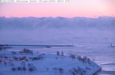
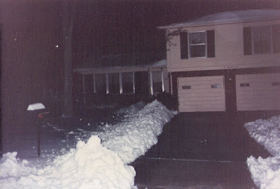
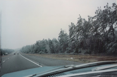
My sister took these images with her cell phone on the North Side of Chicago this morning. She says that they have already had two or three inches of snow. More snow is on the way, though for tonight and Saturday morning.


Tom Skilling of WGN is forecasting 4 to 9 inches north of Interstate 80. Skilling says that this particular snow event marks the 21st measurable snowfall for the Chicagoland area thus far this winter. As of this past Wednesday Chicago had recorded 24.5 inches so far this season.

Skilling wrote, "Measurable snow fell Wednesday for the 19th time, totaling 2 inches at O'Hare International Airport since Tuesday and pushing the city's official tally past the 2 foot mark (24.5 inches). The 2008-09 season is one of only five in the past 124 years in which measurable snow (0.1-inch or more) has fallen that frequently. Over the term of official snow records dating back to 1884, an average of 10 measurable snows has visited the area by Jan. 8 with a seasonal snow tally to date closer to 12 inches -- half as much as has fallen to date this season. Nearly 66 percent of the city's seasonal snow typically falls beyond this date."

Chicago Cubworld live webcam
...

Thursday, January 08, 2009

U.S. temperature trends

News from NOAA today confirms that 2008 was the coldest year in the United States since 1997. Read the full report here.

...

Wednesday, January 07, 2009

Big North Alabama snow 21 years ago today

Great summary from NWS Huntsville.

My pictures:


NE Huntsville, Alabama


These guys took the fun out of it!


NE Huntsville, Alabama


The birds even seemed surprised


Near the Good Hope exit on I-65


Driving back to school, 34 miles east of Tuscaloosa

Video of the coverage by WAFF 48 Huntsville:


Excerpts from The Weather Channel's coverage of the snow in Alabama on January 7, 1988 featuring Jim Cantore, among others. Huntsville received 10" in this storm.

Can it snow when it is 48 degrees?


Graupel

Answer: Yes! If you live in extreme North Alabama you may have noticed what you thought was snow. The temperature at the surface was in the upper 40's but the air was much cooler 4000-5000 feet above the surface. Snow can fall into dry air at the surface if there is a thick enough layer of cold air above the surface. That is what happened today. Technically the precipitation was graupel. Graupel is defined as a form of form of frozen precipitation consisting of snowflakes or ice crystals and supercooled water droplets frozen together. Daniel Lamb of the Huntsville NWS posted about this here.

Some pictures of the unusual event (for Alabama) were posted by James Spann at Alabamawx.com.

...

Calhoun storm damage caused by straight line winds

A survey crew from the National Weather Service Office in Birmingham investigated yesterday's storm damage in Oxford in Calhoun County. They determined that the damage was caused by straight line winds; not a tornado. Here is their statement about the event...

PUBLIC INFORMATION STATEMENT...CORRECTED
NATIONAL WEATHER SERVICE BIRMINGHAM AL
1201 PM CST WED JAN 7 2009

...STRAIGHT LINE WIND DAMAGE IN CENTRAL CALHOUN COUNTY...

A NATIONAL WEATHER SERVICE STORM SURVEY TEAM HAS EVALUATED DAMAGE IN
CALHOUN COUNTY FROM TUESDAY`S STORMS.


RATING: STRAIGHT LINE WINDS (ESTIMATED AT 85 MPH)
LOCATION: INTERSECTION OF HIGHWAY US-78 AND US-431 NEAR
INTERSTATE 20 OXFORD EXIT
MAXIMUM WIDTH: AREA OF DAMAGE
TIME: 504 PM CST
DATE: JANUARY 6, 2009
INJURIES: NONE
FATALITIES: NONE

DAMAGE INFORMATION: PATH LENGTH OF ONE TO TWO MILES. ONE MOBILE HOME
DESTROYED AND ONE COMPLEX DAMAGED WITH A TREE FALLING ON IT. AT
LEAST TWO DOZEN STRUCTURES WITH ROOFS DAMAGED. 40 TREES UPROOTED OR
SNAPPED. SEVERAL POWER LINES DOWNED NORTH OF INTERSTATE 20.
$$
JBW

Short blog status update

You may or may not have noticed that I have updated, revised, and categorized my links on the right sidebar. These are the sites that I use most frequently and if you are looking for weather information you will almost certainly find it there.

One more note. Check out the NSSTC Collaborative Weather Blog. It has really taken off and improved in my opinion. Daniel Lamb, Jason Elliott, and Andy Kula of the NWS in Huntsville are doing great work. You will find the information is timely, complete, and frequently updated. This is a "must add" to your daily weather surfing on the web.

...

Morgan county flooding continues

Flooding continues in notheast Morgan County this morning. Alabama Highway 36 is closed and a friend had to drive a 20+ mile detour to get across the Tennessee River to get to work in Huntsville.

...

Rainfall totals from CoCoRaHS observers


Storm total rainfall estimate - Hytop Nexrad

These are twenty four hour rainfall reports from CoCoRaHS observers in Alabama this morning. These totals do not necessarily represent the storm total rainfall amounts, but rather 24 hour rainfall as of this morning.

County Location Rainfall
Marshall Union Grove 3.6 ESE 4.78
Marshall Grant 6.3 SW 4.71
Jackson Scottsboro 5.6 SSW 4.61
Cullman Logan 2.8 NNE 4.41
Marshall Guntersville 2.2 SW 4.36
Jackson Scottsboro 4.1 SSW 4.32
Marshall Union Grove 4.7 NW 4.31
Marshall Guntersville 2.0 ENE 4.25
Jackson Scottsboro 5.2 ENE 4.23
Marshall Guntersville 4.4 SW 4.19
Jackson Scottsboro 1.7 N 4.19
Cullman Hanceville 1.6 E 4.14
Cullman Cullman 4.4 E 4.10
Marshall Albertville 4.8 WNW 4.02
Marshall Union Grv 7.2 WNW 3.98
Marshall Albertville 5.5 N 3.91
Walker Jasper 3.8 NE 3.87
Cullman Cullman 7.5 SW 3.80
Jackson Woodville 1.7 NE 3.78
Jackson Langston 1.3 NE 3.64
Dekalb Sylvania 3.4 ESE 3.63
Marshall Douglas 6.8 NW 3.57
Madison Gurley 4.3 S 3.50
Morgan Somerville 2.0 SE 3.42
Lamar Sulligent 7.9 SSW 3.40
Jackson Scottsboro 4.6 NW 3.39
Fayette Fayette 1.9 NNE 3.38
Madison Huntsville 7.9 SSE 3.35
Blount Blountsville 1.3 NW 3.31
Madison Owens Xroads 5.3 NW 3.23
Madison Huntsville 7.7 SE 3.14
Marshall Albertville 5.0 ENE 3.13
Fayette Winfield 6.4 S 3.12
Madison Redstone Ars 6.8 SE 3.11
Marshall Albertville 0.2 ENE 3.10
Blount Warrior 4.6 NW 3.09
Madison Owens Xrds 4.7 WNW 3.07
Jackson Princeton 3.6 NW 3.06
Blount Cleveland 5.1 SW 3.05
Dekalb Fort Payne 1.4 WSW 3.04
Madison Owens Xrds 4.7 WNW 3.02
Madison Hampton Cove 1.8 SW 3.01
Madison Hampton Cv 2.1 WNW 3.00

Here are some storm total amounts compliled by ABC 33/40 Skywatcher Michelle Miklik and J.B. Elliott of Alabamawx.com

8.23 Scrougout
8.00 Arkadelphia
7.87 Four miles NE of Jasper
7.49 Hanceville
6.92 Hollytree
6.53 Union Grove
6.41 Blountsville
6.40 Cullman
6..53 NW of Warrior
5.83 Clay/Pinson (Womack Road)
5.67 Clay/Deerfoot
5.40 Scottsboro
4.80 Birmingham Airport
4.25 Concord/Hueytown
4.17 Roebuck
3.35 Bear Creek

...

Public Information Statement, NWS Birmingham

PUBLIC INFORMATION STATEMENT
NATIONAL WEATHER SERVICE BIRMINGHAM AL
545 AM CST WED JAN 7 2009

...NATIONAL WEATHER SERVICE SURVEY TEAM WILL INVESTIGATE STORM
DAMAGE IN NORTHEAST ALABAMA TODAY...WITH DAMAGE REPORTED IN
CALHOUN COUNTY AND POSSIBLY A FEW OTHER COUNTIES IN NORTHEAST
ALABAMA...A NATIONAL WEATHER SERVICE ASSESSMENT TEAM WILL BE
ON SITE LATER THIS MORNING TO SURVEY THESE AREAS. INFORMATION
GATHERED FROM THE SURVEY WILL CONVEYED IN PUBLIC INFORMATION
STATEMENTS AS QUICKLY AS POSSIBLE. A MAJOR CONTRIBUTION TO THE
SUCCESS OF OUR SEVERE WEATHER WARNING PROGRAM IS THE RECEIPT
OF STORM REPORTS FROM ALL OUR CUSTOMERS AND PARTNERS ACROSS
CENTRAL ALABAMA. IF YOU WITNESSED OR ARE AWARE OF ANY STORM
DAMAGE DUE TO HIGH WINDS OR TORNADOES...PLEASE CONTACT
OUR LOCAL EMERGENCY MANAGEMENT OFFICE...OR CALL OUR STORM
REPORTING HOTLINE AT 1-800-856-0758.

...

Tuesday, January 06, 2009

Flooding, tornadoes, and yet more flooding

The big weather story in Alabama today was the excessive rainfall and reports of flooding. There were also a few possible small tornado touchdowns as well, a possible tornado in the Oxford area.

Alabamawx.com has numerous flood pictures from North Alabama here. They have damage pictures from Oxford as well.

Here are a few pictures I took late this afternoon in Decatur.


Reports from NWS Huntsville:

Gurley [Madison Co, AL] nws employee reports FLOOD at 03:02 PM CST -- 6 inches of water reported over the road at the intersection of us hwy 72 and rock cut road in gurley area.

Huntsville [Madison Co, AL] emergency mngr reports FLASH FLOOD at 03:26 PM CST -- intersection of little cove road and mcmullen road completely underwater.

Collinsville [Dekalb Co, AL] law enforcement reports FUNNEL CLOUD at 03:19 PM CST -- report of a funnel cloud along interstate 59 west of collinsville.

issues Flash Flood Warning for Franklin, Lincoln [TN] and Cullman, DeKalb, Jackson, Lawrence, Limestone, Madison, Marshall, Morgan [AL] till 8:30 PM CST (4 Valley Head [Dekalb Co, AL]

nws employee reports FLASH FLOOD at 04:02 PM CST -- report of at least six inches of water over alabama highway 117 in valley head.

Rogersville [Lauderdale Co, AL] emergency mngr reports FLASH FLOOD at 04:10 PM CST -- turner lindsey road in rogersville closed due to flash flooding

Indian Creek at Farrow Rd.: Creek has overrun its banks, and is now flowing into nearby cow pasture south of Farrow. The Creek has not yet reached the actual walking trail, but is only a few feet from it. 2.18" of rain has fallen since 7am Monday, with the majority of the rain falling between 4pm Monday and right now (345pm).

6.50 inchs of rain so far today and still pouring. A couple of places on County Road 91 under water and also on County Road 7

Ne Arab [Marshall Co, AL] emergency mngr reports FLOOD at 08:16 AM CST -- water reported over the roadway at smith circle from small nearby stream.\

Arab [Marshall Co, AL] emergency mngr reports FLOOD at 08:16 AM CST -- bridge on sundown road closed.

Albertville [Marshall Co, AL] emergency mngr reports FLOOD at 08:16 AM CST -- flooding over road at tibbit circleAnderson [Lauderdale Co, AL] emergency mngr reports FLOOD at 09:55 AM CST -- highway 534 is closed due to flooding.

Rogersville [Lauderdale Co, AL] emergency mngr reports FLOOD at 10:18 AM CST -- county road 96 near first creek closed due to flooding.

Albertville [Marshall Co, AL] emergency mngr reports FLOOD at 08:16 AM CST -- bridges reported flooded on needmore road in albertville.

Horton [Marshall Co, AL] emergency mngr reports FLOOD at 08:16 AM CST -- bridge reported flooded on white oak road.

Albertville [Marshall Co, AL] emergency mngr reports FLOOD at 08:16 AM CST -- bridge reported flooded on horton road.

Horton [Marshall Co, AL] emergency mngr reports FLOOD at 08:16 AM CST -- bridge reported flooded on white oak road.

Albertville [Marshall Co, AL] emergency mngr reports FLOOD at 08:39 AM CST -- east henderson road closed due to standing water over roadway.

Arab [Marshall Co, AL] emergency mngr reports FLOOD at 09:10 AM CST -- water reported over scant city road near highway 69.

Anderson [Lauderdale Co, AL] emergency mngr reports FLOOD at 09:14 AM CST -- water reported over the road at a bridge on cr 52 off of highway 207 in anderson.

Falkville [Morgan Co, AL] trained spotter reports FLOOD at 09:18 AM CST -- 1 to 3 inches of water covering road near the intersection of douglas road and highway 55 east.

Anderson [Lauderdale Co, AL] emergency mngr reports FLOOD at 09:44 AM CST -- highway 156 in the anderson community is closed due to high water.
...

Tornado Warning - Cherokee


3:51

BMX issues Tornado Warning for Cherokee [AL] till 4:30 PM CST ...
* AT 354 PM CST...THE NATIONAL WEATHER SERVICE
INDICATED A SEVERE THUNDERSTORM CAPABLE OF
PRODUCING A TORNADO NEAR GAYLESVILLE...OR NEAR
CEDAR BLUFF...MOVING NORTHEAST AT 55 MPH.

Tornado Warning - Cherokee, Etowah, Dekalb

BULLETIN - EAS ACTIVATION REQUESTED
TORNADO WARNING
NATIONAL WEATHER SERVICE BIRMINGHAM AL
314 PM CST TUE JAN 6 2009

THE NATIONAL WEATHER SERVICE IN BIRMINGHAM HAS ISSUED A

* TORNADO WARNING FOR...
WEST CENTRAL CHEROKEE COUNTY IN NORTHEAST ALABAMA...
THIS INCLUDES THE CITIES OF...CENTRE...CEDAR BLUFF...
NORTHEASTERN ETOWAH COUNTY IN NORTHEAST ALABAMA...

* UNTIL 345 PM CST

* AT 314 PM CST...THE NATIONAL WEATHER SERVICE INDICATED A SEVERE
THUNDERSTORM CAPABLE OF PRODUCING A TORNADO NEAR REECE CITY...OR 7
MILES NORTHWEST OF GADSDEN...MOVING NORTHEAST AT 50 MPH.

* THE TORNADO WILL BE NEAR...
TABOR ROAD...CHEROKEE ROCK VILLAGE AND SLACKLAND BY 325 PM CST...
LEESBURG BY 330 PM CST...
SAND ROCK AND 8 MILES NORTHWEST OF CENTRE BY 335 PM CST...
6 MILES NORTHWEST OF WEISS LAKE BY 340 PM CST...
6 MILES NORTHWEST OF CEDAR BLUFF BY 345 PM CST...

THIS INCLUDES INTERSTATE 59 EXIT NUMBER 188.

HEAVY RAINFALL MAY OBSCURE THIS TORNADO. TAKE COVER NOW! IF YOU WAIT
TO SEE OR HEAR IT COMING...IT MAY BE TOO LATE TO GET TO A SAFE PLACE.

THE SAFEST PLACE TO BE DURING A TORNADO IS IN A BASEMENT. GET UNDER A
WORKBENCH OR OTHER PIECE OF STURDY FURNITURE. IF NO BASEMENT IS
AVAILABLE...SEEK SHELTER ON THE LOWEST FLOOR OF THE BUILDING IN AN
INTERIOR HALLWAY OR ROOM SUCH AS A CLOSET. USE BLANKETS OR PILLOWS TO
COVER YOUR BODY AND ALWAYS STAY AWAY FROM WINDOWS.

IF IN MOBILE HOMES OR VEHICLES...EVACUATE THEM AND GET INSIDE A
SUBSTANTIAL SHELTER. IF NO SHELTER IS AVAILABLE...LIE FLAT IN THE
NEAREST DITCH OR OTHER LOW SPOT AND COVER YOUR HEAD WITH YOUR HANDS.

A TORNADO WATCH REMAINS IN EFFECT UNTIL 700 PM CST TUESDAY EVENING
FOR ALABAMA.

---


BULLETIN - EAS ACTIVATION REQUESTED
TORNADO WARNING
NATIONAL WEATHER SERVICE HUNTSVILLE AL
320 PM CST TUE JAN 6 2009

THE NATIONAL WEATHER SERVICE IN HUNTSVILLE HAS ISSUED A

* TORNADO WARNING FOR...
EXTREME SOUTHEASTERN DEKALB COUNTY IN NORTHEAST ALABAMA...

* UNTIL 345 PM CST

* AT 318 PM CST...NATIONAL WEATHER SERVICE DOPPLER RADAR INDICATED A
SEVERE THUNDERSTORM CAPABLE OF PRODUCING A TORNADO NEAR INTERSTATE
59 NEAR THE KEENER COMMUNITY IN NORTHEAST ETOWAH COUNTY...MOVING
NORTHEAST AT 60 MPH.

* LOCATIONS NEAR THE PATH OF THIS TORNADO INCLUDE...
COLLINSVILLE.
DOG TOWN.
ADAMSBURG.
LITTLE RIVER CANYON NATIONAL PRESERVE.
DESOTO STATE PARK.

THIS STORM WILL MOVE RIGHT ALONG THE DEKALB CHEROKEE COUNTY LINE.

A TORNADO WATCH REMAINS IN EFFECT UNTIL 700 PM CST TUESDAY EVENING
FOR NORTHEAST ALABAMA.

Tornado Warning - Blount, Etowah


02:55

Tree and power line damage has been reported near Gallant in Etowah County.


2:50 Birmingham Nexrad

BMX issues Tornado Warning for Blount, Etowah [AL] till 3:15 PM CST ...
* AT 252 PM CST...THE NATIONAL WEATHER SERVICE INDICATED
A SEVERE THUNDERSTORM CAPABLE OF PRODUCING A TORNADO
NEAR ALTOONA...OR 7 MILES EAST OF ONEONTA...MOVING
NORTHEAST AT 55 MPH.

...

New Tornado Warning - Jefferson


1:50


1:50 velocity
BULLETIN - EAS ACTIVATION REQUESTED
TORNADO WARNING
NATIONAL WEATHER SERVICE BIRMINGHAM AL
159 PM CST TUE JAN 6 2009

THE NATIONAL WEATHER SERVICE IN BIRMINGHAM HAS ISSUED A

* TORNADO WARNING FOR...
NORTHERN JEFFERSON COUNTY IN CENTRAL ALABAMA...
THIS INCLUDES THE CITY OF GARDENDALE...
SOUTHEASTERN WALKER COUNTY IN CENTRAL ALABAMA...
THIS INCLUDES THE CITY OF SUMITON...

* UNTIL 230 PM CST

* AT 159 PM CST...THE NATIONAL WEATHER SERVICE INDICATED A SEVERE
THUNDERSTORM CAPABLE OF PRODUCING A TORNADO NEAR WEST JEFFERSON...
OR 8 MILES SOUTH OF DORA...MOVING NORTHEAST AT 50 MPH.

* THE TORNADO WILL BE NEAR...
GRAYSVILLE...SUMITON AND 6 MILES NORTHWEST OF ADAMSVILLE BY 205 PM
CST...
CARDIFF AND BROOKSIDE BY 210 PM CST...
KIMBERLY...MORRIS AND 7 MILES NORTHWEST OF GARDENDALE BY 220 PM
CST...
WARRIOR BY 225 PM CST...
TRAFFORD BY 230 PM CST...

THIS INCLUDES INTERSTATE 65 EXIT NUMBERS 271 THROUGH 282...
AND US 78 EXIT NUMBERS 78 THROUGH 87.

HEAVY RAINFALL MAY OBSCURE THIS TORNADO. TAKE COVER NOW! IF YOU WAIT
TO SEE OR HEAR IT COMING...IT MAY BE TOO LATE TO GET TO A SAFE PLACE.

THE SAFEST PLACE TO BE DURING A TORNADO IS IN A BASEMENT. GET UNDER A
WORKBENCH OR OTHER PIECE OF STURDY FURNITURE. IF NO BASEMENT IS
AVAILABLE...SEEK SHELTER ON THE LOWEST FLOOR OF THE BUILDING IN AN
INTERIOR HALLWAY OR ROOM SUCH AS A CLOSET. USE BLANKETS OR PILLOWS TO
COVER YOUR BODY AND ALWAYS STAY AWAY FROM WINDOWS.

IF IN MOBILE HOMES OR VEHICLES...EVACUATE THEM AND GET INSIDE A
SUBSTANTIAL SHELTER. IF NO SHELTER IS AVAILABLE...LIE FLAT IN THE
NEAREST DITCH OR OTHER LOW SPOT AND COVER YOUR HEAD WITH YOUR HANDS.

TO REPORT SEVERE WEATHER...
CALL 1-800-856-0758.

(14:17:58) BMX cancels Tornado Warning for Walker [AL]
(14:17:58) BMX continues Tornado Warning for Jefferson [AL]
till 2:30 PM CST ...AT 217 PM CST...THE NATIONAL WEATHER SERVICE
CONTINUED TO INDICATE A TORNADO. THIS TORNADO WAS LOCATED NEAR MORRIS...
OR ABOUT NEAR GARDENDALE...MOVING NORTHEAST AT 50 MPH.

Tornado Warning - Dekalb

BULLETIN - EAS ACTIVATION REQUESTED 
TORNADO WARNING
NATIONAL WEATHER SERVICE HUNTSVILLE AL
153 PM CST TUE JAN 6 2009

THE NATIONAL WEATHER SERVICE IN HUNTSVILLE HAS ISSUED A

* TORNADO WARNING FOR...
EASTERN DEKALB COUNTY IN NORTHEAST ALABAMA...

* UNTIL 230 PM CST

* AT 152 PM CST...NATIONAL WEATHER SERVICE DOPPLER RADAR INDICATED A
SEVERE THUNDERSTORM CAPABLE OF PRODUCING A TORNADO NEAR SKIRUM...
MOVING NORTHEAST AT 65 MPH.

* LOCATIONS NEAR THE PATH OF THIS TORNADO INCLUDE...
LEBANON.
FORT PAYNE.
ADAMSBURG.
MENTONE.

Tornado Warning - Tuscaloosa, Walker, Jefferson


1:36 pm Birmingham Nexrad
BULLETIN - EAS ACTIVATION REQUESTED
TORNADO WARNING
NATIONAL WEATHER SERVICE BIRMINGHAM AL
137 PM CST TUE JAN 6 2009

THE NATIONAL WEATHER SERVICE IN BIRMINGHAM HAS ISSUED A

* TORNADO WARNING FOR...
NORTHWESTERN JEFFERSON COUNTY IN CENTRAL ALABAMA...
EASTERN WALKER COUNTY IN CENTRAL ALABAMA...
THIS INCLUDES THE CITIES OF...SUMITON...DORA...CORDOVA...
NORTH CENTRAL TUSCALOOSA COUNTY IN WEST CENTRAL ALABAMA...

* UNTIL 200 PM CST

* AT 137 PM CST...THE NATIONAL WEATHER SERVICE INDICATED A SEVERE
THUNDERSTORM CAPABLE OF PRODUCING A TORNADO NEAR BANKHEAD LOCK AND
DAM...OR 17 MILES NORTH OF HOLT...MOVING NORTHEAST AT 50 MPH.

* THE TORNADO WILL BE NEAR...
GORGAS STEAM PLANT...GORGAS AND 8 MILES SOUTHEAST OF PARRISH BY 150
PM CST...
SUMITON...DORA...BURNWELL AND ROCKY HOLLOW BY 155 PM CST...
SIPSEY AND 6 MILES SOUTHEAST OF LYNNS PARK BY 200 PM CST...

---

BMX continues Tornado Warning for Jefferson, Walker [AL]
till 2:00 PM CST ...AT 149 PM CST...THE NATIONAL WEATHER
SERVICE CONTINUED TO INDICATE A TORNADO. THIS TORNADO WAS
LOCATED 6 MILES SOUTHWEST OF GORGAS STEAM PLANT...
OR ABOUT 14 MILES SOUTH OF CORDOVA...MOVING NORTHEAST AT 50 MPH.

Active weather day today

As previously mentioned, this is becoming an active weather day. As of this writing, two tornado warnings have been issued by the NWS Jackson, MS and flood warnings have been issued in North Alabama.

A tornado watch will be issued soon by the SPC.


Excerpt from the SPC mesoscale discussion:
THE KINEMATIC ENVIRONMENT REMAINS FAVORABLE FOR ORGANIZED CONVECTION
ACROSS THIS REGION...WITH BROAD SLY BOUNDARY-LAYER FLOW TOPPED BY
INCREASINGLY-STRONG/VEERING FLOW WITH HEIGHT. THIS SUGGESTS LOW-LEVEL
ROTATION WITHIN LONGER-LIVED UPDRAFTS WILL BECOME MORE
PREVALENT WITH
TIME...ALONG WITH AN ASSOCIATED INCREASE IN THE
POTENTIAL FOR ISOLATED
TORNADOES. LOCALLY-DAMAGING WINDS WILL ALSO
BE A POSSIBILITY --
PARTICULARLY LATER AS SOME LINEAR ORGANIZATION
ALONG THE SURFACE
COLD FRONT SEEMS LIKELY.


...

Sunday, January 04, 2009

Severe Weather Possible Tuesday


Storm Prediction Center Severe Weather Outlook for Tuesday


Projected helicity values at noon Tuesday


Projected helicity values Tuesday at 6 p.m.

Excerpt from NWS Birmingham's HWO:
THERE IS A SLIGHT RISK FOR SEVERE THUNDERSTORMS ACROSS ALL OF
CENTRAL ALABAMA TUESDAY...ESPECIALLY BETWEEN NOON AND 10 PM. THE
GREATEST THREAT WILL BE FROM DAMAGING WINDS ASSOCIATED WITH BOW
ECHOES. TORNADOES WILL ALSO BE POSSIBLE WITH THE STRONGER
STORMS.
The Storm Prediction Center has placed Central and South Alabama under a slight risk for severe weather on Tuesday. Dew points will be between 60 and 65 in these areas but instability will be limited. However, vertical shear values may be rather strong.

Here is an excerpt from their outlook:
FORECAST HODOGRAPHS INDICATE THAT VERTICAL SHEAR /BOTH THROUGH A DEEP LAYER AND IN THE LOW LEVELS/
WILL BECOME
QUITE STRONG OWING TO COLLOCATION OF 50-60 KT SWLY LLJ AND 80-100+ KT SWLY MIDLEVEL FLOW.
AS SUCH...THE POTENTIAL WILL EXIST FOR
EMBEDDED SUPERCELL AND BOWING STRUCTURES CAPABLE OF DAMAGING
WINDS
AND POSSIBLY A FEW TORNADOES.

Newer Posts Older Posts Home