Tuesday, November 30, 2010

11/29/10 Mississippi Tornadoes

Mississippi tornado damage video and storm survey data from the NWS Jackson...

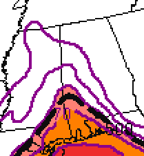
Radar images and warning audio...


WAPT 16 Jackson Video

WAPT Video from Attala County

More video from the Salas community in Attala Co., MS from WAPT Jackson

Storm survey reports from the NWS Jackson today...

PUBLIC INFORMATION STATEMENT
NATIONAL WEATHER SERVICE JACKSON MS
550 AM CST TUE NOV 30 2010

...NWS STORM SURVEY CREWS WILL EXAMINE DAMAGE IN SEVERAL LOCATIONS
TODAY...

PROBABLE TORNADOES HAVE CAUSED SIGNIFICANT DAMAGE IN SEVERAL
LOCATIONS ACROSS CENTRAL MISSISSIPPI OVERNIGHT. LOCATIONS THAT HAVE
BEEN IMPACTED WITH SIGNIFICANT DAMAGE TO THIS POINT INCLUDE...

YAZOO CITY...
ATTALA AND LEAKE COUNTIES SOUTH OF KOSCIUSKO...
WARREN COUNTY NORTHEAST OF VICKSBURG...
STARKVILLE...
SMITH COUNTY NEAR AND WEST OF RALEIGH...

THE NWS WILL BE DISPATCHING THREE STORM SURVEY TEAMS TO EXAMINE
AS MUCH DAMAGE AS POSSIBLE TODAY. HOWEVER...SURVEYING THE DAMAGE
REPORTED TO THIS POINT WILL LIKELY TAKE AT LEAST TWO DAYS...AND IT
IS LIKELY THAT ADDITIONAL STORMS PRODUCED DAMAGE AND POSSIBLE
TORNADOES THAT HAVE NOT YET BEEN REPORTED. WE WILL PROVIDE UPDATES
REGARDING THE PROGRESS OF OUR SURVEY TEAMS...AND WILL ISSUE FINDINGS
AS SOON AS POSSIBLE.

---

PUBLIC INFORMATION STATEMENT
NATIONAL WEATHER SERVICE JACKSON MS
1230 PM CST TUE NOV 30 2010

...TORNADOES CONFIRMED IN SMITH AND OKTIBBEHA COUNTIES BY NWS SURVEY
TEAMS...

COUNTY/COUNTIES: SMITH
BEGINNING POINT: 2.5 MILES E TRAXLER AT 243 AM CST
ENDING POINT: 6 MILES NE RALEIGH AT 258 AM CST
RATING: EF2, MAX ESTIMATED WINDS 125 MPH
PATH LENGTH: 11 MILES
MAXIMUM WIDTH: 0.3 MILE
FATALITIES: 0
INJURIES: 0

SUMMARY OF DAMAGE: AT ITS WIDEST POINT THE TORNADO PRODUCED
SUBSTANTIAL DAMAGE TO A BRICK HOME...REMOVING HALF OF THE ROOF AND
SEVERELY DAMAGING THE REMAINING HALF. THE WALLS OF THE HOME FELL IN
THE SECTION OF THE HOUSE WHERE THE ROOF WAS REMOVED. SEVERAL OTHER
HOUSES RECEIVED MINOR TO MODERATE ROOF DAMAGE. NUMEROUS SHEDS AND
SMALL BARNS WERE DESTROYED OR DAMAGED. TIN ROOFING AND SIDING WAS
REMOVED FROM A STORAGE SHED...SOME OF WHICH BECAME PROJECTILES THAT
WERE FORCED THROUGH THE WALLS OF A WOOD FRAME HOUSE. A MOBILE HOME
WAS BLOWN FROM ITS FOUNDATION. WIDESPREAD TREE DAMAGE OCCURRED.

COUNTY/COUNTIES: OKTIBBEHA
BEGINNING POINT: 1.5 MILES SW STARKVILLE AT 1108 PM CST
ENDING POINT: STARKVILLE AT 1109 PM CST
RATING: EF2, MAX ESTIMATED WINDS 115 MPH
PATH LENGTH: 1.5 MILES
MAXIMUM WIDTH: 200 YARDS
FATALITIES: 0
INJURIES: SOME MINOR INJURIES

SUMMARY OF DAMAGE: INITIAL DAMAGE WAS ROOF AND SIDING DAMAGE TO A
CHURCH ALONG LYNN LANE. THE TORNADO MOVED NORTHEAST THROUGH AN AREA
OF APARTMENT BUILDINGS, CAUSING MINOR TO MODERATE ROOF DAMAGE TO A
NUMBER OF BUILDINGS, AS WELL AS DOWNING SEVERAL TREES. THE TORNADO
THEN MOVED INTO THE PINES TRAILER PARK, WHERE IT DESTROYED A NUMBER
OF MOBILE HOMES. TWO LARGE MOBILE HOMES WERE ROLLED AND DESTROYED,
AND SEVERAL MOBILE HOMES WERE MOVED A SUBSTANTIAL DISTANCE AND
DESTROYED. NUMEROUS LARGE PINE TREES WERE SNAPPED NEAR THE BASE,
WITH SEVERAL LANDING ON MOBILE HOMES CAUSING MAJOR DAMAGE. NUMEROUS
UTILITY LINES WERE SNAPPED AND DOWNED, AND A COUPLE OF POLES WERE
DOWNED. THIS WAS THE LOCATION OF MAXIMUM DAMAGE. THE TORNADO THEN
MOVED NORTHEAST ACROSS LOUISVILLE ROAD, CAUSING ROOF DAMAGE TO
SEVERAL HOMES AND CONTINUING TO SNAP TREES. IT MOVED THROUGH
ANOTHER TRAILER PARK, BLOWING OUT THE SKIRTING ON SEVERAL MOBILE
HOMES AND CAUSING MINOR ROOF AND STRUCTURAL DAMAGE TO A COUPLE. AS
THE TORNADO PASSED THROUGH THE EAST SIDE OF THE STARKVILLE HIGH
SCHOOL COMPLEX, IT TWISTED SOME LIGHT STANDARDS ON THE ATHLETIC
FIELDS AND CAUSED SOME MINOR FENCE DAMAGE. IT THEN CROSSED YELLOW
JACKET DRIVE, BLOWING OUT A PORCH ON A RESTAURANT AND CAUSING SOME
MINOR ROOF DAMAGE. AS IT CROSSED HIGHWAY 12, IT BLEW DOWN A COUPLE
OF TRAFFIC LIGHTS, BLEW OUT A BUSINESS SIGN, AND DAMAGED ANOTHER
PORCH ON A RESTAURANT. THE TORNADO SNAPPED A FEW TREES AND CAUSED
SOME SHINGLE DAMAGE TO A COUPLE OF HOMES ON SOUTH MONTGOMERY STREET,
AND THEN APPEARS TO HAVE DISSIPATED. THE TORNADO WAS RATED EF2
BASED ON THE SMALL AREA OF THE MOST INTENSE DAMAGE IN THE PINES
TRAILER PARK; THE REMAINDER OF THE DAMAGE WAS GENERALLY EF1 IN
NATURE.

---

PUBLIC INFORMATION STATEMENT
NATIONAL WEATHER SERVICE JACKSON MS
515 PM CST TUE NOV 30 2010

...TORNADOES CONFIRMED IN ATTALA AND LEAKE COUNTIES BY NWS SURVEY
TEAM...

COUNTY/COUNTIES: LEAKE/ATTALA
BEGINNING POINT: 3.5 MILES NORTHWEST OF THOMASTOWN AT 938 PM CST
ENDING POINT: 3 MILES EAST MCADAMS AT 950 PM CST
RATING: EF3, MAX ESTIMATED WINDS 140 MPH
PATH LENGTH: 10 MILES
MAXIMUM WIDTH: 400 YARDS
FATALITIES: 0
INJURIES: 6

SUMMARY OF DAMAGE: THE INITIAL DAMAGE WHERE THE TORNADO DEVELOPED
WAS LIMITED TO SOME MINOR TREE DAMAGE ALONG BUDDY ODOM ROAD. THE
TORNADO TRACKED NORTH NORTHEAST AND RAPIDLY BECAME STRONG, WITH EF2
AND LOW END EF3 DAMAGE OCCURRING ALONG THE REST OF THE PATH. THE
TORNADO AFFECTED SHILOH AND BUDDY ODOM ROADS AS WELL AS STATE
HIGHWAY 429 IN LEAKE COUNTY; AND COUNTY ROADS 4022, 4033, 4126,
4045, 4171, 4142 AND STATE HIGHWAY 14 IN ATTALA COUNTY. SEVERAL
MOBILE HOMES, INCLUDING AT LEAST TWO DOUBLE WIDES, WERE COMPLETELY
DESTROYED AT SEVERAL LOCATIONS ALONG THE PATH, WITH DEBRIS CARRIED
WELL AWAY FROM THE REMAINS. IMPRESSIVE TREE DAMAGE OCCURRED AT
NUMEROUS LOCATIONS ALONG THE PATH, INCLUDING A COUPLE OF LOCATIONS
WHERE SOME DEBARKING/DENUDING WAS NOTED. VEHICLES WERE ROLLED OR
TOSSED AT SEVERAL LOCATIONS. A FRAME HOME WAS PUSHED OFF ITS
FOUNDATION AND A NUMBER OF FRAME HOMES SUFFERED MODERATE TO MAJOR
ROOF DAMAGE. NUMEROUS POWER POLES WERE SNAPPED ALONG THE PATH. THE
WIDEST POINT OF THE DAMAGE PATH WAS AROUND A QUARTER MILE, AND WAS
NEAR HIGHWAY 14 IN ATTALA COUNTY.

...

Sunday, November 28, 2010

Severe Weather Monday Night / Tuesday?


Significant Tornado Parameter >=1 at 3 a.m. Tuesday per the SREF


0-3 KM Helicity (shear) >=300m


CAPE 500 J/kg at 3 a.m. Tuesday


SPC Day Two Outlook

It looks like the models are showing a very small window during the early morning hours Tuesday when instability and shear may phase up and provide an opportunity for a slight risk of a tornado in Alabama. Instability will be very limited and it is still questionable if all ingredients will be in place at the same time. It is a situation that needs to be watched closely.

A few notes from official sources...

SPC Day Two Outlook:
THE ARRIVAL OF STRONGER FORCING FOR
ASCENT/HEIGHT FALLS AHEAD OF THE DIGGING SHORTWAVE TROUGH TOWARD
CENTRAL TX SUGGESTS STORMS SHOULD RAMP UP AGAIN LATE IN THE
EVENING/OVERNIGHT OVER THE LOWER MS VALLEY. THE INLAND INTRUSION OF
THE MOIST WARM SECTOR WILL AID IN SUFFICIENT DESTABILIZATION FOR
SURFACE BASED STORMS INTO THE SRN HALF OF MS AND SWRN AL OVERNIGHT.
FURTHER INCREASE IN MIDLEVEL WINDS ATOP THE LLJ WILL SUPPORT STRONG
DEEP LAYER SHEAR AND INCREASING LOW LEVEL HODOGRAPH CURVATURE FOR A
LATE EVENING AND OVERNIGHT TORNADO THREAT...SOME OF WHICH MAY BE
SIGNIFICANT. A THREAT FOR DAMAGING WINDS WILL ALSO BE POSSIBLE.

NWS Birmingham Hazardous Weather Outlook:
THERE IS A CHANCE OF SEVERE THUNDERSTORMS...INCLUDING THE THREAT OF
TORNADOES...ACROSS CENTRAL ALABAMA ON TUESDAY...ASSOCIATED WITH THE
PASSAGE OF A COLD FRONT. BECAUSE OF THE SMALL WINDOW OF OPPORTUNITY
DURING THE HEAT OF THE DAY...AND UNCERTAINTY AS TO THE TIMING OF THE
FRONT...THERE IS STILL A LOW DEGREE OF CONFIDENCE WITH THIS SEVERE
WEATHER THREAT.


NWS Birmingham Forecast Discussion:

ALTHOUGH CONFIDENCE IS LOW AND WINDOW IS SMALL...WILL CONTINUE TO HAVE A
SMALL WINDOW FOR SVR POSSIBLY EVEN TORNADIC ACTIVITY...MOST LIKELY
SE PORTIONS OF CWA IF ANY...DEPENDING ON TIMING OF FRONT.


NWS Huntsville Forecast Discussion:

THE END RESULT FOR US IS A SYSTEM
THAT WILL BE A LITTLE LESS POTENT IN TERMS OF INSTABILITY. HOWEVER...
HELICITY VALUES REMAIN IMPRESSIVE. OVERALL...BELIEVE THE SEVERE
THREAT WITH THE STORMS ALONG THE FRONT ARE RATHER LOW. HOWEVER...WITH
A 50-60 KT LOW LEVEL JET JUST OFF THE SURFACE...ANY MIXING DOWN OF
THOSE WINDS COULD CAUSE BRIEF DAMAGING WIND EVENTS.


...

Looking Back at the 11/24/01 Tornado Outbreak

Looking back 9 years ago...

NWS Birmingham stated, "From approximately 10:00 AM CST until 10:00 PM CST on 24 November 2001, 24 tornadoes touched down across North and Central Alabama [NWS Birmingham CWA (BHM)]. These 24 tornadoes tracked across 25 individual counties, which equated to exactly half of the counties served by the National Weather Service Birmingham Forecast Office. An additional 10 tornadoes touched down in Southwest Alabama [NWS Mobile CWA (MOB)]. In Southeast Alabama [NWS Tallahassee CWA (TLH)], two tornadoes occurred, but they were during the early morning hours of the 25th. Several additional tornadoes struck adjacent states before and after the Alabama tornadoes."

Here are a few videos from local media about the event.

Argo, AL Tornado Video...


Coverage by The Weather Channel


ABC 33/40 Coverage Part 1


ABC 33/40 Coverage Part 2


...

Monday, November 22, 2010

Iron Bowl Weather History


The annual "Iron Bowl" game between the University of Alabama and Auburn University football teams is widely known as one of the most intense, heated, and passionate rivalries in all of sports. The teams play again this Friday in Tuscaloosa. The forecast for game time is tricky as a cold front is expected to pass through at some time that day bringing heavy rain and then a sharp change to cold weather. This year will certainly not be the first year to feature interesting weather in the Iron Bowl. Here's a look at a few of the most interesting Iron Bowl weather events.

December 3, 1983, Legion Field, Birmingham - Auburn 23 Alabama 20


Original image posted by Dr. Tim Coleman on Alabamawx.com

The 1983 iron Bowl started under sunny skies but storms were in the forecast. With just a couple of minutes left in the third quarter, dark clouds appeared in the western sky as the wind picked up, blowing the ball off the tee as Auburn's Al Del Greco prepared to kick off after a 71 yard Bo Jackson touchdown run. About that time, the NWS Birmingham issued a tornado warning for Jefferson County and Birmingham. Pepper Simpson, the well-known Legion Field public address announcer informed the crowd that a tornado warning was in effect. No one inside Legion Field moved an inch as torrential downpours and extremely gusty winds pelted the players, coaches, and fans. Here are a few quotes from fans who attended the game as posted on Tidesports.com.


"I was in the Alabama Million Dollar Band that year. Dr. Ferguson and the Auburn band director agreed that at the start of the third quarter both bands should leave the stadium for their safety."


"I was sitting towards the top of the south end zone. I can distinctly remember the announcement coming over the public address system that a tornado warning had been issued. At that moment, the rain was coming down in buckets and the wind was blowing so hard that it ripped the umbrella out of my hand. The game never stopped and hardly anyone left the stadium looking for cover."

"My dad and I were in the north end zone where Bo Jackson scored. We stayed in our seats throughout. "


"The sky opened up and the winds gusted to 45-55 mph. As the rain picked up the umbrellas came up but the wind turned them inside out." As the tornado warning was read over the PA system nobody made a dash for safety because the score was tight and no one wanted to miss a single play."


I was at that game and it was chilling to hear the tornado warning announced. Frankly, there was nothing fans could have done in the event of an actual tornado.


Meteorologist James Spann worked for Channel 13 in Birmingham at the time. In a post on Alabamawx.com he related his memories of the game, "Severe thunderstorms formed rapidly by mid-afternoon...the WSR-57 radar showed a classic hook echo signature on a storm headed right toward Birmingham...there is no doubt this was the biggest storm to ever hit during an Iron Bowl."


No tornadoes touched down in Jefferson County but seven touched down in the state, including an F3 tornado which killed two in Oxford, Alabama. It was spawned by the same thunderstorm that earlier moved across Legion Field.

December 2, 1967, Legion Field, Birmingham - Alabama 7 Auburn 3 - "Run in the Mud"


Daniel Moore

"I think those were the worst conditions I've ever seen a football game played in," was how legendary Alabama Crimson Tide Coach Paul "Bear" Bryant described the weather in the 1967 Iron Bowl. Time out was called several times during the game because of raincoats blowing from the stands onto the field. During a thunderstorm, Alabama quarterback Kenny Stabler sloshed 47 yards in the mud to give Alabama a 7-3 lead, which is how it ended.


After the play, John Forney, Alabama's radio voice described the play, "He got on the area of the field where there was some grass, got some footing, and outraced Buddy McClinton...and you would just not expect to see a play like that on a field in the condition Legion Field is in." Sportswriter Jimmy Bryan of the Birmingham News described the Auburn players as, "muddy bloody boys-men who wept openly and unashamed." Thousands of fans remained in the stands through torrential rain, lightning, and high wind.


Other games have been noted for cold weather. According to the NWS Birmingham, the coldest iron Bowl since the series resumed in 1948 was the November 26, 1977 game in which Alabama defeated Auburn 48-21 in Birmingham's Legion Field. The high that day was 39 and the low was 26, for an average temperature that day of 32.5 degrees. This year the NWS Birmingham has posted "Iron Bowl Climate Highlights" featuring the five warmest, coolest, and wettest iron Bowls.

...
Newer Posts Older Posts Home