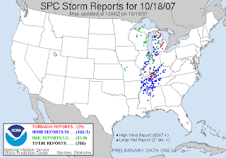
...excerpts from today's outlook...
NWS STORM PREDICTION CENTER NORMAN OK
0749 AM CDT THU OCT 18 2007
VALID 181300Z - 191200Z
...SYNOPSIS... LEAD SHORTWAVE TROUGH THAT AFFECTED
THE PLNS/OZARKS YESTERDAY WILL MOVE NE ACROSS
THE UPR GRT LKS LATER TODAY AS UPSTREAM SPEED MAX
NOW OVER THE CO/NM BORDER REDEVELOPS E ACROSS
THE SRN PLNS TODAY...AND INTO THE MID/LWR MS VLY
TONIGHT.
BREADTH OF WARM SECTOR...60-70 KT DEEP SWLY SHEAR
AND QUALITY OF MOISTURE INFLOW SUGGEST GOOD
LIKELIHOOD FOR DISCRETE SUPERCELLS FOR PERHAPS
A 2-3 HOUR PERIOD EARLY TONIGHT...BEFORE STORMS
MERGE INTO BROKEN LINES. STRONG LOW LVL SPEED
SHEAR AND LOW LCLS SUGGEST POTENTIAL FOR A FEW
STRONG TORNADOES...IN ADDITION TO HIGH WIND AND
HAIL...DESPITE LESS THAN OPTIMAL TIME OF DAY. THE
STORMS MAY CONTINUE TO POSE A THREAT FOR HIGH
WIND AND ISOLATED TORNADOES THROUGH EARLY
FRIDAY...ESPECIALLY IN THE LWR TN VLY.
...GULF CST STATES THROUGH THE PERIOD... A BROAD
AREA OF LOW LVL WAA WILL PERSIST OVER MUCH OF MS/
AL AND WRN GA AND UPR TN VLY THROUGH THE PERIOD
AS DEEP WSW FLOW PREVAILS ON SERN SIDE OF
EVOLVING CNTRL U.S. TROUGH. VERY RICH BOUNDARY
LYR MOISTURE AND LOW LVL VEERING PROFILES MAY
SUPPORT STORMS THAT OCCASIONALLY DEVELOP LOW
LVL ROTATION. THIS WILL BE ESPECIALLY TRUE THIS
AFTN AS HEATING BOOSTS SFC-BASED INSTABILITY...AND
INVOF WEAK INVERTED TROUGH NOW ALONG THE AL/MS
BORDER...WHERE LOW LVL DIRECTIONAL SHEAR WILL BE
MAXIMIZED. WHILE DEEP SHEAR WILL BE WEAK
RELATIVE TO POINTS FARTHER NW...IT WILL BE
SUFFICIENT TO SUPPORT SUSTAINED UPDRAFTS/
POSSIBLE SUPERCELLS WITH A CONDITIONAL THREAT
FOR TORNADOES.


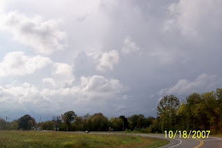
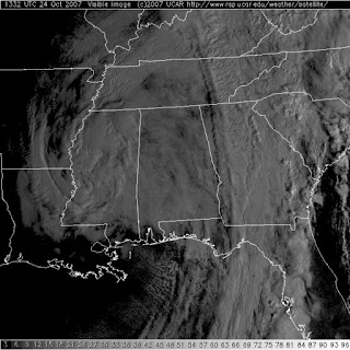 It may look like we have a dying tropical system that has come inland over Louisiana and Mississippi, but we don't.