PUBLIC INFORMATION STATEMENT NATIONAL WEATHER SERVICE HUNTSVILLE AL 1050 AM CDT WED JUL 14 2010...
STRAIGHT-LINE WINDS CAUSE DAMAGE IN MORGAN COUNTY TUESDAY...
STRONG TO SEVERE THUNDERSTORMS RACED ACROSS NORTH ALABAMA TUESDAY /JULY 13/...BETWEEN 11 AM AND 2 PM. SEVERAL REPORTS OF THUNDERSTORM WIND DAMAGE OCCURRED ACROSS MORGAN COUNTY...BETWEEN DANVILLE AND HARTSELLE SHORTLY AFTER NOON. A METAL ROOF WAS PEELED OFF ONE HOME...AND A TREE FELL ON TOP OF ANOTHER HOME. FORTUNATELY...THERE WERE NO INJURIES REPORTED. BASED ON SURVEYING THE DAMAGE AND REVIEWING THE RADAR DATA...THE NWS IN HUNTSVILLE HAS CONFIRMED THAT THE DAMAGE WAS CAUSED BY STRAIGHT-LINE WINDS.
$$DJN
Tuesday, July 13, 2010
Morgan County Storms
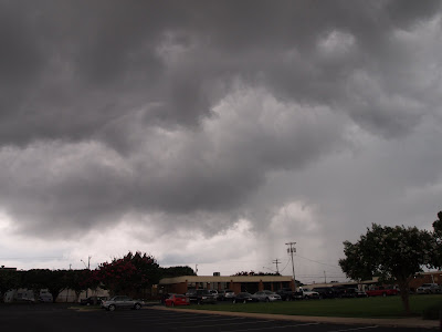
I saw a couple of storms today in Decatur, Alabama. I was working, so in order to see them, I had to time my morning break and half-hour lunch break perfectly. An isolated storm moved just north of my location just after 11:30 a.m. while I was on my morning break. Here are two photos of that storm. It was not severe and no warning was in effect.
11:32 a.m.
11:36 a.m.
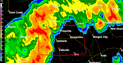
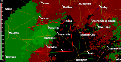
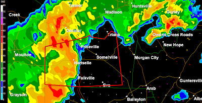
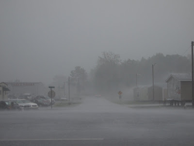
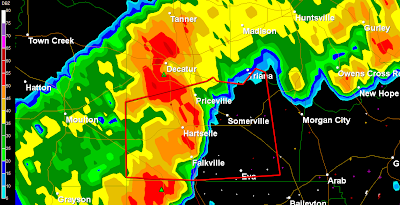
I timed my lunch perfectly. I was about to walk out the door at 12:14 when my NOAA Weather Radio alarm went off to broadcast a severe thunderstorm warning for Morgan County. I left the office at 12:15 and positioned myself at the southern tip of Decatur on US 31. That was probably the part of the storm with the highest winds. I estimate that the peak winds I witnessed were approximately 50 mph. Initially the winds were out of the southwest as the storm began but they gradually became more westerly and then northwesterly. After the highest winds and heaviest rains subsided there was a brief period of frequent cloud to ground lightning. Several strikes were close with one of the strikes being 50-100 yards behind me in a field. Since I was in my car to stay safe from the lightning and to stay dry, I was unable to get any really good photos of the lightning that were close. I may have captured one strike on video after the storm had passed off to the east. If I can capture that one I will post it later. My friend Jennifer New captured some radar images for me. It was a great way for a weather geek to enjoy a 30 minute lunch!
12:21
12:24 p.m. Hytop Nexrad
12:26 p.m.
12:27 p.m.
12:28 p.m.
12:29 p.m. Hytop Nexrad Velocity
12:29 Hytop Nexrad
12:30 p.m.
13:33 Hytop Nexrad
Short video of part of the storm...
...
Severe Thunderstorm in Lawrence Co., AL
These images were taken from the UAH Armor Radar at approximately 12 noon.
DAY 1 CONVECTIVE OUTLOOK
NWS STORM PREDICTION CENTER NORMAN OK
1257 AM CDT TUE JUL 13 2010
VALID 131200Z - 141200Z
...THERE IS A SLGT RISK OF SVR TSTMS FROM THE TN VALLEY INTO THE SRN
APPALACHIANS REGION...
...TN VALLEY/SRN APPALACHIANS REGION...
30-40 KT WLY MID LEVEL FLOW IS EXPECTED TO SPREAD ACROSS THE TN
VALLEY TO SRN APPALACHIANS REGION TO VA/CAROLINAS THIS AFTERNOON AND
EARLY EVENING. DESPITE WEAK MIDLEVEL LAPSE RATES...SURFACE HEATING
WITHIN A RATHER MOIST AIR MASS RESIDING ACROSS THE TN VALLEY AND IN
LEE OF THE SRN/CENTRAL APPALACHIANS IS EXPECTED TO SUPPORT MODERATE
INSTABILITY BY AFTERNOON. TSTMS PRODUCING MAINLY STRONG WIND GUSTS
SHOULD POSE THE GREATEST THREAT ALONG THE CORRIDOR OF STRONGER
MIDLEVEL WLY MIDLEVEL FLOW.
I have been posting about Alabama weather on this blog since April 2006. Here you will find my observations, information provided by the NWS, links to quality weather information from other sources, and historical weather data. Please "follow" me on Twitter and join my "fan" page on Facebook. Twitter and Facebook posts are usually more current/breaking news. I appreciate your visit. Enjoy and come back soon. Thank you!
Follow @bamawx
Bamawx.com - Mike Wilhelm's Alabama Weather Blog on Facebook
Bamawx.com - Mike Wilhelm's Alabama Weather Blog on Facebook
Moisture to the North, Moisture to the South - Skies have been mostly sunny, although a nice field of cumulus clouds has developed over the northwestern quarter of the state, in the vicinity of a slug o...
8 hours ago
Cliff Mass Weather Blog
The Seattle Parks Department Threatens To Reduce Service Due to COVID: Where is the Science? - A recent tweet by the Seattle Park department combines anti-science and intimidation, going so far as to threaten a reduction of park access to the residen...
1 day ago
Jon Davies Severe Weather Notes
March 25, 2021 deadly tornado outbreak in Alabama and Georgia - One week ago today, a deadly tornado outbreak in Alabama (AL) and Georgia (GA) caused 6 deaths and a number of injuries, making it the deadliest tornado ...
2 weeks ago
The Flight of a South Georgia Storm Chaser
That's why everybody advises me this - That's exactly what I wanted! http://link.denaliatving.com Jennifer
2 years ago
MWN Blog
June 2017 Climate Data for Memphis, TN - June Climate RecapFor the first time in recent memory, Memphis International Airport experienced consecutive months of below average temperatures in May an...
3 years ago
Dr. Jeff Masters' WunderBlog
Meteorology of Saturday's Colombian Flood Disaster That Killed 254 - At least 254 people were killed in the in the city of Mocoa (population 40,000) in southwest Colombia near the border of Ecuador early Saturday, when torre...
4 years ago
The Weather Guy
- Since 2014 the Cookeville Weather Guy has taken a hiatus from posting. At some point in the very near future he will resume. For now you can access his Fac...
4 years ago
Severe Plains
Thanksgiving Cleanup - Mild temperatures and an ambitious brother-in-law meant the opportunity to continue the cleanup of Cedar trees in the rear of the property. With loppers, h...
4 years ago
Tennessee Valley Weather
- I'm very sorry, but this blog has finally kicked the bucket. An informal weather blog will be kept at www.thatweatherblog.blogspot.com, as I have the time,...
6 years ago
EYE OF THE STORM
So... You want to chase a tropical cyclone? - ANYONE that wants to chase a hurricane/typhoon/cyclone should watch this. This is as real as it gets! Thankfully Jim made it through Super Typhoon Haiy...
7 years ago
Iowa WX
Grinnell F3 Tornado of 1978 - This may not be the season for tornadoes and we’ve seen in the past that tornadoes can occur at any time no matter what the calendar says. One such occurre...
7 years ago
WeatherScout
Agilent Indonesia 35670A FFT Dynamic Signal Analyzer - Agilent Indonesia 35670A 2 or 4 channel FFT Dynamic Signal Analyzer, DC-102.4 kHz Description The Agilent 35670A is a versatile FFT analyzer with built in ...
7 years ago
Prairiestorm Media Blog
sky drama - Haven't released anything officially, but for the sake of updating... if you're coming here looking for recent posts, STOP. Sky Drama is coming.
8 years ago
Storm Chasing Mikey
Hurricane Sandy - Hurricane Sandy Intensifies Over Jamaica Hurricane Sandy did not disappoint and has indeed become the Historic Storm we started watching on long range fore...
8 years ago
SOUTHERN WEATHER BRIGADE
Virginia Lightning - On Wednesday May 23rd, we had a very isolated cell with a strong hail core move up from North Carolina into Southeastern Virginia around 10:30pm est. I lo...
8 years ago
Justyn Jackson's Weather Blog
Dual-Pol Applications - Dual-pol installations are now being pushed in full force across the country. As of this post, eight radars are equipped with dual-pol, including the proto...
9 years ago
Southwest Georgia Stormtrack
A reminder......... - I work hard and go to considerable expense to capture my work. So please consider this before stealing any of my work. If you do, I will find you and the ...
9 years ago
High Plains Drifter
test image - this is only a test
9 years ago
Alaska Weather Blog
Tuesday March 8, 2011 - Things are really warming up right now! I know that sounds funny, especially since temps are still below freezing, however with the additional daylight (10...
10 years ago
Dan's Wild Wild Weather Journal
Did The Press Miss the Boat on The Black Hole Story?? - This page will soon no longer be updated- go to the new home at THE AGU BLOGOSPHERE You likely heard about it a few days ago. NASA announced the detection ...
10 years ago
Iowa Chaser
NEW BLOG -- Update Link - The Iowa Chaser blog is now the Severe Plains blog! All of the previous posts have been moved, and additional posts since December have been added to the n...
11 years ago
The Long Distance Chase Team...
Best of Hurricane Video!!! - Sorry it took me so long, but I finally put up the Best of Hurricane Video on youtube... It's from Hurricanes Ike, Rita, and Katrina... Honestly words can...
11 years ago
Nikki-Dee’s
*Your Baghdad Weather Glance* -
11 years ago
Tommy Self's North Alabama Weather Blog
Vortex 2 - Well it has been kinda dull weather wise around here the last few days so I turn my attention to the plains and the great tornado hunt.Looks like they ...
11 years ago
WSFA 12 Weather Blog
-
NSSTC Collaborative Weather Blog
-
Green Screen Weather
-
Severe Storm & Hurricane Video & Pictures, Florida Weather, Stock Footage, Storm Chaser Jeff Gammons - Weatherzine.Net