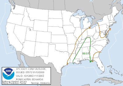

This was the first day one outlook issued at 11:57 last night. Frankly I was surprised that a moderate risk was not issued. I think the main factor they think might reduce our chances for severe weather invoves theability of the atmosphere to recover with sufficient heating and moisture that will be necessary to create instability. The greatest chance of tornadoes is in an area between Jackson, MS and Huntsville, Alabama. They will updating the outlook at 7 a.m.
Excerpt:
MAIN CONCERNS APPEAR TO BE DAMAGING WIND INVOF FRONTAL CONVECTIVE
BAND...WITH POTENTIAL FOR TORNADIC SUPERCELLS AHEAD OF FRONT.  IN
ADDITION TO DAMAGING NONTORNADIC GUSTS...TORNADIC MESOVORTICES IN
LEWP/BOW FORMATIONS ALSO ARE POSSIBLE.
MAIN CAVEATS FOR SVR THREAT INVOLVE THERMODYNAMIC SUPPORT.  CLOUDS
AND AREAS OF PRECIP MAY LIMIT RATE OF DIURNAL HEATING ACROSS MUCH
OF OUTLOOK AREA...ESPECIALLY WITH DISTANCE FROM GULF COAST.


No comments:
Post a Comment