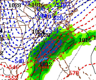
NAM output for Saturday at Noon Central Time
The trend toward a significant winter weather event Friday night and Saturday in Alabama continues according to the NAM model. The noon CT run has been uploaded. Notice the precipitation just north and west of the blue dashed line. That looks like heavy snow is possible. The model has been consistently showing this for 24 hours now.
Good model summary from Meteorologist Tim Coleman.


3 comments:
whats the verdict for B'ham? Is it to early to tell?
Too early for me to tell, but the models range from no precip to 9" of snow. For what it's worth, the NAM is saying 6-9" and it has been more accurate than the GFS this week.
I would feel more comfortable talking about specifics this time tomorrow...
cool, i will check back tomorrow. Don't want to get my hopes up just yet. thanks
Post a Comment