This is the continuation of our chase story that began in a previous post.
We left Tulsa, where we got tangled up in a bunch of detours in downtown. We decided to head west on Highway 51. We wanted to get a bit closer to where storms were probably going to be initiating. After talking with Brett Adair and Greg Nordstrom , we decided to stay off the interstates and turnpikes as much as possible. They pointed out the possibility of those roads being blocked during tornado warnings.
After passing through Stillwater, we arrived at the junction of I-35 and Highway 51. After taking a quick break, we kept a close watch on the radar. The first Oklahoma supercell of the day exploded rapidly to our north in Alfalfa County and a tornado warning was issued at 4:22. We didn't really have time to pursue that one, plus we knew storms would break out further south along the dryline.
Around 4:25 we noticed another storm, just to our northwest and south of the Alfalfa storm was beginning to ramp up. I suggested to John that we should go for it. He wasn't as inclined at first. It appeared to me that it would suck energy away from the Alfalfa storm and cells to the south were slow to develop. My thinking was that we could pursue it and still have time to intercept one later to the south after they started to develop.
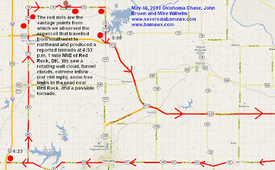
John drove us north, through Perry, OK. We stopped just before we got to Hwy 15. John actually made the very wise decision to pull us back south a few hundred yards. My suggestion was further north. Here we saw a wall cloud that produced a few funnels. The inflow was very strong. Gravel was being slung at the truck. John said his truck was shaking. I had a very hard time walking against the wind to get back to the truck. The wall cloud actually passed immediately north of us. We could look up and see it. It was like looking up at a top. It was wider at the top and almost came down to a point in the middle. In the chaos and the severe winds, I didn't capture much good video of the wall cloud as it went over us. It was rotating rapidly. I actually had my glasses blow off, my tripods were blown over, and got pelted by dirt and gravel. Those were the among the strongest inflow winds I have ever experienced. Rick Lipscomb helped with radar guidance and captured some GR2 shots for us.
After getting the equipment in the truck, we decided to follow the storm east on Hwy 15 through Red Rock. In the video you can see that there were several other chasers on this road. We saw some debris and a tornado was reported to the NWS Norman just before 5 p.m., about a mile to our north. We finally stopped just before the highway ended at Sooner Lake. There we witnessed an amazing inflow cloud. It looked like a cylinder of clouds feeding into the supercell. Some of that was captured on video but the video doesn't really do it justice. Again, even where we were, the inflow winds were very strong. Then we saw what looked like a possible tornado in the vicinity of Sooner Lake, to our east. What appeared to be a debris cloud formed near the surface and gradually filled in upward toward the base of the cloud. If you look closely at the photos, it appeared to have multiple streaks that might have been separate areas of vorticity. Sadly, I captured very little video of that, but there are a few good pictures.
After our adventures in Noble County, we decided to go south as mentioned before. By this time, storms had erupted to our south and the Oklahoma City metro area was getting slammed by several tornadoes. John said that the only way we could get in position for another possible intercept was to go back through Tulsa. Due to traffic, detours, and slow toll booths, it was obvious that this would make it difficult, at best, to get into position. We went through a couple of toll booths. Those workers were slow as Christmas! We also went through an "unmanned" toll booth on an entrance ramp that demanded exact change. We scoured John's truck for what seemed to be an eternity before we decided to go on through without paying. There was no other option! Maybe he hasn't gotten a ticket in the mail yet! John did some excellent driving. We got caught in a traffic jam in Tulsa, and somehow he was able to get off the Turnpike and maneuver his way through some city streets to get us out of town. At that point I thought we were almost done. Brett Adair and Jennifer New were keeping John and I aware, via phone, of the amazing storms to our south.
With Jennifer's help with road and storm position information, we decided to keep going south on the Muskogee Turnpike towards I-4o. It was a bit dramatic, to say the least. There was a strong area of rotation and we didn't have much time to spare to get in position safely. We went for it and thanks to Jennifer's level headed guidance and John's good driving (he had already been driving about 14 out of the previous 18 hours) we got into position for our second intercept.
We stopped in the parking lot of Charlie's Chicken, on Exit 287, at the intersection of I-40 and Hwy 100 in Webber's Falls, OK. There we saw two separate wall clouds and an amazing display of cloud to ground lightning. All of that is on the video. After the weather show, we met the very nice owners of the restaurant, Butch and Sharon Cox. They offered us a wonderful free meal of fried chicken fingers, cole slaw, and mashed potatoes and gravy. They had closed the store. They were super nice. I told them that we Alabamians pride ourselves on hospitality, but that I have never seen it better than they showed.
John and I had considered driving all the way back, but by this point we knew it wasn't an option. We stopped at the Interstate Hotel. John fell asleep while uploading a video. I posted some pictures on Facebook and had a hard time coming down off an adrenaline rush. Finally, at 12:55 a.m., I crashed.
A great day. I want to go back!
...
A few videos from the day by others:
Multiple vortex video
Wakita Tornado
Mustang El Reno Tornado
Video by Tony Laubach
El Reno - Yukon Tornado
Tornado near Wakita, OK
...


No comments:
Post a Comment