Before I get into that, let's look closely at the official statements put out to the public by the NWS Birmingham in the days and hours leading up to the event.
5:00 AM 1/26/14: NWS Multimedia briefing describes uncertainty in the forecast due to conflicting models. It also reminds viewers to check with the State Department of Transportation web page.
2:53 PM 1/27/14: In addition to the snowfall there will be a period for freezing rain accumulations south of I-85. Ice amounts will be around a tenth of an inch in these locations. Expect the wintry mixture of precipitation will begin around 10 am and last until around 6 pm before switching to all snow.
FYI...We have added Bibb, Shelby & Talladega Counties to the Winter Weather Advisory for tomorrow (Tuesday). Potential snow accumulations remain about the same...generally up to 1/2 inch.
5:15 AM 1/28/14: In addition to the snowfall there will be a period for freezing rain accumulations south of I-85. Total ice amounts will range from a tenth of an inch to around a quarter inch for the highlighted locations above. Expect the freezing rain to begin around 10 am and last through about 9 pm before switching to all snow. Travel may become quite hazardous where ice accumulates.
5:35 AM: Wintry precipitation is expected to begin across Central and Southern Alabama this morning and persist into the overnight hours tonight. The highest snow and sleet totals will be across areas along Interstate-85 where 2-3 inches of snow/sleet accumulations are expected. There will be a sharp cut off in snow/sleet accumulations to the north. Locations north of a line from Livingston to West Blocton to Talladega to Heflin can expect to see a dusting to one quarter of an inch. Across locations south of Interstate 85, including the cities of Troy, Eufaula, and Hurtsboro, an extended period of freezing rain is expected before a transition to snow after 6pm.
9:37 AM: A large area of wintry precipitation is currently overspreading Central Alabama. While the heaviest amounts are expected to be along and south of the US 80 and I-85 corridor, hazardous conditions and slick roads are expect nearly area wide.
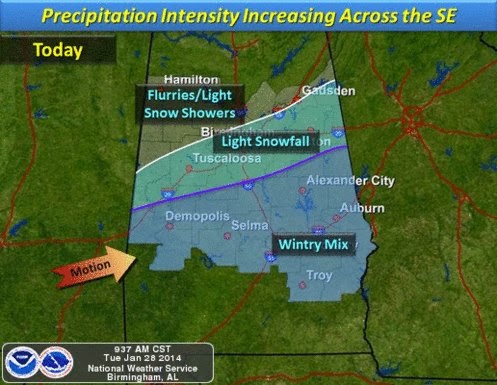
2:41 PM: A large area of wintry precipitation continues to overspread Central Alabama and slowly make its way southeastward. While the heaviest amounts are expected to be along and south of the Interstate 20-59 corridor... hazardous conditions and slick roads are expect nearly area wide. Travel is discouraged.As illustrated here, forecasters pointed out the uncertainty in snowfall forecasts, especially in the South. Forecasts for the Birmingham area ranged generally from a dusting to 1/4 of an inch. 2-3 inches were forecast to the southeast, along the I-85 corridor. What actually occurred in the Birmingham area was 1-2" of snow. The forecast was off by an inch or so, with the caveat given, as always, that there was margin for error. Was the forecast perfect? No. Was it a major bust leading to human suffering? I also say "no" to that! There were certainly other factors at play:
- Just plain bad luck. 1-2" of snow would rarely cause this much havoc, even in the South. It was the perfect storm of weather events and social interaction. If two inches of snow was forecast, many, if not most people would have still been vulnerable.
- The forecast was not that bad. If 11 inches are forecast and 12 inches fall, people would be amazed at the accuracy of the forecast!
- In the days of schools closing for cold dry weather, why was the decision not made to close schools?
- Road conditions were worse than usual due to the fact the weather has been colder than usual The temperatures were colder than forecasts. Road conditions were not expected to be that bad. Weather forecasters are not road condition forecasters.
- Mass panic. I submit that in these days of social media and sensitivity to the weather, many people made the same decision at the same time to leave their places of safety, causing unusual gridlock.
- Governor Bentley issued a State of Emergency the day before for the entire state. However, roads were not prepared by salting them down in advance. Alabama may not have the resources for that, but nevertheless, it would have mitigated this disaster.
- Coordination among public agencies maybe could have been better. The Department of Transportation, EMA, NWS, media outlooks, and local governments can always be improved.
- I am reluctant to say this, because it is only a part of the problem and it goes against the grain of many in our society, but personal responsibility is a factor. Ultimately, we all are responsible for our own safety and weather-awareness.
- The need for integration of social science and the science of meteorology. Public and private meteorologists need to continue to look for better ways to communicate forecast uncertainty, potential outcomes, and how to mitigate these situations.
- Limitations of the science of meteorology! If the same scenario arose next week, we just plain do not have the ability with current technology to pinpoint things like this and the same forecast would probably been made given the same data.
Mike Wilhelm


No comments:
Post a Comment