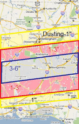
After looking at several models and thinking about history, I am believing that enough moisture pushes into South-Central Alabama to set up a band of significant accumulation in communities such as Thomasville, Selma, Montgomery, and Auburn.
Disclaimer: It is very much too early to put any serious stock in this map (3 days out), but it is interesting to consider nonetheless.
...


1 comment:
Well I'm dying for SNOW ( not a wimpy dusting) here in Oxford, MS! I want to photograph a real snowfall event. Last one here was '98 w/about 6" I think it was. However, we seem to reside in a peculiar place where snow or rain of the much needed sort in summers goes either north of us or just south of us. It's a bizarre thing to watch on radar.
25 miles N of here, Holly Spring got 6" on Mon.! Many areas got inches while Oxford got 0!
So, how is it that we can miss snow again?!
Argh!!!!!
Post a Comment