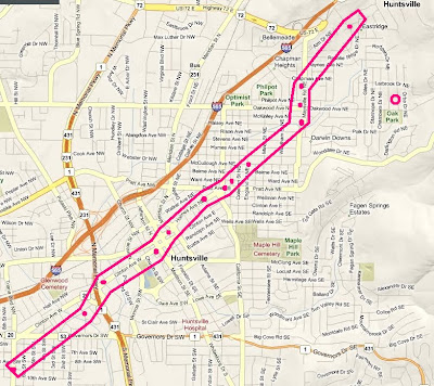
This is a map I have created of the approximate path of the Thursday 1/21/2010 EF2 Tornado in Huntsville, Alabama. This path is based on damage reports combined with the starting and ending points as determined by the National Weather Service Huntsville Storm Survey. It is important to note that this is not an exact path nor was it uniform in size or degree of damage. This is simply an approximation. According to the NWS, "at 5:22 p.m. CST a tornado first touched down near the intersection of Triana Blvd. and 9th Avenue....From there it proceeded northeast for 4.4 miles through Old Town and the Five Points area before lifting near the intersection of Gaboury Lane and Rosalie Ridge Road near Chapman Mountain."
The little pink circle to the right of the track is my location.
...


2 comments:
path roughly parellel to I-565
Very cool. Love the pics and video too - I missed seeing the funnel cloud in person because I was in class, and the tornado warning really caught me off guard. Close call for downtown I'd say!
Post a Comment