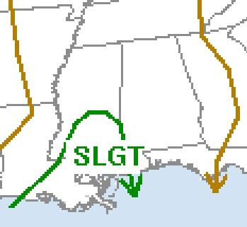
The Storm Prediction Center (SPC) maintains a "slight risk" for severe storms later today and tonight over SE Louisiana and South Mississippi. The reason, I think, that the area outlooked for severe weather is so small is that CAPE (convective available potential energy) values are predicted by the models to be rather low, as shown in the GFS output shown below for 1 a.m. Saturday.

One thing I have learned, though, is that significant tornadoes can and sometimes do occur in relatively low CAPE environments if helicity (the amount of wind shear in the lower atmosphere) is great enough. Healthy shear values are predicted by the models to exist across Alabama at 10 p.m. tonight according to the RUC model. This is shown in the map below. This is especially the case in the southwest part of Alabama.

I am not expecting a major severe weather outbreak, but this one definitely bears watching. This is especially true because last Friday models seemed to underestimate the amount of instability and the fact that the calendar shows we are still in mid-April. The fact that this is a night time event may help to limit stability as well.
Regardless, I still think it is a good time to be ready for any severe weather that may pop up. As J.B. Elliott and James Spann often point out, with severe weather, "expect the unexpected".
Please be weather aware tonight between 6 p.m. and 6 a.m. Saturday!
--------------Edited to add:---------------------
HAZARDOUS WEATHER OUTLOOK
NATIONAL WEATHER SERVICE HUNTSVILLE AL
107 PM CDT FRI APR 18 2008

ALZ001>010-016-TNZ076-096-097-190300-
LAUDERDALE-COLBERT-FRANKLIN AL-LAWRENCE-LIMESTONE-MADISON-MORGAN-
MARSHALL-JACKSON-DE KALB-CULLMAN-MOORE-LINCOLN-FRANKLIN TN-
107 PM CDT FRI APR 18 2008

THIS HAZARDOUS WEATHER OUTLOOK IS FOR NORTH ALABAMA AND PORTIONS
OF SOUTHERN MIDDLE TENNESSEE.

.DAY ONE...TONIGHT...

SHOWER AND THUNDERSTORM ACTIVITY IS EXPECTED INTO THIS EVENING
ACROSS THE TENNESSEE VALLEY AS A COLD FRONT PASSES THROUGH THE
AREA. INITIAL CONVECTION WILL BEGIN TO AFFECT NORTHWEST ALABAMA
LATE THIS AFTERNOON...AND WILL CONTINUE TO MOVE EASTWARD
THROUGH TONIGHT. THE SECOND ROUND OF CONVECTION IS EXPECTED ALONG
THE FRONT LATER TONIGHT AS IT MOVES ACROSS THE AREA. THE GREATEST
THREAT WITH ANY OF THE STRONGER STORMS THAT DEVELOP WILL BE GUSTY
WINDS. SEVERE WEATHER IS NOT EXPECTED DURING THIS TIME.


No comments:
Post a Comment