My map for tonight and tomorrow based on a quick look at some models.
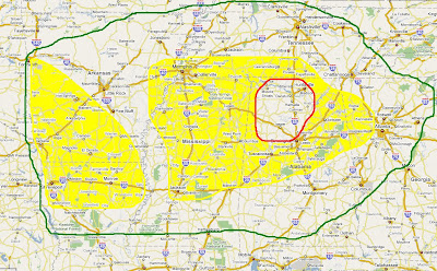
One week after Alabama had 6 confirmed tornadoes and numerous reports of straight-line wind damage, ingredients appear to be coming together again for a significant threat of severe weather tomorrow.
As of this morning, The northeastern one third of the state seems to have the greatest risk of severe weather, including the potential for tornadoes. Ensemble models are showing a relatively high possibility of this in North Alabama. The Day Two Convective Outlook from the Storm Prediction Center has us in a slight risk, but it will be interesting to see if that risk level is elevated as the storm system approaches.
I will be eager to see what the 12:30 p.m. CT SPC Day Two Outlook shows. In the famous words of WHNT 19 Chief Meteorologist Dan Satterfield, "We're watching the weather. We'll keep you advised."
Speaking of Dan Satterfield, he had a very interesting and informative description of numerical weather model forecasting on his blog.
...


1 comment:
It's been years since I heard Dan say that! I had forgotten that was his tag line.
Post a Comment