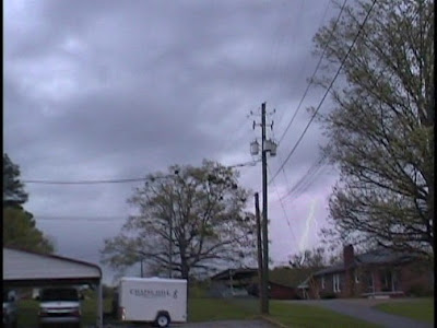
Captured from video
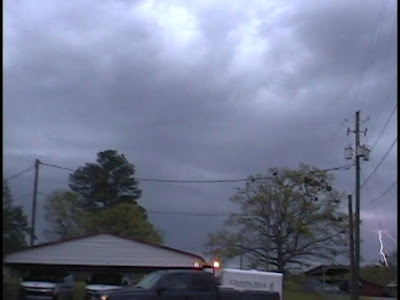
Captured from video

Photo taken by Sarah Vines

Photo by ABC 33/40 Skywatcher

Photo by ABC 33/40 Skywatcher

Lightning captured from Terry Sasser's video

Lightning captured from Terry Sasser's video

3:42

Photo by ABC 33/40 Skywatcher
John Brown, Terry Sasser, Sarah Vines, Michelle Henderson, Rick Lipscomb and I witnessed a wall cloud and rain-wrapped EF1 tornado between 3:20 and 3:45 neat Samantha in Tuscaloosa County, Alabama on April 2, 2009. I was very disappointed to learn when I got home that my best footage of the wall cloud was not actually made because my camera was on "pause". You will notice that around the 4:44 point in the video. Fortunately John was streaming video and I am certain that he will post his coverage soon. I hope that Terry and Rick have some good footage. We were listening to the simulcast of James Spann, Chief Meteorologist at ABC 33/40 on 98.1 FM WTXT. James was streaming John's video live on television. The NWS issued a warning at 3:31, I reported a wall cloud at 3:36, and the tornado was on the ground from 3:43 until 3:44. It was on the ground for approximately 3/5 of a mile. It was confirmed as an EF1 by the NWS Birmingham.
Timeline:
Sarah Vines made a very good call while monitoring radar, saying we should head north immediately to view this storm. I agreed and spoke to John and Rick, who were also in agreement. John made a very good decision to leave the church and move just a little farther north, closer to Mitt Larry Road, where we got an excellent view of the wall cloud and rain-wrapped tornado.
3:23 PM Mike Wilhelm: John and I are at Chapel Hill Baptist Church in Northport on Hwy 43
3:23 PM Mike Wilhelm: John will be streaming from here....
3:26 PM Mike Wilhelm: i am at chapel hill baptist church
3:26 PM Mike Wilhelm: lightning popping good now
3:27 Mike Wilhelm: john streaming live looking nnw from the church
3:29 Mike Wilhelm: impressive ctg lightning to the nw
3:31 BMX issues Tornado Warning for Pickens, Tuscaloosa [AL] till 4:00 PM CDT ...* AT 331 PM CDT...NATIONAL WEATHER SERVICE DOPPLER RADAR INDICATED A SEVERE THUNDERSTORM CAPABLE OF PRODUCING A TORNADO 8 MILES WEST OF COKER...OR 6 MILES SOUTHEAST OF GORDO...MOVING NORTHEAST AT 45 MPH.
3:33 Mike Wilhelm - Mobile Laptop - HSV/Decatur: moving north...
3:36 Mike Wilhelm: wall cloud on hwy 43
3:36 abc3340wx_spann: can u get it on camera
3:36 Mike Wilhelm: john just got here, turning towards it now
3:37 Mike Wilhelm: wall cloud nw of mcdonalds on 43
3:38 Mike Wilhelm: storm looks close to 43
3:39 BMX continues Tornado Warning for Tuscaloosa [AL] till 4:00 PM CDT ...AT 339 PM CDT...NATIONAL WEATHER SERVICE DOPPLER RADAR CONTINUED TO INDICATE A TORNADO. THIS TORNADO WAS LOCATED NEAR ECHOLA...OR 11 MILES NORTHWEST OF NORTHPORT...MOVING NORTHEAST AT 45 MPH.
3:41 Mike Wilhelm: rain beginning to get heavy, sheeting
3:41 ki4mqz Berry, Al: john and mike are one mile south of the mitt larry us43 intersection at the clear creek subdivision
3:41 Mike Wilhelm: just south of mcdonald's by 1/2 mile
3:43 Mike Wilhelm: heading east on mill lary, co rd 56
3:46 Mike Wilhelm: heading n on 69
Terry Sasser's Video:


1 comment:
AWESOME!!!! that was a such a great chase Mike. Love the video. Need to do it again soon!
Post a Comment