After a stop for gasoline, I parked at the Decatur Boat Harbor, on the north shore of the Tennessee River. I called my good friend and chase teammate Jennifer who does an excellent job providing radar support and analysis. She did a really awesome job and posted about this trip while it was in progress here. This was not a classic set up for severe weather in Alabama. Shear was extreme but there was not quite enough instability for much convection.
A thin line of storms travelled across Mississippi during the predawn hours and into Northwest Alabama during the morning. As the line entered Alabama, the sun broke through the clouds at times and the conditions became slightly more conducive for development. Temperatures rose to the mid and upper 60's and dewpoints rose to around 60. I think the extreme gradient winds may have actually inhibited storm development by mixing the air in the low and mid levels of the atmosphere.
11:56 a.m.
By mid morning, however, the Storm Prediction Center pulled the trigger on a Tornado Watch. I chose the Boat Harbor to park because it provided a real good view of the sky, a safe way to exit, and it was in an ideal location for the strongest storm at the time. Winds were fierce as the line approached, gusting over 50 miles per hour based on a web cam located nearby. I tried to take a little video but it was difficult because of the light rain and very gusty winds ahead of the storm. I didn't even take the time to attempt to take any photos at the river.
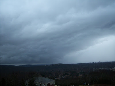
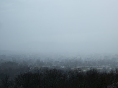
Based on some good advice from Jennifer, I decided to head east toward Huntsville on I-565 to stay ahead of the dryline. Tornado warnings were being issued in Tennessee and it seemed like I would need to stay ahead of these storms, at least into Huntsville. I had to decide to head north of Huntsville on US 231 or to stop at a good vantage point in Huntsville and watch whatever came through Huntsville. Jenn noticed a strong storm forming over Triana, southwest of town so I decided to park at a very scenic site on Chapman Mountain. I was able to take some pictures as broken segments of the line moved across the City of Huntsville. Unfortunately my video was obscured again by the rain showers.

12:57 p.m.

12:59 p.m.
These storms provided a really good view to the west because of a rare dryline that moved across the area. The winds on the west side of Chapman mountain were very strong as the dryline passed. I would estimate that winds were easily over 50 miles per hour on a few different occasions.
James Spann posted some of my best photos on the ABC 33/40 Blog here.
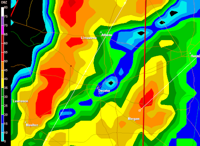
All in all it was an interesting show and the best news is that the storms did very little damage in our area. The above radar captures were saved by Jennifer. She does a really good job of documenting location and time on these. Thanks, Jennifer, for the awesome support as always. It was a good "practice run" for what may be a busy spring season in Alabama. Oh, and I got a good nap afterward but haven't lost the headache.
1:02 p.m.
1:04 p.m.
...


2 comments:
Awesome man. I didn't think it was gonna get going for you early, but that front was so strong. Glad you had a good chase. I was jealous.
SCM
Thanks Mike.... It was one of those fun times where you had a pretty good feeling nothing too serious would happen but it was extremely interesting nonetheless. The winds were awesome.
Post a Comment