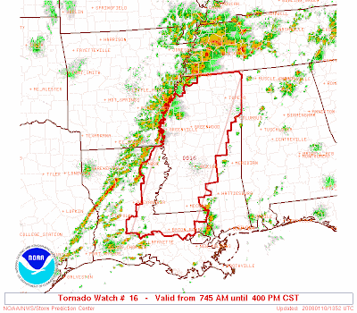
Tornado watch just issued by the SPC.
DISCUSSION...SCATTERED THUNDERSTORMS HAVE BEEN INCREASING ALONG LOW LEVEL JET AXIS ACROSS LA/AR THIS MORNING. STORMS ARE EXPECTED TO BECOME SURFACE-BASED AND INTENSIFY BY MID MORNING AS THEY SPREAD INTO MS. FAVORABLE VERTICAL SHEAR PROFILES AND INCREASING LOW LEVEL MOISTURE WILL SUPPORT A RISK OF SUPERCELLS CAPABLE OF TORNADOES...DAMAGING WINDS...AND HAIL.
I am increasingly concerned that the clouds may lift with passage of the warm front and warm air advection from the south will provide the instability necessary to make this a very dangerous day across the State of Alabama. STAY ALERT!


2 comments:
Keep your eyes trained on the sky. It's show time.
I will do my best...I wish I wasn't so busy here at work...I'd take the afternoon off!
Post a Comment